Scattered severe thunderstorms capable of damaging wind gusts and hail are forecast across the Northeast U.S. and North Dakota Thursday. Heavy to excessive rainfall is possible over eastern New Mexico into western Texas and over the western Florida peninsula Thursday. Read More >
Lake Effect Summary - February 8, 2014
|
|
|
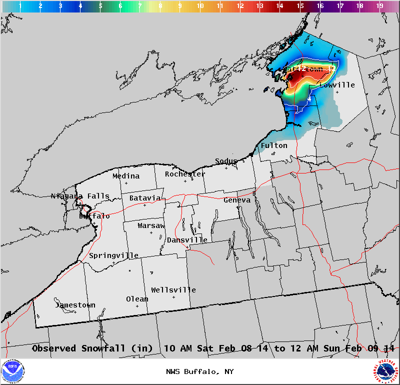
Maximum Snowfall: Lake Erie None; Lake Ontario 15" (Watertown) Duration: 12 hours +/- Prime feature: Low top band; Southwest flow. Our 11th event of the season was again a southwest flow that focused lake effect snow upon the North County. Lake Erie was ice covered, and with high pressure nearby, many areas south of Lake Ontario saw a good deal of sunshine through the day. Early in the morning of February 8th, a diffuse band of lake effect snow continued across the Watertown area and points inland. This band of snow was a weak continuation of a more significant band of snow that blanketed the Eastern Lake Ontario region with snow on the 6th and 7th of the month. Lake induced equilibrium levels were low with this event, around 5,000 feet. This promoted a shallow band of lake effect snow. However, the lake effect band did regenerate just before daybreak as convergence increased over the lake waters. Satellite imagery through the morning hours displayed multiple bands of moisture feeding into the lake effect snow band, such that snowfall rates of one to two inches per hour occurred across the Watertown area and inland towards Carthage. This was not a widespread heavy lake effect snow event, with the bulk of the snow falling across central and southern Jefferson County and into far northwestern Lewis County. Drier air and wind shear weakened the band and as winds became light and convergence decreased, the band fell apart near the Lake Ontario shoreline late Saturday evening.
|