Lake Effect Summary - December 31-January 3, 2016
|
|
|
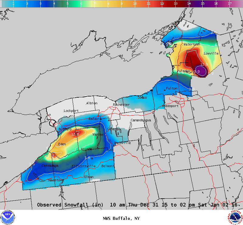
Maximum Snowfall: Lake Erie 12.0" (Perrysburg); Lake Ontario 15" (Highmarket) Duration: 48-60 hours +/- Flake Scale: 1 flake * As the 2015 calendar year was coming to an end, so too was a familiar El Niño pattern. A broad trough over the western half of the country would transition to a High over Low ‘Rex block’, while a phased longwave trough would become established over the eastern half of the continent. This would open the door for the coldest airmass of the season to make its way south from the Canadian Arctic and temporarily settle over the Great Lakes region. The result would be a somewhat prolonged period where accumulating lake snows would fall east of both Lakes Erie and Ontario. The transitory nature of the snow bands and less than favorable synoptic moisture supply would restrain snowfall totals to a foot (Erie) or two (Ontario), while the timing of the heaviest snows to New Year’s Day would help to limit the corresponding impact. This event unfolded on Wednesday night, Dec 30th, as a weak shortwave passed south across the Lower Great Lakes. Colder air in its wake initiated a lake response after midnight, with disorganized lake bands of mixed rain and snow showers becoming more common across parts of the Southern Tier and Eastern Lake Ontario regions. As the cold air deepened over the Lower Great Lakes on Thursday, Dec 31st, instability increased over the abnormally ‘warm’ lake waters. Lake surface temperatures were generally in the mid 40s, which are 10 degrees F above typical late December values. Despite the greater instability though, the lake response was muted by a general lack of synoptic moisture and a pair of shortwaves that kept disorganized bands from setting up over any one given area. Snowfall amounts were generally an inch or less through the daylight hours. During the course of New Year’s Eve (Thursday night), synoptic moisture deepened over the region and the lake effect activity responded by blossoming east of both lakes. The fairly well aligned westerly flow and cap of roughly 10k feet supported snow fall rates of an inch per hour at times across the western Southern Tier and Tug Hill Plateau, where accumulations during the overnight generally ranged from five to as much as 10 inches. The peak of the lake snows occurred on New Year’s Day (Friday) though when the coldest air and deepest convective depth was in place. Well organized bands off both Lakes Erie and Ontario pushed north towards Buffalo and Watertown during the morning as a shortwave approached the region. Snowfall rates of one to two inches an hour and reports of thunder and lightning were found within the moving band. During the afternoon in the wake of the aforementioned shortwave, the steering flow veered to the west and the corresponding bands of moderate to heavy lake snow settled back to the south. This placed the steadiest lake snows over the western Southern Tier and southern portions of the Tug Hill Plateau. Warming and synoptic drying above 5k feet weakened the lake snows on Friday night, particularly east of Lake Erie where a short fetch was already struggling to generate significant snowfall rates. On Saturday, January 2nd, the bands of lake effect once again pushed north as the last in a series of shortwaves backed the steering flow to 250 degrees. The lake snow was not overly impressive at this point though, as a lower cap was in place along with less synoptic moisture. There was also more shear to deal with, and this resulted in broader bands of weaker lake effect with snowfall rates generally under an inch per hour. As was the case the previous day, winds veered to the west in the wake of the shortwave late Saturday and Saturday night. The limiting cap rose a few thousand feet immediately behind the mid level feature, and this allowed the lake bands to briefly become more organized as they moved back to the south across the western Southern Tier and Tug Hill region. The lake snows then weakened considerably on Sunday, Jan 3rd, as shear greatly increased ahead of an approaching arctic front. This led to diffuse, multiple bands of lake snow that gradually ended as flurries. A new area of disorganized lake effect became established within the northerly flow of arctic air late Sunday and Sunday night, but this activity was found in a completely different area than what fell during the previous few days.
|


 Follow us on YouTube