Peachtree City, GA
Weather Forecast Office
June 6, 2005
Thunderstorms developed in the afternoon heat and humidity across Georgia on June 6, 2005. Although the level of instability in the atmosphere was only marginally supportive of severe thunderstorms, a number of storms did produce hail, especially across the northern half of the state. Hail was mostly small, but several locations did report hail as large as pennies between 1 pm and 6 pm. Large hail up to the size of golfballs occurred during the 7 o'clock hour in Hall, Gwinnett, and Banks counties. Storms weakened significantly after sunset.
A few of the thunderstorms produced strong, gusty winds. The most significant of these occurred in Morgan county, where a number of large trees were blown down . There was also some roof damage to a few homes, barns and outbuildings. Ms. Gwenda Ruark, Morgan County EMA Director, surveyed the damage and provided the photos below. As can be seen in the radar images, the storm that produced the damage developed rapidly. This "pulse" thunderstorm had a narrow updraft core, but apparently produced a wet microburst before ending its life cycle. ![[ damage occurred in the Buckhead area of Morgan County ]](/images/ffc/events/morg6605/morgbuck1.gif) 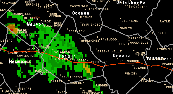 Base reflectivity from Peachtree City radar between 6 pm and 630 pm edt.
|
|||||||
Current Hazards
Submit Storm Report
Outlooks
Georgia Road Conditions
Nationwide
Local Storm Reports
Local
Forecasts
Recreational Forecast
Fire Weather
Forecast Discussion
Incident Support
Tropical Weather
Local
Computer Models
Graphical
Aviation Weather
Activity Planner
Current Weather
Rivers/Lakes
Satellite Images
Observations
Maps
Radar Imagery
Peachtree City
Regional Loop
Nationwide
Warner Robins
US Dept of Commerce
National Oceanic and Atmospheric Administration
National Weather Service
Peachtree City, GA
4 Falcon Drive
Peachtree City, GA 30269
770.486.1133
Comments? Questions? Please Contact Us.


![[ barn roof peeled back ]](/images/ffc/events/morg6605/morg6605.jpg)
![[ barn roof peeled back ]](/images/ffc/events/morg6605/morg6605a.jpg)
![[ shed damage ]](/images/ffc/events/morg6605/morg6605b.jpg)
![[ well house roof ]](/images/ffc/events/morg6605/morg6605c.jpg)