
Another round of heavy rainfall will renew concerns for additional flash flooding and landslides in southern California around burn scars and coastal mountain ranges. A low pressure system is bringing enhanced snowfall downwind from the lower Great Lakes into the Northeast mountain ranges. Above average temperatures will challenge or break daily record high temperatures across the southern Plains. Read More >
Overview:
(BE SURE TO CLICK THE VARIOUS TABS BELOW FOR A VARIETY OF JUNE 2017 CLIMATE INFORMATION!)
|
Recap of June 2017 Weather for the NWS Hastings Coverage Area:
|
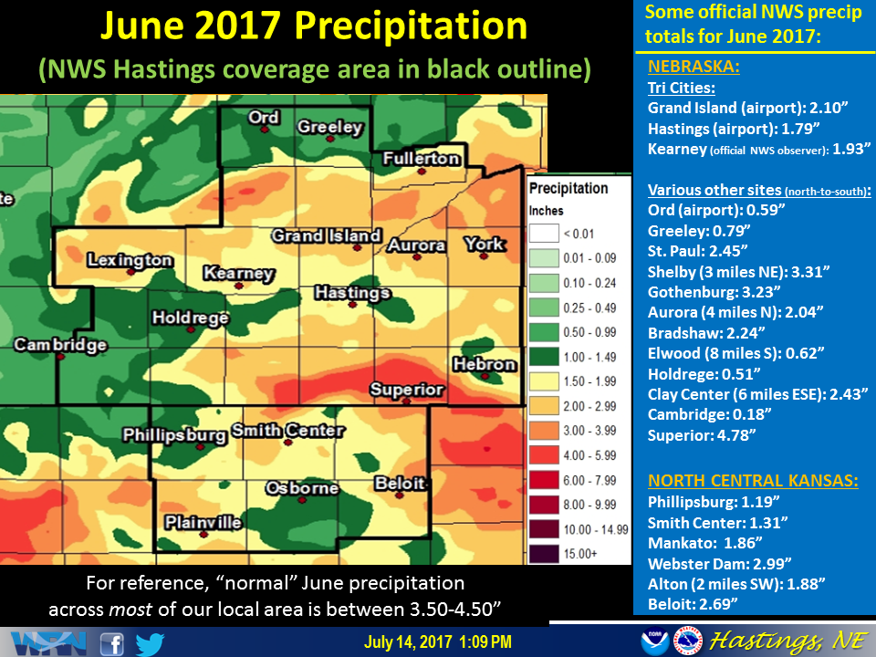 This graphic features a precipitation map for June 2017, along with a partial listing of totals from official NWS stations. (Click image to enlarge) |
Grand Island & Hastings Details (Including 12-Month History):
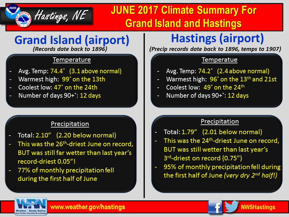 |
| Detailed June 2017 info for Grand Island/Hastings (Click to enlarge) |
 |
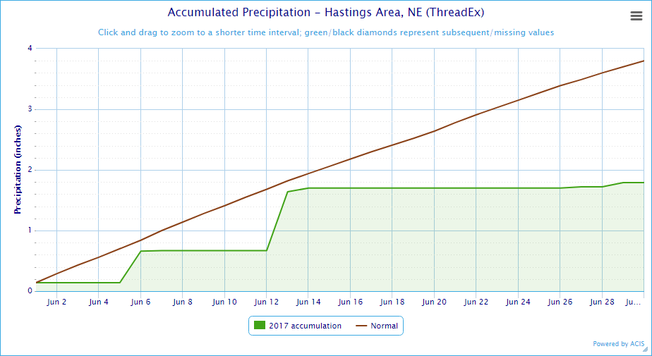 |
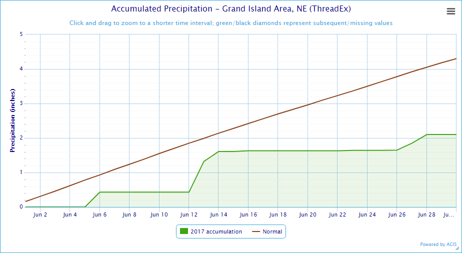
| Grand Island Precipitation Summary: The green line indicates cumulative observed precipitation for June 2017.The brown line indicates "normal" June precipitation based on 30-year data from 1981-2010. (click to enlarge) | Hastings Precipitation Summary: The green line indicates cumulative observed precipitation for June 2017. The brown line indicates "normal" June precipitation based on 30-year data from 1981-2010. (click to enlarge) |
| Grand Island (Regional Airport ASOS) - July 2016 - June 2017 | ||||||||||||
| July | Aug. | Sep. | Oct. | Nov. | Dec. | Jan. | Feb. | Mar. | Apr. | May | June | |
| Average High (F) | 87.0 | 84.4 | 78.8 | 70.7 | 57.3 | 37.3 | 34.6 | 50.8 | 54.4 | 63.1 | 72.7 | 87.5 |
| Average Low (F) | 65.1 | 62.7 | 55.0 | 42.6 | 32.7 | 14.5 | 17.9 | 24.8 | 30.0 | 39.2 | 49.6 | 61.2 |
| Average Temperature (F) | 76.0 | 73.5 | 66.9 | 56.7 | 45.0 | 25.9 | 26.3 | 37.8 | 42.2 | 51.1 | 60.3 | 74.4 |
| Departure From Normal | -0.2 | -0.5 | +1.8 | +4.5 | +6.9 | -0.8 | +1.2 | +8.7 | +2.8 | +0.5 | -0.9 | +3.1 |
| Precipitation (in) | 4.10 | 0.57 | 2.53 | 0.12 | 1.37 | 0.81 | 1.07 | 0.25 | 0.81 | 2.64 | 5.28 | 2.10 |
| Departure From Normal | +0.70 | -2.55 | +0.30 | -1.74 | +0.20 | +0.18 | +0.54 | -0.43 | -0.99 | +0.11 | +0.87 | -2.20 |
| Snowfall (in) | 0.0 | 0.0 | 0.0 | 0.0 | 0.4 | 1.4 | 2.4 | 3.5 | 1.2 | T | 0.3 | 0.0 |
| Departure From Normal | 0.0 | 0.0 | -0.1 | -1.0 | -2.7 | -3.7 | -4.1 | -2.8 | -4.2 | -1.5 | +0.3 | 0.0 |
| Hastings (Municipal Airport ASOS) - July 2016 - June 2017 | ||||||||||||
| July | Aug. | Sep. | Oct. | Nov. | Dec. | Jan. | Feb. | Mar. | Apr. | May | June | |
| Average High (F) | 87.7 | 84.9 | 78.6 | 71.3 | 57.4 | 37.7 | 35.7 | 51.4 | 55.4 | 63.4 | 72.8 | 86.3 |
| Average Low (F) | 66.0 | 63.4 | 56.1 | 44.0 | 34.2 | 15.6 | 19.4 | 25.8 | 31.3 | 40.7 | 49.5 | 62.1 |
| Average Temperature (F) | 76.9 | 74.1 | 67.3 | 57.6 | 45.8 | 26.6 | 27.6 | 38.6 | 43.4 | 52.1 | 61.1 | 74.2 |
| Departure From Normal (F) | -0.2 | -0.2 | +1.7 | +5.0 | +7.1 | -1.0 | +1.6 | +8.7 | +3.5 | +1.4 | -0.2 | +2.4 |
| Precipitation (in) | 2.22 | 1.77 | 1.80 | 0.22 | 1.46 | 0.61 | 0.83 | 0.27 | 1.08 | 3.24 | 6.42 | 1.79 |
| Departure From Normal (in) | -1.52 | -1.53 | -0.76 | -1.77 | +0.17 | 0.00 | +0.42 | -0.22 | -0.71 | +0.68 | +1.85 | -2.01 |
| Snowfall (in) | 0.0 | 0.0 | 0.0 | 0.0 | 0.1 | 1.0 | 3.7 | 4.3 | 1.2 | 0.2 | 0.6 | 0.0 |
| Departure From Normal (in) | 0.0 | 0.0 | -0.2 | -1.0 | -2.5 | -5.1 | -2.3 | -2.2 | -4.0 | -1.0 | +0.6 | 0.0 |
Kearney - 12 Month Climate History:
All data here is from the official NWS observer at Kearney airport, with 24-hour observations taken around 7 a.m. ** PLEASE NOTE: This official Kearney data differs somewhat from the unofficial data recorded by the automated airport system (KEAR) **
| Kearney Airport (Coop Observer) - July 2016 - June 2017 | ||||||||||||
| July | Aug. | Sep. | Oct. | Nov. | Dec. | Jan. | Feb. | Mar. | Apr. | May | June | |
| Average High (F) | 86.4 | 84.3 | 79.3 | 70.8 | 58.6 | 37.8 | 36.9 | 50.0 | 54.6 | 62.5 | 70.2 | 86.6 |
| Average Low (F) | 63.4 | 61.8 | 53.0 | 40.8 | 33.4 | 14.8 | 19.5 | 24.1 | 28.6 | 38.8 | 45.9 | 59.7 |
| Average Temperature (F) | 74.9 | 73.1 | 66.2 | 55.8 | 46.0 | 26.3 | 28.2 | 37.1 | 41.6 | 50.7 | 58.1 | 73.2 |
| Departure From Normal (F) | +0.2 | +0.5 | +2.7 | +4.9 | +9.0 | +0.4 | +3.6 | +9.0 | +3.9 | +2.0 | -1.4 | +3.4 |
| Precipitation (in) | 3.38 | 1.47 | 1.20 | 0.12 | 1.56 | 0.90 | 0.90 | 0.30 | 1.63 | 1.87 | 6.03 | 1.93 |
| Departure From Normal (in) | +0.10 | -1.61 | -0.87 | -1.92 | +0.54 | +0.33 | +0.41 | -0.25 | -0.16 | -0.36 | +1.85 | -2.00 |
| Snowfall (in) | 0.0 | 0.0 | 0.0 | 0.0 | 0.2 | 1.0 | 4.5 | 5.2 | 0.7 | T | 1.6 | 0.0 |
| Departure From Normal (in) | 0.0 | 0.0 | -0.2 | -0.7 | -2.9 | -2.5 | +0.1 | +0.1 | -3.9 | -1.8 | +1.6 | 0.0 |
Ord - 12 Month Climate History:
Winter precipitation totals often include NWS Cooperative Observer data due to the automated airport equipment under-measuring snowfall liquid equivalent.
| Ord (Evelyn Sharp Field Airport ASOS) - July 2016 - June 2017 | ||||||||||||
| July | Aug. | Sep. | Oct. | Nov. | Dec. | Jan. | Feb. | Mar. | Apr. | May | June | |
| Average High (F) | 85.2 | 83.6 | 77.2 | 70.3 | 56.7 | 37.6 | 34.1 | 48.4 | 53.7 | 61.7 | 69.7 | 86.3 |
| Average Low (F) | 62.3 | 60.4 | MSG | 37.4 | 28.1 | 9.3 | 14.2 | 19.8 | 28.7 | 37.9 | 44.1 | 56.9 |
| Average Temperature (F) | 73.8 | 72.0 | MSG | 53.8 | 42.4 | 23.5 | 24.1 | 34.1 | 41.2 | 49.8 | 56.9 | 71.6 |
| Departure From Normal (F) | -0.6 | -1.0 | MSG | +4.2 | +6.1 | -1.4 | -0.5 | +6.3 | +3.5 | +1.0 | -2.4 | +2.4 |
| Precipitation (in) | 6.66 | 0.44 | 1.70 | 0.09 | 1.26 | 0.41 | 1.15 | 0.79 | 1.83 | 4.25 | 3.10 | 0.59 |
| Departure From Normal (in) | +3.69 | -2.72 | -0.74 | -1.84 | +0.19 | -0.18 | +0.78 | +0.35 | +0.38 | +1.66 | -0.71 | -3.53 |
| Snowfall (in) | 0.0 | 0.0 | 0.0 | 0.0 | 3.0 | 2.7 | 11.9 | 10.4 | 1.9 | 1.0 | 6.0 | 0.0 |
| Departure From Normal (in) | 0.0 | 0.0 | 0.0 | -1.1 | -2.3 | -4.7 | +5.1 | +4.4 | -4.0 | -1.5 | +6.0 | 0.0 |
Smith Center, KS - 12 Month Climate History:
All data is from the official NWS observer, with 24-hour observations taken around 7 a.m. As a result, data may vary slightly from true "Calendar Day" totals.
| Smith Center KS (NWS Coop Observer) - July 2016 - June 2017 | ||||||||||||
| July | Aug. | Sep. | Oct. | Nov. | Dec. | Jan. | Feb. | Mar. | Apr. | May | June | |
| Average High (F) | 90.5 | 86.5 | 81.3 | 73.9 | 61.0 | 38.7 | 39.0 | 53.4 | 58.5 | 65.4 | 73.9 | 89.8 |
| Average Low (F) | 66.1 | 62.8 | 55.6 | 43.5 | 32.9 | 14.2 | 18.5 | 24.2 | 30.2 | 40.0 | 46.8 | 60.9 |
| Average Temperature (F) | 78.3 | 74.7 | 68.5 | 58.7 | 47.0 | 26.5 | 28.7 | 38.8 | 44.4 | 52.7 | 60.4 | 75.4 |
| Departure From Normal (F) | -1.4 | -2.5 | +0.3 | +3.9 | +6.6 | -2.3 | +1.0 | +6.8 | +2.8 | +0.2 | -3.3 | +1.4 |
| Precipitation (in) | 6.07 | 5.13 | 5.07 | 0.09 | 0.99 | 0.56 | 1.46 | 0.27 | 1.26 | 3.32 | 7.03 | 1.31 |
| Departure From Normal (in) | +2.20 | +1.83 | +3.03 | -1.79 | -0.23 | -0.10 | +0.97 | -0.31 | -0.61 | +1.05 | +3.11 | -2.30 |
| Snowfall (in) | 0.0 | 0.0 | 0.0 | 0.0 | 0.0 | 3.1 | 1.1 | 1.8 | 0.2 | 0.0 | 0.0 | 0.0 |
| Departure From Normal (in) | 0.0 | 0.0 | -0.2 | -0.4 | -1.8 | -0.1 | -2.6 | -2.3 | -2.4 | -0.6 | 0.0 | 0.0 |
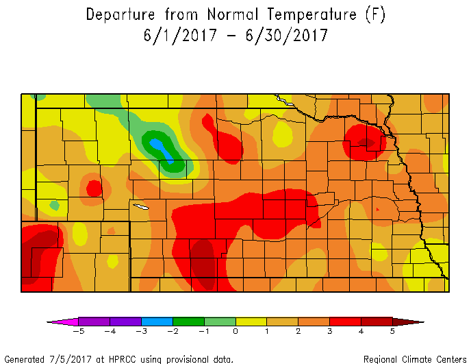
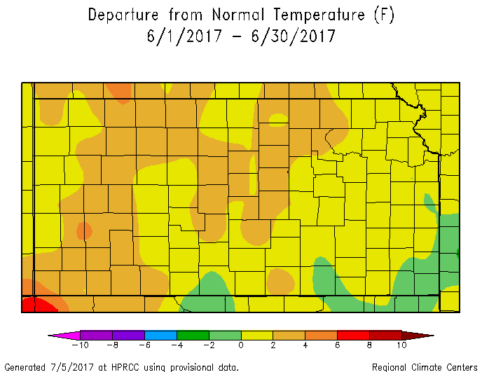
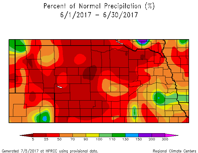
Area Temperature & Precipitation Departure From Normal Maps:
These images depict June 2017 monthly temperature departure from normal & precipitation percent-of-normal for both Nebraska & Kansas. Images are courtesy of the High Plains Regional Climate Center (HPRCC). Click images to enlarge.
 |
 |
 |
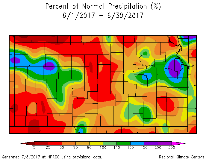 |
| Departure from Normal Temperature - NE (left) & KS (right) | Percent of Normal Precipitation - NE (left) & KS (right) | ||
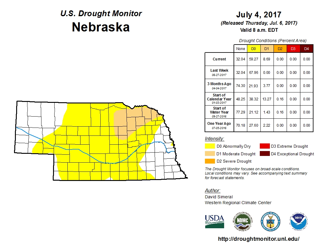
Drought:
The following drought images, current as of July 4, 2017, are courtesy of the U.S. Drought Monitor
Brief summary of changes during June for the NWS Hastings coverage area:
Given that the vast majority of the NWS Hastings coverage area received below normal June precipitation (many places no more than half of normal), along with the fact that the month featured slightly above normal heat, the area unfortunately started to see the first signs of a return to drought stress. By month's end, the majority of the area was assigned Abnormally Dry (D0), with even portions of Greeley and Valley counties degraded to Moderate Drought (D1).
 |
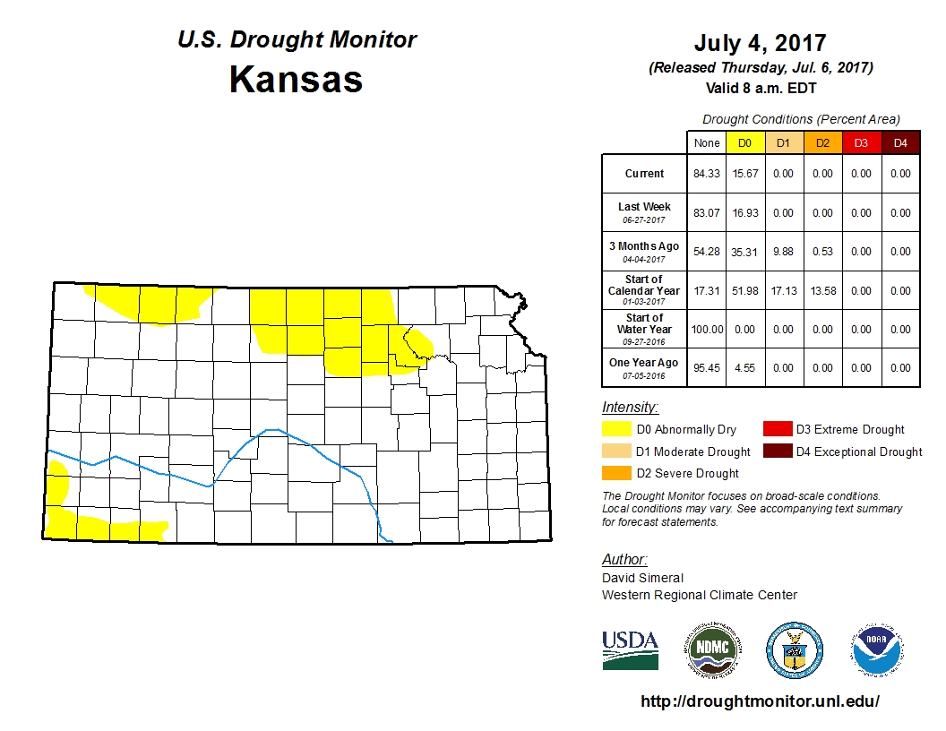 |
| Drought Monitor for Nebraska (left) & Kansas (right). Valid as of July 4, 2017 (click to enlarge) | |
Monthly Extremes for the NWS Hastings Coverage Area:
...A FEW OF THE HOTTEST HIGH TEMPERATURES DURING JUNE 2017...
(all data from NWS cooperative observers or automated airport sites)
103 degrees...Webster Dam, KS (13th)
102 degrees...Beaver City (21st)
101 degrees...Cambridge (21st) - Smith Center, KS (21st)
100 degrees...Gothenburg (21st) - Lexington Airport AWOS (21st) - 2SW Alton, KS (21st)
...A FEW OF THE COOLEST LOW TEMPERATURES DURING JUNE 2017...
(all data from NWS cooperative observers or automated airport sites)
40 degrees...Greeley (24th)
41 degrees...Ord Airport ASOS (24th)
42 degrees...2W Genoa (24th)
43 degrees...Cambridge (24th)
...A FEW OF THE HIGHEST MONTHLY RAINFALL TOTALS DURING JUNE 2017...
(all data from NWS cooperative observers or automated airport sites unless specified)
6.54 inches...4E Red Cloud (NeRAIN observer)
5.77 inches...Red Cloud
4.91 inches...Guide Rock (NeRAIN observer)
4.78 inches...Superior
3.94 inches...Loup City
3.53 inches...Polk
3.31 inches...3NE Shelby
3.23 inches...Gothenburg
2.99 inches...Webster Dam, KS
...A FEW OF THE LOWEST MONTHLY RAINFALL TOTALS DURING JUNE 2017...
(all data from NWS cooperative observers or automated airport sites unless specified)
0.18 inch...Cambridge
0.51 inch...Holdrege
0.59 inch...Ord (airport ASOS)
0.61 inch...Wilsonville
0.62 inch...8S Elwood
0.65 inch...Edison
0.67 inch...6NNW Oxford
0.78 inch...Covert, KS
 |
Media use of NWS Web News Stories is encouraged! Please acknowledge the NWS as the source of any news information accessed from this site. |
|

