Overview
Scattered thunderstorms developed late in the afternoon across portions of northern Illinois and northwest Indiana, along an approaching area of low pressure and associated front. This thunderstorm activity continued into the evening, intensifying as coverage also increased mainly over northern Illinois. There were several reports of hail and damaging winds associated with these thunderstorms. By mid to late evening, a more organized complex of storms pushed through east central Illinois, with significant winds up to 80 MPH occurring with this complex. These storms would eventually move into northwest Indiana, producing damaging winds and also heavy rainfall and flooding.Radar:
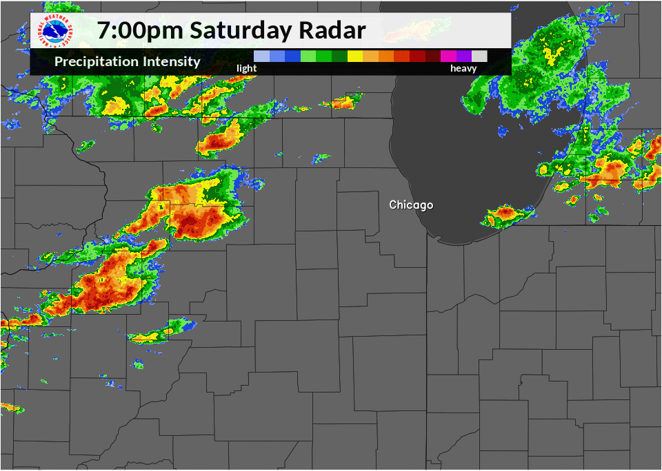 |
| Radar Loop from June 17, 2017 |
Storm Reports
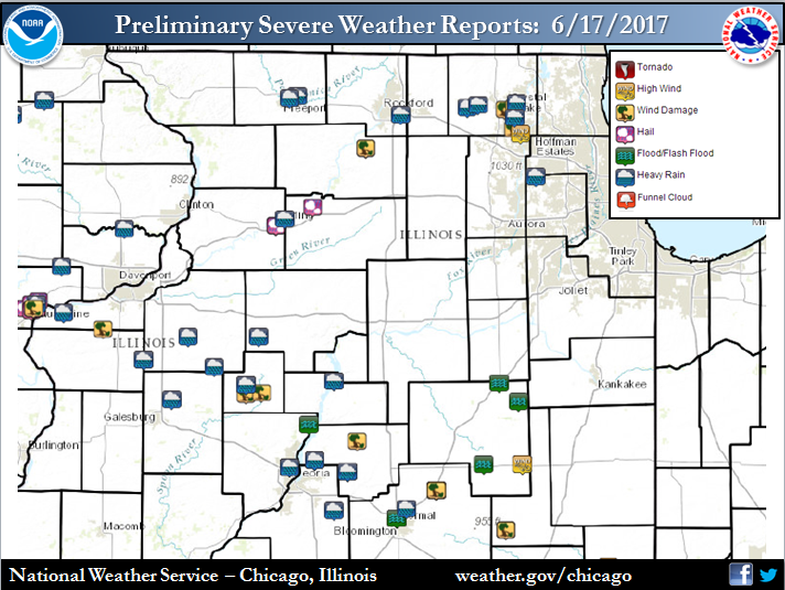
PRELIMINARY LOCAL STORM REPORT...SUMMARY
NATIONAL WEATHER SERVICE CHICAGO/ROMEOVILLE IL
1142 AM CDT SUN JUN 18 2017

..TIME...   ...EVENT...      ...CITY LOCATION...     ...LAT.LON...
..DATE...   ....MAG....      ..COUNTY LOCATION..ST.. ...SOURCE....
            ..REMARKS..

0418 PM     HAIL             DIXON                   41.85N 89.48W
06/17/2017  M0.25 INCH       LEE                IL   TRAINED SPOTTER

            NEAR I-88

0433 PM     TSTM WND DMG     STILLMAN VALLEY         42.10N 89.18W
06/17/2017                   OGLE               IL   EMERGENCY MNGR

            EVENT OCCURRED IN THE 6000 BLOCK OF STILLMAN RD.
            COMMERCIAL SEED BUILDING APPROXIMATELY 40 FEET BY 80 FEET
            DAMAGED. PROPANE TANK MOVED. TWO MOBILE HOME PARKS HAVE
            DAMAGE TO TREES AND POWER LINES.

0439 PM     HEAVY RAIN       BARTLETT                41.98N 88.21W
06/17/2017  M1.03 INCH       DUPAGE             IL   PUBLIC

            0.72 INCHES OF RAIN FELL IN 15 MINUTES

0455 PM     HEAVY RAIN       6 E HARWOOD HEIGHTS     41.96N 87.70W
06/17/2017  M0.68 INCH       COOK               IL   COCORAHS

            RAIN FELL IN 15 MINUTES

0735 PM     HEAVY RAIN       5 ESE ROCKFORD          42.24N 88.98W
06/17/2017  M0.75 INCH       WINNEBAGO          IL   COCORAHS

            0.75 INCHES OF RAINFALL MEASURED IN THE LAST 25 MINUTES.
            30 MPH WIND GUSTS ALSO RECORDED

0816 PM     HEAVY RAIN       1 N MARENGO             42.27N 88.60W
06/17/2017  M1.03 INCH       MCHENRY            IL   PUBLIC

            1.03 INCHES OF RAIN MEASURED BETWEEN 742P AND 814P CDT

0818 PM     TSTM WND DMG     4 SSE WOODSTOCK         42.26N 88.39W
06/17/2017                   MCHENRY            IL   UTILITY COMPANY

            TREES AND POWERLINES DOWNED

0824 PM     TSTM WND DMG     5 SSW MCHENRY           42.27N 88.33W
06/17/2017                   MCHENRY            IL   UTILITY COMPANY

            TREES AND POWERLINES DOWNED

0826 PM     TSTM WND DMG     2 WNW ALGONQUIN         42.18N 88.34W
06/17/2017                   MCHENRY            IL   UTILITY COMPANY

            TREES DOWN ON POWERLINES

0829 PM     TSTM WND GST     ALGONQUIN               42.16N 88.30W
06/17/2017  E60.00 MPH       MCHENRY            IL   PUBLIC

            REPORT RELAYED VIA TWITTER. LOCATION NEAR BORDER OF
            ALGONQUIN AND LAKE IN THE HILLS.

0847 PM     HEAVY RAIN       4 SSW MCHENRY           42.29N 88.32W
06/17/2017  M1.25 INCH       MCHENRY            IL   TRAINED SPOTTER

            MEASURED 1.25 INCHES OF RAIN IN THE LAST 30 MINUTES IN
            THE AREA OF WALKUP AND CRYSTAL SPRINGS RD.

0853 PM     HEAVY RAIN       CRYSTAL LAKE            42.23N 88.33W
06/17/2017  M1.40 INCH       MCHENRY            IL   CO-OP OBSERVER

            24 HOUR RAIN TOTAL

0854 PM     HEAVY RAIN       3 N UNION               42.28N 88.54W
06/17/2017  M1.25 INCH       MCHENRY            IL   PUBLIC

            1.25 INCHES OF RAIN MEASURED IN A 30 MINUTE PERIOD

0950 PM     NON-TSTM WND GST CHATSWORTH              40.75N 88.29W
06/17/2017  E40.00 MPH       LIVINGSTON         IL   CO-OP OBSERVER

            1 INCH OF RAIN MEASURED IN A FEW MINUTES ALONG WITH THE
            40 MPH WIND GUST.

0950 PM     TSTM WND DMG     GIBSON CITY             40.47N 88.38W
06/17/2017                   FORD               IL   EMERGENCY MNGR

            A FEW TREES DOWN IN TOWN...INCLUDING ONE BLOCKING THE
            ROAD AT CHURCH AND 8TH. MANY SMALL BRANCHES DOWN. TIME
            ESTIMATED.

0950 PM     TSTM WND DMG     GIBSON CITY             40.47N 88.38W
06/17/2017                   FORD               IL   EMERGENCY MNGR

            LOTS OF TREES DOWN AND SOME POWERLINES DOWN AROUND TOWN.
            THE WORST OF THE DAMAGE OS CONCENTRATED BETWEEN 8TH AND
            14TH STREET...EAST OF SANGAMON. REPORT RELAYED FROM
            GIBSON CITY MAYOR. TIME ESTIMATED BY RADAR.

0245 AM     FLASH FLOOD      CAMPUS                  41.02N 88.31W
06/18/2017                   LIVINGSTON         IL   TRAINED SPOTTER

            MANY ROADS ACROSS NORTHEAST LIVINGSTON COUNTY REPORTED
            FLOODED, INCLUDING IN THE CAMPUS AREA.

0330 AM     FLASH FLOOD      DWIGHT                  41.10N 88.42W
06/18/2017                   LIVINGSTON         IL   LAW ENFORCEMENT

            SEVERAL STREETS FLOODED IN TOWN. TIME ESTIMATED BASED ON
            RADAR.

0752 AM     FLOOD            FAIRBURY                40.75N 88.51W
06/18/2017                   LIVINGSTON         IL   PUBLIC

            INDIAN CREEK GOLF AND COUNTRY CLUB


&&

$$
Rain Reports
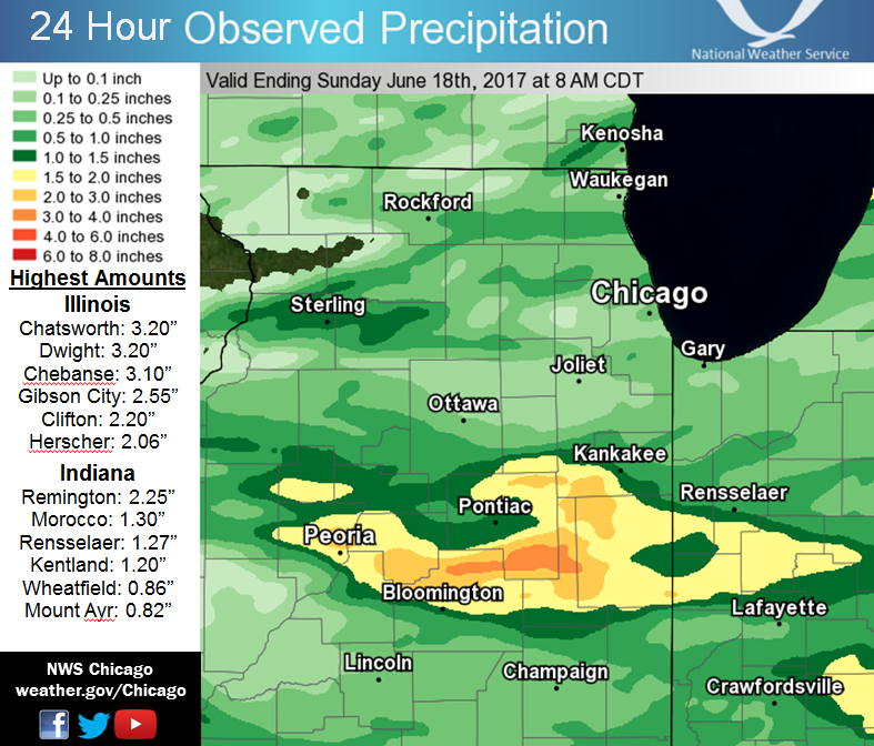
Public Information Statement
National Weather Service Chicago IL
1018 AM CDT Sun Jun 18 2017

...Morning Rainfall Roundup...

   The following are rain amounts for the previous 24-hours
   as measured in the morning by NWS Cooperative Observers
   and CoCoRaHS observers.
   Observations are usually taken between 6 AND 8 AM.

   24-hour rainfall amounts
       for Sunday(06/18/17)...


Illinois                                       Rain
  Location (County):                           fall (inches)

  Chatsworth (Livingston)......................3.20
  Dwight (Livingston)..........................3.20
  Chebanse (Kankakee)..........................3.10
  Gibson 6NE (Ford)............................2.55
  Emington 2SSE (Livingston)...................2.25
  Clifton 1NW (Iroquois).......................2.20
  Herscher 3E (Kankakee).......................2.06
  Ashton (Lee).................................2.00
  Ashkum 5.6E (Iroquois).......................1.99
  Buckley (Iroquois)...........................1.95
  Streator 4ENE (La Salle).....................1.88
  Watseka 6.9WNW (Iroquois)....................1.83
  Cissna Park 1S (Iroquois)....................1.74
  Gibson 2SW (Ford)............................1.68
  Dwight 4NNW (Grundy).........................1.67
  Streator (Livingston)........................1.63
  Gibson 3WNW (Ford)...........................1.60
  Streator 1WSW (La Salle).....................1.49
  Bonfield 4WSW (Kankakee).....................1.46
  Pontiac (Livingston).........................1.44
  Pontiac 1SE (Livingston).....................1.42
  Dixon 2SW (Lee)..............................1.34
  Paxton (Ford)................................1.24
  Mundelein (Lake).............................1.23
  Belvidere 2NW (Boone)........................1.22
  Woodstock 4SW (McHenry)......................1.17
  Sterling 4NE (Lee)...........................1.16
  Mundelein (Lake).............................1.12
  Amboy (Lee)..................................1.02
  Ravenswood Manor (Cook)......................1.00
  Bonfield 4NNE (Kankakee).....................0.98
  Momence 6SSW (Kankakee)......................0.96
  Mundelein 2WNW (Lake)........................0.96
  St. Charles 6NW (Kane).......................0.95
  Lake in the Hills 2.5W (McHenry).............0.94
  Crystal Lake 1WSW (McHenry)..................0.93
  Lake Zurich 1N (Lake)........................0.91
  Wilmington 3SE (Will)........................0.84
  La Salle (La Salle)..........................0.83
  Kankakee 4WNW (Kankakee).....................0.82
  Crystal Lake 5ENE (McHenry)..................0.81
  Plano (Kendall)..............................0.79
  Woodstock 1SSW (McHenry).....................0.79
  Bourbonnais (Kankakee).......................0.77
  Peru 1ENE (La Salle).........................0.77
  Elgin 8WSW (Kane)............................0.75
  Rochelle (Ogle)..............................0.74
  Cary (McHenry)...............................0.73
  Rockford 3NE (Winnebago).....................0.73
  Mchenry (McHenry)............................0.73
  Lincolnshire 1N (Lake).......................0.71
  Highwood 1S (Lake)...........................0.68
  Arlington Heights 3SSW (Cook)................0.64
  Winthrop Harbor (Lake).......................0.64
  Botanic Gardens (Cook).......................0.63
  Rochelle (Ogle)..............................0.62
  Glencoe (Cook)...............................0.61
  Burnham-hegewisch 2NNW (Cook)................0.57
  Dixon 3NNW (Lee).............................0.57
  Lily Lake 2E (Kane)..........................0.56
  Rockford 1NW (Winnebago).....................0.56
  Rockford 2ENE (Winnebago)....................0.54
  Alsip (Cook).................................0.52
  Peru (La Salle)..............................0.52
  Chicago Ridge (Cook).........................0.51
  Winthrop Harbor 1SSW (Lake)..................0.51
  Oak Lawn 2SE (Cook)..........................0.50
  Manteno 2NW (Kankakee).......................0.50
  Steward (Lee)................................0.50
  Oak Lawn (Cook)..............................0.49
  Algonquin 1N (McHenry).......................0.49
  Mazon 0.5ENE (Grundy)........................0.48
  Lakemoor 2SE (Lake)..........................0.44
  Beecher 3SSE (Will)..........................0.44
  Midlothian (Cook)............................0.43
  Palos Park 1SW (Cook)........................0.43
  Somonauk 2NE (De Kalb).......................0.43
  Zion (Lake)..................................0.42
  Peotone (Will)...............................0.42
  Midlothian (Cook)............................0.40
  Elk Grove Village 2WSW (Cook)................0.38
  Elgin (Kane).................................0.37
  Elgin 1S (Kane)..............................0.37
  De Kalb (De Kalb)............................0.36
  Lake Zurich (Lake)...........................0.36
  Palatine 1E (Cook)...........................0.35
  Rockford (Winnebago).........................0.34
  Park Ridge (Cook)............................0.33
  Aurora (Kane)................................0.32
  Buffalo Grove 2N (Lake)......................0.31
  Ohare (Cook).................................0.31
  Harwood Heights (Cook).......................0.30
  Seneca 2SSW (La Salle).......................0.30
  Arlington Heights 1SW (Cook).................0.29
  Momence (Kankakee)...........................0.29
  Elk Grove Village 1ESE (Cook)................0.27
  Sugar Grove 1ENE (Kane)......................0.27
  Wheeling (Cook)..............................0.27
  Worth (Cook).................................0.26
  Elgin 2W (Kane)..............................0.25
  Ottawa (La Salle)............................0.25
  Woodstock 5nw (McHenry)......................0.25
  Beecher 3ENE (Will)..........................0.24
  De Kalb 1SW (De Kalb)........................0.23
  Elmhurst 1ESE (Du Page)......................0.23
  Homer Glen 1ENE (Will).......................0.23
  Rockford 6S (Winnebago)......................0.23
  Hoffman Estates 5W (Cook)....................0.22
  Sugar Grove 1NE (Kane).......................0.22
  Carpentersville 1E (Kane)....................0.22
  Seneca 1NNE (La Salle).......................0.21
  Wonder Lake 1WNW (McHenry)...................0.21
  Naperville 4SSW (Will).......................0.21
  North Utica 6N (La Salle)....................0.20
  Elgin (Kane).................................0.19
  Darien (Du Page).............................0.19
  Aurora 4SE (Du Page).........................0.18
  Ottawa 1NW (La Salle)........................0.18
  Wonder Lake 1NE (McHenry)....................0.18
  Genoa (De Kalb)..............................0.17
  Aurora 4SE (Du Page).........................0.17
  Fox Lake 2SE (Lake)..........................0.17
  Ottawa 2N (La Salle).........................0.17
  Monee (Will).................................0.17
  Elburn (Kane)................................0.16
  Roscoe 2ESE (Winnebago)......................0.16
  Roscoe 2se (Winnebago).......................0.16
  Aurora (Kane)................................0.15
  Winnetka 1ESE (Cook).........................0.15
  Kingston 2WNW (De Kalb)......................0.15
  Elmhurst 2SE (Du Page).......................0.15
  Naperville 2ESE (Du Page)....................0.15
  Naperville 2SE (Du Page).....................0.15
  Coal City 3N (Grundy)........................0.15
  Riverwoods (Lake)............................0.15
  Lake Villa 2WSW (Lake).......................0.15
  Mendota (La Salle)...........................0.15
  Crete 3E (Will)..............................0.15
  Park Forest (Cook)...........................0.15
  Earlville 5NNE (De Kalb).....................0.14
  Elmhurst (Du Page)...........................0.14
  Geneva 1SSW (Kane)...........................0.14
  Sheridan 3SSE (La Salle).....................0.14
  Marseilles 5WNW (La Salle)...................0.14
  Lansing (Cook)...............................0.14
  Willow Springs (Cook)........................0.14
  Coal City 4NNW (Grundy)......................0.13
  Carbon Hill 3.1N (Grundy)....................0.13
  Waukegan 2E (Lake)...........................0.13
  Park Ridge 1WNW (Cook).......................0.12
  Oak Park 1SW (Cook)..........................0.12
  Naperville 1NW (Du Page).....................0.12
  Morris 6ESE (Grundy).........................0.12
  River Forest 1SSE (Cook).....................0.11
  Park Forest 1SW (Cook).......................0.11
  Flossmoor 1ESE (Cook)........................0.11
  Homewood (Cook)..............................0.11
  Park Forest 1NNE (Cook)......................0.11
  Batavia 2WNW (Kane)..........................0.11
  Winnebago 1SE (Winnebago)....................0.11
  Mendota (La Salle)...........................0.11
  Waukegan (Lake)..............................0.11
  Oak Park 2S (Cook)...........................0.10
  Flossmoor (Cook).............................0.10
  Oak Park 1NNE (Cook).........................0.10
  Morris 5NNW (Grundy).........................0.10
  Manhattan 5ENE (Will)........................0.10
  New Lenox 4SE (Will).........................0.10
  Wilmington 6NW (Will)........................0.10
  Joliet Lock/dam (Will).......................0.10
  Manhattan (Will).............................0.10
  Burr Ridge 2SW (Du Page).....................0.09
  Batavia 1WSW (Kane)..........................0.09
  New Lenox 2SE (Will).........................0.09
  New Lenox 3ENE (Will)........................0.09
  Manhattan 2SE (Will).........................0.09
  Mokena 1W (Will).............................0.08
  Channahon 2SSE (Will)........................0.08
  Morris (Grundy)..............................0.07
  West Chicago (Du Page).......................0.07
  Chicago 6ESE (Cook)..........................0.07
  Chicago 6NNE (Cook)..........................0.07
  Glen Ellyn 2SSE (Du Page)....................0.07
  Lisle (Du Page)..............................0.07
  Geneva 4WSW (Kane)...........................0.07
  Elwood 5NE (Will)............................0.07
  Lockport 1SE (Will)..........................0.07
  New Lenox 3E (Will)..........................0.07
  Midway Coop (Cook)...........................0.07
  Batavia (Kane)...............................0.06
  Capron (Boone)...............................0.06
  Bridgeview 1NNW (Cook).......................0.06
  Plainfield 5SW (Kendall).....................0.06
  Joliet 2n (Will).............................0.06
  Plainfield (Will)............................0.06
  Westmont (Du Page)...........................0.06
  La Grange Park 1SSW (Cook)...................0.05
  Downers Grove 0.4NNE (Du Page)...............0.05
  Oswego 5SSE (Kendall)........................0.05
  Romeoville (Will)............................0.05
  Countryside 1ENE (Cook)......................0.04
  Glen Ellyn 1WSW (Du Page)....................0.04
  Sublette (Lee)...............................0.04
  Joliet (Will)................................0.04
  Dekalb (De Kalb).............................0.03
  Romeoville (Will)............................0.03
  Midway (Cook)................................0.03
  Hebron (McHenry).............................0.02
  Lansing (Cook)...............................0.02
  Wheaton 2NNE (Du Page).......................0.02
  Carol Stream (Du Page).......................0.02
  Byron 3N (Ogle)..............................0.02

Indiana                                        Rain
  Location (County):                           fall (inches)

  Remington (Jasper)...........................2.25
  Remington (Jasper)...........................1.98
  Morocco (Newton).............................1.30
  Rensselaer 2SSW (Jasper).....................1.27
  Kentland 2SSE (Newton).......................1.20
  Rensselaer (Jasper)..........................1.09
  Wheatfield 5W (Jasper).......................0.86
  Mount Ayr 2NNE (Newton)......................0.82
  De Motte 1SSW (Jasper).......................0.80
  De Motte 1NNW (Jasper).......................0.70
  De Motte 4SW (Jasper)........................0.60
  Lake Village (Newton)........................0.60
  Rensselaer 4N (Jasper).......................0.48
  (w9opr)Wheatfield 1ENE (Jasper)..............0.38
  Wheatfield 4WSW (Jasper).....................0.32
  Hebron 4NE (Porter)..........................0.31
  Lowell (Lake)................................0.31
  Valparaiso 3WSW (Porter).....................0.29
  (kb9f)Valparaiso 4S (Porter).................0.28
  Lakes Of The Four Seasons 2NNE (Porter)......0.26
  Valparaiso 2WSW (Porter).....................0.25
  Hammond 1SSW (Lake)..........................0.23
  Valparaiso 1SE (Porter)......................0.23
  Valparaiso 6SSW (Porter).....................0.23
  Valparaiso 7WSW (Porter).....................0.23
  Rensselaer 10NNE (Jasper)....................0.21
  Crown Point 2WSW (Lake)......................0.16
  (w9mal)Merrillville 2NNW (Lake)..............0.15
  Highland 1ESE (Lake).........................0.15
  Hobart 1E (Lake).............................0.15
  Munster 2NNW (Lake)..........................0.14
  Valparaiso 4SW (Porter)......................0.14
  Valparaiso (Porter)..........................0.13
  Schererville 1E (Lake).......................0.12
  Griffith 1N (Lake)...........................0.12
  Valparaiso 1NNW (Porter).....................0.12
  Crown Point (Lake)...........................0.11
  Crown Point 1N (Lake)........................0.11
  Hobart 1NNW (Lake)...........................0.11
  Valparaiso 2WNW (Porter).....................0.10
  Valparaiso 2NW (Porter)......................0.10
  Portage 3E (Porter)..........................0.10
  Portage 1ESE (Porter)........................0.09
  Gary 5ENE (Lake).............................0.07
  Valparaiso 6NW (Porter)......................0.06

$$
 |
Media use of NWS Web News Stories is encouraged! Please acknowledge the NWS as the source of any news information accessed from this site. |
|

