An atmospheric river will continue to bring gusty winds, moderate to heavy rainfall, and potential flooding to southern California and the southern Great Basin through Sunday. Periods of heavy snow will continue as well above 7,000 feet over the Sierra Nevada mountains associated with this atmospheric river. Read More >
Overview
|
Fast Facts:
|
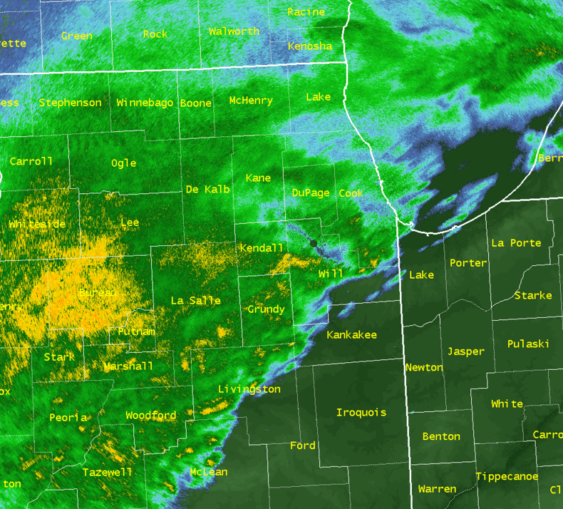
 Radar Loop from Saturday, April 29 - Sunday April, 30 |
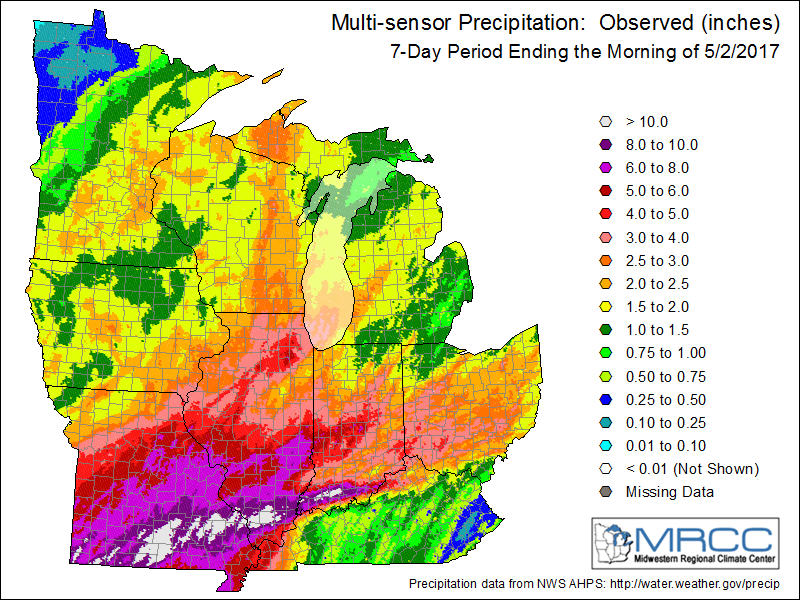
Rainfall Totals
 |
 |
||||||
| April 29-30 Rainfall Totals | April 26-May 2 Rainfall Totals |
ublic Information Statement
National Weather Service Chicago IL
443 PM CDT Mon May 1 2017 /543 PM EDT Mon May 1 2017/

...April 29-30 Highest Rainfall Totals...

The following are rain amounts for the previous 24-hours
as measured in the morning by NWS Cooperative Observers
and CoCoRaHS observers. Observations are usually taken
between 6 AND 8 AM. These totals below are 48-hour rainfall
amounts.

                            Rain
Location (County):          fall (inches)
-----------------------------------------
Minooka (Grundy)              5.42
La Salle (La Salle)           5.34
Oglesby 1ESE (La Salle)       5.12
Ottawa (La Salle)             4.90
Streator 1WSW (La Salle)      4.68
Plainfield 2SSE (Will)        4.64
Streator 4ENE (La Salle)      4.59
Carbon Hill 3.1N (Grundy)     4.57
Ottawa 2N (La Salle)          4.56
Morris 6ESE (Grundy)          4.55
Naperville 1NW (Du Page)      4.47
Carol Stream (Du Page)        4.40
Ottawa 1NW (La Salle)         4.37
Plainfield (Will)             4.31
Aurora 4NE (Du Page)          4.29
Lockport 1SE (Will)           4.28
Plainfield 3SE (Will)         4.22
Joliet 2N (Will)              4.21
Plainfield 5SW (Kendall)      4.19
Glen Ellyn 1NNW (Du Page)     4.15
Marseilles (La Salle)         4.07
Lincolnwood 3E (Cook)         4.06
Mazon 0.5ENE (Grundy)         4.02
North Aurora 2NE (Kane,IL)    4.01
St. Charles (Kane)            3.98
Channahon 1NNE (Will)         3.95
Rogers Park 2SW (Cook)        3.95
Wilmington 6NW (Will)         3.92
Marseilles 5WNW (La Salle)    3.92
Seneca 2SSW (La Salle)        3.88
Evanston 1N (Cook,IL)         3.88
Dwight 4NNW (Grundy)          3.87
Batavia 1WSW (Kane)           3.87
Oswego 5SSE (Kendall)         3.86
Somonauk 2NE (De Kalb)        3.86
Elk Grove Village 2WSW (Cook) 3.85
Montgomery 1SSE (Kendall)     3.83
Sheridan 3SSE (La Salle)      3.83
Villa Park 1NW (Du Page)      3.83
Aurora 4SE (Du Page)          3.81
Ravenswood Manor (Cook)       3.81
Chicago 6ESE (Cook)           3.81
Yorkville 2SE (Kendall)       3.80
Coal City 3N (Grundy)         3.78
Batavia 2WNW (Kane)           3.78


The following are official NWS rainfall amounts,
most of which are from Automated Surface Observing
Systems (ASOS). These are 48-hour rainfall amounts.

                                    Rain
Location (County):                  fall (inches)
-------------------------------------------------
​Romeoville (Will)                   3.56
Chicago O`Hare (Cook)               3.27
DuPage Airport (DuPage)             3.12
Sugar Grove - Aurora Airport (Kane) 3.02
Chicago Midway (Cook)               2.93
Wheeling (Cook)                     2.85
Rockford Airport (Winnebago)        1.75
Valparaiso (Porter)                 1.28


$$

MTF
Additional Rainfall
Public Information Statement National Weather Service Chicago IL 904 AM CDT Mon May 1 2017 /1004 AM EDT Mon May 1 2017/ ...April 29-30 Rainfall Reports... Observations are collected from a variety of sources with varying equipment and exposures. We thank all volunteer weather observers for their dedication. Not all data listed are considered official. ...Illinois... Location Amount Time/Date Provider --------------------------------------------------------------- ...Boone County... Capron 1.96 in 0700 AM 05/01 COCORAHS Belvidere 1.45 in 0843 AM 05/01 CWOP 3 E Roscoe 1.42 in 0845 AM 05/01 CWOP ...Cook County... Lemont 4.18 in 0800 AM 05/01 COCORAHS Rogers Park 1.5 SW 3.95 in 0700 AM 05/01 COCORAHS Hyde Park 3.81 in 0600 AM 05/01 COCORAHS 1 S La Grange 3.76 in 0700 AM 05/01 COCORAHS Rolling Meadows 0.9 ESE 3.74 in 0700 AM 05/01 COCORAHS Worth 3.74 in 0715 AM 05/01 COCORAHS 1 WSW Rogers Park 3.68 in 0700 AM 05/01 COCORAHS Chicago Ridge 3.63 in 0700 AM 05/01 COCORAHS Midway Coop 3.59 in 0700 AM 05/01 UCOOP Chicago 6.4 NNE 3.56 in 0700 AM 05/01 COCORAHS Oak Lawn 3.53 in 0755 AM 05/01 COCORAHS 1 S Hometown 3.52 in 0840 AM 05/01 CWOP Harwood Heights 3.50 in 0700 AM 05/01 COCORAHS 1 SW Rogers Park 3.50 in 0844 AM 05/01 CWOP Arlington Heights 2.6 SSW 3.42 in 0700 AM 05/01 COCORAHS 2 SSE East Dundee 3.41 in 0750 AM 05/01 COCORAHS Brookfield 3.41 in 0700 AM 05/01 COCORAHS Elk Grove Village 0.6 ESE 3.38 in 0600 AM 05/01 COCORAHS 1 NNW Norridge 3.37 in 0831 AM 05/01 CWOP Midlothian 3.36 in 0745 AM 05/01 HADS Midlothian 3.35 in 0800 AM 05/01 COCORAHS 1 NNE Bartlett 3.31 in 0832 AM 05/01 CWOP 1 W Chicago 3.30 in 0832 AM 05/01 CWOP 1 WSW Lakeview 3.30 in 0828 AM 05/01 CWOP Chicago O`Hare 3.28 in 0651 AM 05/01 ASOS Chicago Botanical Garden 3.26 in 0800 AM 05/01 COOP Riverside 3.21 in 0745 AM 05/01 USARMY-COE Park Ridge 3.14 in 0700 AM 05/01 COCORAHS 1 ENE Merrionette Park 3.12 in 0841 AM 05/01 CWOP La Grange Park 3.01 in 0700 AM 05/01 COCORAHS Golf 2.99 in 0848 AM 05/01 CWOP Chicago Midway 2.99 in 0653 AM 05/01 ASOS Glencoe 0.1 NW 2.91 in 0700 AM 05/01 COCORAHS Palatine 2.88 in 0841 AM 05/01 CWOP Indian Head Park 2.87 in 0843 AM 05/01 CWOP Wheeling - Chi Exec Airport 2.86 in 0652 AM 05/01 ASOS 1 E Palatine 2.82 in 0650 AM 05/01 COCORAHS 1 NNW Burnham 2.82 in 0700 AM 05/01 COCORAHS Barrington 2.80 in 0800 AM 05/01 COOP 1 SW Palatine 2.76 in 0846 AM 05/01 CWOP 1 S Niles 2.72 in 0837 AM 05/01 CWOP Rosemont 2.67 in 0826 AM 05/01 CWOP Lakeview 2.67 in 0842 AM 05/01 CWOP Flossmoor 1.2 ESE 2.62 in 0700 AM 05/01 COCORAHS 2 SW Meigs Field 2.61 in 0844 AM 05/01 CWOP 2 W Palos Park 2.59 in 0845 AM 05/01 CWOP Homewood 2.58 in 0700 AM 05/01 COCORAHS 1 SW Park Forest 2.53 in 0400 AM 05/01 COCORAHS Flossmoor 2.51 in 0700 AM 05/01 COCORAHS Navy Pier 2.49 in 0700 AM 05/01 COCORAHS 1 WNW Hickory Hills 2.47 in 0849 AM 05/01 CWOP Orland Park 2.46 in 0834 AM 05/01 CWOP Northbrook 2.38 in 0837 AM 05/01 CWOP Alsip 2.37 in 0700 AM 05/01 COCORAHS 1 ENE South Barrington 2.36 in 0832 AM 05/01 CWOP 1 WNW Burnham 2.24 in 0800 AM 05/01 USARMY-COE Park Forest 0.8 NNE 1.97 in 0700 AM 05/01 COCORAHS Chicago Heights 1.90 in 0800 AM 05/01 HADS 1 ESE Glenwood 1.72 in 0846 AM 05/01 CWOP Lansing Airport 1.60 in 0655 AM 05/01 AWOS ...De Kalb County... Somonauk 3.87 in 0700 AM 05/01 COCORAHS 1 W Sandwich 3.86 in 0500 AM 05/01 COCORAHS 5 NNE Shabbona 2.66 in 0800 AM 05/01 GOES Cortland 0.3 SSW 2.59 in 0630 AM 05/01 COCORAHS Il Shabbona 5 NNE 2.42 in 0700 AM 05/01 GOES De Kalb 2.30 in 0700 AM 05/01 COCORAHS De Kalb 2.30 in 0700 AM 05/01 COCORAHS De Kalb 2.23 in 0700 AM 05/01 COOP De Kalb Airport 2.17 in 0655 AM 05/01 AWOS 2 N Sycamore 2.03 in 0843 AM 05/01 CWOP 2 WNW Kingston 1.73 in 0700 AM 05/01 COCORAHS Sycamore 1.46 in 0841 AM 05/01 CWOP 1 WNW Genoa 1.19 in 0831 AM 05/01 CWOP ...DuPage County... Carol Stream 0.3 SSE 4.40 in 0645 AM 05/01 COCORAHS 1 WNW Glen Ellyn 4.05 in 0700 AM 05/01 COCORAHS 1 NW Villa Park 3.83 in 0530 AM 05/01 COCORAHS Downers Grove 3.83 in 0659 AM 05/01 COCORAHS 3 ESE Aurora 3.81 in 0700 AM 05/01 COCORAHS 1 SE Naperville 3.80 in 0844 AM 05/01 CWOP Naperville 3.74 in 0841 AM 05/01 CWOP Willow Springs 3.69 in 0800 AM 05/01 COOP Warrenville 3.69 in 0825 AM 05/01 HADS Lisle 0.5 WSW 3.66 in 0700 AM 05/01 COCORAHS 2 ESE Naperville 3.63 in 0700 AM 05/01 COCORAHS 2 SSE Darien 3.58 in 0800 AM 05/01 HADS Lisle 3.56 in 0700 AM 05/01 COCORAHS 2 SSE West Chicago 3.53 in 0820 AM 05/01 HADS Naperville 2.5 ESE 3.50 in 0700 AM 05/01 COCORAHS 3 SE Wheaton 3.45 in 0700 AM 05/01 COOP Elmhurst 2.0 SE 3.44 in 0700 AM 05/01 COCORAHS 3 ESE Aurora 3.42 in 0700 AM 05/01 COCORAHS 1 WNW Wheaton 3.39 in 0842 AM 05/01 CWOP 2 NNW Woodridge 3.28 in 0844 AM 05/01 CWOP Westmont 3.13 in 0844 AM 05/01 CWOP Dupage Airport 3.13 in 0652 AM 05/01 ASOS 1 ESE Darien 3.11 in 0730 AM 05/01 COCORAHS 1 E West Chicago 3.11 in 0844 AM 05/01 CWOP Dupage Airport 3.10 in 1200 AM 05/01 UCOOP 1 W Lisle 3.07 in 0844 AM 05/01 CWOP 1 NNW Woodridge 2.95 in 0837 AM 05/01 CWOP Oakbrook Terrace 2.89 in 0815 AM 05/01 HADS 1 SW Hanover Park 2.84 in 0815 AM 05/01 HADS 1 NE Oak Brook 2.70 in 0800 AM 05/01 HADS Westmont 2.66 in 0700 AM 05/01 UCOOP 1 WNW Glen Ellyn 1.81 in 0840 AM 05/01 CWOP 2 NW Bolingbrook 1.72 in 0843 AM 05/01 CWOP ...Ford County... 3 WSW Melvin 1.73 in 0700 AM 05/01 COCORAHS 2 SW Gibson City 1.67 in 0700 AM 05/01 COCORAHS 3 WNW Gibson City 1.35 in 0700 AM 05/01 COCORAHS ...Grundy County... Coal City 4NNW 4.57 in 0700 AM 05/01 UCOOP 3 N Carbon Hill 4.57 in 0700 AM 05/01 COCORAHS 2 NNW Carbon Hill 4.55 in 0700 AM 05/01 COCORAHS 1 NW Morris 4.42 in 0800 AM 05/01 COOP 3 SSW Minooka 4.12 in 0800 AM 05/01 HADS Mazon 4.02 in 0700 AM 05/01 COCORAHS 4 NNW Dwight 3.87 in 0700 AM 05/01 COCORAHS Morris Airport 3.73 in 0655 AM 05/01 AWOS 4 NNW Coal City 3.04 in 0840 AM 05/01 CWOP ...Iroquois County... Buckley 0.2 SSE 1.92 in 0800 AM 05/01 COCORAHS Clifton 1.77 in 0700 AM 05/01 COCORAHS Milford 1.74 in 0845 AM 05/01 CWOP 5 E Ashkum 1.50 in 0600 AM 05/01 COCORAHS 1 N Crescent City 1.36 in 0600 AM 05/01 COCORAHS ...Kane County... 1 WSW North Aurora 4.67 in 0831 AM 05/01 CWOP Aurora Wtr Plnt - Coop 4.11 in 0700 AM 05/01 COOP Batavia 3.87 in 0600 AM 05/01 COCORAHS 1 WNW Batavia 3.78 in 0700 AM 05/01 COCORAHS 1 NE Elgin 3.60 in 0700 AM 05/01 COCORAHS Elgin 3.57 in 0800 AM 05/01 UCOOP Elgin 3.57 in 0800 AM 05/01 COCORAHS Sugar Grove 3.36 in 0700 AM 05/01 COCORAHS Elgin - Coop 3.26 in 0700 AM 05/01 COOP Batavia 3.16 in 0832 AM 05/01 CWOP Sugar Grove - Aurora Airport 3.02 in 0652 AM 05/01 ASOS Carpentersville 3.00 in 0700 AM 05/01 COCORAHS 3 WSW Geneva 2.97 in 0836 AM 05/01 CWOP Sleepy Hollow 2.96 in 0730 AM 05/01 COCORAHS 1 N Elburn 2.92 in 0845 AM 05/01 CWOP 4 W South Elgin 2.83 in 0700 AM 05/01 COCORAHS Elburn 2.81 in 0600 AM 05/01 COCORAHS Elburn 2.81 in 0600 AM 05/01 COOP 2 WNW Montgomery 2.78 in 0830 AM 05/01 HADS 2 W Geneva 2.71 in 0842 AM 05/01 CWOP 2 W Elgin 2.70 in 0700 AM 05/01 COCORAHS Carpentersville 2.65 in 0841 AM 05/01 CWOP Elburn 2.62 in 0830 AM 05/01 CWOP 1 ENE Sugar Grove 2.52 in 0700 AM 05/01 COCORAHS 2 S Sleepy Hollow 2.41 in 0842 AM 05/01 CWOP Gilberts 2.21 in 0800 AM 05/01 COCORAHS Elburn 2.09 in 0840 AM 05/01 CWOP Hampshire 1.91 in 0833 AM 05/01 CWOP Elburn 1.85 in 0839 AM 05/01 CWOP 1 ESE Huntley 1.69 in 0835 AM 05/01 CWOP ...Kankakee County... 1 NE Union Hill 2.27 in 0700 AM 05/01 COCORAHS 1 ENE Bonfield 2.18 in 0836 AM 05/01 CWOP 3 NW Bourbonnais 1.53 in 0700 AM 05/01 COOP Chebanse 0.4 NNE 1.52 in 0600 AM 05/01 COCORAHS 1 NE Union Hill 1.51 in 0843 AM 05/01 CWOP 2 W Irwin 1.47 in 0700 AM 05/01 COCORAHS Grant Park 1.46 in 0836 AM 05/01 CWOP St Anne 1.32 in 0700 AM 05/01 COOP 2 NE Bradley 1.18 in 0843 AM 05/01 CWOP ...Kendall County... 4 W Plainfield 3.86 in 0700 AM 05/01 COCORAHS Oswego 3.85 in 0815 AM 05/01 HADS Boulder Hill 3.83 in 0700 AM 05/01 COCORAHS 3 SSE Oswego 3.35 in 0849 AM 05/01 CWOP Plano 3.16 in 0700 AM 05/01 COCORAHS 2 SSW Oswego 3.06 in 0845 AM 05/01 CWOP ...La Salle County... La Salle 5.34 in 0700 AM 05/01 COCORAHS 4 SW Ottawa 4.90 in 0756 AM 05/01 COOP Peru 4.74 in 0700 AM 05/01 COCORAHS Streator 1.3 WSW 4.68 in 0700 AM 05/01 COCORAHS 3 ENE Streator 4.59 in 0600 AM 05/01 COCORAHS 1 N Ottawa 4.56 in 0700 AM 05/01 COCORAHS Ottawa 4.21 in 0730 AM 05/01 HADS Marseilles Lock And Dam 4.07 in 0600 AM 05/01 COOP 1 W Streator 4.01 in 0847 AM 05/01 CWOP 1 W Marseilles 3.99 in 0800 AM 05/01 HADS 2 E Ottawa 3.92 in 0730 AM 05/01 COCORAHS Mendota 3.42 in 0730 AM 05/01 COCORAHS Earlville 3.35 in 0600 AM 05/01 COOP Peru Airport 3.18 in 0655 AM 05/01 AWOS 2 ENE Leonore 3.13 in 0745 AM 05/01 HADS 2 WSW Sheridan 3.02 in 0843 AM 05/01 CWOP ...Lake County... Lake Zurich 3.36 in 0700 AM 05/01 UCOOP Riverwoods 2.85 in 0700 AM 05/01 COCORAHS Bannockburn 2.84 in 0630 AM 05/01 COCORAHS 4 WSW Mundelein - Coop 2.76 in 0700 AM 05/01 COOP 1 N Buffalo Grove 2.76 in 0635 AM 05/01 COCORAHS Highwood 2.66 in 0700 AM 05/01 COCORAHS Lake Zurich 1.3 N 2.64 in 0600 AM 05/01 COCORAHS Lincolnshire 2.60 in 0800 AM 05/01 COCORAHS Gurnee 1.6 W 2.58 in 0700 AM 05/01 COCORAHS 1 E Waukegan 2.45 in 0700 AM 05/01 COCORAHS 2 E Gages Lake 2.35 in 0830 AM 05/01 HADS Winthrop Harbor 2.33 in 0717 AM 05/01 COCORAHS 1 W Buffalo Grove 2.32 in 0829 AM 05/01 CWOP 1 ESE Lakemoor 2.26 in 0634 AM 05/01 COCORAHS 1 NE Mettawa 2.04 in 0832 AM 05/01 CWOP 1 NW Barrington 2.02 in 0825 AM 05/01 CWOP 1 SE Grayslake 1.83 in 0844 AM 05/01 CWOP 1 N Lake Zurich 1.77 in 0832 AM 05/01 CWOP Deer Park 1.62 in 0843 AM 05/01 CWOP ...Lee County... 1 E Paw Paw 2.56 in 0700 AM 05/01 COOP Amboy 2.32 in 0800 AM 05/01 COOP Ashton 2.27 in 0700 AM 05/01 COCORAHS Steward 2.25 in 0700 AM 05/01 COOP 1 NW Dixon 1.92 in 0800 AM 05/01 COOP 2 SSW Rochelle 1.91 in 0845 AM 05/01 CWOP Dixon 1.87 in 0815 AM 05/01 HADS Sublette 1.85 in 0842 AM 05/01 CWOP 2 WNW Dixon 1.81 in 0841 AM 05/01 CWOP 1 WSW Dixon 1.78 in 0700 AM 05/01 COCORAHS ...Livingston County... City Water Works Within 2.82 in 0700 AM 05/01 COOP Dwight 2.59 in 0827 AM 05/01 CWOP Dwight 2.36 in 0826 AM 05/01 CWOP Pontiac 1.83 in 0745 AM 05/01 USARMY-COE Pontiac 1.78 in 0700 AM 05/01 COCORAHS Waterworks 1.43 in 0700 AM 05/01 COOP 1 WNW Campus 1.41 in 0830 AM 05/01 CWOP Chatsworth 1.15 in 0700 AM 05/01 COOP ...McHenry County... 1 SW Lake In The Hills 2.27 in 0845 AM 05/01 CWOP 1 W Algonquin 2.14 in 0845 AM 05/01 CWOP 1 NNW Woodstock 1.91 in 0850 AM 05/01 CWOP 1 W Crystal Lake 1.78 in 0700 AM 05/01 COCORAHS 1 SSE Lakewood 1.75 in 0500 AM 05/01 COCORAHS Wonder Lake 1.75 in 0700 AM 05/01 COCORAHS 2 ENE Woodstock 1.74 in 0800 AM 05/01 COCORAHS Woodstock 1.72 in 0840 AM 05/01 CWOP 3 NE Union 1.68 in 0800 AM 05/01 COCORAHS Hebron 1.66 in 0840 AM 05/01 HADS 1 NE Wonder Lake 1.62 in 0700 AM 05/01 COCORAHS 1 S Bull Valley 1.53 in 0841 AM 05/01 CWOP 1 ESE Lakewood 1.53 in 0840 AM 05/01 CWOP Spring Grove 1.53 in 0800 AM 05/01 USGS 1 NNE Wonder Lake 1.48 in 0841 AM 05/01 CWOP Harvard 1.41 in 0844 AM 05/01 CWOP 2 W Woodstock 1.39 in 0837 AM 05/01 CWOP ...Ogle County... 3 NNW Byron 2.14 in 0700 AM 05/01 COCORAHS Rochelle Airport 1.90 in 0655 AM 05/01 AWOS ...Will County... 2 WNW Crystal Lawns 4.64 in 0700 AM 05/01 COCORAHS 5 SW Naperville 4.50 in 0833 AM 05/01 CWOP 3 NE Plainfield 4.31 in 0700 AM 05/01 COOP 1 SE Lockport 4.28 in 0700 AM 05/01 COCORAHS 1 NW Crystal Lawns 4.22 in 0700 AM 05/01 COCORAHS Joliet 4.21 in 0700 AM 05/01 UCOOP 2 WSW Elwood 3.97 in 0800 AM 05/01 HADS 4 SSW Channahon 3.92 in 0700 AM 05/01 COCORAHS 2 N Shorewood 3.76 in 0844 AM 05/01 CWOP 3 N Plainfield 3.72 in 0829 AM 05/01 CWOP Manhattan 3.72 in 0800 AM 05/01 HADS Romeoville Wfo 3.57 in 0700 AM 05/01 UCOOP Homer Glen 3.48 in 0700 AM 05/01 COCORAHS 3 WNW Manhattan 3.47 in 0700 AM 05/01 COCORAHS Homer Glen 3.31 in 0630 AM 05/01 COCORAHS Homer Glen 3.27 in 0700 AM 05/01 COCORAHS 1 WSW Homer Glen 3.20 in 0800 AM 05/01 HADS 1 W Mokena 3.18 in 0700 AM 05/01 COCORAHS Joliet Airport 3.15 in 0655 AM 05/01 AWOS 1 ESE Mokena 3.13 in 0800 AM 05/01 HADS 3 NNE Wilmington 3.08 in 0805 AM 05/01 RAWS 4 SW Plainfield 3.05 in 0845 AM 05/01 CWOP 2 W Mokena 3.04 in 0815 AM 05/01 HADS 1 SE New Lenox 3.04 in 0700 AM 05/01 COCORAHS 1 SSW Crest Hill 3.03 in 0842 AM 05/01 CWOP 1 W Joliet 2.99 in 0600 AM 05/01 COCORAHS Manhattan 1.9 SE 2.92 in 0700 AM 05/01 COCORAHS 1 WNW Fairmont 2.91 in 0800 AM 05/01 HADS 4 ENE Manhattan 2.89 in 0800 AM 05/01 COCORAHS Manhattan 2.89 in 0800 AM 05/01 UCOOP 3 N Manhattan 2.81 in 0830 AM 05/01 CWOP 5 ENE Symerton 2.78 in 0800 AM 05/01 HADS Lakewood Shores 2.78 in 0630 AM 05/01 COCORAHS 2 SSW Plainfield 2.72 in 0843 AM 05/01 CWOP Rockdale 2.66 in 0800 AM 05/01 HADS Shorewood 2.60 in 0745 AM 05/01 USARMY-COE Lewis Airport, Romeoville 2.49 in 0655 AM 05/01 AWOS 3 N Manhattan 2.33 in 0841 AM 05/01 CWOP 3 NE Plainfield 2.03 in 0842 AM 05/01 CWOP Peotone 1.92 in 0600 AM 05/01 UCOOP Peotone 1.92 in 0600 AM 05/01 COCORAHS 2 E Crete 1.91 in 0700 AM 05/01 COCORAHS Frankfort 1.85 in 0845 AM 05/01 CWOP ...Winnebago County... 2 S Loves Park 1.98 in 0800 AM 05/01 COCORAHS Rockford 1.97 in 0652 AM 05/01 COCORAHS Rockford 1.87 in 0700 AM 05/01 COCORAHS Rockford Airport 1.78 in 0654 AM 05/01 ASOS 1 ESE Roscoe 1.67 in 0630 AM 05/01 COCORAHS Roscoe 1.67 in 0630 AM 05/01 COOP 3 ENE Roscoe 1.54 in 0842 AM 05/01 CWOP Rockton 1.52 in 0830 AM 05/01 HADS 2 ENE Rockford 1.48 in 0830 AM 05/01 CWOP Winnebago 1.33 in 0700 AM 05/01 COCORAHS 2 SW Pecatonica 1.30 in 0840 AM 05/01 CWOP 1 S Roscoe 1.22 in 0845 AM 05/01 CWOP 1 SE Winnebago 1.05 in 0842 AM 05/01 CWOP ...Indiana... Location Amount Time/Date Provider --------------------------------------------------------------- ...Benton County... 2 SSE Boswell 1.96 in 0800 AM 05/01 HADS Fowler 1.51 in 0836 AM 05/01 CWOP ...Jasper County... Collegeville 2.06 in 0600 AM 05/01 COCORAHS Rensselaer 1.98 in 0730 AM 05/01 UCOOP 1 E Rensselaer 1.96 in 0830 AM 05/01 HADS Rensselaer 5.2 NW 1.87 in 0600 AM 05/01 COCORAHS 1 ENE Wheatfield 1.80 in 0530 AM 05/01 COCORAHS 4 WSW De Motte 1.74 in 0640 AM 05/01 COCORAHS 4 ESE De Motte 1.67 in 0700 AM 05/01 COCORAHS 5 S De Motte 1.65 in 0700 AM 05/01 COCORAHS 3 E De Motte 1.59 in 0800 AM 05/01 COCORAHS ...Lake County... 3 N Lake Station 2.57 in 0700 AM 05/01 COCORAHS Cedar Lake 2.50 in 0844 AM 05/01 CWOP (w9mal)merrillville 2.0 NNW 2.45 in 0700 AM 05/01 COCORAHS 1 WSW Crown Point 2.35 in 0700 AM 05/01 COCORAHS Hammond 2.31 in 0700 AM 05/01 COCORAHS 2 NNE Griffith 2.13 in 0815 AM 05/01 HADS Highland 2.07 in 0700 AM 05/01 COCORAHS Dyer 2.06 in 0800 AM 05/01 HADS 1 N Griffith 1.94 in 0600 AM 05/01 COCORAHS Hobart 1.92 in 0830 AM 05/01 HADS Griffith 1.90 in 0834 AM 05/01 CWOP Waste Water Facility 1.82 in 0700 AM 05/01 COOP 1 E Schererville 1.80 in 0800 AM 05/01 COCORAHS 1 WNW Highland 1.46 in 0800 AM 05/01 HADS 3 NW De Motte 1.45 in 0843 AM 05/01 CWOP 1 NNW Munster 1.38 in 0140 AM 05/01 CWOP ...Newton County... 1 NNE Mount Ayr 1.84 in 0800 AM 05/01 COCORAHS 3 E Brook 1.76 in 0745 AM 05/01 USGS 2 NNW Remington 1.69 in 0600 AM 05/01 COOP Kentland 1.7 SSE 1.68 in 0700 AM 05/01 COCORAHS 1 N Morocco 1.63 in 0600 AM 05/01 COOP Lake Village 1.62 in 0800 AM 05/01 COOP ...Porter County... Wanatah 1.95 in 0700 AM 05/01 COOP Portage 1.92 in 0700 AM 05/01 COCORAHS 4 ENE Lakes Of The Four 1.84 in 0700 AM 05/01 COCORAHS 1 NE Lakes Of The Four 1.81 in 0700 AM 05/01 COCORAHS Valparaiso 1.71 in 0700 AM 05/01 COCORAHS Valparaiso 1.71 in 0700 AM 05/01 COCORAHS 4 SW Valparaiso 1.69 in 0600 AM 05/01 COCORAHS Valparaiso 1.63 in 0844 AM 05/01 CWOP Valparaiso Airport 1.46 in 0656 AM 05/01 ASOS 2 SW Valparaiso 1.43 in 0838 AM 05/01 CWOP Porter 1.33 in 0700 AM 05/01 COCORAHS 3 E Lakes Of The Four 1.24 in 0845 AM 05/01 CWOP $$ MTF
PRELIMINARY LOCAL STORM REPORT...SUMMARY
NATIONAL WEATHER SERVICE CHICAGO/ROMEOVILLE IL
924 AM CDT MON MAY 01 2017

..TIME...   ...EVENT...      ...CITY LOCATION...     ...LAT.LON...
..DATE...   ....MAG....      ..COUNTY LOCATION..ST.. ...SOURCE....
            ..REMARKS..

0700 AM     HEAVY RAIN       ROMEOVILLE              41.65N 88.09W
05/01/2017  M3.56 INCH       WILL               IL   OFFICIAL NWS OBS

            WEEKEND TOTAL.

0700 AM     HEAVY RAIN       WHEELING                42.13N 87.92W
05/01/2017  M2.85 INCH       COOK               IL   ASOS

            WEEKEND TOTAL.

0700 AM     HEAVY RAIN       ROSELLE                 41.98N 88.08W
05/01/2017  M3.17 INCH       DUPAGE             IL   PUBLIC

            WEEKEND TOTAL.

0700 AM     HEAVY RAIN       1 WSW NORTH AURORA      41.80N 88.35W
05/01/2017  M4.67 INCH       KANE               IL   MESONET

            WEEKEND TOTAL.

0700 AM     HEAVY RAIN       5 SW NAPERVILLE         41.76N 88.15W
05/01/2017  M4.50 INCH       DUPAGE             IL   MESONET

            WEEKEND TOTAL.

0700 AM     HEAVY RAIN       3 SSW MINOOKA           41.42N 88.28W
05/01/2017  M4.12 INCH       GRUNDY             IL   MESONET

            WEEKEND TOTAL.

0700 AM     HEAVY RAIN       OHARE AIRPORT           41.98N 87.90W
05/01/2017  M3.27 INCH       COOK               IL   ASOS

0700 AM     HEAVY RAIN       SUGAR GROVE             41.77N 88.46W
05/01/2017  M3.02 INCH       KANE               IL   ASOS

            WEEKEND TOTAL.

0700 AM     HEAVY RAIN       DUPAGE AIRPORT          41.92N 88.25W
05/01/2017  M3.12 INCH       DUPAGE             IL   ASOS

            WEEKEND TOTAL.

0700 AM     HEAVY RAIN       MIDWAY AIRPORT          41.78N 87.75W
05/01/2017  M2.93 INCH       COOK               IL   ASOS

            WEEKEND TOTAL.

0700 AM     HEAVY RAIN       ROCKFORD AIRPORT        42.20N 89.10W
05/01/2017  M1.75 INCH       WINNEBAGO          IL   ASOS

            WEEKEND TOTAL.

0700 AM     HEAVY RAIN       VALPARAISO              41.48N 87.05W
05/01/2017  M1.28 INCH       PORTER             IN   ASOS

            WEEKEND TOTAL.

0700 AM     HEAVY RAIN       OSWEGO                  41.70N 88.33W
05/01/2017  M3.87 INCH       KENDALL            IL   NWS EMPLOYEE

            WEEKEND TOTAL.

0630 AM     HEAVY RAIN       3 NNE PLAINFIELD        41.66N 88.18W
05/01/2017  M3.60 INCH       WILL               IL   COCORAHS

            72 HOUR TOTAL.

0600 AM     HEAVY RAIN       BONFIELD                41.15N 88.06W
05/01/2017  M2.02 INCH       KANKAKEE           IL   PUBLIC

            WEEKEND TOTAL.

0600 AM     HEAVY RAIN       1 ESE VALPARAISO        41.47N 87.03W
05/01/2017  M1.71 INCH       PORTER             IN   TRAINED SPOTTER

            WEEKEND TOTAL.

0600 AM     HEAVY RAIN       JOLIET                  41.53N 88.12W
05/01/2017  M4.21 INCH       WILL               IL   PUBLIC

            WEEKEND TOTAL.

0100 AM     HEAVY RAIN       3 SW MIDWAY AIRPORT     41.75N 87.79W
05/01/2017  M3.50 INCH       COOK               IL   CO-OP OBSERVER

            2 DAY STORM TOTAL THROUGH 1 AM.

0100 AM     HEAVY RAIN       OHARE AIRPORT           41.98N 87.90W
05/01/2017  M3.27 INCH       COOK               IL   OFFICIAL NWS OBS

            2 DAY STORM TOTAL THROUGH 1 AM. 1.02 INCHES IN THE PAST 6
            HOURS.

0100 AM     HEAVY RAIN       ROMEOVILLE              41.65N 88.09W
05/01/2017  M3.56 INCH       WILL               IL   OFFICIAL NWS OBS

            2 DAY STORM TOTAL THROUGH 1 AM. 0.5 INCHES IN THE PAST 6
            HOURS.

0100 AM     HEAVY RAIN       ROCKFORD AIRPORT        42.20N 89.10W
05/01/2017  M1.75 INCH       WINNEBAGO          IL   OFFICIAL NWS OBS

            2 DAY STORM TOTAL THROUGH 1 AM. 0.55 INCHES IN THE PAST 6
            HOURS.

0100 AM     HEAVY RAIN       HOFFMAN ESTATES         42.06N 88.14W
05/01/2017  M4.30 INCH       COOK               IL   TRAINED SPOTTER

            WEEKEND TOTAL.


&&

$$

MTF
Climate Facts
Rivers and Flooding
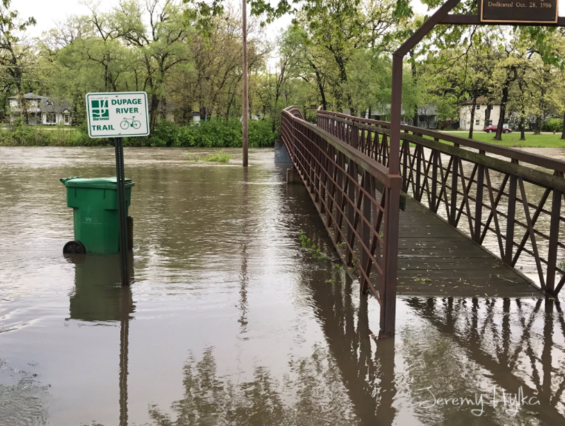
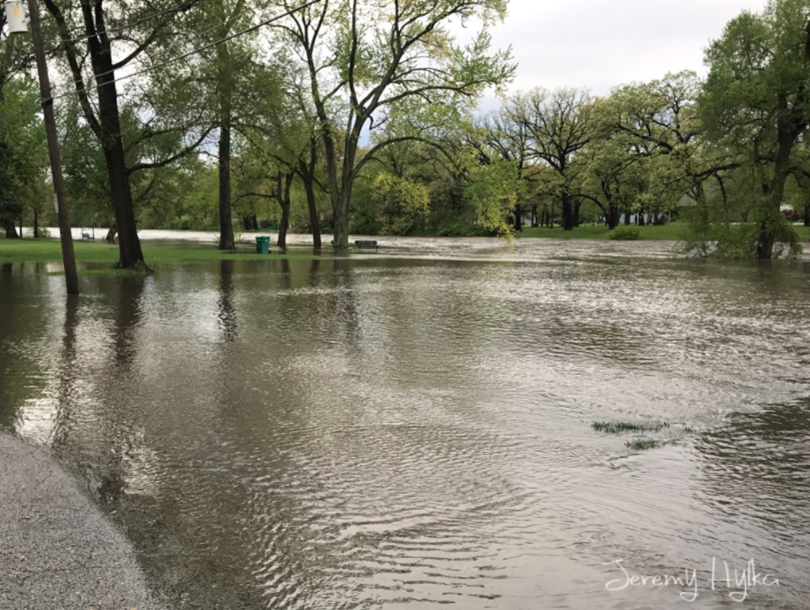
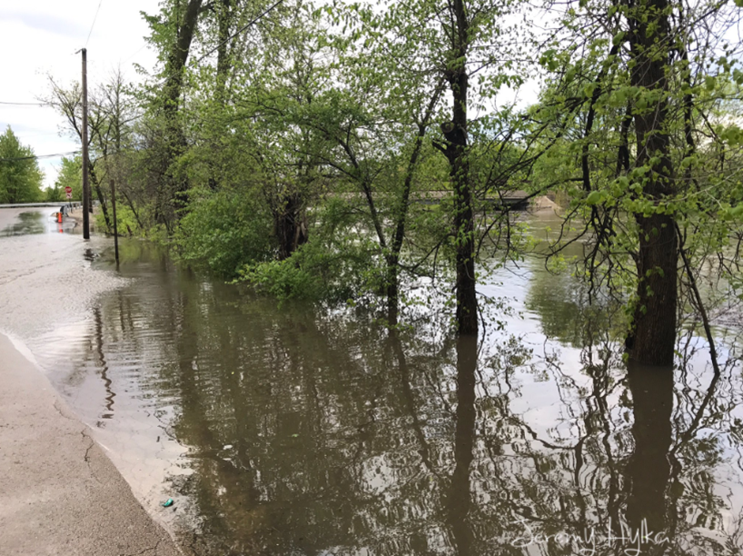
Photos
 |
 |
 |
||
| Along the DuPage River close to Illinois Route 59 and U.S. 52 in Shorewood. Courtesy of Joliet Weather Center. | Along the DuPage River close to Illinois Route 59 and U.S. 52 in Shorewood. Courtesy of Joliet Weather Center. | Along the DuPage River close to Caton Farm Rd and Lily Cache Rd in Joliet. Courtesy of Joliet Weather Center. |
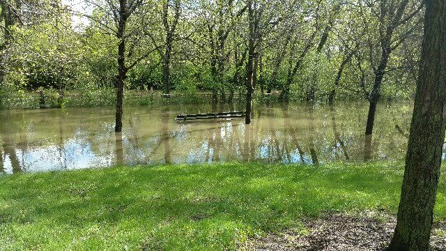 |
| Along the North Branch of the Chicago River, in Gompers Park, on the northwest side of Chicago. Courtesy of Chicago Office of Emergency Management. |
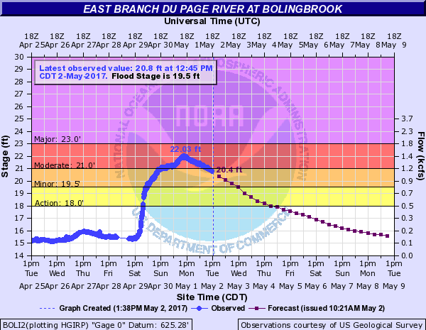
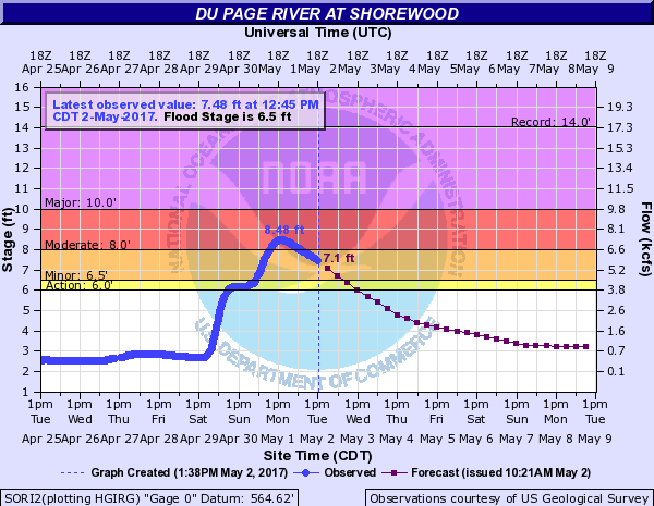
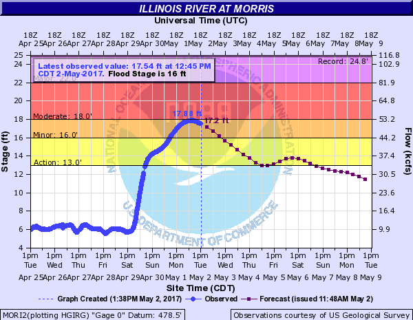
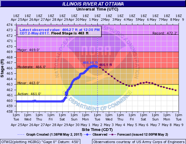
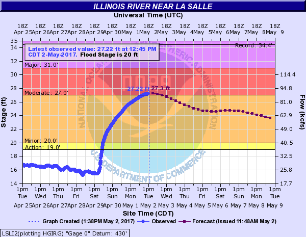
River Crests Observed
 |
 |
|
| DuPage River at Bolingbrook | DuPage River at Shorewood |
 |
 |
 |
||
| Illinois River at Morris | Illinois River at Ottawa | Illinois River at LaSalle |
April 29 Strong Winds
Public Information Statement
National Weather Service Chicago IL
854 AM CDT Sun Apr 30 2017 /954 AM EDT Sun Apr 30 2017/

...Highest Wind Gusts Saturday Evening...

The following is a listing of maximum wind gusts during mainly
Saturday evening. This list for land is of ASOS and AWOS locations
at area airports.

Land Location                Speed     Time/Date
----------------------------------------------------
Sugar Grove - Aurora Airport 52 MPH    0942 PM 04/29
Gary Airport                 52 MPH    0945 PM 04/29
Chicago Midway               51 MPH    0857 PM 04/29
Pontiac Airport              48 MPH    0715 PM 04/29
Dupage Airport               46 MPH    1004 PM 04/29
Lewis Airport, Romeoville    46 MPH    0835 PM 04/29
Peru Airport                 46 MPH    0835 PM 04/29
Joliet Airport               46 MPH    0835 PM 04/29
De Kalb Airport              44 MPH    0915 PM 04/29
Michigan City C-man          43 MPH    0820 PM 04/29
Chicago O`Hare               41 MPH    0909 PM 04/29
Rensselaer Airport           41 MPH    0915 PM 04/29
Rochelle Airport             40 MPH    0855 PM 04/29
Valparaiso Airport           40 MPH    0957 PM 04/29
Lansing Airport              39 MPH    0855 PM 04/29
Rockford Airport             39 MPH    0858 PM 04/29
Kankakee Airport             38 MPH    0715 PM 04/29
Wheeling - Chi Exec Airport  38 MPH    0937 PM 04/29
Waukegan Airport             37 MPH    1142 AM 04/29

Marine Location              Speed     Time/Date
----------------------------------------------------
Chicago Crib                 49 MPH    0920 PM 04/29
Burns Harbor                 43 MPH    0850 PM 04/29
Waukegan Harbor              41 MPH    1200 AM 04/30
Calumet Harbor               41 MPH    0800 PM 04/29

$$

MTF
Meteorology
|
|
 |
||
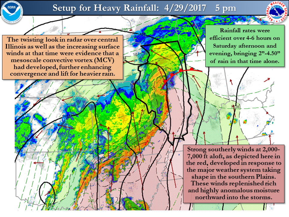
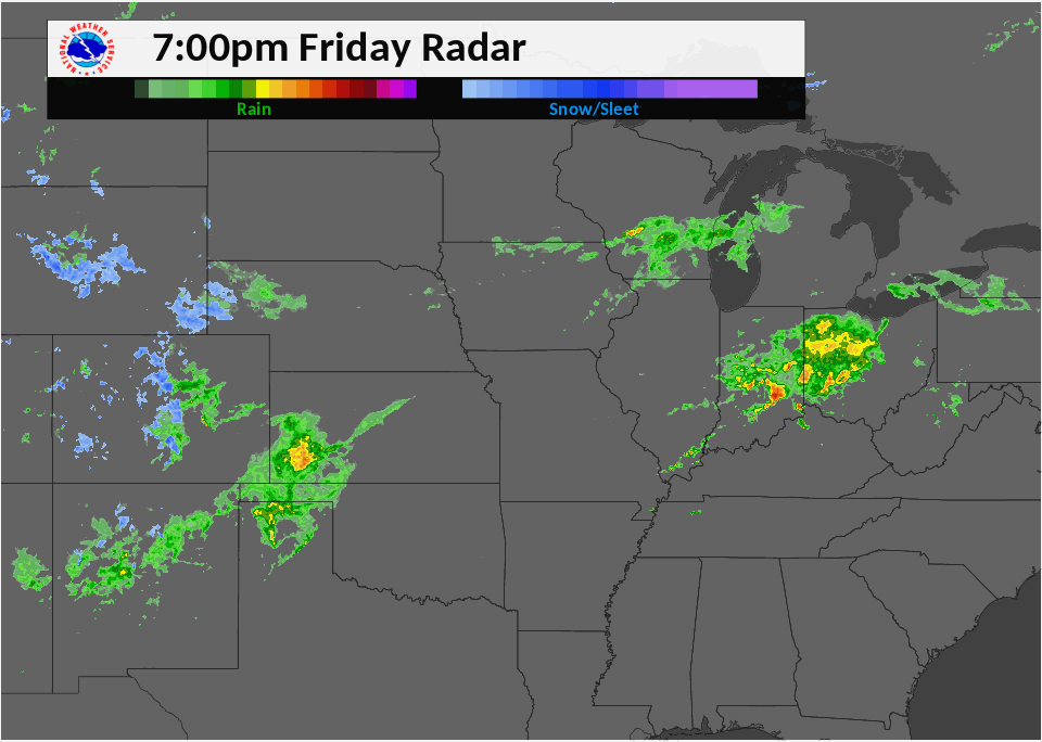
| Heavy rain setup from April 29. | NWS Chicago radar loop from 4pm-10 pm on April 29, which.was during the time of heaviest rainfall. |
Additional Information
Summaries From Other NWS Offices
NWS Chicago Science & Past Events Page
 |
Media use of NWS Web News Stories is encouraged! Please acknowledge the NWS as the source of any news information accessed from this site. |
|