
A slow moving weather disturbance will continue to bring periodic rain showers, a few isolated thunderstorms, and a localized flash flooding across the Southwest. The threat will expand into the Southern Plains Wednesday night. Moderate to heavy snow across the Sierra Nevada and southern Utah Ranges will continue into the overnight period. Read More >
|
Overview Late on the night of July 11 into the morning of July 12, multiple waves of thunderstorms moved across southern Wisconsin and northeast Illinois. With summertime moisture at its maximum, the storms produced copious rainfall rates. Given the training nature over the same location, substantial rainfall amounts resulted. This brought flash flooding by daybreak on July 12 that continued through that entire day and into the next night. In addition, river flooding became a major problem and continues, especially on the Des Plaines and Fox Rivers. For more on the rivers, visit our AHPS page. |
 |
River Flooding
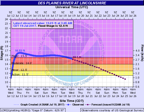
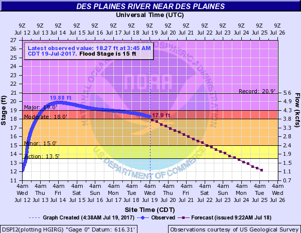
The rivers in northeast Illinois that have experienced the most flooding from the July 2017 rainfall event are the Des Plaines River and the Fox River. Record flooding occurred on the Des Plaines River in northeast Illinois.
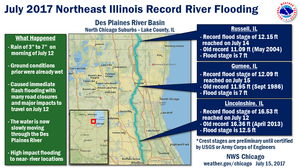
Record River Flood Information
The following are preliminary record crests for rivers that have crested in northern Illinois. All data is preliminary until certified by the U.S. Geological Survey (USGS) or U.S. Army Corps of Engineers.
|
River
|
Location
|
July 2017
Crest |
Date
|
Previous
Record |
Date
|
|
Des Plaines River
|
12.15 ft |
7/14
|
11.09 ft
|
5/23/2004
|
|
|
Des Plaines River
|
12.09 ft
|
7/15
|
11.95 ft
|
9/27/1986 | |
|
Des Plaines River
|
16.53 ft
|
7/12
|
16.36 ft |
4/19/2013
|
The Fox River at Algonquin, IL crested at 12.38 ft on July 18. The record river stage for there is 12.70 ft observed on April 23, 2013.
In southeast Wisconsin, the Fox River at both Burlington and New Munster has also had preliminary record crests from this rainfall event. See NWS Milwaukee for more.
The Des Plaines River at the town of Des Plaines has had a preliminary crest of 19.88 ft on 7/14, below the record flood stage 20.92 ft (4/19/2013).
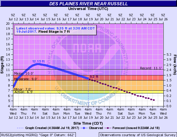
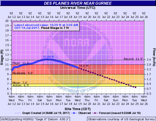
Observed Hydrographs
| Des Plaines River | |||
 |
 |
 |
 |
|
Russell, IL
|
Gurnee, IL |
Lincolnshire, IL | Des Plaines, IL |
| Fox River | |
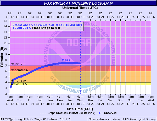 |
 |
| McHenry Lock/Dam, IL | Algonquin (Tailwater), IL |
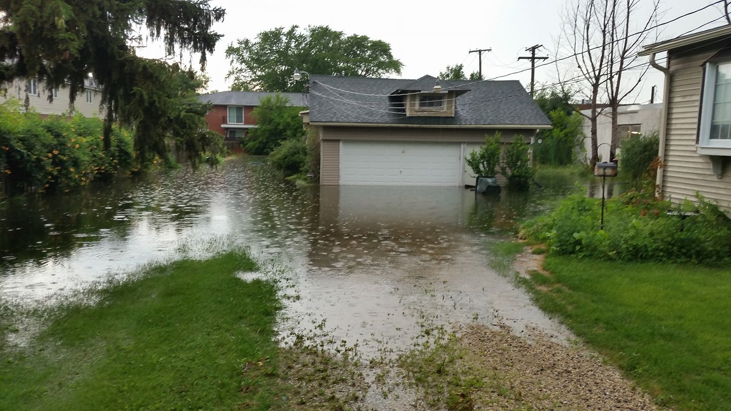
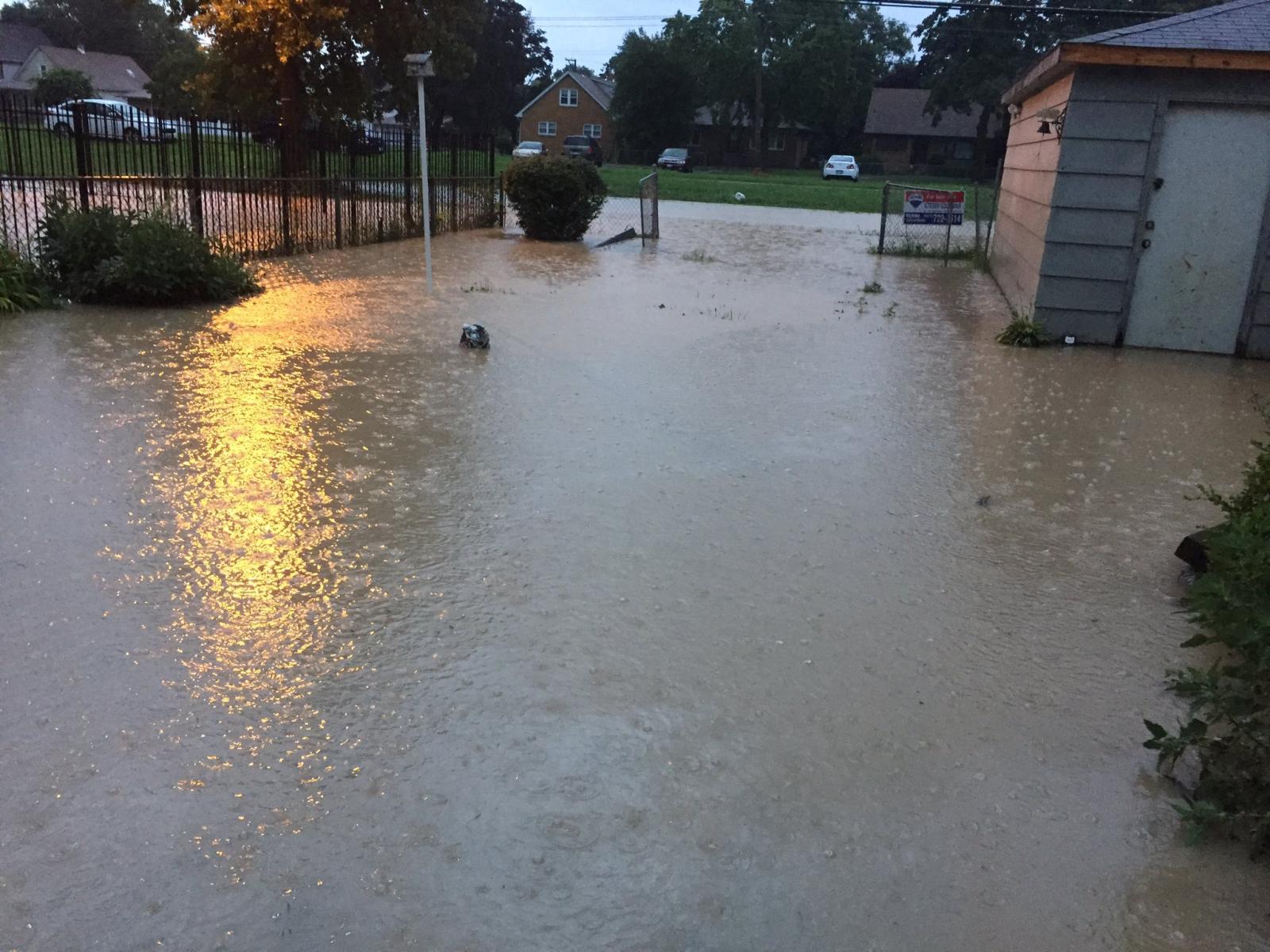
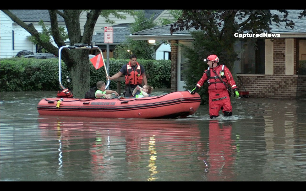
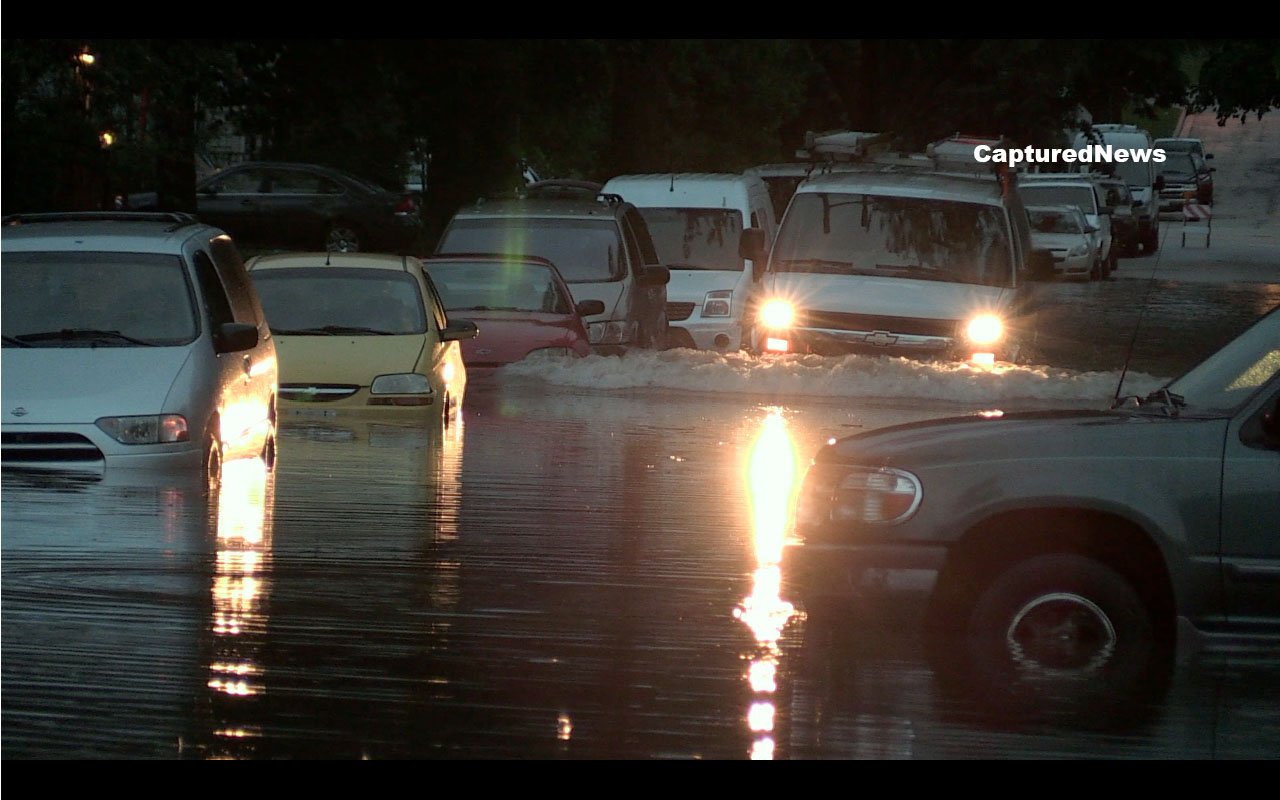
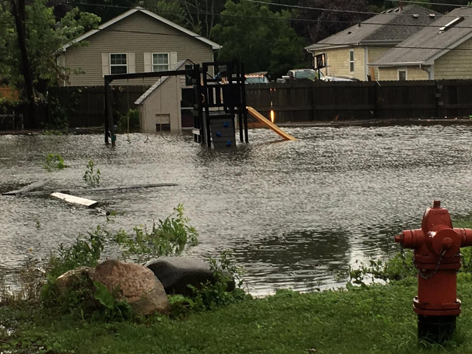
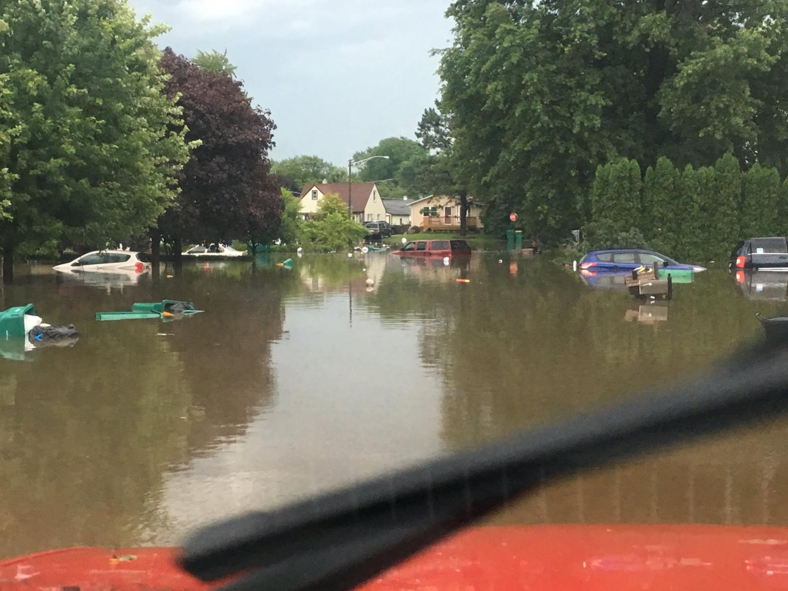
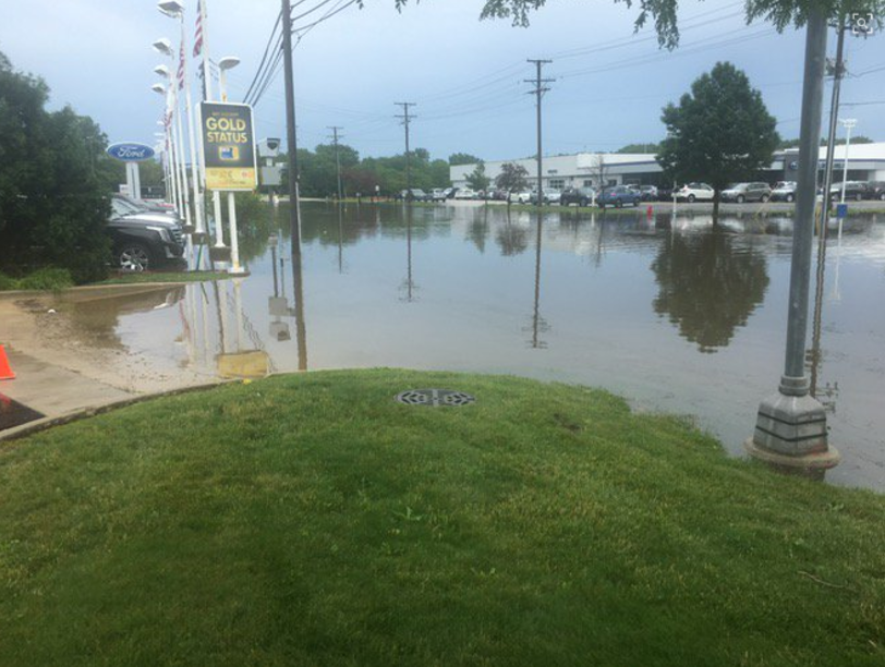
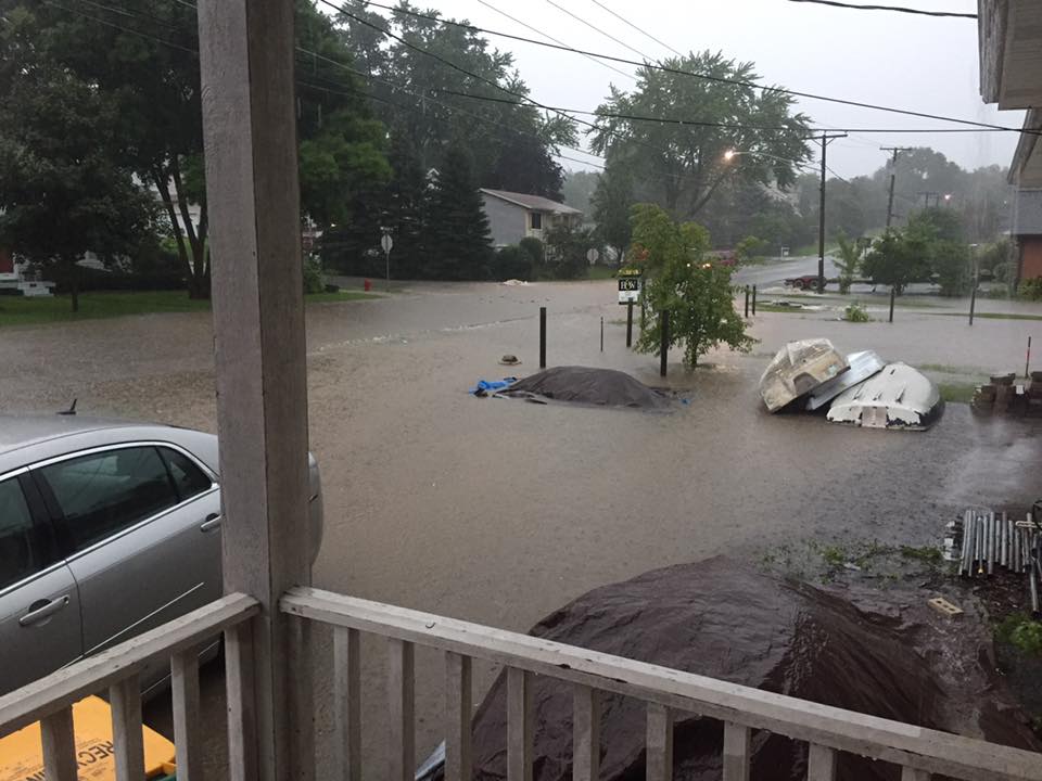
Flash Flooding
Lake County, Illinois
 |
 |
 |
 |
|
Antioch, IL
Courtesy of Christopher McBrady
|
North Chicago, IL Courtesy of Howard J. Miller |
Mundelein, IL
Courtesy of Media partners |
Mundelein, IL Courtesy of Media partners |
 |
 |
 |
 |
| Round Lake Beach, IL Courtesy of Michael Ballinger |
Round Lake Beach, IL
Courtesy of Michael Ballinger
|
Highland Park, IL
Courtesy of RoseanneT ellez
|
Wauconda, IL Courtesy of Edward Sturtevant |
Rainfall
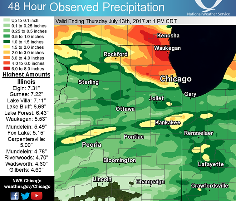 |
|
48-Hour Rainfall Amounts
Based on Radar and NWS Cooperative Observers and CoCoRaHS observers |
PUBLIC INFORMATION STATEMENT
NATIONAL WEATHER SERVICE CHICAGO/ROMEOVILLE IL
1022 AM CDT THU JUL 13 2017


...2-DAY RAINFALL ROUND-UP...

THE FOLLOWING ARE RAINFALL AMOUNTS FOR THE PREVIOUS 2 DAYS
AS MEASURED IN THE MORNING BY NWS COOPERATIVE OBSERVERS
AND COCORAHS OBSERVERS. OBSERVATIONS ARE USUALLY
TAKEN AT 7 AM.

  2-DAY RAIN TOTALS FOR THURSDAY (07/13/17)
     AS OF 10:22 AM CDT

ILLINOIS                                 2-DAY RAINFALL
  LOCATION (COUNTY):                         AMT(IN) REPORTS

  ELGIN 1S (KANE)..............................7.31     (2)
  GURNEE 2W (LAKE).............................7.22     (2)
  LAKE VILLA 2WSW (LAKE).......................7.11     (2)
  LAKE VILLA 1SSW (LAKE).......................7.11     (2)
  LAKE BLUFF 1W (LAKE).........................6.69     (2)
  LAKE FOREST 2NNE (LAKE)......................6.46     (2)
  WAUKEGAN 2E (LAKE)...........................5.53     (2)
  MUNDELEIN 2WNW (LAKE)........................5.49     (2)
  ELGIN 2WNW (KANE)............................5.24     (2)
  FOX LAKE 2SE (LAKE)..........................5.15     (2)
  CARPENTERSVILLE 1E (KANE)....................5.00     (2)
  MUNDELEIN (LAKE).............................4.78     (2)
  RIVERWOODS (LAKE)............................4.70     (2)
  WAUKEGAN 2N (LAKE)...........................4.68     (2)
  WADSWORTH 1SSE (LAKE)........................4.60     (2)
  GILBERTS (KANE)..............................4.60     (2)
  LAKEMOOR 2SE (LAKE)..........................4.55     (2)
  BANNOCKBURN (LAKE)...........................4.52     (2)
  BARRINGTON (LAKE)............................4.47     (2)
  HIGHWOOD 1S (LAKE)...........................4.41     (2)
  LINCOLNSHIRE 1N (LAKE).......................4.40     (2)
  ALGONQUIN 1N (MCHENRY).......................4.25     (2)
  ELGIN 2NE (KANE).............................4.08     (2)
  HOFFMAN ESTATES 5W (COOK)....................4.07     (2)
  ARLINGTON HEIGHTS 1SW (COOK).................3.93     (2)
  PALATINE 1NNE (COOK).........................3.81     (2)
  WHEELING (COOK)..............................3.77     (2)
  BOTANIC GARDENS (COOK).......................3.76     (2)
  CARY (MCHENRY)...............................3.72     (2)
  BUFFALO GROVE 2N (LAKE)......................3.72     (2)
  SLEEPY HOLLOW 1SE (KANE).....................3.64     (2)
  WAUKEGAN (LAKE)..............................3.63     (2)
  LAKE ZURICH 1N (LAKE)........................3.56     (2)
  ZION (LAKE)..................................3.54     (2)
  ELGIN (KANE).................................3.54     (2)
  LAKE IN THE HILLS 1ESE (MCHENRY).............3.45     (2)
  WINTHROP HARBOR 1SSW (LAKE)..................3.42     (2)
  CARY (MCHENRY)...............................3.39     (2)
  LAKE ZURICH (LAKE)...........................3.36     (2)
  ARLINGTON HEIGHTS 3SSW (COOK)................3.27     (2)
  SCHAUMBURG 2E (COOK).........................3.18     (2)
  WINTHROP HARBOR (LAKE).......................3.18     (2)
  HUNTLEY (MCHENRY)............................3.06     (2)
  ELK GROVE VILLAGE 2WSW (COOK)................3.06     (2)
  PALATINE 1E (COOK)...........................3.03     (2)
  MCHENRY (MCHENRY)............................2.88     (2)
  ELGIN 8WSW (KANE)............................2.83     (2)
  BULL VALLEY 2WNW (MCHENRY)...................2.80     (2)
  ELK GROVE VILLAGE 1ESE (COOK)................2.78     (2)
  DWIGHT 4NNW (GRUNDY).........................2.69     (2)
  CRYSTAL LAKE 1WSW (MCHENRY)..................2.57     (2)
  LAKE IN THE HILLS 2.5W (MCHENRY).............2.51     (2)
  WONDER LAKE 1WNW (MCHENRY)...................2.47     (2)
  OHARE (COOK).................................2.33     (2)
  WINNETKA 1ESE (COOK).........................2.33     (2)
  BELVIDERE 2NW (BOONE)........................2.22     (2)
  PARK RIDGE (COOK)............................2.21     (2)
  MANTENO 2NW (KANKAKEE).......................2.20     (2)
  VILLA PARK 1NW (DU PAGE).....................2.10     (2)
  WOODSTOCK 4SW (MCHENRY)......................2.09     (2)
  ELMHURST 1ESE (DU PAGE)......................1.84     (2)
  HARWOOD HEIGHTS (COOK).......................1.79     (2)
  BELVIDERE (BOONE)............................1.77     (2)
  HEBRON (MCHENRY).............................1.68     (2)
  PLAINFIELD 5SW (KENDALL).....................1.68     (2)
  ELMHURST (DU PAGE)...........................1.58     (2)
  WOODSTOCK 5NW (MCHENRY)......................1.54     (2)
  OAK PARK 1SW (COOK)..........................1.54     (2)
  LINCOLNWOOD 2E (COOK)........................1.47     (2)
  ROCKFORD 2ENE (WINNEBAGO)....................1.46     (2)
  BEECHER 3SSE (WILL)..........................1.45     (2)
  CAROL STREAM (DU PAGE).......................1.43     (2)
  CHATSWORTH (LIVINGSTON)......................1.40     (2)
  OAK PARK 2S (COOK)...........................1.39     (2)
  GLEN ELLYN 1NNW (DU PAGE)....................1.37     (2)
  ROCKFORD 1NW (WINNEBAGO).....................1.37     (2)
  LOMBARD 1NNW (DU PAGE).......................1.31     (2)
  ROGERS PARK 2SW (COOK).......................1.28     (2)
  CHICAGO 6ESE (COOK)..........................1.25     (2)
  OAK PARK 1NNE (COOK).........................1.21     (2)
  DWIGHT (LIVINGSTON)..........................1.19     (2)
  ROCKFORD 3NE (WINNEBAGO).....................1.18     (2)
  STREATOR 1WSW (LA SALLE).....................1.17     (2)
  CAPRON (BOONE)...............................1.16     (2)
  HARVARD (MCHENRY)............................1.15     (2)
  GLEN ELLYN 1WSW (DU PAGE)....................1.13     (2)
  STREATOR 4ENE (LA SALLE).....................1.12     (2)
  GENEVA 1SSW (KANE)...........................1.10     (2)
  PLAINFIELD 2SSE (WILL).......................1.09     (2)
  BONFIELD 4WSW (KANKAKEE).....................1.08     (2)
  GENOA (DE KALB)..............................1.07     (2)
  WHEATON 2NNE (DU PAGE).......................1.05     (2)
  LILY LAKE 2E (KANE)..........................1.03     (2)
  ELWOOD 5NE (WILL)............................1.02     (2)


INDIANA                                    2-DAY RAINFALL
  LOCATION (COUNTY):                         AMT(IN) REPORTS

  REMINGTON (JASPER)...........................1.56     (2)
  DE MOTTE 1SSW (JASPER).......................1.40     (2)
  LOWELL (LAKE)................................1.22     (2)
  KENTLAND 2SSE (NEWTON).......................1.03     (2)


$$
Storm Reports
PRELIMINARY LOCAL STORM REPORT...SUMMARY
NATIONAL WEATHER SERVICE CHICAGO/ROMEOVILLE IL
505 AM CDT FRI JUL 14 2017

..TIME...   ...EVENT...      ...CITY LOCATION...     ...LAT.LON...
..DATE...   ....MAG....      ..COUNTY LOCATION..ST.. ...SOURCE....
            ..REMARKS..

1033 PM     HAIL             PINGREE GROVE           42.07N 88.41W
07/11/2017  E1.00 INCH       KANE               IL   TRAINED SPOTTER

            ALSO 3-5 INCH DIAMETER LIMBS DOWN

1039 PM     TSTM WND GST     PINGREE GROVE           42.07N 88.41W
07/11/2017  M78.00 MPH       KANE               IL   MESONET

            MEASURED ON HOME WEATHER STATION

1115 PM     FLASH FLOOD      PINGREE GROVE           42.07N 88.41W
07/11/2017                   KANE               IL   PUBLIC

            PUBLIC REPORT OF MULTIPLE CARS STUCK IN WATER NEAR ROUTE
            47 AND ROUTE 72 NEAR PINGREE GROVE. MANY ROADS WEST OF
            ELGIN NOT PASSIBLE. VIA SOCIAL MEDIA.

1125 PM     HEAVY RAIN       4 S CARPENTERSVILLE     42.06N 88.26W
07/11/2017  M2.01 INCH       KANE               IL   COCORAHS

            FELL IN AN HOUR AND 40 MINUTES ENDING AT 1125 PM.

1140 PM     FLASH FLOOD      ELGIN                   42.04N 88.29W
07/11/2017                   KANE               IL   LAW ENFORCEMENT

            NUMERIOUS ROADS FLOODED AND IMPASSABLE. BASEMENTS ACROSS
            THE AREA ALSO FLOODED.

0200 AM     FLASH FLOOD      LIBERTYVILLE            42.28N 87.97W
07/12/2017                   LAKE               IL   LAW ENFORCEMENT

            REPORTS OF SIGNIFICANT FLASH FLOODING WITH NUMERIOUS
            ROADS IMPASSABLE.

0334 AM     HEAVY RAIN       1 NNW LINDENHURST       42.43N 88.04W
07/12/2017  M4.20 INCH       LAKE               IL   COCORAHS

0400 AM     HEAVY RAIN       2 W GURNEE              42.38N 87.98W
07/12/2017  M5.40 INCH       LAKE               IL   COCORAHS

0455 AM     HEAVY RAIN       3 W ELGIN               42.04N 88.35W
07/12/2017  M4.29 INCH       KANE               IL   COCORAHS

0506 AM     HEAVY RAIN       LIBERTYVILLE            42.28N 87.97W
07/12/2017  M5.17 INCH       LAKE               IL   EMERGENCY MNGR

0515 AM     HEAVY RAIN       1 W LAKE BLUFF          42.28N 87.87W
07/12/2017  M5.38 INCH       LAKE               IL   COCORAHS

0526 AM     HEAVY RAIN       GURNEE                  42.38N 87.94W
07/12/2017  M3.42 INCH       LAKE               IL   COCORAHS

0530 AM     FLASH FLOOD      2 SW NORTH CHICAGO      42.30N 87.89W
07/12/2017                   LAKE               IL   BROADCAST MEDIA

            HIGH FLOOD WATERS AT US-41 AND IL-137

0545 AM     HEAVY RAIN       1 SSW LAKE VILLA        42.40N 88.09W
07/12/2017  M5.31 INCH       LAKE               IL   COCORAHS

0557 AM     FLASH FLOOD      GURNEE                  42.38N 87.94W
07/12/2017                   LAKE               IL   DEPT OF HIGHWAYS

            IL-132 CLOSED BETWEEN OPLAINE RD AND FIRST ST DUE TO
            FLOODING

0600 AM     FLASH FLOOD      MUNDELEIN               42.27N 88.00W
07/12/2017                   LAKE               IL   BROADCAST MEDIA

            WATER AT LEAST 8-10 INCHES DEEP AT LINCOLN AND DIVISION.
            NUMEROUS HOUSES FLOODED AND PEOPLE RESCUED BY RAFTS.

0600 AM     FLASH FLOOD      LIBERTYVILLE            42.28N 87.97W
07/12/2017                   LAKE               IL   BROADCAST MEDIA

            NORTHBOUND 45 BLOCKED AT IL-137 DUE TO HIGH STANDING
            WATER. BUTTERFIELD/VIRGINIA BLOCKED PETERSON RD BLOCKED
            BY INDEPENDENCE RT 21 BLOCKED NORTH OF IL-60

0633 AM     HEAVY RAIN       2 SE LAKEMOOR           42.32N 88.18W
07/12/2017  M2.42 INCH       LAKE               IL   COCORAHS

0638 AM     HEAVY RAIN       3 SE FOX LAKE           42.38N 88.14W
07/12/2017  M4.46 INCH       LAKE               IL   PUBLIC

0648 AM     HEAVY RAIN       MUNDELEIN               42.27N 88.00W
07/12/2017  M6.75 INCH       LAKE               IL   PUBLIC

0657 AM     HEAVY RAIN       ROUND LAKE PARK         42.32N 88.06W
07/12/2017  M7.13 INCH       LAKE               IL   PUBLIC

0825 AM     HEAVY RAIN       2 W GURNEE              42.38N 87.98W
07/12/2017  M1.02 INCH       LAKE               IL   COCORAHS

            RAIN FELL IN THE PAST 1 HOUR.

0840 AM     HAIL             ELK GROVE VILLAGE       42.01N 87.99W
07/12/2017  M0.75 INCH       COOK               IL   TRAINED SPOTTER

0900 AM     HEAVY RAIN       1 N LINCOLNSHIRE        42.21N 87.92W
07/12/2017  M1.01 INCH       LAKE               IL   COCORAHS

            RAIN IN THE PAST HOUR

0913 AM     HAIL             CARY                    42.21N 88.25W
07/12/2017  M0.75 INCH       MCHENRY            IL   TRAINED SPOTTER

0919 AM     HAIL             MUNDELEIN               42.27N 88.00W
07/12/2017  M0.75 INCH       LAKE               IL   TRAINED SPOTTER

0920 AM     TSTM WND DMG     BUFFALO GROVE           42.17N 87.96W
07/12/2017                   LAKE               IL   LAW ENFORCEMENT

            BRANCHES DOWN.

0935 AM     HAIL             GLENVIEW                42.08N 87.82W
07/12/2017  E0.75 INCH       COOK               IL   PUBLIC

0940 AM     MARINE TSTM WIND 6 E GLENCOE             42.13N 87.65W
07/12/2017  M51.00 MPH       LMZ740             IL   BUOY

0943 AM     HEAVY RAIN       HOFFMAN ESTATES         42.06N 88.14W
07/12/2017  M1.70 INCH       COOK               IL   TRAINED SPOTTER

            RAIN FELL IN THE PAST 45 MINUTES. ALSO SMALL HAIL.

0945 AM     TSTM WND DMG     4 SW PINGREE GROVE      42.02N 88.46W
07/12/2017                   KANE               IL   PUBLIC

            TWENTY POWER LINE POLES SNAPPED OUT AT BASE. TIME
            ESTIMATED OFF OF RADAR.

0950 AM     MARINE TSTM WIND 4 NE CHICAGO            41.92N 87.57W
07/12/2017  M47.00 MPH       LMZ741             IL   C-MAN STATION

1022 AM     FLOOD            CHICAGO                 41.88N 87.63W
07/12/2017                   COOK               IL   PUBLIC

            STANDING WATER OF TWO TO SIX INCHES NEAR LAKE SHORE DRIVE
            AND BELMONT.

0300 PM     HEAVY RAIN       5 NNW ADDISON           42.00N 88.05W
07/12/2017  E1.66 INCH       COOK               IL   COCORAHS

            LOW AREA PONDING SOUTHWEST SIDE OF ELK GROVE
            VILLAGE.TOTAL SINCE 530 AM

0700 AM     HEAVY RAIN       2 WSW LAKE VILLA        42.41N 88.12W
07/13/2017  M7.11 INCH       LAKE               IL   COCORAHS

            2 DAY TOTAL

0700 AM     HEAVY RAIN       2 SE LAKEMOOR           42.32N 88.18W
07/13/2017  M4.55 INCH       LAKE               IL   COCORAHS

            2 DAY TOTAL

0700 AM     HEAVY RAIN       1 W LAKE BLUFF          42.28N 87.87W
07/13/2017  M6.69 INCH       LAKE               IL   COCORAHS

            2 DAY TOTAL

0700 AM     HEAVY RAIN       1 S ELGIN               42.03N 88.29W
07/13/2017  M7.31 INCH       KANE               IL   COCORAHS

            2 DAY TOTAL

0700 AM     HEAVY RAIN       2 W GURNEE              42.38N 87.98W
07/13/2017  M7.22 INCH       LAKE               IL   COCORAHS

            2 DAY TOTAL

0700 AM     HEAVY RAIN       1 E CARPENTERSVILLE     42.12N 88.25W
07/13/2017  M5.00 INCH       KANE               IL   COCORAHS

            2 DAY TOTAL
Additional
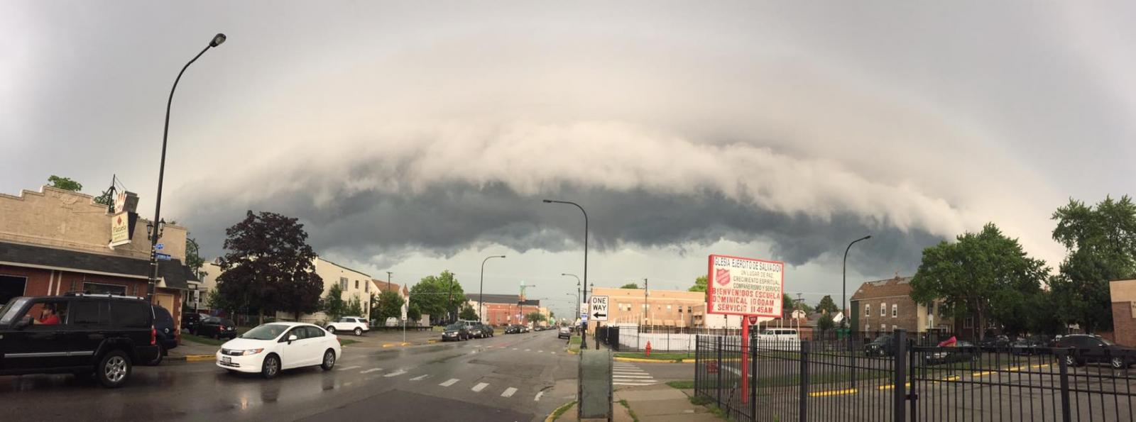
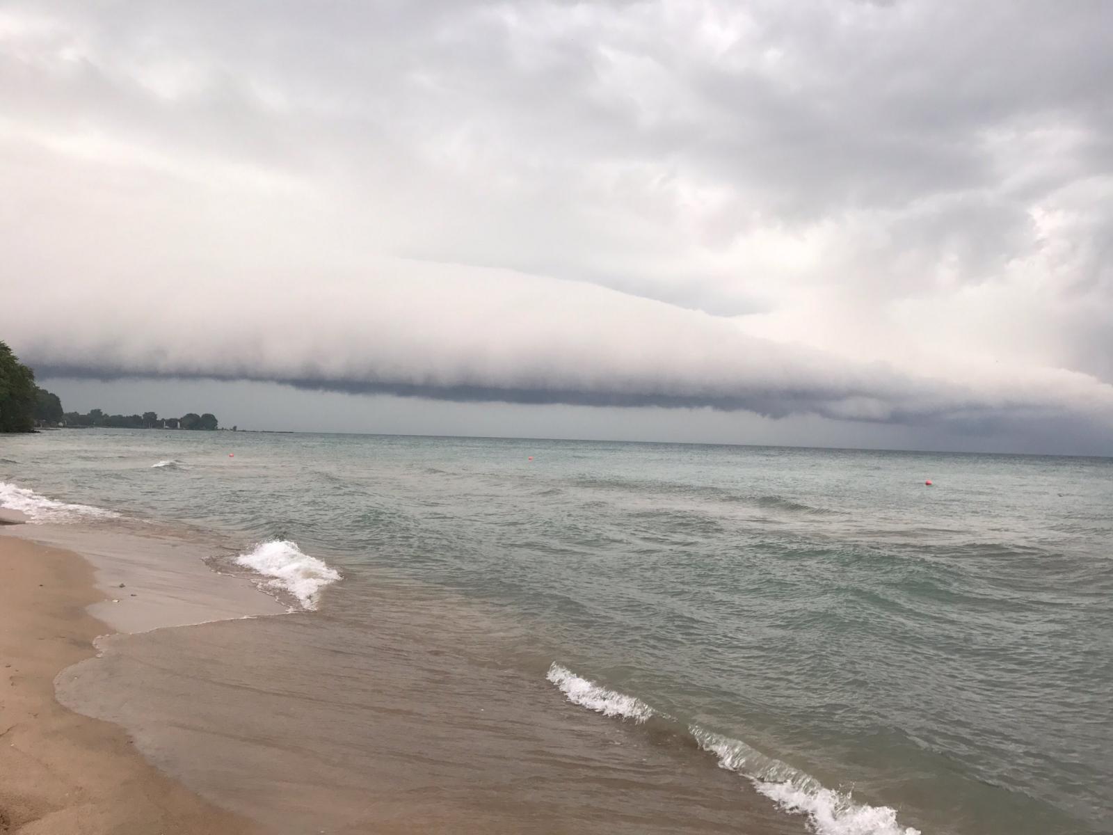
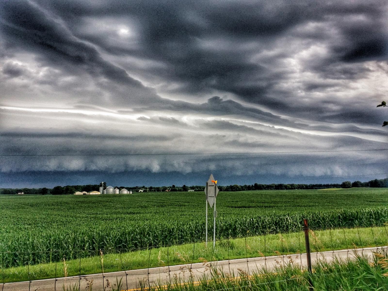
Shelf Cloud Photos From July 12
 |
 |
 |
|
Cicero, IL
Courtesy of Kevin Sheely
|
Near Evanston Beach
Courtesy of Planet Chicago
|
Near Campton Hills
Courtesy of Tim Felinski
|
 |
Media use of NWS Web News Stories is encouraged! Please acknowledge the NWS as the source of any news information accessed from this site. |
|

