| Cold Temperatures Make an Extended Visit to West Texas 30 December 2017 - 2 January 2018 |
|
 |
|
| Wintry scene near Crosbyton on New Year's Eve, December 31, 2017. The picture is courtesy of KAMC. | |
| The year of 2017 went out on a cold and wintry note. After a warm Friday, a cold front moved through the South Plains early Saturday morning, December 30th. Temperatures quickly fell below the freezing mark Saturday, where the stayed for an extended periods of time. The first round of cold air combined with lingering low-level moisture to create widespread freezing fog and freezing drizzle from Saturday into early Sunday. A light glaze of ice coated many objects and did create a few slick spots on area roadways. | |
 |
|
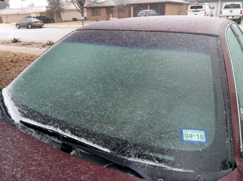
| A light glaze of ice coats a car in South Lubbock New Year's Eve morning. | |
| A second surge of even colder Arctic air then poured into northwest Texas early Sunday morning (31 December 2017). Temperatures dropped into the teens where they largely stayed through New Year's Eve Day. This colder air caused the freezing drizzle to change to light snow. These snow showers persisted through much of the day before tapering off Sunday evening. | |
 |
|
| Lubbock radar animation valid from 10:01 am to 11:51 am on December 31, 2017 | |
| The above radar animation shows the narrow bands of snow that blanketed the South Plains Sunday morning. Minor accumulations of a dusting to a few tenths of an inch of light fluffy snow were observed in many locations over the course of the day Sunday. The snow was generally light enough to keep travel problems to a minimum, though it did whiten the ground. Officially the Lubbock Airport recorded 0.3" of snowfall, though only a trace of liquid equivalent. This was the first measurable snowfall of the season and the first measurable snow since January 6th, 2017, nearly a year earlier. | |
 |
|
| Wintry scene at Whiteface on New Year's Eve, December 31, 2017. The picture is courtesy of KAMC. | |
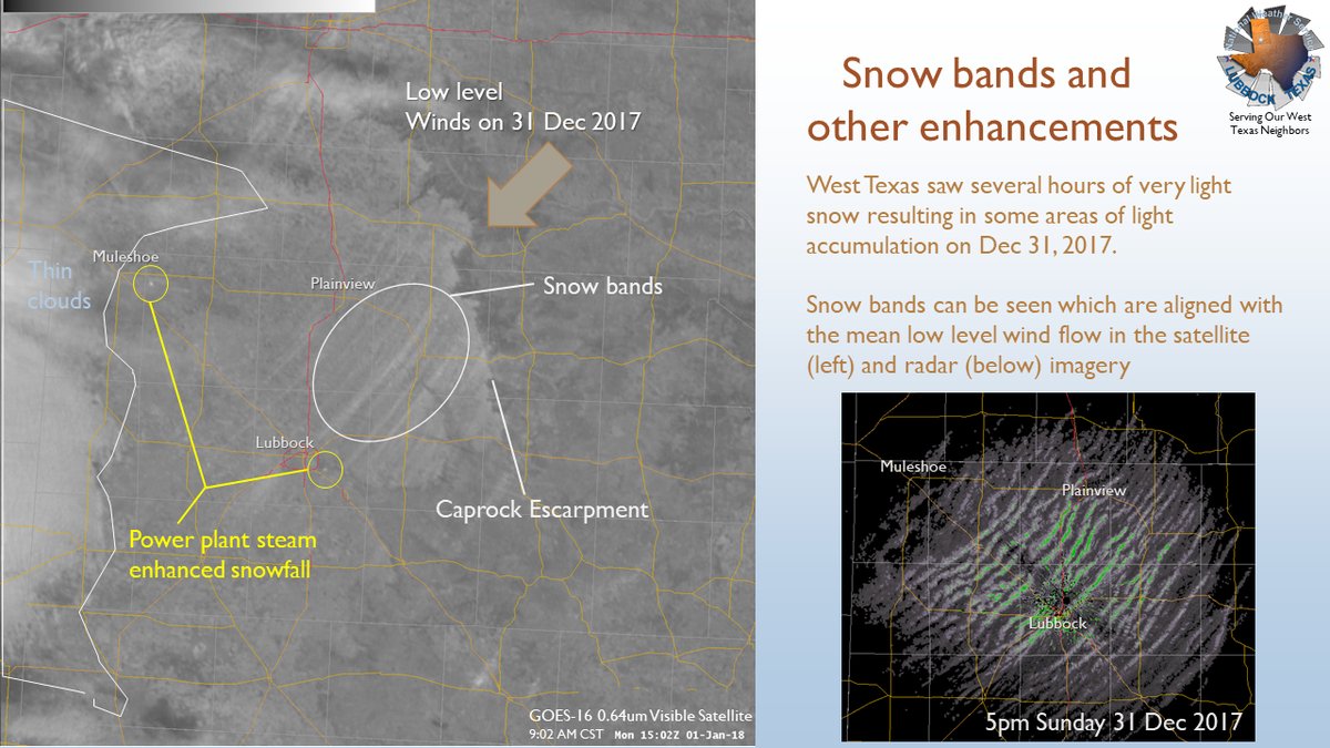
| The below visible satellite imagery taken the next morning (1 January 2018) nicely displays where the heavier swaths of snow accumulated. The picture also shows out a couple of heavier points of snowfall just downstream of power plants, where moisture/steam locally enhanced the snowfall. | |
 |
|
| Visible satellite image captured at 9:02 am on 1 January 2018 along with a snapshot of the Lubbock radar the previous evening at 5 pm. | |
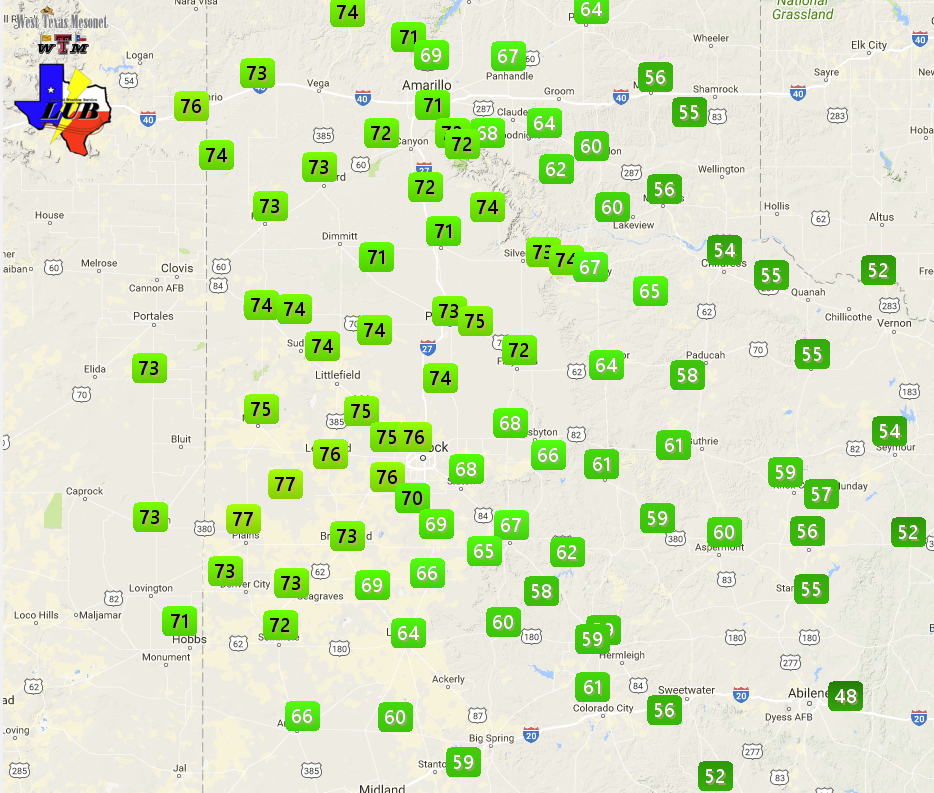
| A sprawling high pressure that supplied the cold temperatures to West Texas, as well as most of the nation east of the Rockies to close out 2017, then took its time to depart the region. This kept temperatures frigid right on into the beginning of 2018. The below images show the drastic change when highs fell from the 60s and 70s on Friday to the 30s and 40s Saturday. In fact Lubbock topped out at 76 degrees on December 29th, coming up just one degree shy of a record (77 degrees set in 1920). The following day the high officially hit 37 degrees, but this occurred just after midnight, and the temperature dropped through freezing at 7:53 am Saturday morning where it stayed the next few days. The temperature finally managed to climb to freezing briefly Tuesday afternoon (2 January 2018) after 79 hours below the 32 degree mark. However, the high on Tuesday didn't exceed freezing and the streak of temperatures at or below 32 degrees continued on into Wednesday. | |
 |
 |
| Observed high temperatures on Friday, December 29th (left) and Saturday, December 30th (right). The observations are courtesy of the West Texas Mesonet. | |
|
Temperatures remained well below freezing December 31st, making New Year's Eve celebrations a chilly one. Lows dropped all the way into the single digits the morning of the 1st, with wind chills even lower, below zero at times. Lubbock officially dropped to 4 degrees to kick off the New Year. Although this was shy of the record of -2 degrees (set in 1919), it did tie for the 3rd coldest temperature since 2000, but only the 96th coldest since records began in 1911. |
|
 |
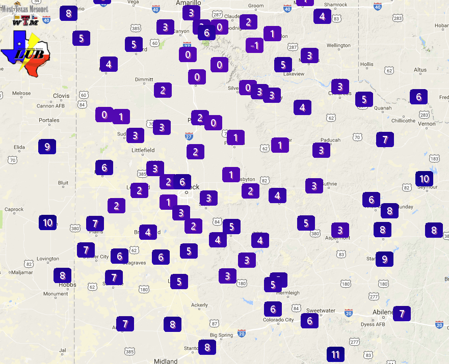 |
| Observed high temperatures on Sunday, December 31st (left) and lows Monday, January 1st (right). The observations are courtesy of the West Texas Mesonet. | |
| Plenty of sunshine and light winds did allow temperatures to recover into the lower and middle 20s at most locations on Monday. Another cold night followed with lows back down in the single digits early Tuesday morning, including Lubbock which bottomed out at 5 degrees. A brief surge of low clouds did bring very light snow to parts of the southern South Plains Tuesday morning, but sun quickly returned thereafter. This allowed temperatures to moderate further, with highs Tuesday afternoon climbing into the upper 20s off the Caprock, with lower and middle 30s common on the Caprock. | |
 |
 |
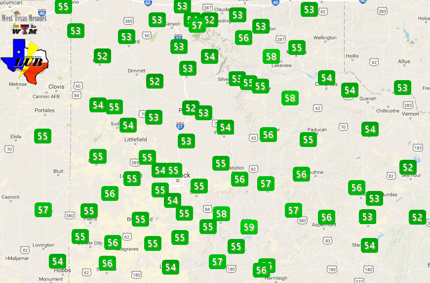
| Observed high temperatures on Monday, January 1, 2018 (left) and lows Tuesday, January 2nd (right). The observations are courtesy of the West Texas Mesonet. To view the high temperatures observed on January 2nd CLICK HERE. The lows the morning of Wednesday, the 3rd, can be VIEWED HERE. Highs on the 3rd can be FOUND HERE. | |
| It wasn't quite as cold Tuesday night, mostly in the teens, before temperatures finally rebounded more significantly on Wednesday. High temperatures topped out close to average, in the middle 50s for most spots. For those of you counting, the temperature at Lubbock officially climbed above the freezing mark at 9:29 am Wednesday, ending a 97 hour and 36 minute stretch of readings at or below 32 degrees. | |

