
A storm system will shift across the southwest U.S. through Thursday with widespread showers and isolated thunderstorms. Isolated flooding is possible. High-elevation snow is also expected in parts of Nevada and the southern Sierra Nevada range. East of this storm, above average temperatures will challenge or break daily record high temperatures this week in the southern Plains and southeast U.S. Read More >
|
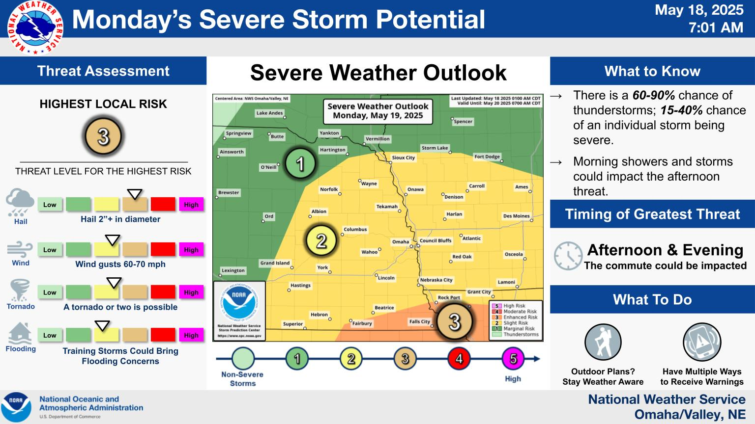
Local WWA Map
|
Local Radar
|
Omaha Weather Story
|
|
National WWA Map
|
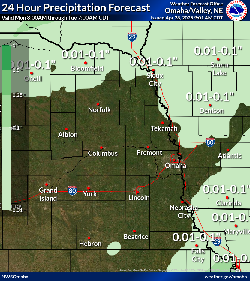
QPF Day 1
|
Local QPF Day 1
|
|
SPC Day 1
|
Local Severe Day 1
|
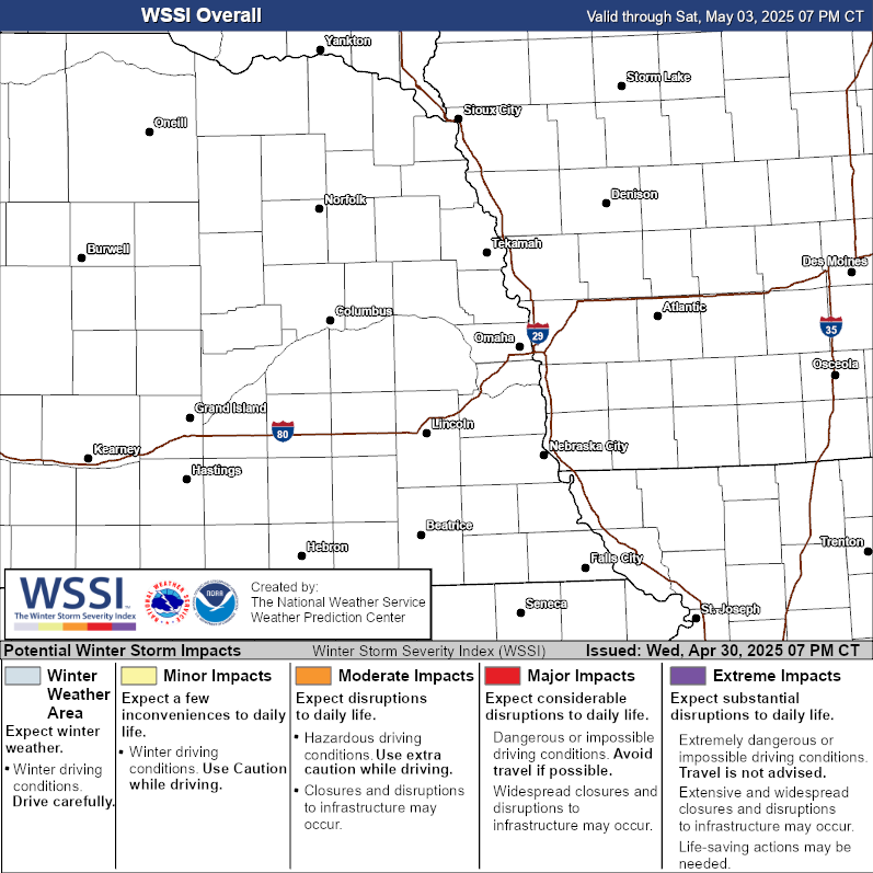
Storm Total Snow Forecast
|
NPW | WSW | WCN | SVR | TOR | SVS | LSR | FFW | FFS | FLW | FLS
CLIOMA | CLILNK | CLIOFK | CLIOAX | RTPOAX | RWRNE | RWRIA
Area Forecast Discussion
386
FXUS63 KOAX 182342
AFDOAX

Area Forecast Discussion
National Weather Service Omaha/Valley NE
542 PM CST Tue Nov 18 2025

.KEY MESSAGES...

- Lingering cloud cover and cool temperatures overnight will
  lead to areas of patchy fog or drizzle (20-30% chance).

- Another storm system will move into the region Friday,
  bringing a 20-50% chance for rain across southeast Nebraska
  and far southern Iowa.

- Mild, dry weather returns over the weekend before a third
  system arrives on Monday.

&&

.DISCUSSION...
Issued at 314 PM CST Tue Nov 18 2025

Today and Tomorrow:

Water vapor imagery this afternoon features yet another spinning low
over the California/Baja coast working to stream moisture into the
Desert Southwest ahead of it, while weak ridging is sandwiched
between it and the departing wave pushing across the southern
Great Lakes region. A recent surface analysis has a cold front
extending along the Nebraska/Kansas border that connects to the
surface low pressure trough near eastern Iowa, with low cloud
cover filling in just to the north of the front. Areas that have
avoided clouds for most of the day have been able to warm into
the lower 50s while the rest of the forecast area has remainder
dreary and chilly in the 40s with northerly winds.

Overnight, the main concern will be lower visibilities, which may
manifest differently across portions of the forecast area. Deeper
moisture will linger along the NE/IA border into northwest and
central Iowa, with low-level lapse rates being steep enough for
some drizzle to develop after 8 PM. The second area of lower
visibility would likely develop late into the overnight hours,
where limited cloud cover will allow for increased radiational
cooling to occur and help surface air temperatures fall to the
crossover temperatures. This area will be focused generally
over south-central Nebraska and north-central Kansas, with
uncertainty as to how far it extends into southeast Nebraska. In
between these two areas, better visibilities are expected
overnight and into tomorrow morning.

For tomorrow, expect to see the bulk of the low-level cloud cover
departing to the east by the afternoon hours, with mid/high clouds
letting us see at least some sun. Winds will swing easterly in the
morning, becoming southerly and gusty by the afternoon hours and we
will see temperatures improve in kind, topping out in the upper 50s
for eastern Nebraska while the border into Iowa reaches the low 50s.

Thursday and Beyond:

In the wee hours of Thursday morning, a weak cold front will once
again begin to swing winds northwesterly -- moving slowly
southeastward while bringing with it continued dry weather as most
of the deeper moisture continues to be relegated to the states south
of the forecast area. High temperatures will counter-intuitively be
as warm if not slightly warmer compared to Wednesday for most of
the area, thanks to clearer skies and lingering southwesterly
winds ahead of the front holding on into the afternoon.

Friday into the weekend continues to trend drier, with the latest
runs of the deterministic and ensemble models ushering the
forcing from the aforementioned CA/Baja low across Kansas with
some of the northern extent of the rainfall clipping our
southern border. Even if we see a northward nudge to the system,
rain will be forecast due to the primary jet stream locking up
the coldest air in Canada. Yet another California coastal low
will have developed by this time, poised to eject northeastward
for another similar patter to what we`ve seen over the last
several days.

&&

.AVIATION /00Z TAFS THROUGH 00Z THURSDAY/...
Issued at 542 PM CST Tue Nov 18 2025

MVFR ceilings favored to stick around into Wednesday, scattering
out toward late morning/early afternoon. Guidance still suggests
some fog/drizzle could develop across central Nebraska and
portions of southwest Iowa overnight, but favors those potential
restrictions staying west and east of the TAF sites. That said,
a few pieces of guidance do suggest some drizzle could sneak
into OMA around 11-14Z, so will need to closely monitor trends.
Otherwise, winds will turn clockwise through the period and
generally remain under 10 kts, starting at northerly to
northeasterly and becoming southeasterly to southerly by early
Wednesday morning.

&&

.OAX WATCHES/WARNINGS/ADVISORIES...
NE...None.
IA...None.

&&

$$

DISCUSSION...Petersen
AVIATION...CA
Hazardous Weather Outlook
675
FLUS43 KOAX 182120
HWOOAX

Hazardous Weather Outlook
National Weather Service Omaha/Valley NE
320 PM CST Tue Nov 18 2025

IAZ043-055-056-069-079-080-090-091-NEZ011-012-015>018-030>034-
042>045-050>053-065>068-078-088>093-192130-
Monona-Harrison-Shelby-Pottawattamie-Mills-Montgomery-Fremont-Page-
Knox-Cedar-Thurston-Antelope-Pierce-Wayne-Boone-Madison-Stanton-
Cuming-Burt-Platte-Colfax-Dodge-Washington-Butler-Saunders-Douglas-
Sarpy-Seward-Lancaster-Cass-Otoe-Saline-Jefferson-Gage-Johnson-
Nemaha-Pawnee-Richardson-
320 PM CST Tue Nov 18 2025

This Hazardous Weather Outlook is for southwest Iowa, west central
Iowa, east central Nebraska, northeast Nebraska and southeast
Nebraska.

.DAY ONE...This afternoon and tonight.

No hazardous weather is expected at this time.

.DAYS TWO THROUGH SEVEN...Wednesday through Monday.

The probability for widespread hazardous weather is low.

.SPOTTER INFORMATION STATEMENT...

Spotter activation is not expected at this time.

$$
Zone Forecast
874
FPUS53 KOAX 182258
ZFPOAX

Zone Forecasts for Eastern Nebraska and Southwest Iowa for Nebraska
National Weather Service Omaha/Valley NE
457 PM CST Tue Nov 18 2025

NEZ052-190600-
Douglas-
Including the city of Omaha
457 PM CST Tue Nov 18 2025

.REST OF TODAY...Cloudy. Near steady temperature in the lower
40s. Temperature falling into the lower 40s late. North winds
around 5 mph.
.TONIGHT...Cloudy. Patchy fog. Lows in the upper 30s. North winds
around 5 mph.
.WEDNESDAY...Mostly cloudy in the morning, then becoming partly
sunny. Patchy fog in the morning. Highs in the mid 50s. South
winds around 5 mph.
.WEDNESDAY NIGHT...Partly cloudy. Lows around 40. South winds
around 5 mph.
.THURSDAY...Mostly sunny. Highs in the upper 50s. North winds
5 to 10 mph.
.THURSDAY NIGHT...Partly cloudy. Lows in the mid 30s.
.FRIDAY...Partly sunny with a slight chance of rain in the
morning, then mostly cloudy with a chance of rain in the
afternoon. Highs in the lower 50s. Chance of rain 30 percent.
.FRIDAY NIGHT...Mostly cloudy with a slight chance of rain in the
evening, then partly cloudy after midnight. Lows in the mid 30s.
Chance of rain 20 percent.
.SATURDAY...Sunny. Highs in the upper 50s.
.SATURDAY NIGHT...Mostly clear. Lows in the mid 30s.
.SUNDAY...Sunny. Highs around 60.
.SUNDAY NIGHT...Mostly clear. Lows in the upper 30s.
.MONDAY...Mostly sunny. Highs in the upper 50s.

$$

NEZ053-190600-
Sarpy-
Including the cities of Bellevue, Papillion, and La Vista
457 PM CST Tue Nov 18 2025

.REST OF TODAY...Cloudy. Near steady temperature in the mid 40s.
Temperature falling into the lower 40s late. North winds around
5 mph.
.TONIGHT...Cloudy. Patchy fog. Lows in the upper 30s. North winds
around 5 mph.
.WEDNESDAY...Mostly cloudy in the morning, then becoming partly
sunny. Patchy fog in the morning. Highs in the mid 50s. South
winds around 5 mph.
.WEDNESDAY NIGHT...Partly cloudy. Lows around 40. South winds
around 5 mph.
.THURSDAY...Mostly sunny. Highs in the upper 50s. North winds
5 to 10 mph.
.THURSDAY NIGHT...Partly cloudy in the evening, then becoming
mostly cloudy. Lows in the upper 30s.
.FRIDAY...Mostly cloudy with a 40 percent chance of rain. Highs
in the lower 50s.
.FRIDAY NIGHT...Mostly cloudy with a slight chance of rain in the
evening, then partly cloudy after midnight. Lows in the mid 30s.
Chance of rain 20 percent.
.SATURDAY...Sunny. Highs in the upper 50s.
.SATURDAY NIGHT...Mostly clear. Lows in the mid 30s.
.SUNDAY...Sunny. Highs around 60.
.SUNDAY NIGHT...Mostly clear. Lows in the upper 30s.
.MONDAY...Mostly sunny. Highs in the upper 50s.

$$

IAZ069-190600-
Pottawattamie-
Including the city of Council Bluffs
457 PM CST Tue Nov 18 2025

.REST OF TODAY...Cloudy. Near steady temperature in the mid 40s.
Temperature falling into the lower 40s late. North winds 5 to
10 mph.
.TONIGHT...Cloudy. Patchy fog. Lows in the upper 30s. Northeast
winds 5 to 10 mph.
.WEDNESDAY...Mostly cloudy in the morning, then becoming partly
sunny. Patchy fog in the morning. Highs in the lower 50s. South
winds around 5 mph.
.WEDNESDAY NIGHT...Partly cloudy. Lows around 40. South winds
around 5 mph.
.THURSDAY...Mostly sunny. Highs in the upper 50s. Northwest winds
5 to 10 mph, becoming north in the afternoon.
.THURSDAY NIGHT...Mostly cloudy in the evening, then becoming
partly cloudy. Lows in the mid 30s.
.FRIDAY...Partly sunny with a slight chance of rain in the
morning, then mostly cloudy with a chance of rain in the
afternoon. Highs in the lower 50s. Chance of rain 30 percent.
.FRIDAY NIGHT...Mostly cloudy with a slight chance of rain in the
evening, then partly cloudy after midnight. Lows in the lower
30s. Chance of rain 20 percent.
.SATURDAY...Sunny. Highs in the upper 50s.
.SATURDAY NIGHT...Mostly clear. Lows in the mid 30s.
.SUNDAY...Sunny. Highs in the upper 50s.
.SUNDAY NIGHT...Mostly clear. Lows in the upper 30s.
.MONDAY...Mostly sunny. Highs in the mid 50s.

$$

NEZ066-190600-
Lancaster-
Including the city of Lincoln
457 PM CST Tue Nov 18 2025

.REST OF TODAY...Cloudy. Near steady temperature in the mid 40s.
North winds 5 to 10 mph.
.TONIGHT...Mostly cloudy. Patchy fog. Lows in the mid 30s.
Northeast winds 5 to 10 mph.
.WEDNESDAY...Patchy fog in the morning. Partly sunny. Highs in
the upper 50s. South winds 5 to 10 mph.
.WEDNESDAY NIGHT...Partly cloudy. Lows in the lower 40s. South
winds around 5 mph, becoming southwest after midnight.
.THURSDAY...Mostly sunny. Highs in the upper 50s. North winds
5 to 10 mph.
.THURSDAY NIGHT...Mostly cloudy. A slight chance of rain after
midnight. Lows in the upper 30s. Chance of rain 20 percent.
.FRIDAY...Mostly cloudy with a 50 percent chance of rain. Highs
around 50.
.FRIDAY NIGHT...Mostly cloudy in the evening, then becoming
partly cloudy. Lows in the mid 30s.
.SATURDAY...Sunny. Not as cool with highs around 60.
.SATURDAY NIGHT...Mostly clear. Lows in the mid 30s.
.SUNDAY...Sunny. Highs in the lower 60s.
.SUNDAY NIGHT...Mostly clear. Lows in the upper 30s.
.MONDAY...Mostly sunny. A slight chance of rain in the afternoon.
Highs in the upper 50s. Chance of rain 20 percent.

$$

NEZ031-190600-
Madison-
Including the city of Norfolk
457 PM CST Tue Nov 18 2025

.REST OF TODAY...Cloudy. Near steady temperature in the lower
40s. North winds around 5 mph.
.TONIGHT...Cloudy. Patchy fog. Lows in the lower 30s. Northeast
winds around 5 mph, becoming southeast after midnight.
.WEDNESDAY...Patchy fog in the morning. Mostly sunny. Not as cool
with highs in the upper 50s. South winds 10 to 15 mph.
.WEDNESDAY NIGHT...Partly cloudy. Lows in the mid 30s. South
winds 5 to 10 mph, becoming west after midnight.
.THURSDAY...Mostly sunny. Highs in the mid 50s. North winds 5 to
10 mph.
.THURSDAY NIGHT...Partly cloudy. Lows around 30.
.FRIDAY...Partly sunny. A slight chance of rain in the afternoon.
Highs in the lower 50s. Chance of rain 20 percent.
.FRIDAY NIGHT...Mostly cloudy in the evening, then becoming
partly cloudy. Lows in the lower 30s.
.SATURDAY...Sunny. Highs around 60.
.SATURDAY NIGHT...Mostly clear. Lows in the lower 30s.
.SUNDAY...Sunny. Highs around 60.
.SUNDAY NIGHT...Mostly clear. Lows in the mid 30s.
.MONDAY...Mostly sunny. Highs in the upper 50s.

$$

NEZ011-190600-
Knox-
Including the cities of Creighton, Bloomfield, Crofton, Wausa,
Verdigre, and Niobrara
457 PM CST Tue Nov 18 2025

.REST OF TODAY...Cloudy. Near steady temperature in the lower
40s. North winds around 5 mph.
.TONIGHT...Cloudy. Patchy fog. Lows in the mid 30s. East winds
around 5 mph, becoming south after midnight.
.WEDNESDAY...Mostly sunny. Not as cool with highs in the upper
50s. South winds 10 to 15 mph.
.WEDNESDAY NIGHT...Mostly clear in the evening, then becoming
partly cloudy. Lows in the upper 30s. Southwest winds 10 to
15 mph, becoming northwest 5 to 10 mph after midnight.
.THURSDAY...Mostly sunny. Highs in the lower 50s. North winds
5 to 10 mph.
.THURSDAY NIGHT...Partly cloudy. Lows in the upper 20s.
.FRIDAY...Mostly sunny. Highs in the lower 50s.
.FRIDAY NIGHT...Partly cloudy. Lows in the mid 30s.
.SATURDAY...Sunny. Highs in the upper 50s.
.SATURDAY NIGHT...Mostly clear. Lows in the lower 30s.
.SUNDAY...Sunny. Highs around 60.
.SUNDAY NIGHT...Mostly clear. Lows in the mid 30s.
.MONDAY...Sunny. Highs in the mid 50s.

$$

NEZ012-190600-
Cedar-
Including the cities of Hartington, Laurel, Randolph,
and Coleridge
457 PM CST Tue Nov 18 2025

.REST OF TODAY...Cloudy. Near steady temperature in the lower
40s. North winds around 5 mph.
.TONIGHT...Cloudy. Patchy fog. Lows in the mid 30s. Northeast
winds around 5 mph, becoming southeast around 5 mph after
midnight.
.WEDNESDAY...Partly sunny in the morning, then clearing. Not as
cool with highs in the mid 50s. South winds 10 to 15 mph.
.WEDNESDAY NIGHT...Mostly clear in the evening, then becoming
partly cloudy. Lows in the upper 30s. South winds around 10 mph
with gusts up to 20 mph, becoming west after midnight.
.THURSDAY...Mostly sunny. Highs in the lower 50s. Northwest winds
5 to 10 mph.
.THURSDAY NIGHT...Partly cloudy. Lows in the upper 20s.
.FRIDAY...Partly sunny. Highs in the lower 50s.
.FRIDAY NIGHT...Partly cloudy. Lows in the mid 30s.
.SATURDAY...Mostly sunny. Highs in the upper 50s.
.SATURDAY NIGHT...Mostly clear. Lows in the lower 30s.
.SUNDAY...Sunny. Highs in the upper 50s.
.SUNDAY NIGHT...Mostly clear. Lows in the mid 30s.
.MONDAY...Mostly sunny. Highs in the mid 50s.

$$

NEZ016-190600-
Antelope-
Including the cities of Neligh and Elgin
457 PM CST Tue Nov 18 2025

.REST OF TODAY...Cloudy. Near steady temperature in the lower
40s. North winds 5 to 10 mph.
.TONIGHT...Cloudy. Patchy fog. Lows in the lower 30s. East winds
around 5 mph, becoming south around 5 mph after midnight.
.WEDNESDAY...Partly sunny in the morning, then clearing. Not as
cool with highs in the upper 50s. South winds 10 to 15 mph with
gusts up to 25 mph.
.WEDNESDAY NIGHT...Mostly clear in the evening, then becoming
partly cloudy. Lows in the mid 30s. Southwest winds 5 to 10 mph
with gusts up to 20 mph, becoming northwest after midnight.
.THURSDAY...Mostly sunny. Highs in the mid 50s. North winds 5 to
10 mph.
.THURSDAY NIGHT...Partly cloudy. Lows around 30.
.FRIDAY...Partly sunny. Highs in the lower 50s.
.FRIDAY NIGHT...Mostly cloudy in the evening, then becoming
partly cloudy. Lows in the mid 30s.
.SATURDAY...Sunny. Highs around 60.
.SATURDAY NIGHT...Mostly clear. Lows in the lower 30s.
.SUNDAY...Sunny. Highs around 60.
.SUNDAY NIGHT...Mostly clear. Lows in the mid 30s.
.MONDAY...Mostly sunny. Highs in the upper 50s.

$$

NEZ017-190600-
Pierce-
Including the cities of Pierce, Plainview, and Osmond
457 PM CST Tue Nov 18 2025

.REST OF TODAY...Cloudy. Near steady temperature in the lower
40s. North winds around 5 mph.
.TONIGHT...Cloudy. Patchy fog. Lows in the mid 30s. Northeast
winds around 5 mph, becoming south after midnight.
.WEDNESDAY...Partly sunny in the morning, then clearing. Not as
cool with highs in the upper 50s. South winds 10 to 15 mph.
.WEDNESDAY NIGHT...Mostly clear in the evening, then becoming
partly cloudy. Lows in the mid 30s. South winds 5 to 10 mph with
gusts up to 20 mph, becoming west after midnight.
.THURSDAY...Mostly sunny. Highs in the mid 50s. North winds 5 to
10 mph.
.THURSDAY NIGHT...Partly cloudy. Lows around 30.
.FRIDAY...Partly sunny. Highs in the lower 50s.
.FRIDAY NIGHT...Partly cloudy. Lows in the lower 30s.
.SATURDAY...Mostly sunny. Highs in the upper 50s.
.SATURDAY NIGHT...Mostly clear. Lows in the lower 30s.
.SUNDAY...Sunny. Highs around 60.
.SUNDAY NIGHT...Mostly clear. Lows in the mid 30s.
.MONDAY...Mostly sunny. Highs in the mid 50s.

$$

NEZ018-190600-
Wayne-
Including the city of Wayne
457 PM CST Tue Nov 18 2025

.REST OF TODAY...Cloudy. Near steady temperature in the lower
40s. North winds 5 to 10 mph.
.TONIGHT...Cloudy. Patchy fog. Lows in the lower 30s. Northeast
winds around 5 mph, becoming southeast after midnight.
.WEDNESDAY...Mostly cloudy in the morning, then clearing. Patchy
fog in the morning. Not as cool with highs in the mid 50s. South
winds 10 to 15 mph.
.WEDNESDAY NIGHT...Partly cloudy. Lows in the mid 30s. South
winds 5 to 10 mph, becoming west after midnight.
.THURSDAY...Mostly sunny. Highs in the mid 50s. North winds 5 to
10 mph.
.THURSDAY NIGHT...Partly cloudy. Lows in the upper 20s.
.FRIDAY...Partly sunny. Highs in the lower 50s.
.FRIDAY NIGHT...Mostly cloudy in the evening, then becoming
partly cloudy. Lows in the lower 30s.
.SATURDAY...Sunny. Highs in the upper 50s.
.SATURDAY NIGHT...Mostly clear. Lows in the lower 30s.
.SUNDAY...Sunny. Highs in the upper 50s.
.SUNDAY NIGHT...Mostly clear. Lows in the mid 30s.
.MONDAY...Mostly sunny. Highs in the mid 50s.

$$

NEZ015-190600-
Thurston-
Including the cities of Pender, Macy, Walthill, and Winnebago
457 PM CST Tue Nov 18 2025

.REST OF TODAY...Cloudy, cooler. Near steady temperature in the
lower 40s. North winds 5 to 10 mph.
.TONIGHT...Cloudy. Patchy fog. Lows in the mid 30s. Northeast
winds around 5 mph, becoming east after midnight.
.WEDNESDAY...Mostly cloudy in the morning, then becoming mostly
sunny. Patchy fog in the morning. Highs in the lower 50s. South
winds 5 to 10 mph.
.WEDNESDAY NIGHT...Partly cloudy. Lows in the mid 30s. South
winds 5 to 10 mph, becoming west after midnight.
.THURSDAY...Mostly sunny. Highs in the mid 50s. North winds 5 to
10 mph.
.THURSDAY NIGHT...Partly cloudy. Lows in the upper 20s.
.FRIDAY...Partly sunny. A slight chance of rain in the afternoon.
Highs around 50. Chance of rain 20 percent.
.FRIDAY NIGHT...Mostly cloudy in the evening, then becoming
partly cloudy. Lows around 30.
.SATURDAY...Sunny. Highs in the upper 50s.
.SATURDAY NIGHT...Mostly clear. Lows in the lower 30s.
.SUNDAY...Sunny. Highs in the upper 50s.
.SUNDAY NIGHT...Mostly clear. Lows in the mid 30s.
.MONDAY...Mostly sunny. Highs in the mid 50s.

$$

NEZ032-190600-
Stanton-
Including the city of Stanton
457 PM CST Tue Nov 18 2025

.REST OF TODAY...Cloudy. Near steady temperature in the lower
40s. North winds around 5 mph.
.TONIGHT...Cloudy. Patchy fog. Lows in the lower 30s. Northeast
winds around 5 mph, becoming southeast after midnight.
.WEDNESDAY...Mostly cloudy in the morning, then becoming mostly
sunny. Patchy fog in the morning. Not as cool with highs in the
mid 50s. South winds 5 to 10 mph.
.WEDNESDAY NIGHT...Partly cloudy. Lows in the mid 30s. South
winds 5 to 10 mph, becoming west after midnight.
.THURSDAY...Mostly sunny. Highs in the mid 50s. North winds 5 to
10 mph.
.THURSDAY NIGHT...Partly cloudy. Lows around 30.
.FRIDAY...Partly sunny. A slight chance of rain in the afternoon.
Highs around 50. Chance of rain 20 percent.
.FRIDAY NIGHT...Mostly cloudy in the evening, then becoming
partly cloudy. Lows in the lower 30s.
.SATURDAY...Sunny. Highs in the upper 50s.
.SATURDAY NIGHT...Mostly clear. Lows in the lower 30s.
.SUNDAY...Sunny. Highs in the upper 50s.
.SUNDAY NIGHT...Mostly clear. Lows in the mid 30s.
.MONDAY...Mostly sunny. Highs in the mid 50s.

$$

NEZ033-190600-
Cuming-
Including the cities of West Point and Wisner
457 PM CST Tue Nov 18 2025

.REST OF TODAY...Cloudy. Near steady temperature in the lower
40s. North winds around 5 mph.
.TONIGHT...Cloudy. Patchy fog. Lows in the mid 30s. North winds
around 5 mph, becoming southeast after midnight.
.WEDNESDAY...Mostly cloudy in the morning, then becoming mostly
sunny. Patchy fog in the morning. Not as cool with highs in the
mid 50s. South winds 5 to 10 mph.
.WEDNESDAY NIGHT...Partly cloudy. Lows in the upper 30s. South
winds 5 to 10 mph, becoming west after midnight.
.THURSDAY...Mostly sunny. Highs in the mid 50s. North winds 5 to
10 mph.
.THURSDAY NIGHT...Partly cloudy. Lows around 30.
.FRIDAY...Partly sunny. A slight chance of rain in the afternoon.
Highs around 50. Chance of rain 20 percent.
.FRIDAY NIGHT...Mostly cloudy in the evening, then becoming
partly cloudy. Lows in the lower 30s.
.SATURDAY...Sunny. Highs in the upper 50s.
.SATURDAY NIGHT...Mostly clear. Lows in the lower 30s.
.SUNDAY...Sunny. Highs in the upper 50s.
.SUNDAY NIGHT...Mostly clear. Lows in the mid 30s.
.MONDAY...Mostly sunny. Highs in the mid 50s.

$$

NEZ034-190600-
Burt-
Including the cities of Tekamah, Oakland, Lyons, and Decatur
457 PM CST Tue Nov 18 2025

.REST OF TODAY...Cloudy, cooler. Near steady temperature in the
lower 40s. Temperature falling into the lower 40s late. North
winds 5 to 10 mph.
.TONIGHT...Cloudy. Patchy fog. Lows in the mid 30s. Northeast
winds around 5 mph.
.WEDNESDAY...Mostly cloudy in the morning, then becoming mostly
sunny. Patchy fog in the morning. Highs in the mid 50s. South
winds 5 to 10 mph.
.WEDNESDAY NIGHT...Partly cloudy in the evening, then clearing.
Lows in the upper 30s. South winds around 5 mph.
.THURSDAY...Mostly sunny. Highs in the mid 50s. North winds 5 to
10 mph.
.THURSDAY NIGHT...Partly cloudy. Lows in the lower 30s.
.FRIDAY...Partly sunny. A slight chance of rain in the afternoon.
Highs around 50. Chance of rain 20 percent.
.FRIDAY NIGHT...Mostly cloudy in the evening, then becoming
partly cloudy. Lows in the lower 30s.
.SATURDAY...Sunny. Highs in the upper 50s.
.SATURDAY NIGHT...Mostly clear. Lows in the lower 30s.
.SUNDAY...Sunny. Highs in the upper 50s.
.SUNDAY NIGHT...Mostly clear. Lows in the mid 30s.
.MONDAY...Mostly sunny. Highs in the mid 50s.

$$

NEZ030-190600-
Boone-
Including the cities of Albion and St. Edward
457 PM CST Tue Nov 18 2025

.REST OF TODAY...Cloudy. Near steady temperature in the mid 40s.
North winds 5 to 10 mph.
.TONIGHT...Cloudy. Patchy fog. Lows in the lower 30s. Northeast
winds around 5 mph, becoming south after midnight.
.WEDNESDAY...Patchy fog in the morning. Mostly sunny. Not as cool
with highs in the upper 50s. South winds 10 to 15 mph.
.WEDNESDAY NIGHT...Partly cloudy. Lows in the mid 30s. Southwest
winds 5 to 10 mph, becoming northwest after midnight.
.THURSDAY...Mostly sunny. Highs in the mid 50s. North winds 5 to
10 mph.
.THURSDAY NIGHT...Partly cloudy. Lows around 30.
.FRIDAY...Mostly cloudy in the morning, then becoming partly
sunny. A 20 percent chance of rain. Highs around 50.
.FRIDAY NIGHT...Mostly cloudy in the evening, then becoming
partly cloudy. Lows in the lower 30s.
.SATURDAY...Sunny. Not as cool with highs around 60.
.SATURDAY NIGHT...Mostly clear. Lows in the lower 30s.
.SUNDAY...Sunny. Highs in the lower 60s.
.SUNDAY NIGHT...Mostly clear. Lows in the mid 30s.
.MONDAY...Mostly sunny. Highs in the upper 50s.

$$

NEZ042-190600-
Platte-
Including the city of Columbus
457 PM CST Tue Nov 18 2025

.REST OF TODAY...Cloudy. Near steady temperature in the mid 40s.
North winds 5 to 10 mph.
.TONIGHT...Cloudy. Patchy fog. Lows in the lower 30s. Northeast
winds around 5 mph, becoming southeast after midnight.
.WEDNESDAY...Mostly cloudy in the morning, then becoming mostly
sunny. Patchy fog in the morning. Not as cool with highs in the
upper 50s. South winds 5 to 10 mph.
.WEDNESDAY NIGHT...Partly cloudy. Lows in the upper 30s. South
winds around 5 mph, becoming west after midnight.
.THURSDAY...Mostly sunny. Highs in the mid 50s. North winds 5 to
10 mph.
.THURSDAY NIGHT...Partly cloudy in the evening, then becoming
mostly cloudy. Lows in the lower 30s.
.FRIDAY...Partly sunny with a 20 percent chance of rain. Highs
around 50.
.FRIDAY NIGHT...Mostly cloudy in the evening, then becoming
partly cloudy. Lows in the lower 30s.
.SATURDAY...Sunny. Not as cool with highs around 60.
.SATURDAY NIGHT...Mostly clear. Lows in the lower 30s.
.SUNDAY...Sunny. Highs in the lower 60s.
.SUNDAY NIGHT...Mostly clear. Lows in the mid 30s.
.MONDAY...Mostly sunny. Highs in the upper 50s.

$$

NEZ043-190600-
Colfax-
Including the city of Schuyler
457 PM CST Tue Nov 18 2025

.REST OF TODAY...Cloudy. Near steady temperature in the lower
40s. Temperature falling into the lower 40s late. Northeast winds
around 5 mph.
.TONIGHT...Cloudy. Patchy fog. Lows in the lower 30s. Northeast
winds around 5 mph, becoming southeast after midnight.
.WEDNESDAY...Mostly cloudy in the morning, then becoming mostly
sunny. Patchy fog in the morning. Highs in the mid 50s. South
winds 5 to 10 mph.
.WEDNESDAY NIGHT...Partly cloudy in the evening, then clearing.
Lows in the upper 30s. South winds around 5 mph, becoming west
after midnight.
.THURSDAY...Mostly sunny. Highs in the mid 50s. North winds 5 to
10 mph.
.THURSDAY NIGHT...Partly cloudy. Lows in the lower 30s.
.FRIDAY...Partly sunny with a 20 percent chance of rain. Highs in
the upper 40s.
.FRIDAY NIGHT...Mostly cloudy in the evening, then becoming
partly cloudy. Lows in the lower 30s.
.SATURDAY...Sunny. Not as cool with highs in the upper 50s.
.SATURDAY NIGHT...Mostly clear. Lows in the lower 30s.
.SUNDAY...Sunny. Highs in the upper 50s.
.SUNDAY NIGHT...Mostly clear. Lows in the mid 30s.
.MONDAY...Mostly sunny. Highs in the mid 50s.

$$

NEZ044-190600-
Dodge-
Including the city of Fremont
457 PM CST Tue Nov 18 2025

.REST OF TODAY...Cloudy. Near steady temperature in the lower
40s. Temperature falling into the lower 40s late. North winds
5 to 10 mph.
.TONIGHT...Cloudy. Patchy fog. Lows in the mid 30s. North winds
around 5 mph, becoming east after midnight.
.WEDNESDAY...Mostly cloudy in the morning, then becoming mostly
sunny. Patchy fog in the morning. Highs in the mid 50s. South
winds 5 to 10 mph.
.WEDNESDAY NIGHT...Partly cloudy in the evening, then clearing.
Lows in the upper 30s. South winds around 5 mph, becoming west
after midnight.
.THURSDAY...Mostly sunny. Highs in the upper 50s. North winds
5 to 10 mph.
.THURSDAY NIGHT...Partly cloudy. Lows in the lower 30s.
.FRIDAY...Partly sunny with a 20 percent chance of rain. Highs in
the lower 50s.
.FRIDAY NIGHT...Mostly cloudy in the evening, then becoming
partly cloudy. Lows in the lower 30s.
.SATURDAY...Sunny. Highs in the upper 50s.
.SATURDAY NIGHT...Mostly clear. Lows in the lower 30s.
.SUNDAY...Sunny. Highs around 60.
.SUNDAY NIGHT...Mostly clear. Lows in the mid 30s.
.MONDAY...Mostly sunny. Highs in the upper 50s.

$$

NEZ045-190600-
Washington-
Including the city of Blair
457 PM CST Tue Nov 18 2025

.REST OF TODAY...Cloudy. Near steady temperature in the lower
40s. North winds 5 to 10 mph.
.TONIGHT...Cloudy. Patchy fog. Lows in the upper 30s. North winds
around 5 mph.
.WEDNESDAY...Mostly cloudy in the morning, then becoming partly
sunny. Patchy fog in the morning. Highs in the mid 50s. South
winds 5 to 10 mph.
.WEDNESDAY NIGHT...Partly cloudy in the evening, then clearing.
Lows in the upper 30s. South winds around 5 mph.
.THURSDAY...Mostly sunny. Highs in the upper 50s. North winds
5 to 10 mph.
.THURSDAY NIGHT...Partly cloudy. Lows in the mid 30s.
.FRIDAY...Partly sunny with a slight chance of rain in the
morning, then mostly cloudy with a chance of rain in the
afternoon. Highs in the lower 50s. Chance of rain 30 percent.
.FRIDAY NIGHT...Mostly cloudy with a slight chance of rain in the
evening, then partly cloudy after midnight. Lows in the lower
30s. Chance of rain 20 percent.
.SATURDAY...Sunny. Highs in the upper 50s.
.SATURDAY NIGHT...Mostly clear. Lows in the mid 30s.
.SUNDAY...Sunny. Highs in the upper 50s.
.SUNDAY NIGHT...Mostly clear. Lows in the upper 30s.
.MONDAY...Mostly sunny. Highs in the upper 50s.

$$

NEZ050-190600-
Butler-
Including the city of David City
457 PM CST Tue Nov 18 2025

.REST OF TODAY...Cloudy. Near steady temperature in the lower
40s. Temperature falling into the lower 40s late. North winds
5 to 10 mph.
.TONIGHT...Cloudy. Patchy fog. Lows in the mid 30s. Northeast
winds 5 to 10 mph, becoming east after midnight.
.WEDNESDAY...Patchy fog in the morning. Partly sunny. Highs in
the upper 50s. South winds 5 to 10 mph.
.WEDNESDAY NIGHT...Partly cloudy in the evening, then clearing.
Lows in the upper 30s. South winds around 5 mph, becoming west
after midnight.
.THURSDAY...Mostly sunny. Highs in the upper 50s. North winds
5 to 10 mph.
.THURSDAY NIGHT...Partly cloudy in the evening, then becoming
mostly cloudy. Lows in the mid 30s.
.FRIDAY...Mostly cloudy with a 40 percent chance of rain. Highs
around 50.
.FRIDAY NIGHT...Mostly cloudy in the evening, then becoming
partly cloudy. Lows in the lower 30s.
.SATURDAY...Sunny. Not as cool with highs in the lower 60s.
.SATURDAY NIGHT...Mostly clear. Lows in the mid 30s.
.SUNDAY...Sunny. Highs in the lower 60s.
.SUNDAY NIGHT...Mostly clear. Lows in the upper 30s.
.MONDAY...Mostly sunny. Highs in the upper 50s.

$$

NEZ051-190600-
Saunders-
Including the cities of Wahoo, Ashland, and Yutan
457 PM CST Tue Nov 18 2025

.REST OF TODAY...Cloudy. Near steady temperature in the lower
40s. Temperature falling into the lower 40s late. North winds
5 to 10 mph.
.TONIGHT...Cloudy. Patchy fog. Lows in the mid 30s. Northeast
winds around 5 mph.
.WEDNESDAY...Patchy fog in the morning. Partly sunny. Highs in
the mid 50s. South winds 5 to 10 mph.
.WEDNESDAY NIGHT...Partly cloudy in the evening, then clearing.
Lows in the upper 30s. South winds around 5 mph, becoming
southwest after midnight.
.THURSDAY...Mostly sunny. Highs in the upper 50s. North winds
5 to 10 mph.
.THURSDAY NIGHT...Partly cloudy in the evening, then becoming
mostly cloudy. Lows in the mid 30s.
.FRIDAY...Mostly cloudy. A slight chance of rain in the morning,
then a chance of rain in the afternoon. Highs around 50. Chance
of rain 40 percent.
.FRIDAY NIGHT...Mostly cloudy in the evening, then becoming
partly cloudy. Lows in the lower 30s.
.SATURDAY...Sunny. Not as cool with highs around 60.
.SATURDAY NIGHT...Mostly clear. Lows in the mid 30s.
.SUNDAY...Sunny. Highs around 60.
.SUNDAY NIGHT...Mostly clear. Lows in the upper 30s.
.MONDAY...Mostly sunny. Highs in the upper 50s.

$$

NEZ065-190600-
Seward-
Including the cities of Seward and Milford
457 PM CST Tue Nov 18 2025

.REST OF TODAY...Cloudy. Near steady temperature in the mid 40s.
Temperature falling into the lower 40s late. North winds 5 to
10 mph.
.TONIGHT...Mostly cloudy. Patchy fog. Lows in the mid 30s.
Northeast winds 5 to 10 mph, becoming east after midnight.
.WEDNESDAY...Patchy fog in the morning. Partly sunny. Highs in
the upper 50s. South winds 5 to 10 mph.
.WEDNESDAY NIGHT...Partly cloudy in the evening, then clearing.
Lows around 40. South winds 5 to 10 mph, becoming west after
midnight.
.THURSDAY...Mostly sunny. Highs in the upper 50s. North winds
5 to 10 mph.
.THURSDAY NIGHT...Mostly cloudy. Lows in the mid 30s.
.FRIDAY...Mostly cloudy with a 50 percent chance of rain. Highs
around 50.
.FRIDAY NIGHT...Mostly cloudy in the evening, then becoming
partly cloudy. Lows in the lower 30s.
.SATURDAY...Sunny. Not as cool with highs in the lower 60s.
.SATURDAY NIGHT...Mostly clear. Lows in the mid 30s.
.SUNDAY...Sunny. Highs in the lower 60s.
.SUNDAY NIGHT...Mostly clear. Lows in the upper 30s.
.MONDAY...Mostly sunny. A slight chance of rain in the afternoon.
Highs in the upper 50s. Chance of rain 20 percent.

$$

NEZ078-190600-
Saline-
Including the cities of Crete and Wilber
457 PM CST Tue Nov 18 2025

.REST OF TODAY...Cloudy. Near steady temperature in the mid 40s.
Temperature falling into the mid 40s late. North winds 5 to
10 mph.
.TONIGHT...Mostly cloudy. Patchy fog. Lows in the mid 30s.
Northeast winds 5 to 10 mph, becoming east after midnight.
.WEDNESDAY...Patchy fog in the morning. Partly sunny. Highs in
the upper 50s. South winds 5 to 10 mph.
.WEDNESDAY NIGHT...Partly cloudy. Lows in the lower 40s. South
winds around 5 mph, becoming west after midnight.
.THURSDAY...Mostly sunny. Highs in the upper 50s. North winds
5 to 10 mph.
.THURSDAY NIGHT...Mostly cloudy. A slight chance of rain after
midnight. Lows in the upper 30s. Chance of rain 20 percent.
.FRIDAY...Cloudy. A chance of rain in the morning, then rain
likely in the afternoon. Cooler with highs in the upper 40s.
Chance of rain 60 percent.
.FRIDAY NIGHT...Mostly cloudy in the evening, then becoming
partly cloudy. Lows in the lower 30s.
.SATURDAY...Sunny. Not as cool with highs around 60.
.SATURDAY NIGHT...Mostly clear. Lows in the mid 30s.
.SUNDAY...Sunny. Highs in the lower 60s.
.SUNDAY NIGHT...Mostly clear. Lows in the upper 30s.
.MONDAY...Mostly sunny with a 20 percent chance of rain. Highs in
the upper 50s.

$$

NEZ088-190600-
Jefferson-
Including the city of Fairbury
457 PM CST Tue Nov 18 2025

.REST OF TODAY...Mostly cloudy. Near steady temperature in the
upper 40s. Temperature falling into the upper 40s late. North
winds 5 to 10 mph.
.TONIGHT...Mostly cloudy. Patchy fog. Lows in the mid 30s.
Northeast winds 5 to 10 mph, becoming east after midnight.
.WEDNESDAY...Patchy fog in the morning. Partly sunny. Highs in
the upper 50s. South winds 5 to 10 mph.
.WEDNESDAY NIGHT...Partly cloudy. Lows in the lower 40s. South
winds around 5 mph, becoming southwest after midnight.
.THURSDAY...Partly sunny. Highs around 60. North winds 5 to
10 mph.
.THURSDAY NIGHT...Mostly cloudy. A chance of rain after midnight.
Lows in the upper 30s. Chance of rain 40 percent.
.FRIDAY...Rain likely. Cooler with highs in the upper 40s. Chance
of rain 60 percent.
.FRIDAY NIGHT...Mostly cloudy in the evening, then becoming
partly cloudy. Lows in the lower 30s.
.SATURDAY...Sunny. Highs in the upper 50s.
.SATURDAY NIGHT...Mostly clear. Lows in the mid 30s.
.SUNDAY...Sunny. Highs around 60.
.SUNDAY NIGHT...Mostly clear in the evening, then becoming partly
cloudy. Lows in the upper 30s.
.MONDAY...Mostly sunny with a 20 percent chance of rain. Highs in
the upper 50s.

$$

NEZ089-190600-
Gage-
Including the city of Beatrice
457 PM CST Tue Nov 18 2025

.REST OF TODAY...Partly sunny. Near steady temperature in the
upper 40s. Temperature falling into the upper 40s late. Northeast
winds 10 to 15 mph.
.TONIGHT...Mostly cloudy. Patchy fog. Lows in the mid 30s.
Northeast winds 5 to 10 mph.
.WEDNESDAY...Patchy fog in the morning. Partly sunny. Highs in
the upper 50s. South winds 5 to 10 mph.
.WEDNESDAY NIGHT...Mostly cloudy in the evening, then becoming
partly cloudy. Lows in the lower 40s. South winds around 5 mph.
.THURSDAY...Partly sunny. Highs around 60. North winds 5 to
10 mph.
.THURSDAY NIGHT...Mostly cloudy. A chance of rain after midnight.
Lows in the upper 30s. Chance of rain 30 percent.
.FRIDAY...Rain likely. Cooler with highs in the upper 40s. Chance
of rain 60 percent.
.FRIDAY NIGHT...Mostly cloudy in the evening, then becoming
partly cloudy. Lows in the mid 30s.
.SATURDAY...Sunny. Highs in the upper 50s.
.SATURDAY NIGHT...Mostly clear. Lows in the mid 30s.
.SUNDAY...Sunny. Highs in the lower 60s.
.SUNDAY NIGHT...Mostly clear in the evening, then becoming partly
cloudy. Lows in the upper 30s.
.MONDAY...Mostly sunny with a 20 percent chance of rain. Highs in
the upper 50s.

$$

NEZ067-190600-
Cass-
Including the city of Plattsmouth
457 PM CST Tue Nov 18 2025

.REST OF TODAY...Cloudy. Near steady temperature in the mid 40s.
North winds around 5 mph.
.TONIGHT...Cloudy. Patchy fog. Lows in the mid 30s. North winds
around 5 mph.
.WEDNESDAY...Mostly cloudy in the morning, then becoming partly
sunny. Patchy fog in the morning. Highs in the mid 50s. South
winds around 5 mph.
.WEDNESDAY NIGHT...Partly cloudy. Lows around 40. South winds
around 5 mph.
.THURSDAY...Mostly sunny. Highs in the upper 50s. North winds
5 to 10 mph.
.THURSDAY NIGHT...Mostly cloudy. Lows in the upper 30s.
.FRIDAY...Mostly cloudy with a 50 percent chance of rain. Highs
around 50.
.FRIDAY NIGHT...Mostly cloudy with a slight chance of rain in the
evening, then partly cloudy after midnight. Lows in the lower
30s. Chance of rain 20 percent.
.SATURDAY...Sunny. Highs in the upper 50s.
.SATURDAY NIGHT...Mostly clear. Lows in the mid 30s.
.SUNDAY...Sunny. Highs around 60.
.SUNDAY NIGHT...Mostly clear. Lows in the upper 30s.
.MONDAY...Mostly sunny. A slight chance of rain in the afternoon.
Highs in the upper 50s. Chance of rain 20 percent.

$$

NEZ068-190600-
Otoe-
Including the city of Nebraska City
457 PM CST Tue Nov 18 2025

.REST OF TODAY...Cloudy. Near steady temperature in the mid 40s.
North winds 5 to 10 mph.
.TONIGHT...Cloudy. Patchy fog. Lows in the mid 30s. North winds
5 to 10 mph.
.WEDNESDAY...Patchy fog in the morning. Mostly cloudy. Highs in
the mid 50s. South winds 5 to 10 mph.
.WEDNESDAY NIGHT...Mostly cloudy in the evening, then becoming
partly cloudy. Lows in the lower 40s. South winds around 5 mph.
.THURSDAY...Mostly sunny. Highs in the upper 50s. North winds
5 to 10 mph.
.THURSDAY NIGHT...Mostly cloudy. A slight chance of rain after
midnight. Lows in the upper 30s. Chance of rain 20 percent.
.FRIDAY...Mostly cloudy with a 50 percent chance of rain. Highs
around 50.
.FRIDAY NIGHT...Mostly cloudy with a slight chance of rain in the
evening, then partly cloudy after midnight. Lows in the mid 30s.
Chance of rain 20 percent.
.SATURDAY...Sunny. Highs in the upper 50s.
.SATURDAY NIGHT...Mostly clear. Lows in the mid 30s.
.SUNDAY...Sunny. Highs around 60.
.SUNDAY NIGHT...Mostly clear. Lows in the upper 30s.
.MONDAY...Mostly sunny. A slight chance of rain in the afternoon.
Highs in the upper 50s. Chance of rain 20 percent.

$$

NEZ090-190600-
Johnson-
Including the cities of Tecumseh and Sterling
457 PM CST Tue Nov 18 2025

.REST OF TODAY...Cloudy. Near steady temperature in the mid 40s.
Temperature falling into the mid 40s late. Northwest winds 5 to
10 mph.
.TONIGHT...Mostly cloudy. Patchy fog. Lows in the mid 30s. North
winds 5 to 10 mph.
.WEDNESDAY...Patchy fog in the morning. Partly sunny. Highs in
the upper 50s. South winds around 5 mph.
.WEDNESDAY NIGHT...Mostly cloudy in the evening, then becoming
partly cloudy. Lows in the lower 40s. South winds around 5 mph.
.THURSDAY...Partly sunny. Highs in the upper 50s. North winds
5 to 10 mph.
.THURSDAY NIGHT...Mostly cloudy. A slight chance of rain after
midnight. Lows in the upper 30s. Chance of rain 20 percent.
.FRIDAY...Cloudy. A chance of rain in the morning, then rain
likely in the afternoon. Cooler with highs in the upper 40s.
Chance of rain 60 percent.
.FRIDAY NIGHT...Mostly cloudy. A slight chance of rain in the
evening. Lows in the mid 30s. Chance of rain 20 percent.
.SATURDAY...Sunny. Highs in the upper 50s.
.SATURDAY NIGHT...Mostly clear. Lows in the mid 30s.
.SUNDAY...Sunny. Highs around 60.
.SUNDAY NIGHT...Mostly clear. Lows in the upper 30s.
.MONDAY...Mostly sunny. A slight chance of rain in the afternoon.
Highs in the upper 50s. Chance of rain 20 percent.

$$

NEZ092-190600-
Pawnee-
Including the cities of Pawnee City and Table Rock
457 PM CST Tue Nov 18 2025

.REST OF TODAY...Mostly sunny. Near steady temperature in the
upper 40s. Temperature falling into the upper 40s late. North
winds around 10 mph.
.TONIGHT...Mostly cloudy. Patchy fog. Lows in the mid 30s. North
winds 5 to 10 mph.
.WEDNESDAY...Patchy fog in the morning. Partly sunny. Highs in
the upper 50s. South winds around 5 mph.
.WEDNESDAY NIGHT...Mostly cloudy in the evening, then becoming
partly cloudy. Lows in the mid 40s. South winds around 5 mph.
.THURSDAY...Partly sunny. Highs around 60. North winds 5 to
10 mph.
.THURSDAY NIGHT...Mostly cloudy. A chance of rain after midnight.
Lows around 40. Chance of rain 30 percent.
.FRIDAY...Rain likely. Cooler with highs around 50. Chance of
rain 70 percent.
.FRIDAY NIGHT...Mostly cloudy. A slight chance of rain in the
evening. Lows in the mid 30s. Chance of rain 20 percent.
.SATURDAY...Sunny. Highs in the upper 50s.
.SATURDAY NIGHT...Mostly clear. Lows in the upper 30s.
.SUNDAY...Sunny. Highs in the lower 60s.
.SUNDAY NIGHT...Mostly clear in the evening, then becoming partly
cloudy. Lows in the upper 30s.
.MONDAY...Mostly sunny with a 20 percent chance of rain. Highs in
the upper 50s.

$$

NEZ091-190600-
Nemaha-
Including the city of Auburn
457 PM CST Tue Nov 18 2025

.REST OF TODAY...Mostly cloudy. Near steady temperature in the
upper 40s. Temperature falling into the upper 40s late. Northwest
winds around 10 mph.
.TONIGHT...Mostly cloudy. Patchy fog. Lows in the upper 30s.
North winds 5 to 10 mph.
.WEDNESDAY...Mostly cloudy in the morning, then becoming partly
sunny. Patchy fog in the morning. Highs in the mid 50s. South
winds around 5 mph.
.WEDNESDAY NIGHT...Mostly cloudy in the evening, then becoming
partly cloudy. Lows in the lower 40s. South winds around 5 mph.
.THURSDAY...Partly sunny. Highs around 60. North winds 5 to
10 mph.
.THURSDAY NIGHT...Mostly cloudy. A slight chance of rain after
midnight. Lows in the upper 30s. Chance of rain 20 percent.
.FRIDAY...Cloudy. A chance of rain in the morning, then rain
likely in the afternoon. Highs in the lower 50s. Chance of rain
60 percent.
.FRIDAY NIGHT...Mostly cloudy. A slight chance of rain in the
evening. Lows in the mid 30s. Chance of rain 20 percent.
.SATURDAY...Mostly sunny. Highs in the upper 50s.
.SATURDAY NIGHT...Mostly clear. Lows in the mid 30s.
.SUNDAY...Sunny. Highs around 60.
.SUNDAY NIGHT...Mostly clear in the evening, then becoming partly
cloudy. Lows in the upper 30s.
.MONDAY...Mostly sunny. A slight chance of rain in the afternoon.
Highs in the upper 50s. Chance of rain 20 percent.

$$

NEZ093-190600-
Richardson-
Including the city of Falls City
457 PM CST Tue Nov 18 2025

.REST OF TODAY...Sunny. Near steady temperature in the lower 50s.
Temperature falling to around 50 late. North winds 10 to 15 mph
with gusts up to 25 mph.
.TONIGHT...Mostly cloudy. Patchy fog. Lows in the upper 30s.
North winds 5 to 10 mph.
.WEDNESDAY...Patchy fog in the morning. Partly sunny. Highs in
the upper 50s. South winds around 5 mph.
.WEDNESDAY NIGHT...Mostly cloudy. A slight chance of rain after
midnight. Lows in the mid 40s. South winds around 5 mph. Chance
of rain 20 percent.
.THURSDAY...Partly sunny. Highs in the lower 60s. North winds
5 to 10 mph.
.THURSDAY NIGHT...Mostly cloudy. A chance of rain after midnight.
Lows around 40. Chance of rain 30 percent.
.FRIDAY...Rain likely. Highs in the lower 50s. Chance of rain
70 percent.
.FRIDAY NIGHT...Mostly cloudy. A slight chance of rain in the
evening. Lows in the mid 30s. Chance of rain 20 percent.
.SATURDAY...Mostly sunny. Highs in the upper 50s.
.SATURDAY NIGHT...Mostly clear. Lows in the upper 30s.
.SUNDAY...Sunny. Highs in the lower 60s.
.SUNDAY NIGHT...Mostly clear in the evening, then becoming partly
cloudy. Lows in the upper 30s.
.MONDAY...Mostly sunny with a 20 percent chance of rain. Highs in
the upper 50s.

$$

IAZ043-190600-
Monona-
Including the cities of Onawa and Mapleton
457 PM CST Tue Nov 18 2025

.REST OF TODAY...Cloudy, cooler. Near steady temperature in the
lower 40s. North winds around 5 mph.
.TONIGHT...Cloudy. Patchy fog. Lows in the mid 30s. Northeast
winds around 5 mph.
.WEDNESDAY...Mostly cloudy in the morning, then becoming mostly
sunny. Patchy fog in the morning. Highs in the lower 50s. South
winds 5 to 10 mph.
.WEDNESDAY NIGHT...Partly cloudy. Lows in the upper 30s. South
winds around 5 mph.
.THURSDAY...Mostly sunny. Highs in the mid 50s. Northwest winds
5 to 10 mph.
.THURSDAY NIGHT...Partly cloudy. Lows around 30.
.FRIDAY...Partly sunny. A slight chance of rain in the afternoon.
Highs in the lower 50s. Chance of rain 20 percent.
.FRIDAY NIGHT...Mostly cloudy in the evening, then becoming
partly cloudy. Lows around 30.
.SATURDAY...Sunny. Highs in the upper 50s.
.SATURDAY NIGHT...Mostly clear. Lows in the lower 30s.
.SUNDAY...Sunny. Highs in the upper 50s.
.SUNDAY NIGHT...Mostly clear. Lows in the mid 30s.
.MONDAY...Mostly sunny. Highs in the mid 50s.

$$

IAZ055-190600-
Harrison-
Including the cities of Missouri Valley, Woodbine, Logan,
and Dunlap
457 PM CST Tue Nov 18 2025

.REST OF TODAY...Cloudy, cooler. Near steady temperature in the
lower 40s. Temperature falling into the lower 40s late. Northeast
winds around 5 mph.
.TONIGHT...Cloudy. Patchy fog. Lows in the mid 30s. Northeast
winds around 5 mph.
.WEDNESDAY...Mostly cloudy in the morning, then becoming partly
sunny. Patchy fog in the morning. Highs in the lower 50s. South
winds around 5 mph.
.WEDNESDAY NIGHT...Partly cloudy. Lows in the upper 30s. South
winds around 5 mph.
.THURSDAY...Mostly sunny. Highs in the mid 50s. North winds 5 to
10 mph.
.THURSDAY NIGHT...Partly cloudy. Lows in the lower 30s.
.FRIDAY...Partly sunny in the morning, then mostly cloudy with a
slight chance of rain in the afternoon. Highs in the lower 50s.
Chance of rain 20 percent.
.FRIDAY NIGHT...Mostly cloudy with a slight chance of rain in the
evening, then partly cloudy after midnight. Lows in the lower
30s. Chance of rain 20 percent.
.SATURDAY...Sunny. Highs in the upper 50s.
.SATURDAY NIGHT...Mostly clear. Lows in the lower 30s.
.SUNDAY...Sunny. Highs in the upper 50s.
.SUNDAY NIGHT...Mostly clear. Lows in the mid 30s.
.MONDAY...Mostly sunny. Highs in the mid 50s.

$$

IAZ056-190600-
Shelby-
Including the city of Harlan
457 PM CST Tue Nov 18 2025

.REST OF TODAY...Cloudy, cooler. Near steady temperature in the
lower 40s. Northeast winds 5 to 10 mph.
.TONIGHT...Cloudy. Patchy fog. Lows in the mid 30s. Northeast
winds around 5 mph.
.WEDNESDAY...Mostly cloudy in the morning, then becoming partly
sunny. Patchy fog in the morning. Highs in the lower 50s. South
winds around 5 mph.
.WEDNESDAY NIGHT...Partly cloudy. Lows in the upper 30s. South
winds around 5 mph.
.THURSDAY...Mostly sunny. Highs in the mid 50s. Northwest winds
5 to 10 mph, becoming north in the afternoon.
.THURSDAY NIGHT...Partly cloudy. Lows in the lower 30s.
.FRIDAY...Partly sunny in the morning, then mostly cloudy with a
slight chance of rain in the afternoon. Highs around 50. Chance
of rain 20 percent.
.FRIDAY NIGHT...Mostly cloudy with a slight chance of rain in the
evening, then partly cloudy after midnight. Lows around 30.
Chance of rain 20 percent.
.SATURDAY...Sunny. Highs in the mid 50s.
.SATURDAY NIGHT...Mostly clear. Lows in the lower 30s.
.SUNDAY...Sunny. Highs in the upper 50s.
.SUNDAY NIGHT...Mostly clear. Lows in the mid 30s.
.MONDAY...Mostly sunny. Highs in the mid 50s.

$$

IAZ079-190600-
Mills-
Including the city of Glenwood
457 PM CST Tue Nov 18 2025

.REST OF TODAY...Cloudy. Near steady temperature in the mid 40s.
North winds 5 to 10 mph.
.TONIGHT...Cloudy. Patchy fog. Lows in the upper 30s. North winds
around 5 mph.
.WEDNESDAY...Mostly cloudy in the morning, then becoming partly
sunny. Patchy fog in the morning. Highs in the mid 50s. South
winds around 5 mph.
.WEDNESDAY NIGHT...Partly cloudy. Lows in the lower 40s. South
winds around 5 mph.
.THURSDAY...Mostly sunny. Highs in the upper 50s. Northwest winds
5 to 10 mph, becoming north in the afternoon.
.THURSDAY NIGHT...Mostly cloudy. Lows in the upper 30s.
.FRIDAY...Mostly cloudy with a 40 percent chance of rain. Highs
in the lower 50s.
.FRIDAY NIGHT...Mostly cloudy with a slight chance of rain in the
evening, then partly cloudy after midnight. Lows in the lower
30s. Chance of rain 20 percent.
.SATURDAY...Sunny. Highs in the upper 50s.
.SATURDAY NIGHT...Mostly clear. Lows in the mid 30s.
.SUNDAY...Sunny. Highs in the upper 50s.
.SUNDAY NIGHT...Mostly clear. Lows in the upper 30s.
.MONDAY...Mostly sunny. A slight chance of rain in the afternoon.
Highs in the upper 50s. Chance of rain 20 percent.

$$

IAZ080-190600-
Montgomery-
Including the city of Red Oak
457 PM CST Tue Nov 18 2025

.REST OF TODAY...Cloudy. Near steady temperature in the mid 40s.
North winds 5 to 10 mph.
.TONIGHT...Cloudy. Patchy fog. Lows in the upper 30s. Northeast
winds 5 to 10 mph.
.WEDNESDAY...Patchy fog in the morning. Mostly cloudy. Highs in
the mid 50s. South winds around 5 mph.
.WEDNESDAY NIGHT...Mostly cloudy in the evening, then becoming
partly cloudy. Lows around 40. South winds around 5 mph.
.THURSDAY...Mostly sunny. Highs around 60. Northwest winds 5 to
10 mph, becoming north in the afternoon.
.THURSDAY NIGHT...Mostly cloudy. Lows in the mid 30s.
.FRIDAY...Mostly cloudy with a 40 percent chance of rain. Highs
in the lower 50s.
.FRIDAY NIGHT...Mostly cloudy with a slight chance of rain in the
evening, then partly cloudy after midnight. Lows in the lower
30s. Chance of rain 20 percent.
.SATURDAY...Sunny. Highs in the upper 50s.
.SATURDAY NIGHT...Mostly clear. Lows in the mid 30s.
.SUNDAY...Sunny. Highs in the upper 50s.
.SUNDAY NIGHT...Mostly clear. Lows in the upper 30s.
.MONDAY...Mostly sunny. A slight chance of rain in the afternoon.
Highs in the upper 50s. Chance of rain 20 percent.

$$

IAZ090-190600-
Fremont-
Including the cities of Sidney, Hamburg, Tabor, and Farragut
457 PM CST Tue Nov 18 2025

.REST OF TODAY...Cloudy. Near steady temperature in the mid 40s.
North winds around 10 mph.
.TONIGHT...Cloudy. Patchy fog. Lows in the upper 30s. North winds
5 to 10 mph.
.WEDNESDAY...Mostly cloudy in the morning, then becoming partly
sunny. Patchy fog in the morning. Highs in the mid 50s. South
winds around 5 mph.
.WEDNESDAY NIGHT...Mostly cloudy in the evening, then becoming
partly cloudy. Lows in the lower 40s. South winds around 5 mph.
.THURSDAY...Mostly sunny. Highs around 60. Northwest winds 5 to
10 mph, becoming north in the afternoon.
.THURSDAY NIGHT...Mostly cloudy. Lows in the upper 30s.
.FRIDAY...Mostly cloudy with a 50 percent chance of rain. Highs
in the lower 50s.
.FRIDAY NIGHT...Mostly cloudy. A slight chance of rain in the
evening. Lows in the mid 30s. Chance of rain 20 percent.
.SATURDAY...Sunny. Highs in the upper 50s.
.SATURDAY NIGHT...Mostly clear. Lows in the mid 30s.
.SUNDAY...Sunny. Highs around 60.
.SUNDAY NIGHT...Mostly clear in the evening, then becoming partly
cloudy. Lows in the upper 30s.
.MONDAY...Mostly sunny. A slight chance of rain in the afternoon.
Highs in the upper 50s. Chance of rain 20 percent.

$$

IAZ091-190600-
Page-
Including the cities of Clarinda and Shenandoah
457 PM CST Tue Nov 18 2025

.REST OF TODAY...Mostly cloudy. Near steady temperature in the
mid 40s. Temperature falling into the mid 40s late. North winds
10 to 15 mph.
.TONIGHT...Cloudy. Patchy fog. Lows in the upper 30s. North winds
5 to 10 mph.
.WEDNESDAY...Patchy fog in the morning. Mostly cloudy. Highs in
the mid 50s. Southeast winds around 5 mph, becoming south around
5 mph in the afternoon.
.WEDNESDAY NIGHT...Mostly cloudy in the evening, then becoming
partly cloudy. Lows in the lower 40s. South winds around 5 mph.
.THURSDAY...Partly sunny. Highs in the lower 60s. Northwest winds
around 5 mph, becoming north in the afternoon.
.THURSDAY NIGHT...Mostly cloudy. Lows in the upper 30s.
.FRIDAY...Mostly cloudy with a 50 percent chance of rain. Highs
in the lower 50s.
.FRIDAY NIGHT...Mostly cloudy. A slight chance of rain in the
evening. Lows in the lower 30s. Chance of rain 20 percent.
.SATURDAY...Mostly sunny. Highs in the upper 50s.
.SATURDAY NIGHT...Mostly clear. Lows in the mid 30s.
.SUNDAY...Sunny. Highs around 60.
.SUNDAY NIGHT...Mostly clear in the evening, then becoming partly
cloudy. Lows in the upper 30s.
.MONDAY...Mostly sunny. A slight chance of rain in the afternoon.
Highs in the upper 50s. Chance of rain 20 percent.

$$

| Location | WRH | Mesowest | Raw METAR | weather.gov |
| Albion, BVN | Link | Link | Link | Link |
| Beatrice, BIE | Link | Link | Link | Link |
| Blair, BTA | Link | Link | Link | Link |
| Columbus, OLU | Link | Link | Link | Link |
| Falls City, FNB | Link | Link | Link | Link |
| Fremont, FET | Link | Link | Link | Link |
| Lincoln, LNK | Link | Link | Link | Link |
| Nebraska City, AFK | Link | Link | Link | Link |
| Norfolk, OFK | Link | Link | Link | Link |
| Offutt AFB, OFF | Link | Link | Link | Link |
| Omaha, OMA | Link | Link | Link | Link |
| Millard, MLE | Link | Link | Link | Link |
| Plattsmouth, PMV | Link | Link | Link | Link |
| Tekamah, TQE | Link | Link | Link | Link |
| Wahoo, AHQ | Link | Link | Link | Link |
| Wayne, LCG | Link | Link | Link | Link |
| Clarinda IA, ICL | Link | Link | Link | Link |
| Council Bluffs IA, CBF | Link | Link | Link | Link |
| Harlan IA, HNR | Link | Link | Link | Link |
| Red Oak IA, RDK | Link | Link | Link | Link |
| Shenandoah IA, SDA | Link | Link | Link | Link |
| Valley Radar | |
 |
|
| North Platte Radar | Hastings Radar |
 |
 |
| Sioux Falls Radar | Des Moines Radar |
 |
 |
| Topeka Radar | Pleasant Hill Radar |
 |
 |
| Day 1 Outlook | Day 1 Tornado | Day 1 Wind | Day 1 Hail |
 |
 |
 |
 |
| Day 2 Outlook | Day 2 Probabilistic | Day 3 Outlook | Day 3 Probabilistic |
 |
 |
 |
 |
| Day 1 WFO Scale | Day 1 NE Scale | Day 1 IA Scale | Day 1 FEMA Scale |
 |
 |
 |
 |
| Day 2 WFO Scale | Day 2 NE Scale | Day 2 IA Scale | Day 2 FEMA Scale |
 |
 |
 |
 |
| Day 3 WFO Scale | Day 3 NE Scale | Day 3 IA Scale | Day 3 FEMA Scale |
 |
 |
 |
 |
| Days 4-8 Outlook | MCDs | Today's Storm Reports | Yesterday's Reports |
 |
 |
 |
 |
| WWA | Current Watches | Reports in Last 3 Hours | |
 |
 |
 |
Day 1 Outlook
501
ACUS01 KWNS 182002
SWODY1
SPC AC 182000

Day 1 Convective Outlook
NWS Storm Prediction Center Norman OK
0200 PM CST Tue Nov 18 2025

Valid 182000Z - 191200Z

...THERE IS A SLIGHT RISK OF SEVERE THUNDERSTORMS ACROSS PARTS OF
THE LOWER OHIO VALLEY AND MIDDLE MISSISSIPPI VALLEY...

...SUMMARY...
Widely scattered severe storms are possible across parts of the
middle Mississippi Valley and lower Ohio Valley this afternoon and
evening.

...20Z Update...
The primary change with this update was the addition of a Slight
Risk (2/5) over parts of the Lower OH Valley and Mid MS Valley --
driven by 15-percent hail probabilities. The latest visible
satellite imagery shows an increasingly agitated boundary-layer
cumulus field evolving across southeast MO -- in the vicinity of a
frontal wave/weak surface low. Continued heating amid increasing
boundary-layer moisture ahead of this feature should erode
inhibition through the remainder of the afternoon and support
isolated to widely scattered thunderstorms along a pre-frontal
surface trough. Any storms that form will be moving into an
environment characterized by around 50 kt of effective shear and
weak-moderate surface-based buoyancy. This will conditionally favor
discrete/semi-discrete supercells capable of producing large hail
and locally strong gusts. While less certain, a couple of tornadoes
cannot be ruled out if established supercells evolve, given
sufficient low-level hodograph curvature. Elsewhere, the Marginal
Risk was expanded slightly northward to account for an ongoing
elevated hail risk.

..Weinman.. 11/18/2025

.PREV DISCUSSION... /ISSUED 1030 AM CST Tue Nov 18 2025/

...Middle Mississippi Valley/Lower Ohio Valley...
Clusters and northeast/southwest-oriented bands of elevated
thunderstorms persist at late morning either side of the Ohio River,
spanning southeast Indiana into northern/western Kentucky including
near the confluence of the Ohio and Mississippi Rivers. This
convection will result in some additional net south/southwestward
forecast focus of the warm sector later today, even while fairly
aggressive warm-sector moistening is occurring across the Ozarks as
surface dewpoints climb through the lower/some middle 60s F.

A shortwave trough/moderately strong jetlet over Iowa and northern
Missouri this morning will continue to gradually minor/open while
moving east-southeastward toward the middle Ohio Valley by tonight.
Given the trend of this system, the related surface low will
gradually weaken while air mass modification/convective recovery
occurs with a northeastward-expanding warm sector toward the lower
Ohio Valley.

Current expectations are for some re-intensification of convection
to occur this afternoon across far southeast Missouri, southern
Illinois and western Kentucky, although some of these
developmental/environmental details depend on the disposition of
still-recurring convection near/south of the Ohio River. There is
still some sub-regional uncertainty with how far north the surface
warm sector will be able to advance, and daytime heating may be
muted by persistent cloudiness. But, the best combination of weak to
locally moderate instability and favorable deep-layer shear will
generally overlap across the aforementioned region this afternoon
and evening as a 50-60+ kt westerly mid-level jet moves overhead.

Any sustained supercell may be capable of producing severe hail
along with locally damaging winds, with elevated convection possible
north of the warm front into south-central Illinois/southern
Indiana. Some threat for a tornado or two may also exist if
sufficient boundary-layer instability can advance far enough
northward in tandem with the warm front and enhanced low-level shear
to support surface-based thunderstorms.

A narrow zone centered on far southeast Missouri, far southern
Illinois, western Kentucky and northwest Tennessee will continue to
be closely monitored and reevaluated for an upgrade (20z D1 update)
should confidence in surface-based storms increase near the surface
low/warm front late this afternoon and early evening.

...Lower Colorado River Valley/Arizona...
A closed mid/upper-level low along the coast of central/southern
California will make only slow progress southward today. Large-scale
ascent associated with a south-southwesterly mid-level jet should
encourage additional convective development today across parts of
the lower Colorado River Valley and Arizona. While deep-layer shear
appears adequate for organized updrafts, weak instability will
likely limit the overall severe threat across this region, although
small hail/gusty winds a few stronger storms could occur this
afternoon.

$$
| Day 1 QPF | Day 2 QPF | Day 3 QPF |
 |
 |
 |
| Day 1 Excessive Rain | Day 2 Excessive Rain | Day 3 Excessive Rain |
 |
 |
 |
Day 1 Excessive Rain OAX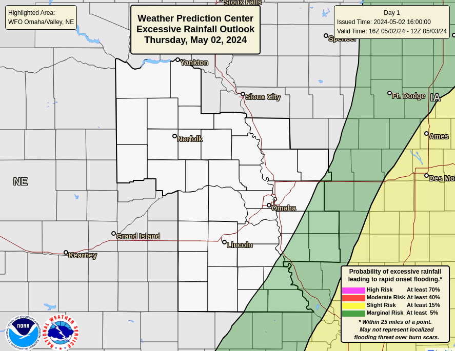 |
Day 2 Excessive Rain OAX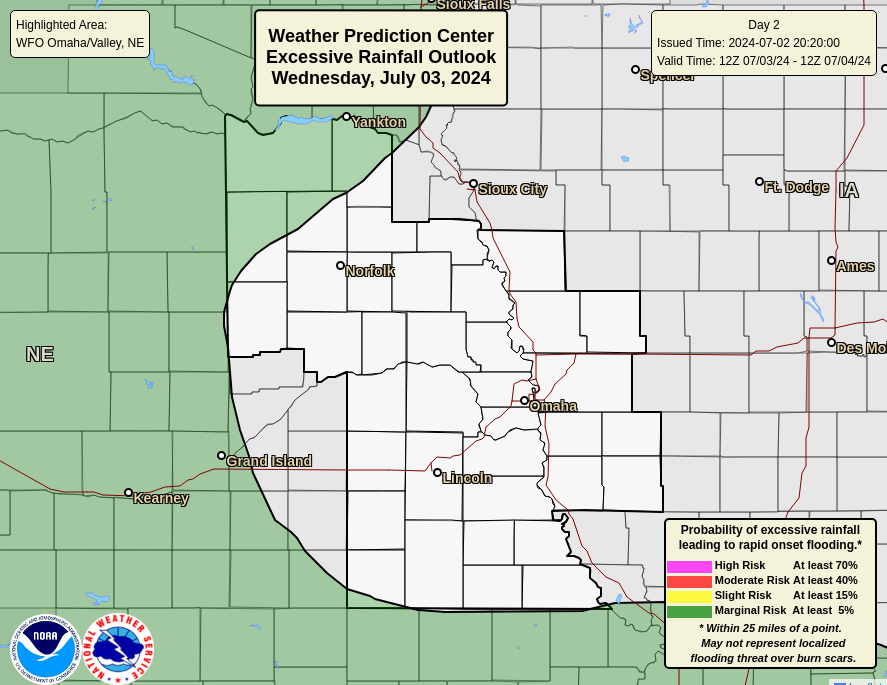 |
Day 3 Excessive Rain OAX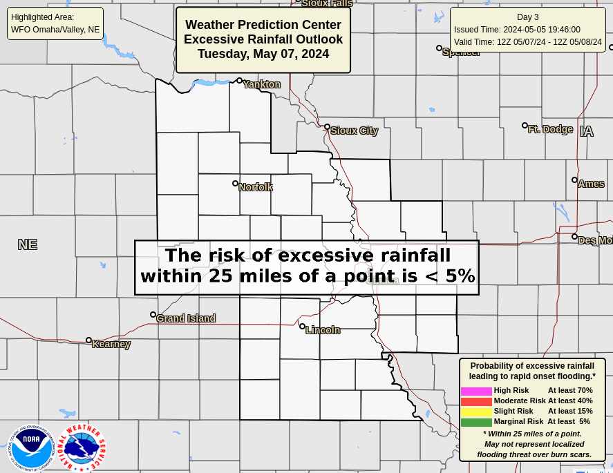 |
Day 1 Excessive Rain NE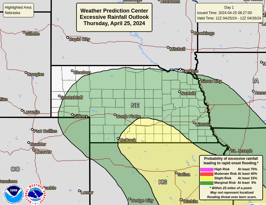 |
Day 2 Excessive Rain NE |
Day 3 Excessive Rain NE |
Day 1 Excessive Rain IA |
Day 2 Excessive Rain IA |
Day 3 Excessive Rain IA |
Day 1 Excessive Rain FEMA 7 |
Day 2 Excessive Rain FEMA 7 |
Day 3 Excessive Rain FEMA 7 |
| Day 4/5 QPF | 5 Day Total QPF | Day 6/7 QPF |
 |
 |
 |
| 6-10 Day Temperature | 8-14 Day Temperature | 3-4 Week Temperature |
 |
 |
 |
| 6-10 Day Precipitation | 8-14 Day Precipitation | 3-4 Week Precipitation |
 |
 |
 |
| Mid Month Temp | End of Month Temp | Three Month Temperature |
 |
 |
 |
| Mid Month Precipitation | End of Month Precipitation | Three Month Precipitation |
 |
 |
 |
| All Temperature | All Precipitation | |
 |
 |
|
| Drought Monitor | OAX Drought | Drought Outlook |
 |
 |
 |
| Nebraska Drought | Iowa Drought | Precip Needed |
 |
 |
 |
 |
 |
| Day 1 Snow(>= 4 inches) | Day 2 Snow(>= 4 inches) | Day 3 Snow(>= 4 inches) |
 |
 |
 |
| Day 1 Snow(>= 8 inches) | Day 2 Snow(>= 8 inches) | Day 3 Snow(>= 8 inches) |
 |
 |
 |
| Day 1 Snow(>= 12 inches) | Day 2 Snow(>= 12 inches) | Day 3 Snow(>= 12 inches) |
 |
 |
 |
| Day 1 Probability Ice (>= 1/4 inch) | Day 2 Probability Ice (>= 1/4 inch) | Day 3 Probability Ice (>= 1/4 inch) |
 |
 |
 |
Day 4
 |
Day 5
 |
Day 6 Snow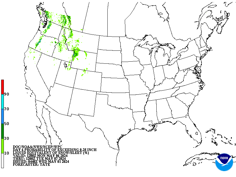 |
Day 7 Snow
 |
Overall WSSI for OAX - Winter Storm Severity Index - Archive
|
|||||||||||||||||||||||||||||||||
|
Day 1 Snow
 |
Day 2 Snow
 |
Day 3 Snow |
Day 4 Snow
 |
Day 1 Ice
 |
Day 2 Ice
 |
Day 3 Ice |
Day 4 Ice
 |


