
Heavy lake effect snow and gusty winds, including some local blizzard conditions, will continue into Thanksgiving Day across the Great Lakes then lingering through Friday night for Lakes Erie and Ontario. Confidence is increasing for another winter storm to develop over the northern and central Rockies Friday and track across the central Plains through the Midwest and Great Lakes this weekend. Read More >
...Highlights of 2021...
Daily Records: Record Low Temperatures: Lander, Temperature, 2022, Summary Rank - Driest to Wettest One Day Precipitation Records (inches): February: 0.27" on the 16th. March: 0.41" on the 20th. August: 0.24 on the 24th. September: 0.50" on the 15th. * 35 months of May with a trace or less of snowfall on record One Day Snowfall Records (inches): 73.5
Temperature
Precipitation
Snow
Winds

Element
Jan
Feb
Mar
Apr
May
Jun
Jul
Aug
Sep
Oct
Nov
Dec
Year
Average High
37.8
38.2
48.7
53.7
62.3
79.1
91
87.6
79.6
62.4
38.4
28.7
59.0
Mean High (1991-2020 Normals)
32.8
36.6
48.6
56.2
66.1
78
87.7
85.8
74.6
58.9
44.3
32.9
58.5
Average Low
13.4
10.8
22.1
26.9
38.3
47.7
58.7
56.6
49.5
34.7
15.2
4.1
31.5
Mean Low (1991-2020 Normals)
9.8
13.3
23.4
30.3
39.4
47.7
55.2
53.8
44.6
32
19.9
10.2
31.6
Average Temperature
25.6
24.5
35.4
40.3
50.3
63.4
74.9
72.1
64.5
48.6
23.8
16.4
45.0
Mean Temp (1991-2020 Normals)
21.3
25
36
43.2
52.8
62.8
71.5
69.8
59.6
45.4
32.1
21.6
45.1
Departure from Normal
4.3
-0.5
-0.6
-2.9
-2.5
0.6
3.4
2.3
4.9
3.2
-8.3
-5.2
-0.1
Rank: Coldest to Warmest
131 years of record (P.O.R 1892-2022)110
64
82
27
37
87
126
117
128
103
11
28
91

Highest Daily Maximum
54
62
73
72
81
92
100
99
99
76
66
51
100
Date of Occurrence
12
10
27
8,21
26
17,28
17
10
4
20
1
27
7/17
Lowest Daily Minimum
-6
-10
-15
11
29
34
51
50
40
19
-3
-32
-32
Date of Occurrence
6
24
10
13,14
10,22
15
2
15
10,11
26
30
22
12/22
Number of Days with:
Maximum >= 90°
0
0
0
0
0
5
23
10
8
0
0
0
46
Maximum <= 32°
7
10
7
2
0
0
0
0
0
0
8
17
51
Minimum <= 32°
31
28
26
25
4
0
0
0
0
10
29
31
184
Minimum <= 0°
3
7
3
0
0
0
0
0
0
0
1
8
22
Record High Temperatures Set or Tied
0
0
2
0
0
0
1
1
7
0
0
0
11
Record Low Temperatures Set or Tied
0
0
1
0
1
0
0
0
0
0
0
0
2
Temperature Ranks and Records:
Record High Temperatures:
March: 65 on the 20th and 72 on the 26th.
July: 100 on the 17th.
August: 99 on the 10th.
September: 98 on the 1st, 95 on the 3rd, 99 on the 4th (new monthly high), 96 on the 5th (tie), 94 on the 6th, 97 on the 7th and 92 on the 8th (tie).
March: -15 on the 10th.
May: 29 on the 22nd.
Top Ten Warmest Months of July on Record
Rank
Year
Average Temperature °F
1
2003
76
2
2006
75.9
3
2007
75.7
4
2012
75.5
5
1988
75.3
6
2022, 2002
74.9
7
2021, 1954
74.8
9
1966
74.7
10
2001
74.4
Top Ten Warmest Months of September on Record
Rank
Year
Average Temperature °F
1
2015
65.3
2
1990
64.8
3
2022
64.5
4
1979, 1969
63.8
5
1963
63.5
6
1998
63.4
7
2012
63.2
8
2001, 1952
63.1
9
1994
62.8
10
2021
62.7
Top Ten Warmest Years on Record
Rank
Year
Average Temperature °F
1
2012
49.0
2
1988, 1981
47.7
4
1934
47.6
5
1994, 2006
47.5
7
2021
47.4
8
1954
47.2
9
1999
47.0
10
2015
46.9
40
2022
45.0
Top Ten Coldest Years on Record
Rank
Year
Average Temperature °F
1
1912
39.9
2
1944
40.1
3
1920
40.2
4
1916, 1898
40.9
6
1895
41.0
7
1924
41.1
8
1913, 1899
41.2
9
1923, 1905
41.2
10
1993, 1929, 1922
41.4
91
2022
45.0
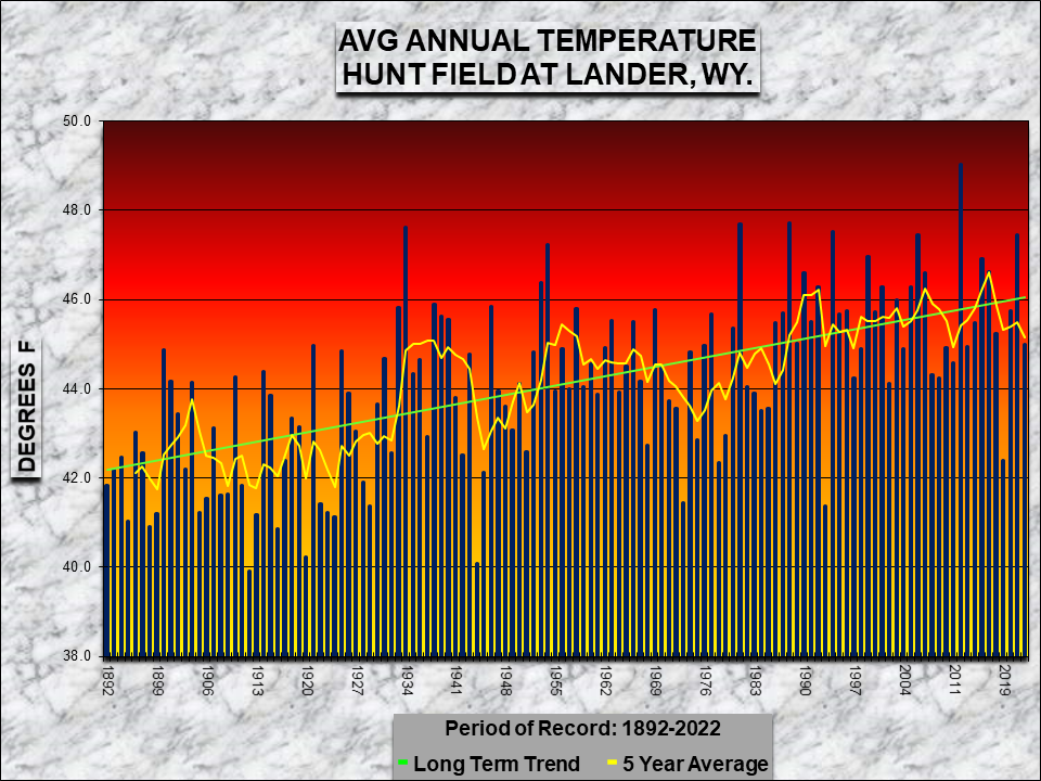
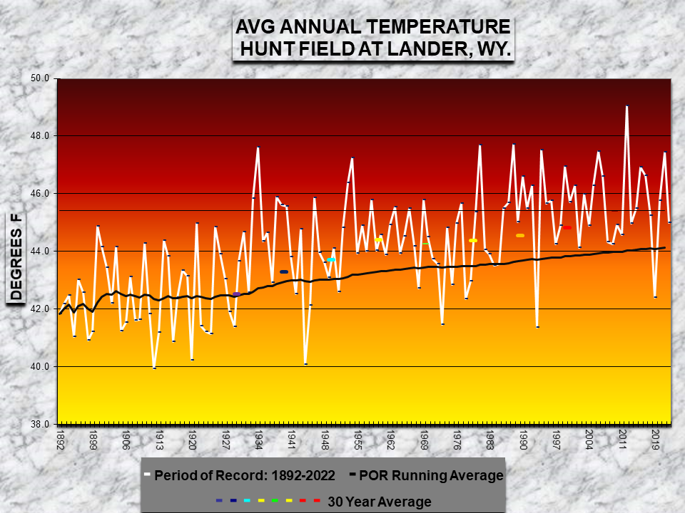
Average Annual Temperature for Period of Record - Click on Graph to Enlarge

Learn more about the National Weather Service's efforts to build a Weather-Ready Nation!

Element
Jan
Feb
Mar
Apr
May
Jun
Jul
Aug
Sep
Oct
Nov
Dec
Year
Total (inches)
0.71
0.74
1.89
1.34
4.13
T
0.38
0.53
1.5
0.31
1.07
1.32
13.92
Mean Precip (1981-2010 Normals)
0.51
0.7
1.29
2.07
2.68
1.08
0.59
0.52
0.98
1.4
0.78
0.63
13.23
Departure from Normal
0.20
0.04
0.6
-0.73
1.45
-1.08
-0.21
0.01
0.52
-1.09
0.29
0.69
0.69
Percent of Normal
139
106
147
65
145
0
64
102
153
22
137
210
105
131 years (P.O.R 1892-2022)101
79
109
43
106
3
53
80
101
15
95
117
76
Greatest 24-HR Total
0.33
0.41
0.54
0.69
0.88
T
0.21
0.25
0.72
0.27
0.35
0.76
0.88
Dates of Occurrence
5
15-16
6
22
3
Several
27
24-25
14-15
1
3
12-13
5/3
Number of Days with:
Precipitation >= 0.01
6
9
8
10
11
0
2
7
7
3
6
4
73
Precipitation >= 0.10
3
3
6
4
7
0
2
1
5
1
5
4
41
Precipitation >= 1.00
0
0
0
0
0
0
0
0
0
0
0
0
0
Days with Thunderstorms
0
0
0
0
2
3
7
5
3
0
0
0
20
Daily Precipitation Records Set or Tied
1
1
1
0
0
0
0
1
1
0
0
0
5
Precipitation Ranks and Records:
January: 0.33" on the 5th.
Top Ten Driest Months of June on Record
Rank
Year
Precipitation (inches)
1
1956, 1971
0
2
2022
Trace
3
1933
0.02
4
2006
0.03
5
1942, 1981, 2012
0.04
6
1924, 1980, 2013
0.05
7
1954
0.09
8
1896, 1930
0.12
9
1917, 1929
0.13
10
1906, 1938
0.14
Top Ten Driest Years on Record
Rank
Year
Precipitation (inches)
1
2001
5.30
2
1954
6.41
3
2012
6.60
4
1902
7.25
5
2020
7.33
6
2006
7.42
7
1988
7.63
8
1939
7.95
9
2002
8.09
10
1914
8.32
56
2022
13.92
Top Ten Wettest Years on Record
Rank
Year
Precipitation (inches)
1
1957
21.89
2
1923
21.56
3
2016
21.29
4
1941
20.66
5
1912
20.00
6
1947
19.70
7
1995
19.68
8
1944
19.57
9
1973
19.30
10
1908
19.22
76
2022
13.92
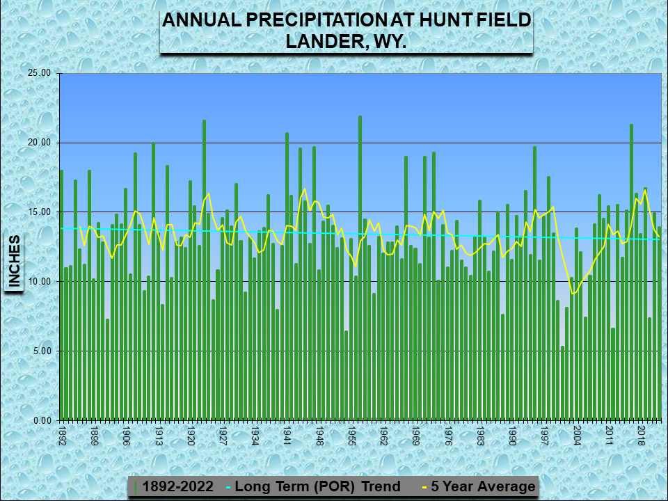
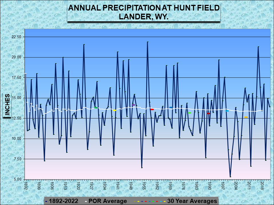
Annual Precipitation for Period of Record - Click on Graph to Enlarge

Learn more about the National Weather Service's efforts to build a Weather-Ready Nation!

Element
Jan
Feb
Mar
Apr
May
Jun
Jul
Aug
Sep
Oct
Nov
Dec
Year
Total (inches)
9.9
10.5
21.2
2.9
T
0
0
0
0
T
14.2
14.8
73.5
Average Snowfall
8.2
12.1
14.4
16.4
4.5
0.1
0
0
1.5
10.5
10.6
9.3
87.6
Departure from Normal
1.7
-1.6
6.8
-13.5
0
-0.1
0.0
0.0
-1.5
-10.5
3.6
5.5
-14.1
Percent of Normal
121
87
147
12
0
0
0
0
0
0
134
159
84
Rank - Least to Most
131 Years (P.O.R 1892-2022)102
83
103
18
37
NA
NA
NA
67
21
98
109
49

Greatest 24-HR Total
3.4
4
6.1
1
T
0
0
0
0
T
3.6
5.7
5.7
Dates of Occurrence
27
16
6
23
9,20
NA
NA
NA
NA
23
28
21
12/21
Number of Days with:
Snowfall >= 1.0 inch
3
4
6
1
0
0
0
0
0
0
6
4
24
Daily Snowfall Records Set or Tied
0
1
1
0
0
0
0
0
0
0
0
0
2
* 64 months of September on record with no snowfall.
Snowfall Ranks and Records:
February: 4.0" fell on the 16th.
March: 3.7" fell on the 5th
Top Ten Snowiest Years on Record
Rank
Year
Snowfall (inches)
1
1973
199.9
2
1975
160.7
3
1983
159.6
4
1967
154.6
5
1959
150.4
6
1971
148.3
7
2013
138.0
8
1978
128.1
9
1920
127.9
10
1892
125.1
83
2022
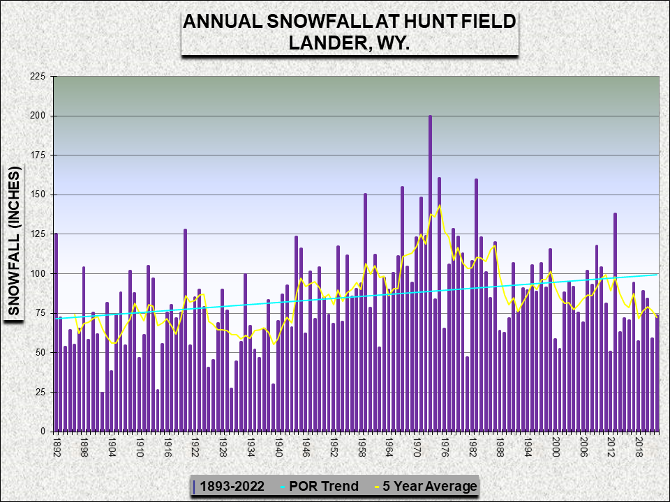
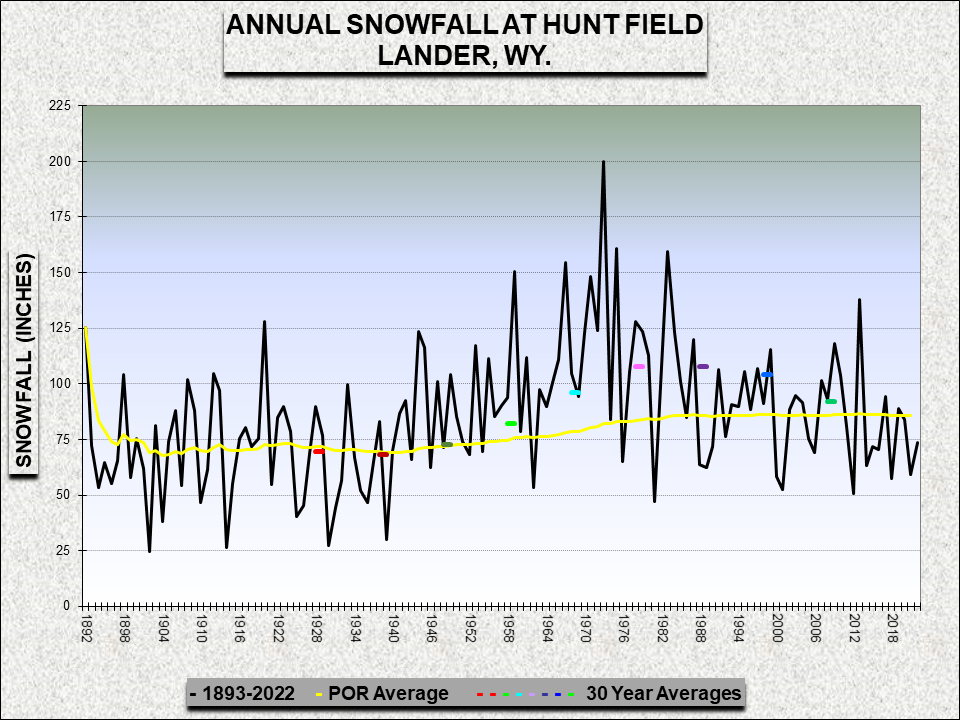
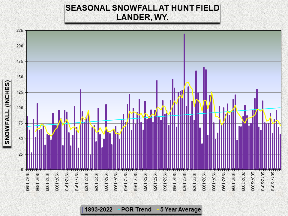
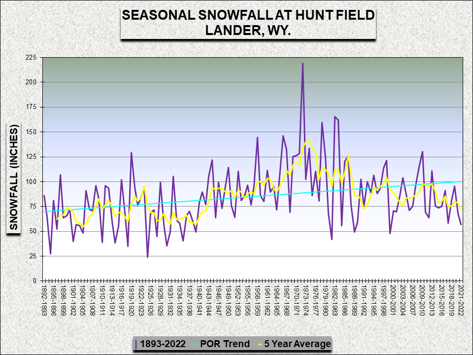
Annual and Seasonal Snowfall for Period of Record - Click on Graph to Enlarge

Learn more about the National Weather Service's efforts to build a Weather-Ready Nation!

Element
Jan
Feb
Mar
Apr
May
Jun
Jul
Aug
Sep
Oct
Nov
Dec
Year
Average Speed (MPH)
5.1
5.7
6
8.2
8
7.9
8.1
6.2
6.2
4.6
5.5
5.8
6
Maximum 3-sec Gust
58
47
50
58
52
56
74
52
55
70
59
66
74
Direction (degrees)
350
350
200
310
250
240
310
300
210
200
210
230
310
Date of Occurrence
31
5
28
5
16
17
24
11
13
22
7
1
7/24
Number of Days with:
2-Minute Wind >50 mph
0
0
0
0
0
0
0
0
0
0
0
0
0
Peak Wind >50 mph
2
0
1
4
2
3
4
1
3
1
2
2
25
Peak Wind >65 mph
0
0
0
0
0
0
1
0
0
1
0
0
2

Learn more about the National Weather Service's efforts to build a Weather-Ready Nation!