
Showers, along with a few strong to severe thunderstorms, are expected from the Great Lakes, New England and southward into the Ohio and Tennessee Valleys. In the wake of this system, a stronger storm is expected to track from the Pacific Northwest, Plains and through the Eastern U.S. this weekend. Strong winds, showers and a larger drop in temperatures are expected this weekend into Monday. Read More >
Links | Map | Warnings, Radar, & Satellite | Fire & Thunder Forecasts
| Fuels and Fire Danger Maps
 |
 |
 |
|
Click Image To Enlarge This image shows the expected peak wind gusts over the next 12 hours. |
Click Image To Enlarge This image shows the expected peak wind gusts over the 12 hour period ending at the time stated in the header.
|
 |
 |
|
Click Image To Enlarge This image shows the expected peak wind gusts over the 12 hour period ending at the time stated in the header.
|
Click Image To Enlarge This image shows the expected peak wind gusts over the 12 hour period ending at the time stated in the header.
|
 |
 |
|
Click Image To Enlarge This image shows the expected minimum relative humidity today.
|
Click Image To Enlarge This image shows the expected minimum relative humidity tomorrow. |
Current Warnings, Radar, and Satellite- Click to Enlarge
 |
 |
|
|
Click Image to Enlarge Teton Pass, looking East |
|
|
|
|
|
 |
 |
 |
|
|
|
Storm Prediction Center Critical Fire Areas and Thunderstorm Forecasts - Click to Enlarge
|
|
|
|
 |
 |
 |
|
|
|
|
 |
 |
 |
|
|
|
|
 |
 |
 |
|
|
|
|
|
|

|

|

|

|

|
|
|
|
|
|
|
 |

|
 |
 |
 |
|
|
|
|
|
|
 |

|
 |
 |
 |
USFS Fire Danger Graphics and Fuels - Click to Enlarge
|
|
|
|
 |
 |
 |
|
|
|
|
|
 |
 |
 |
 |
|
|
|
|
|
 |
 |
 |
 |
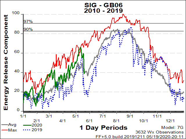
| BT National Forest ERC Fuels Graph |
|
|
 |
 |
 |
Return to NWS Riverton Homepage
 |
Building a Weather-Ready Nation |


.png)


