Cold temperatures will continue across much of the eastern U.S. into today. Heavy lake effect snow continues into today east of Lakes Erie and Ontario. Two Pacific cold fronts will cross the Pacific Northwest early this week followed by another atmospheric river. Heavy rain and gusty winds are expected through midweek, with the potential for renewed urban and river flooding. Read More >
 |
Building a Weather-Ready Nation |
Flood Overview | Radar and Data | Aftermath Photos
Between 11:30 p.m. MDT August 26, 2002 and midnight, an intense thunderstorm developed along the eastern foothills of the Bighorn Mountains in southern Johnson County, Wyoming. Easterly low-level outflow winds from large thunderstorms over the High Plains fed moist air into the storm. Also, weak southwest winds in the upper atmosphere helped lift the moist air feeding in at the surface but kept the storm nearly stationary - for more than 6 hours!
 Around 1:00 a.m. on Tuesday, August 27, the National Weather Service Doppler radar in Riverton, Wyoming had estimated rainfall of 3 inches along the tributaries of the Middle Fork of the Powder River, from 10 to 14 miles southwest of Kaycee. Soon after, at 1:05 a.m., NWS Riverton staff issued a flash flood warning for southern Johnson County. The warning specifically mentioned Murphy, Willow, and Buffalo creeks south of Kaycee as well as Lone Bear Road. The heavy rain continued through the night, with most of the rain falling between midnight and 4:00 a.m. on August 27. The storm had weakened considerably by 7:00 a.m. Approximately 66 square miles were estimated to have received at least one inch of rainfall. Radar estimates of storm total precipitation at 6:00 a.m. included approximately 12 square miles of 6+ inches with a peak estimate of 7.4 inches. Nearby manual rain gauge measurements supported the accuracy of the radar rainfall estimates. The typically semi-arid western environment around Kaycee only receives 12 to 14 inches of precipitation annually.
The incredible amount of precipitation from this storm in such a short period of time caused flash flooding across southern Johnson County. The first report of damage was water over Barnum Road about nine miles west of Kaycee at 2:30 a.m. Law enforcement reported the Middle Fork of the Powder River, which runs through Kaycee, two feet below bankfull at 5:10 a.m. and at bankfull by 6:20 a.m. However, by 7:15 a.m. the river was out of its banks and four feet of water was reported on Nolan Avenue (Main Street) in Kaycee. A couple were rescued from a home due to water too deep to drive through, and a front-end loader moved a woman in a wheelchair to safety. At 9:25 a.m., county officials reported one home destroyed, with 12 heavily damaged. A final count provided by the Wyoming Emergency Management Agency on Wednesday, August 28, reported flood damage to 19 trailers, 22 houses, and 12 of Kaycee's 15 businesses. One hotel was broken in three pieces, with one piece carried 75 yards, and the other two pieces deposited a few hundred yards away on the opposite side of the Middle Fork of the Powder River. Also affected were the post office, town museum, conservation district office, and the telephone company.
A damage survey conducted by the NWS Riverton Service Hydrologist and Warning Coordination Meteorologist determined that normally tranquil Murphy Creek in southern Johnson County was at one point 300 yards wide and approximately 20 feet deep near Lone Bear Road. This creek eventually compromised the safety of the northbound Interstate 25 bridge over Murphy Creek. Northbound traffic was being diverted until a crossover was constructed for northbound travelers. The Natural Resources Conservation Service estimated the peak discharge of Murphy Creek at 13,500 cubic fee per second (cfs). Average mean discharge of the creek is 1.5 cfs. Total damage estimates ranged from $3 to $4 million.
Convection earlier in the evening had left a rain-cooled airmass over central Johnson County. This rain likely contributed to a nearly stationary boundary establishing itself over southern Johnson County. It is thought that this boundary became anchored to the higher terrain of the Bighorn Mountains and possibly played a role in the heavy rainfall. Flow aloft from the southwest overran this boundary triggering repeated thunderstorms over the same region for several hours.
.png) |
 |
 |
| One hour rainfall estimates at 1:04 a.m. MDT, Tuesday, August 27, 2002. Yellow blocks depict 2"+ and orange blocks indicate greater than 3" rainfall amounts, respectively. At this time the NWS Riverton issued the flash flood warning for southern Johnson County. Click for larger image. |
Infrared satellite image at 2:00 a.m., Tuesday, August 27, 2002. The blue cloud tops outlined with the yellow oval indicate cloud tops colder than -60C. This helped the meteorologist know that these were very deep (tall) thunderstorms, especially at 2 o'clock in the morning! Click for larger image. |
Total rainfall estimated by the NWS Riverton WSR-88D radar during the morning of Tuesday, August 27, 2002. The white circles are locations where manual rainfall observations were made. The manual measurements correlated very well with radar estimates which exceeding 6" across a large area. Click for larger image. |
The heavy rainfall came fast, with over 3 inches falling in the first 60 to 90 minutes, and upwards of 5 inches falling over the course of two-and-a-half hours. The infrared, or IR, satellite imagery gave strong indications of a peristent area of cold cloud tops over southwest Johnson County during the early morning hours. These cold cloud tops, indicating tall thunderstorms, gave further support to the idea that heavy rainfall was indeed occurring. Thunderstorm activity gradually decreased after about 3 a.m. with only around one additional inch of rainfall in the warned area. That brought overall rainfall totals to over 2.5 inches across a wide area with several square miles receiving an estimated 6 inches or more.
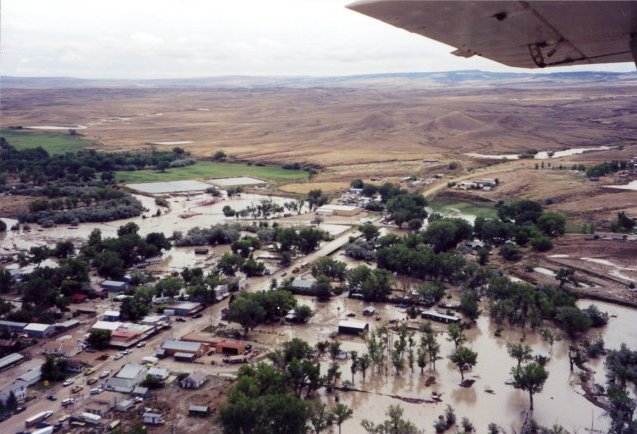 |
Aerial view of Kaycee looking south on the day of the flash flood, August 27, 2002. -Photo courtesy of Cheryl Summer- |
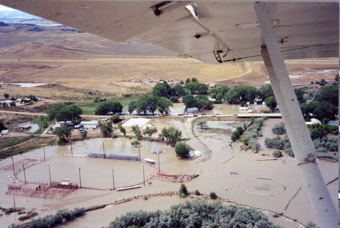 |
Aerial view of Harold Jarrard Park on the south side of Kaycee/Middle Fork of the Powder River as it looked on the day of the flash flood, August 27, 2002. -Photo courtesy of Cheryl Summer- |
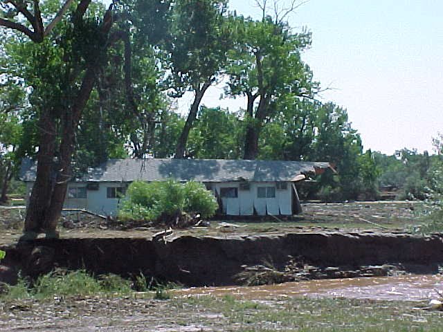 |
Riverside Hotel on the opposite side of the Middle Fork of the Powder River in Kaycee from where it was located. This photo was taken the day after the flash flood. The hotel was separated into three pieces. |
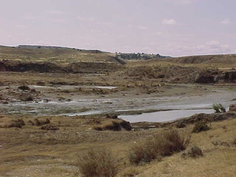 |
The Murphy Creek drainage the day after the flash flood. Murphy Creek was estimated to be 300 yards wide and 20 feet deep at one point upstream of the I-25 bridge. |
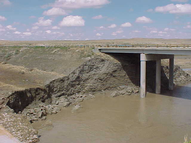 |
Northbound I-25 bridge over Murphy Creek. Banks were eroded and the bridge was closed until stabilization of the bridge supports could occur. |
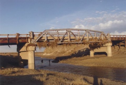 |
TTT Ranch Road bridge in the Murphy Creek Drainage south of Kaycee the day after the flash flood. Note the debris caught on the bridge. |
 |
Chris Jones, far right, NWS Riverton Warning Coordination Meteorologist, addresses the crowd at the then-new Kaycee Visitor's Center at the dedication of the Kaycee All Hazards NOAA Weather Radio on August 27, 2003, the one year anniversary of the flash flood. |
 |
Learn more about the National Weather Service's efforts to build a Weather-Ready Nation! |


.png)