| A Review of Weather in 2003 |
The year 2003 was rather benign weather-wise in Tallahassee and surrounding areas. However, there were a few notable exceptions. As can be seen in Figure 1 (below), temperatures were well below normal during the first and last months of the year with extended periods of above normal temperatures during portions of the spring and fall. The summer months were unusually mild with temperatures averaging below normal for most of the four-month period from June through September. Figure 2 (below), shows that the year started out very dry. However, frequent heavy rains in February and early March erased the initial deficit. The spring months were typically dry with the largest rainfall deficit of the year occurring in late May. Unlike many recent summers, rains were plentiful throughout the season, the main reason for the reduction in summertime heat. By early August, we were running a surplus. Autumn is also typically rather dry, but rains occurred frequently enough this year to maintain the surplus, despite below normal rainfall in December. The annual rainfall total was 65.33 inches in Tallahassee, which is 2.12 inches above normal. This is the most rainfall in Tallahassee in any year since 1994, despite the fact that there was no direct impact locally from any tropical storms. Following are some of the weather highlights that occurred in the NWS Tallahassee County Warning & Forecast Area in 2003.
Off to a Cold & Dry Start
The year started out very cold and dry (see Figures 1 & 2, below). Morning low temperatures were below freezing in Tallahassee on 18 of the 31 days of January. Eight of these were hard freezes. In fact, the average daily minimum temperature for the month was just a fraction of a degree above the freezing mark. Temperatures dipped below 20 degrees three times. The low of 18 on the 24th was the coldest temperature of the year in Tallahassee. The high temperature that day was just 43 degrees, the coldest afternoon of the year. The 24th was quite cold across the entire region. The temperature even got down to 20 at Apalachicola, FL, that morning with an afternoon high temperature of just 39. Other temperatures around the region that morning include 19 at Panama City, FL (a record for the date); 17 at Valdosta, GA; 14 at Dothan, AL; and 13 at Albany, GA. Despite the frequent cold spells, no daily minimum records were set during the month at Tallahassee. However, a record low of 27 was established at Panama City on the 25th, and Albany set a record low of 16 on the 18th. January 2003 was the 6th coldest January of all time and the 10th coldest month overall.
January was also quite dry. Measurable rainfall occurred on only 5 days. The monthly total was just 0.34 inches, which is over 5 inches below normal. This makes January 2003 the 4th driest of all time and the driest month of 2003.
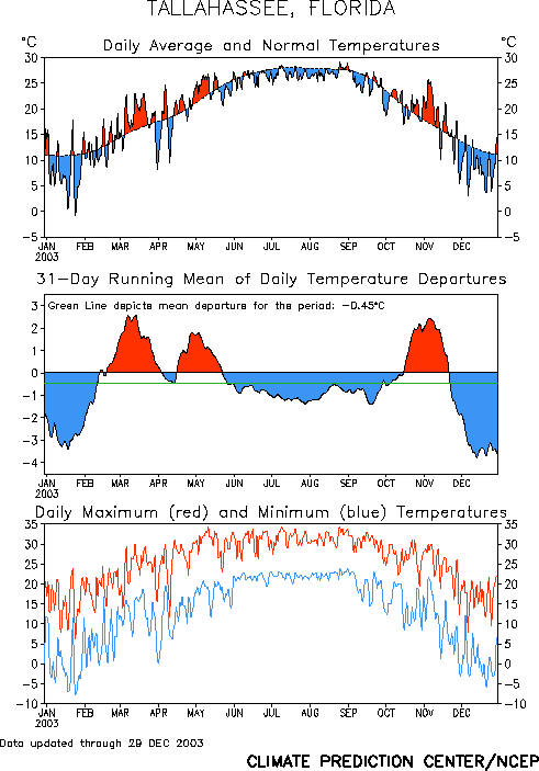
Figure 1. Temperatures in Tallahassee during the year 2003.
Warm & Wet Spring - March Floods
February saw a transition to a milder and wetter weather pattern. Temperatures dipped to freezing or lower only three times in Tallahassee with the coldest temperature of the month just 30 degrees. The month averaged exactly normal temperature-wise in Tallahassee with near-normal temperatures elsewhere across the region as well. No daily records were set during the month. Measurable rainfall occurred on 11 days during the month in Tallahassee. The monthly total of 6.83 inches was over two inches above normal. March was quite warm with no freezing temperatures recorded during the month. The mercury cracked 80 for the first time on March 6th with a high of 85 at Tallahassee and 84 at Valdosta. The highest temperature of the month was 86 in Tallahassee on the 13th. Temperatures averaged some 3 to 6 degrees above normal for the month across the region, but there were no daily maximum records set. Interestingly, the coldest day of the month was the 31st. On April 1, the Tallahassee Regional Airport recorded the last freezing temperature of the season with a low of 32.
Heavy rains were frequent in March with 5.5 to 7.5 inches of rain falling during the month across most of the region. However, there were locally higher amounts.
From March 4th-9th, periods of heavy rainfall, which ranged from three to six inches in Leon County to 14 inches in Taylor County, flooded many roads, homes and poor drainage areas. Residents along Munson Slough in northern Wakulla County were forced to evacuate as flood waters seeped into their homes. Widespread flooding forced many families in Taylor County to evacuate to motels, while others were isolated by the rising flood waters. Many septic tanks and water wells were damaged. Some residents along the swollen Apalachicola and Ocklockonee rivers in Liberty County experienced minor flooding. Minor to moderate flooding occurred near the Aucilla and Suwannee river basins. Flood waters seeping into homes in Steinhatchee Springs forced residents to evacuate to higher ground. Local states of emergency were declared in Leon, Wakulla, Taylor, Liberty and Lafayette counties.
On March 20th, torrential rains were streaming in off the Gulf of Mexico into Panama City on a night that saw deadly tornadoes further northeast in Georgia (see below). In a three-hour period, five inches of rain fell in parts of Panama City, FL, causing significant flooding of streets, intersections and low-lying areas. Several cars were stranded along a flooded stretch of U.S. Highway 98. Officially, Panama City recorded 9.31 inches of rain for the month, over a third of which fell on the 20th alone.
April saw a return to near normal temperatures, and it was drier than normal in most areas. The exception was Dothan, which received nearly 8 inches of rain during the month, with over 3 inches occurring in a 24-hour period on the 7-8th.
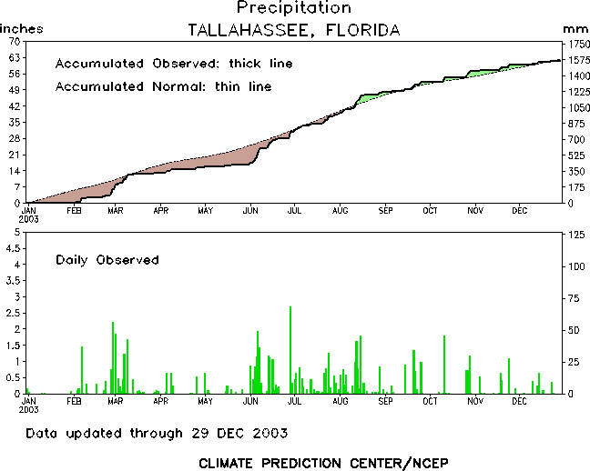
Figure 2. Rainfall in Tallahassee during the year 2003.
Wet Summer with Mild Temperatures
The summer months were notable for their lack of any extreme heat. The maximum temperature of the season in Tallahassee was just 94 degrees, which occurred on May 11th, July 9th, and August 25th. The only area to exceed 95 degrees was Valdosta, which reached 96 on August 16th. Apalachicola reached 90 degrees only 7 times during the season with the maximum of 91 occurring on August 14th. Temperatures reached or exceeded 90 degrees in Tallahassee on just 11 days each in May and June and on fewer than half the days in July and August. The average daily maximum temperature was just 87.0 degrees in May, 87.5 in June, 88.8 in July, and 89.0 in August. No daily record temperatures were set during the summer months.
The main reason for the mild temperatures was the abundant cloud cover and frequent rains, which occurred throughout the summer, despite the absence of any tropical systems. The wettest month was June with 14.30 inches measured at Tallahassee, more than double the normal rainfall. This was the 6th wettest June on record. Similar amounts of rain fell in Apalachicola with 4.52 inches falling on the 20th alone. Rainfall was only slightly above average in July, but only 8 days were rain-free. In August, 10.45 inches of rain fell in Tallahassee. This is nearly 3.5 inches above normal. Over a foot of rain fell in Panama City with 3.28 inches on the 12th alone. The combined rainfall in Tallahassee for the summer months of June, July and August was 32.33 inches. This amount represents more than half of the normal annual average rainfall in the city and is the 5th wettest summer on record.
Autumn Warm, but not Stormy
Unlike the last several seasons, no tropical systems directly impacted the Florida Big Bend or Eastern Panhandle. Tropical Storm warnings were posted for parts of the Big Bend coastline for Tropical Storm Henri, but impacts were minimal as the system weakened to a depression before making landfall well down the coast near Clearwater on the morning of September 6th. The fall months were also notable for the lack of severe weather. Typically, the region sees a secondary peak in severe weather activity in the fall, particularly November. However, there were no such events this year. Temperatures were above normal for most of the season. In November, temperatures averaged 2.6 degrees warmer than normal in Tallahassee. The first 13 days of the month were all warmer than normal with several record daily maximums tied or broken. In Tallahassee, the temperature reached 86 on the 4th, 6th, and 7th, tying or breaking a record each day. Apalachicola tied or broke records on the 6th, 7th and 8th. Panama City tied records on the 1st and 2nd. Albany, GA, tied their record temperature of 87 on the 5th. The normal date of the first freezing temperature at Tallahassee Regional Airport is November 6th. This year, the first freeze did not occur until the 29th.
Cold and Dry December
December 2003 was dominated by persistently cool weather. Only one of the first 28 days averaged warmer than normal. A mild spell at the end of the month kept this December out of the list of top five coldest. Still, temperatures averaged 5.4 degrees colder than normal. Temperatures dropped to the freezing mark or lower on 15 days during the month, but there were only two hard freezes, on the 20th and 21st.
Severe Weather
Typically, this part of the country sees a peak in severe weather activity during the spring months with a secondary maximum in November. Through summer, isolated severe storms are possible on almost any day, although large outbreaks are much less common. Occasionally severe weather occurs in the winter months, and some of these can be major outbreaks. In 2003, there were a couple of notable severe weather episodes during the peak season, with frequent mainly isolated activity in the summer. There was only one severe weather report during the fall, and no severe weather at all during the winter months of January and December. Monthly summaries of severe weather occurrences in 2003 can be obtained by clicking the links below.
January | February | March | April | May | June | July | August | September | October | November | December
January
- No severe weather was reported during the very dry month of January.
February
- The first significant severe weather episode of the year occurred across the Southeastern U.S. on February 16th. Over the eastern Florida Panhandle, a tornado briefly touched down about 1/2 mile from Tyndall AFB at 1100 UTC (500 CST). It propelled a minivan into an administrative building and also tore off portions of the roof. Nearly three dozen private and military vehicles were damaged. The tornado also destroyed a trailer and fence. About a half hour later, another tornado touched down and damaged several homes in Vernon, FL. Most of the damage was to siding, windows and roofs. Trees and power lines were also felled. A few minutes after that, a waterspout came ashore on the north side of Port St. Joe in Gulf County and damaged about a dozen homes. A tree fell on a house; a carport collapsed onto a vehicle; and the front porch of a beach home was blown onto another vehicle. Numerous trees and power lines were downed. Later in the morning, a supercell developed over Gadsden County in Florida, and became tornadic over far Southwest Georgia. The tornado touched down on Ridge Rd. in northern Grady County, just south of the Grady-Mitchell County line. The tornado continued into Mitchell County, just north of County Route 262. The worst damage occurred between this route and Wade Rd. The tornado destroyed three mobile homes and severely damaged three frame homes. Several other mobile and frame homes sustained minor damage. This tornado followed a track very close to that taken by the deadly F3 tornadoes that swept the area in February 2000. Fortunately, there were no fatalities associated with this event. For additional details, including radar imagery, read our online write-up on this event.
- Later in the month, on the 22nd, severe thunderstorm wind gusts knocked down trees and power lines in Ozark and Dothan, AL, and in Albany, GA.
March
- In March, there were several severe weather episodes, including the biggest flood events of the year (see above) and the deadliest tornado. On the 9th, a thunderstorm produced dime-sized hail in the Coffee County town of Goodman in Southeast Alabama.
- On the morning of the 13th, hail was observed in the nearby town of Abbeville, the county seat in Henry County. In Southwest Georgia, hail was reported in Thomas County at Boston. Thunderstorm wind gusts downed several trees in Lanier County, 5 miles east of Lakeland. During the afternoon, nickel-sized hail fell in Terrell County at Dawson.
- The next afternoon, there was another hailer in Coffee County, AL, with nickel sized hail covering the ground southwest of Enterprise.
- On the 17th, afternoon thunderstorms produced damaging wind gusts in South Central Georgia. Trees and power lines were downed in Valdosta, near Nashville, and across much of Cook County.
- The largest severe weather outbreak of the year occurred on March 20th. Things got started late the previous evening when thunderstorm wind gusts knocked a tree onto a Mobile home in Walton County at Choctaw Beach, FL, at 1120 PM CST. Wind gusts downed trees and power lines just south of Hartford in Geneva County, AL. A storm that eventually became tornadic initially came ashore in extreme southwest Bay County, Florida, at approximately 0730 UTC (1:30am CST). The cell rapidly developed a circulation and may have become tornadic in the northern part of the county. The storm did destroy a home in Fountain around 0807 UTC (2:07 am CST) before continuing across the northeastern Florida Panhandle into Jackson County, where the first confirmed tornado touchdown occurred. An aerial survey revealed an 8-mile discontinuous damage path extending from two miles west of Grand Ridge to five miles north of Sneads. This tornado injured four people and was on the ground for approximately 15 minutes. The tornado apparently lifted before the storm entered extreme Southwest Georgia. Nevertheless, the storm was still potent enough to damage several homes, some in the Seminole County town of Reynoldsville, and a few others (including a church) in the Decatur County town of Mount Pleasant. The storm turned deadly as it crossed into Mitchell County. A tornado descended once again and reached F3 strength on the Fujita scale. It was on the ground for 25 minutes, producing a damage path of 19 miles. The tornado produced extensive damage along its path. Dozens of mobile and frame homes were destroyed. In Camilla alone, there were over 150 homes damaged. Unfortunately, four people were killed in this area, with over 200 sustaining injuries. Unbelievably, another F3 tornado followed nearly this same track, within about 100 yards, back in February 2000. Some residents in Camilla rebuilt homes destroyed by the tornado three years earlier, only to find their new homes damaged or destroyed by this tornado. The twister continued northeast into Worth County where two more people were killed and many more homes were damaged or destroyed. Damage was also reported further northeast in Ben Hill County, where an elementary school and church steeple were damaged. States of emergency were declared in both Mitchell and Worth Counties. For additional details, including aerial photographs and radar imagery, read our online write-up on this event. The final severe weather occurrence of the day occurred during the afternoon when a thunderstorm wind gust caused some damage in Jefferson County, FL, about 5 miles west of Monticello.
April
- There were three relatively minor severe weather episodes in April. On the 5th, a thunderstorm produced golf-ball size hail in Calhoun County, FL, at Blountstown, and across the river in Liberty County at Bristol.
- On the 7th, thunderstorm wind gusts knocked several tress down across the intersection of SRs 93 and 111, 3 miles north of Cairo, GA, in Grady County.
- On April 25th, a weak F0 tornado briefly touched down in New Harmony in Walton County, FL, at 4:20 AM CST. A barn and several homes were damaged. Straight-line winds downed trees in Paxton, also in Walton County. In southwest Georgia, thunderstorm wind gusts knocked down trees near the Decatur County Airport, 5 miles north of Bainbridge. During the mid afternoon, two waterspouts were spotted near Horseshoe Beach in Dixie County, FL. At 10:05 EST, a waterspout came ashore near Windward St. on Cape San Blas in Gulf County, FL. The weak tornado uprooted trees and power lines, and damaged a dozen homes as it moved northeast through Port, Leeward, and Angle Fish Streets. During the evening, thunderstorm wind gusts damaged an Ozark convenience store in Dale County, AL. At midnight on the 26th, dime-size hail was reported at Hilton in Early County, GA. A few minutes later, golf-ball size hail was reported in Miller County at Colquitt. A third hail report was received from Cairo in Grady County later that night.
May
- Severe weather was reported on four separate occasions in May, with one fairly widespread outbreak in South Central Georgia. On May 1, we received a report of penny-size hail just east of the Tallahassee Regional Airport in Leon County, FL.
- The evening of May 2nd-3rd saw fairly widespread wind damage across South Central Georgia, beginning shortly after 10:00 PM EST and continuing until just after midnight. Numerous trees and power lines were downed across many parts of the following counties: Ben Hill, Irwin, Turner, Worth, Tift, Berrien, Lanier, Lowndes, Brooks, and Thomas. In addition to this damage, several car ports and sheds were damaged in Ben Hill County, while a tree fell on an Ocilla house in Irwin County.
- On the 11th, there was a single report of wind damage in Ben Hill County at Queensland.
- A week later, on the afternoon of the 18th, golf-ball size hail was reported on the east side of the city of Madison, FL, in Madison County. In Cook County, GA, penny-size hail was reported across many parts of the county with wind damage at Lenox and Sparks.
- Finally, on the last day of the month, an elderly man drowned in rough surf at the St. Joseph Peninsula State Park in Gulf County, FL.
June
- Severe weather reports were rather sporadic during June. On the 8th, at least 28 people were rescued from rough surf off the Walton County beaches from Inlet Beach to Miramar Beach, FL. Unfortunately, six people drowned.
- On the 15th, lightning damaged the dome of a Boston church in Thomas County, GA.
- The next day, thunderstorm wind gusts downed several trees across Lowndes County, GA, while torrential rains flooded several county roads and businesses in Ben Hill County, GA.
- From May 18th-21st, heavy rainfall caused rapid rises on the Munson Slough in southern Leon County, FL, which resulted in flooding of streams, drainage areas, and a few homes.
- On the 23rd, several waterspouts were spotted by the public off the Walton County coast west of Seaside and just southeast of San Destin, FL.
- On the 30th, an F1 tornado touched down near Highway 62 just west of Blakely in Early County, GA. The twister lifted a mobile home off its foundation, destroyed a barn, damaged several homes, and uprooted several trees. Also on the 30th, torrential thunderstorm rains flooded numerous streets in Headland, AL (Henry County).
July
- In July, a weak tornado touched down on the 1st just southwest of Hartsfield, GA, in Colquitt County. It downed several trees and power lines, and destroyed a few mobile homes. Three barns were damaged. A truck was totaled by a fallen tree and a trampoline was wrapped around a pine tree.
- On the 2nd, torrential rains from the remains of Tropical Storm Bill caused extensive flooding throughout Bay County, FL. As many as 40 homes were damaged by flood waters. Streets in Lynn Haven, Springfield and Parker were closed. Several residents of an apartment complex in Parker had to be rescued by boat. In addition, a dozen swimmers were rescued from the rough surf at Panama City Beach. Two swimmers drowned.
- On the morning of the 11th, a waterspout was reported just offshore of Dekle Beach in Taylor County, FL. Around midday, thunderstorm wind gusts knocked down several trees and power lines in Kinsey, AL (Houston County). That afternoon, lightning struck a city utility power substation on the northeast side of Tallahassee, FL. Nearly 5,000 customers were without power. Damage to the substation was severe, and forced city electric crews to establish a mobile substation.
- On July 16th, penny-size hail was reported at Choctaw Beach in Walton County, FL. Several trees were downed by a thunderstorm wind gust in the same area.
- The next afternoon, nickel-size hail was reported at Greenhead in Washington County, FL. Thunderstorm wind gusts downed trees and power lines at many locations across Northwest Florida including Pinetta in Madison County, Red Bay in Walton County, Ebro in Washington County, and in several locations across Jackson County.
- On the 23rd, Pinetta, FL, once again experienced thunderstorm wind gusts strong enough to knock over several trees. Tree damage also occurred in Jefferson County, FL, near Waukeenah, and in southeast Lowndes County, GA, near Lake Park and Indianola. A waterspout was observed on the Apalachicola Bay that afternoon as well.
- On the 29th, dime- to quarter-size hail was reported in Worth County, GA, at Bridgeboro. Thunderstorm wind gusts felled several trees across Madison County, FL, as well as in Valdosta, GA (Lowndes County), and 7 miles southeast of Albany, GA, in Dougherty County. In Decatur County, GA, numerous trees and power lines were downed in the towns of Attapulgus and Climax. A roof was blown off a home along Highway 27 about 4 miles north of Attapulgus.
August
- On the first day of August, thunderstorm wind gusts downed trees along Highway 112, 4 miles west of Sycamore in Turner County, GA.
- On the 3rd, thunderstorm wind gusts downed numerous trees on County Rd. 36 between Ozark and Echo in Dale County, AL.
- On the 4th, lightning struck a tree adjacent to a Dune Allen Beach house in Walton County, FL. The bolt bounced through the house, blowing doors off their hinges and knocking cabinets off the walls. One occupant was slightly injured when she was thrown into a kitchen wall by the force of the explosion. On the 7th, thunderstorm gusts downed numerous trees and power lines just east of downtown Tallahassee, along and south of the Apalachee Parkway. Nearly 5,000 residents were without power for two hours. Two fallen trees damaged the roof of an apartment complex on Blair Stone Road.
- On the 11th, 4 inches of rain fell in less than three hours in Walton County, FL, east of Freeport. This flooded a portion of Highway 20 where a foot of water covered the roadway.
- On August 12th, the public reported a weak tornado which touched down just northeast of Bloxham, FL, in southwestern Leon County. The tornado downed numerous trees along Gatlin Rd. before moving out over Lake Talquin and dissipating.
- On the 15th, several cable and phone lines were damaged by fallen trees that were toppled by thunderstorm wind gusts near Woodville, FL, in southeastern Leon County.
- On the 16th, thunderstorm wind gusts downed trees west of U.S. Highway 431, about 4 miles north of Lawrenceville in Henry County, AL.
- On the 18th, a waterspout was reported by a Franklin County sheriff deputy in the vicinity of Alligator Point, FL.
- After a quiet week and a half, lightning caused several problems in Southwest Georgia during the last few days of the month. On the 28th, a bolt of lightning struck a 300-ft emergency communications tower in Dougherty County, east of Albany, GA. The strike knocked the primary and back-up 911 systems offline for 20 hours.
- The next day, a Nashville home in Berrien County, GA, was gutted by fire as a result of a lightning strike.
- Finally, on the 31st, a Lowndes County teen was struck by lightning while outside his home, about 3 miles southwest of Kinderlou, GA. He died of cardiac failure three days later.
September
- In September, no severe weather was reported. However, torrential rains on the 5th caused flash flooding over portions of southeast Alabama and southwest Georgia. In Houston County, AL, 3-5 inches of rain flooded several roads in Cowerts, Hodgesville, and Dothan. Nearly as much rain fell in Henry County, flooding many roads in the southern part of that county. Across the Chattahoochee River in Early County, GA, 2-4 inches of rain fell between 9:00 and 10:00 PM EST, flooding portions of Highways 27 and 39. Further east in Berrien County, 3-5 inches of rain flooded several roads, including Highways 129 and 168 in Nashville, GA.
October
- Only one report of severe weather was received in October. On the 28th, thunderstorm wind gusts blew a tree onto a Perry home in Taylor County, FL.
November and December
- No severe weather or flooding occurred in November or December.
Previous Years
Reviews of local weather in 2002, 2001 and 2000 are also available.
National Weather in 2003
An article summarizing last year's weather across the nation has been published by NOAA. A more detailed summary has been posted by NCDC. Also included in this site is a collection of significant weather events that occurred nationally last year.


 Follow us on YouTube