| Tropical Storm Debby Event Summary |
Tropical Storm Debby was the first tropical cyclone to bring tropical storm conditions to the NWS Tallahassee County Warning since Ida back in November 2009. Tropical storm force winds were experienced along much of our coastline. A Post Tropical Cyclone Report has been issued detailing the impacts of Debby on the forecast area. A summary of individual Local Storm Reports received during the event is also available. Debby originated from a broad area of low pressure that developed over the southern Gulf of America during the third week of June. The low drifted slowly northward across the Gulf and finally strengthened to a tropical storm on the afternoon of June 23rd. Debby was the 4th storm to develop this season, the earliest this has happened in the historic record. Despite official forecasts to the contrary, Debby refused to bend westward and instead moved steadily northeast toward the northeast Gulf of America. Debby made its closest approach to St. George Island on the evening of the 25th before taking an eastward turn and eventually making landfall near the Suwannee River entrance on the afternoon of June 26th. A preliminary track map for Debby is included in Figure 1. Debby was a difficult storm to forecast as model guidance was all over the place for much of the storm's lifetime. Some of the guidance spread can be inferred by the Graphicast issued by this office on June 21st (Figure 2). It is also apparent from the local impacts section in this graphic that predicting impacts several days out can be very difficult.
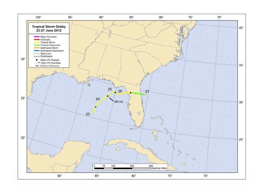
Figure 1. Preliminary unofficial track of Tropical Storm Debby.
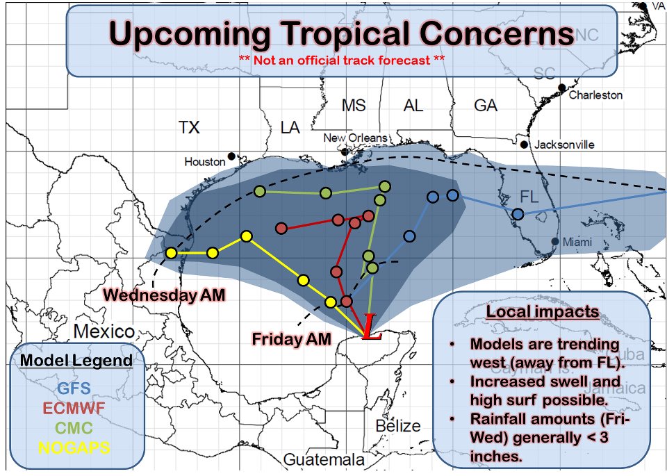
Figure 2. Graphicast issued by this office while the storm was in its formative stages indicating a large spread in model guidance.
Despite the fact that Debby never achieved hurricane strength, the slow movement of the system and prolonged period of onshore flow allowed a moderate storm surge to move into the Florida Big Bend. Figure 3 shows readings from the Apalachicola (top) and Cedar Key (bottom) tide gages during the period when Debby was impacting the forecast area. Maximum surge at Apalachicola was 3.51 feet, while Cedar Key had surge in excess of 4 feet with a total storm tide near 7 feet. Although there is no tide gage in the Apalachee Bay, storm surge was reported to be 4 feet in Wakulla County at St. Marks, FL. These surges resulted in actual inundation of 1.5 feet above ground level in several areas. Several buildings were flooded in Panacea and St. Marks in Wakulla County and in Horseshoe Beach in Dixie County. Many area roads were overwashed with surge water, including U.S. 98 north of St. Marks, Alligator Pt. Road, and Indian Pass Road. Flooding caused other road closures as well and there were many water rescues.
Wind impacts were relatively minor. However, a barge broke loose from its moorings in the St. George Sound and destroyed a portion of the fishing pier, a remnant of the old causeway, on the island side of the sound. The run-away barge forced the closing of the St. George Island Causeway and also the John Gorrie Memorial Bridge, a causeway that extends across the Apalachicola Bay from Eastpoint to Apalachicola, FL. These closures frustrated emergency officials' efforts to evacuate St. George Island. Eventually, resident were lead across the causeway by convoy after tropical storm conditions had already commenced.
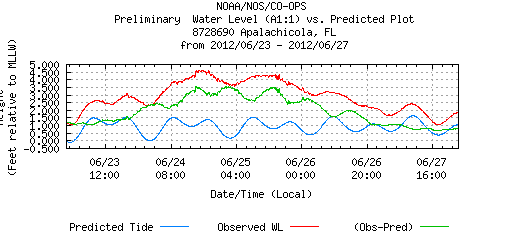
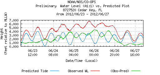
Figure 3. Tide charts for Apalachicola (top) and Cedar Key (bottom) during the time Debby was impacting the forecast area. The red line represents total storm tide in feet. The green line is the surge value above the astronomically-predicted tide (blue line).
The most significant impacts from Debby across the forecast area were related to the torrential rainfall that occurred and the associated flash flooding and river flooding that ensued. Figure 4 shows how a band of very heavy rain set up over southern portions of the Florida Big Bend on Monday, June 25. The persistent downpours prompted the issuance of a Flash Flood Emergency, the first ever issued by this office. Flash flood warning polygons can be seen to the north and northeast of the emergency area. Storm-total rainfall estimated by the KTLH radar is shown in Figure 5. Maximum estimates of greater than 28 inches of rainfall are indicated by the dark blue shading in southwestern Wakulla County. These estimates have been corroborated by reports received from our rain gage network and storm spotters. A cooperative observer located 3 miles southeast of Sanborn, FL, recorded 28.78 inches of rain during the event. Much of the Florida Big Bend from Tallahassee south and east received in excess of a foot of rain (pink shading).
All of this rain resulted in significant inland flooding, especially across Wakulla County. Numerous homes were flooded, some to the 2nd story. A total of 271 structures were impacted to some degree across the county. In addition, two bridges were damaged by flood waters and numerous roads were washed out. Roads were also flooded across portions of Leon, Franklin, Jefferson, Dixie and Lafayette Counties.

Figure 4. A Graphicast issued by this office on Monday, June 25, 2012, showing a band of heavy rain across the southern Florida Big Bend. Flash Flood Emergency and Flash Flood warning polygons are indicated by the arrows.
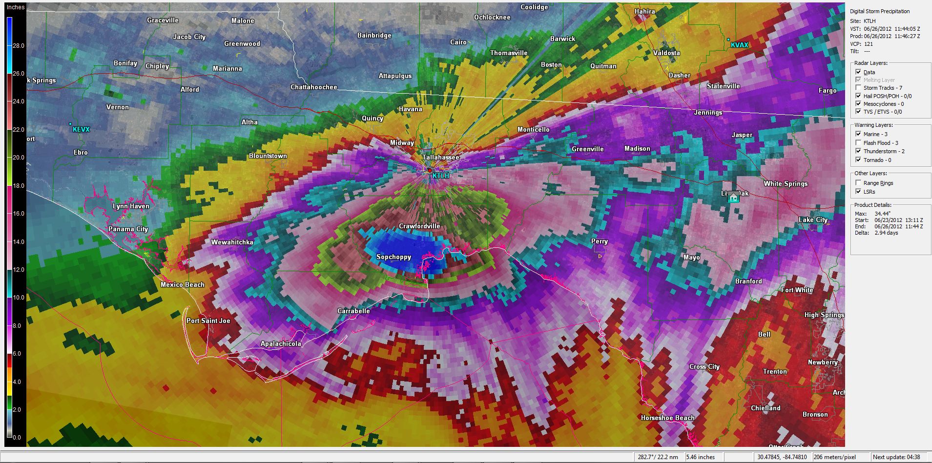
Figure 5. Storm-total rainfall estimates from the KTLH radar for Tropical Storm Debby showing maximum amounts exceeding 28 inches (dark blue) across soutwestern portions of Wakulla County.
This tremendous amount of rainfall over a relatively short period of time resulted in flash flood type flooding on the Sopchoppy River. Figure 6 shows how the river stage at Sopchoppy spiked on the 25th with a record crest of 36.8 feet established the next day. Note the missing data points indicating that the gage itself was overtopped by flood waters. The official crest was later determined by a field survey. Figure 7 shows a "Before & After" picture of flooding in Sopchoppy near Smith Creek Road and Rose Street. The famous Wakulla Springs recorded a record discharge in the aftermath of Debby as indicated in Figure 8. The previous record discharge was 1,910 ft3/s in 1974. Figure 8 indicates that Debby's rainfall resulted in a maximum discharge of approximately 3,300 ft3/s, nearly 10 times the average discharge of 391 ft3/s.

Figure 6. Hydrograph showing the river stage on the Sopchoppy River at Sopchoppy from June 25-30, 2012.
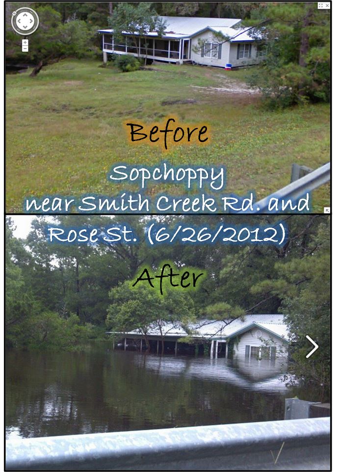
Figure 7. Before and after pictures showing flooding in Sopchoppy, FL, during the record flood on the Sopchoppy River on June 26, 2012, in the aftermath of Tropical Storm Debby.
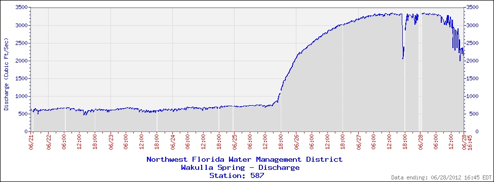
Figure 8. Record discharge, measured in cubic feet per second, from Wakulla Springs in the aftermath of Tropical Storm Debby.

