
Widespread life-threatening flash and urban flooding continues in south-central Texas, with considerable flooding impacts possible across central Texas. Wildfire smoke is impacting air quality across much of the Great Lakes region into southern New England and the Mid-Atlantic. Monsoonal thunderstorms may produce isolated to scattered flash flooding across the Southwest into the Great Basin. Read More >
Overview
|
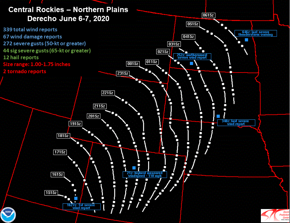
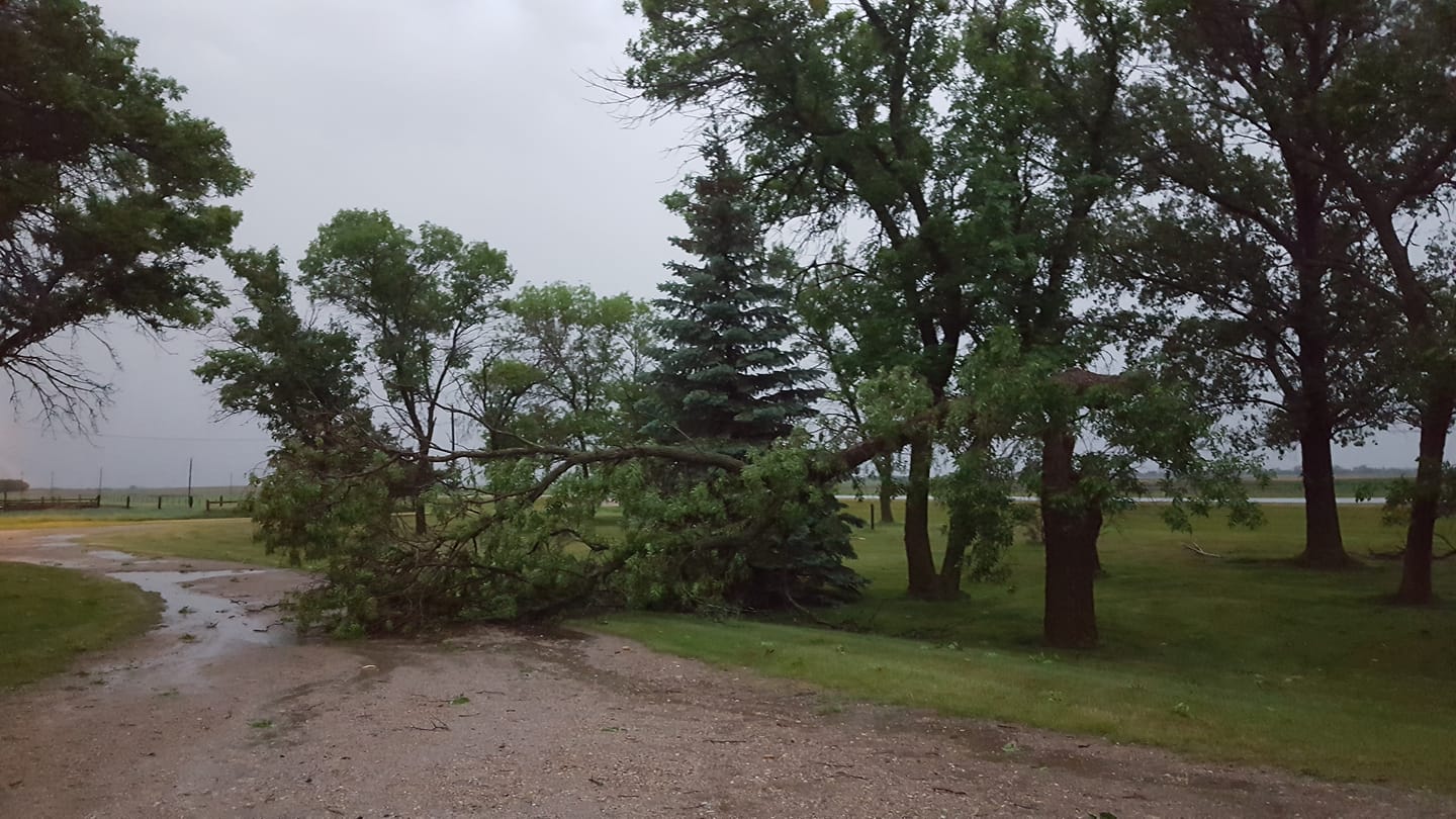
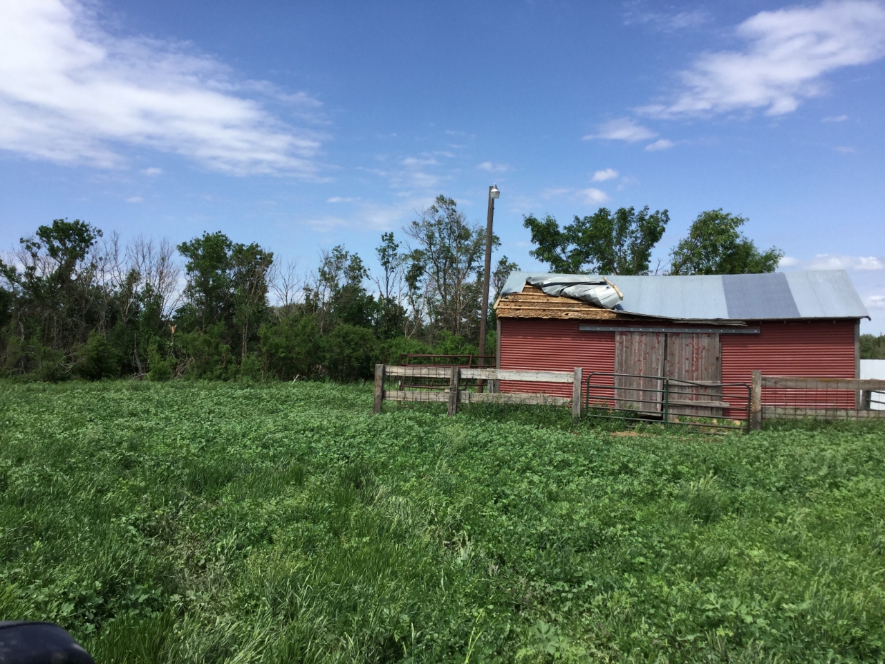
Many severe thunderstorms moved across South Dakota over multiple days in early June 2020, including the 4th, 6th and 7th. The event on the 6th was classified as a derecho (a widespread, long-lived wind storm featuring rapidly moving thunderstorms that last for over 250 miles), that moved northeast out of Colorado and Wyoming and through western and central South Dakota during the evening of June 6th. Winds in western and central South Dakota gusted to 60-80 mph as the derecho moved through. The next wave of storms developed in response to a strong low pressure system over central South Dakota during the late afternoon of June 7th, along and east of a stalled surface boundary from Murdo through Eureka. This led to the severe thunderstorms moving over the same areas multiple times into the early morning hours of June 8th and produced 1-1.75" hail, wind gusts of 60-80+ mph, and three tornadoes. Numerous machine sheds, pole barns, grain bins silos, etc. were damaged or destroyed during these intense storms. |
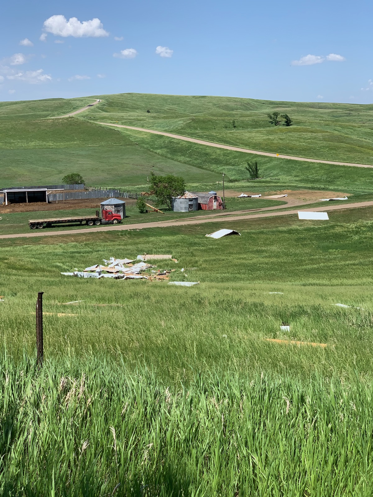
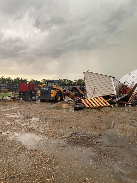
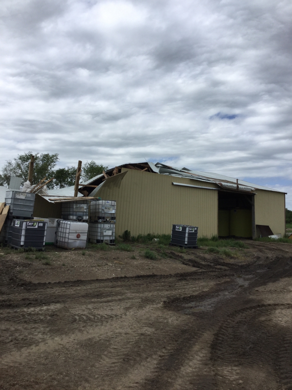
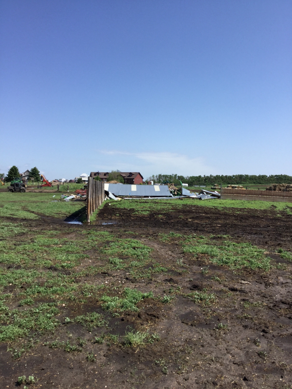
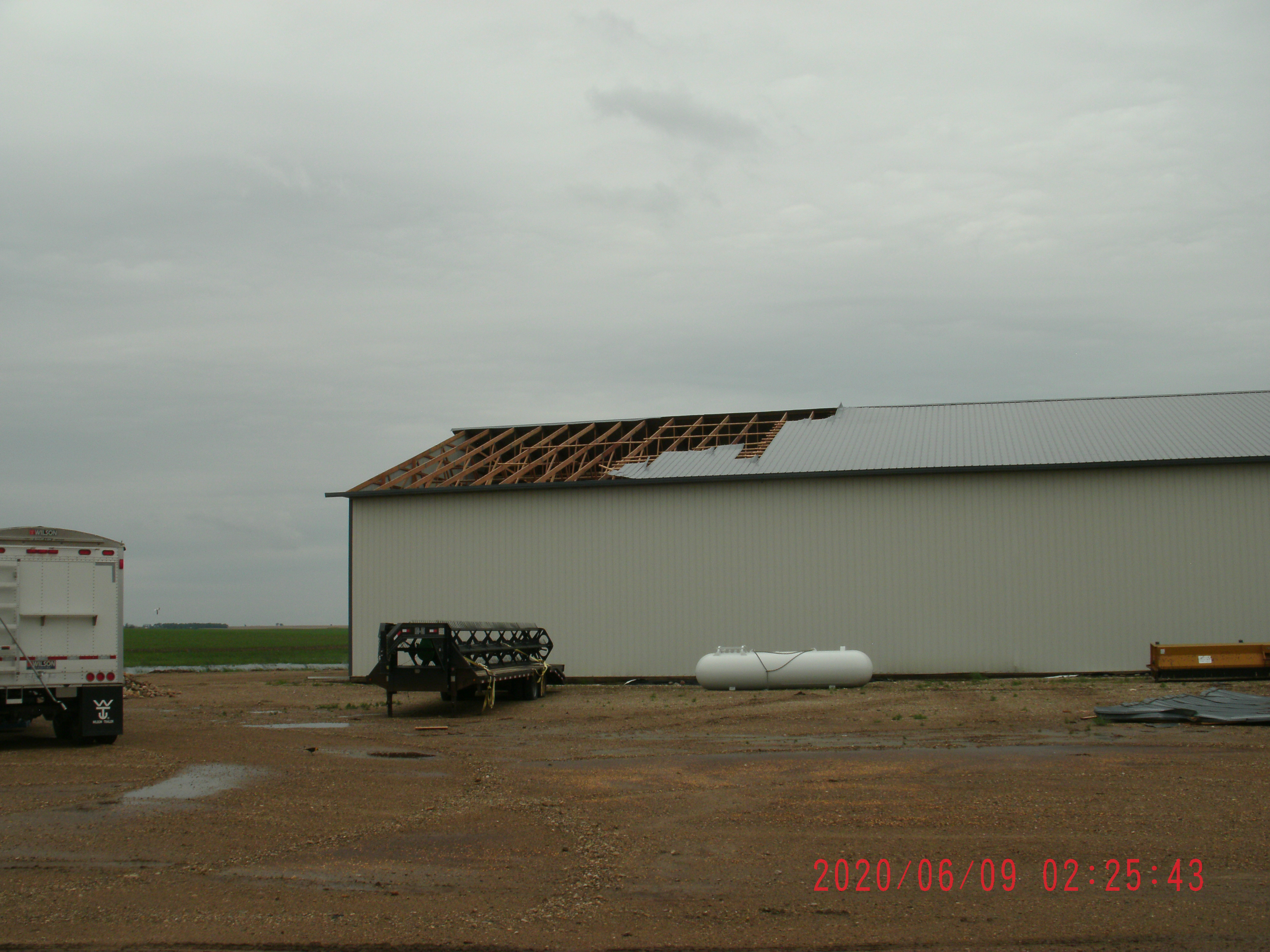 Structural damage from high winds in the Loyalton area on June 7th |
 |
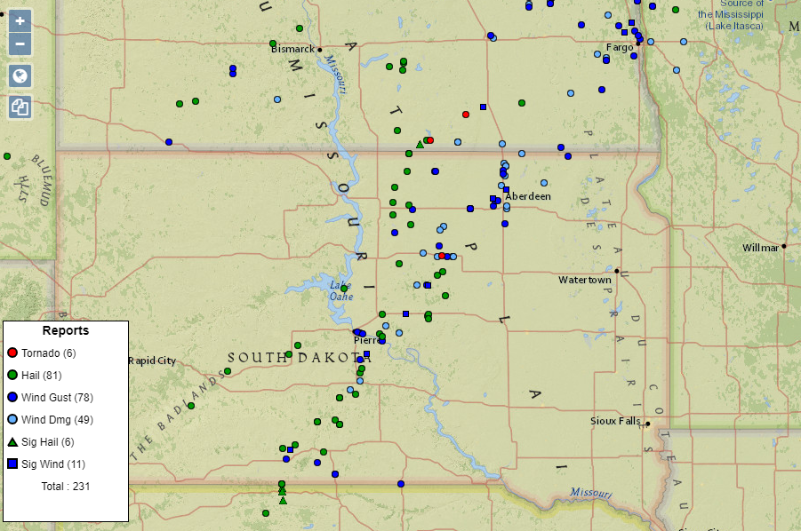 |
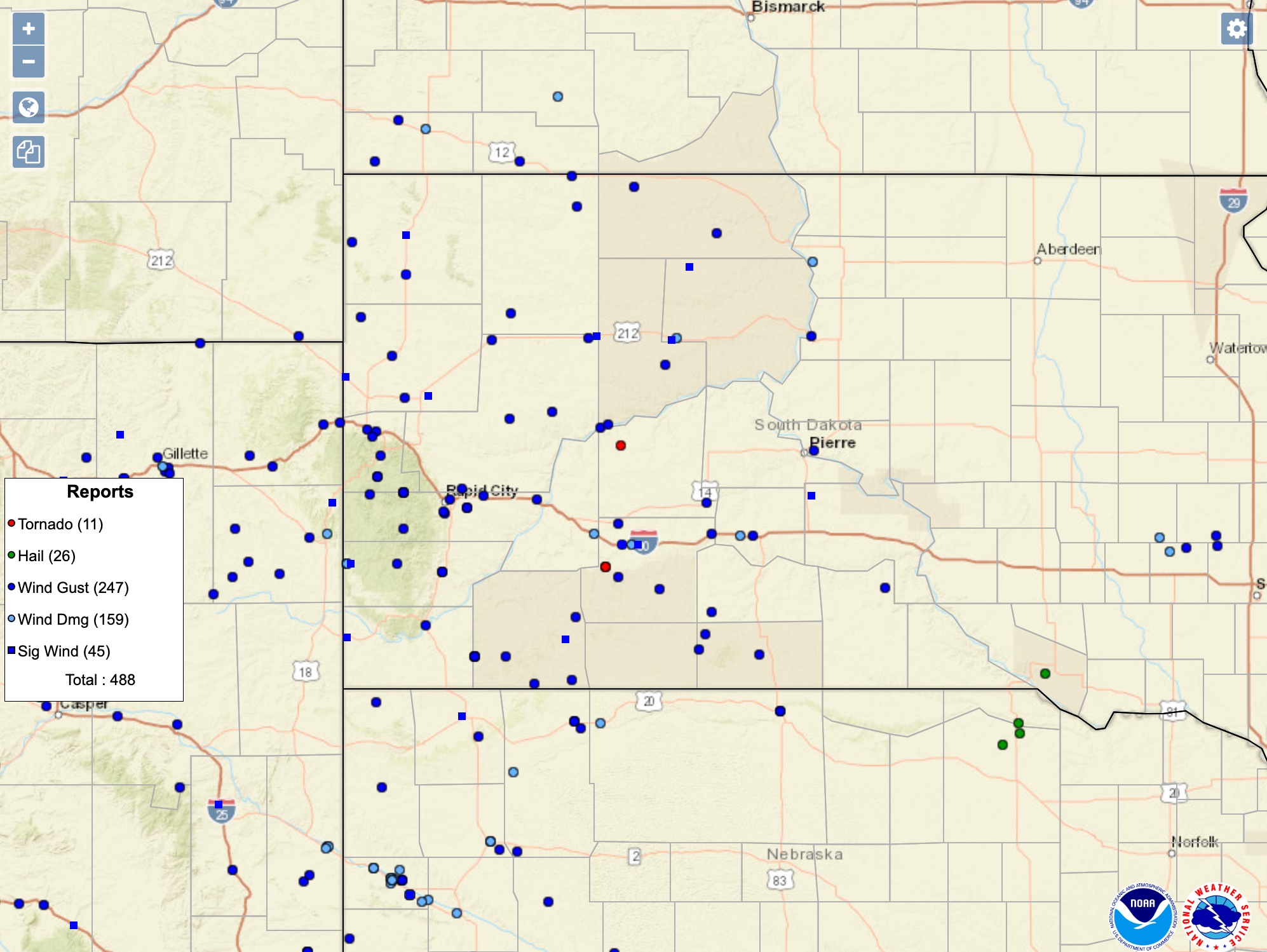
| View of the June 6, 2020 storm reports over western South Dakota (Source) | View of the June 7, 2020 storm reports over South Dakota (Source) |
June 7 Tornadoes:
|
Tornado - 18NW of Highmore
Track Map 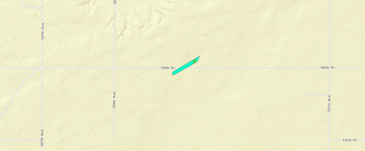 
|
||||||||||||||||
|
Tornado - 18SW Faulkton
Track Map 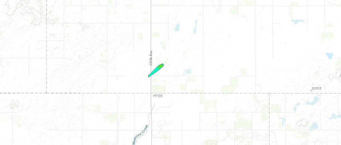
|
||||||||||||||||
|
Tornado - 13W Faulkton
Track Map 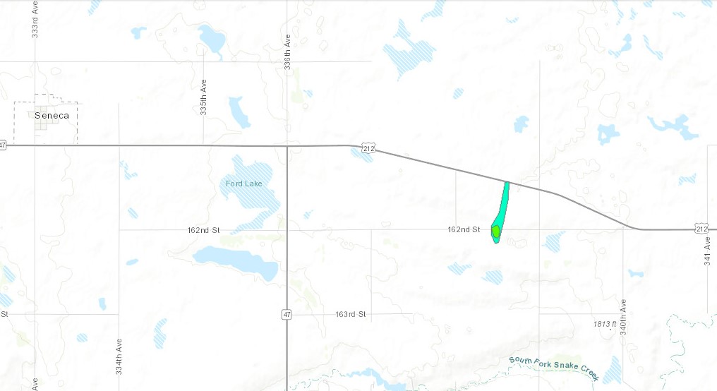
|
||||||||||||||||
|
Tornado - 8WSW Frederick
Track Map 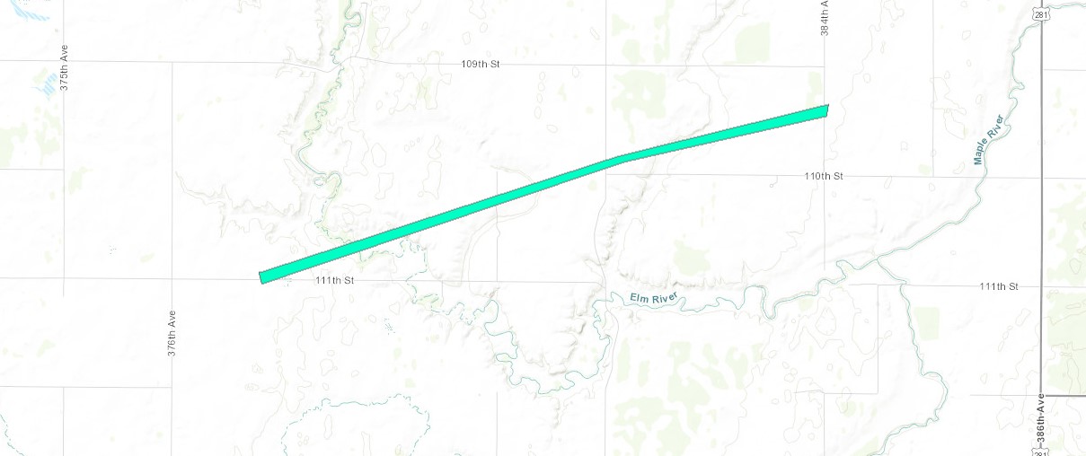
|
||||||||||||||||
The Enhanced Fujita (EF) Scale classifies tornadoes into the following categories:
| EF0 Weak 65-85 mph |
EF1 Moderate 86-110 mph |
EF2 Significant 111-135 mph |
EF3 Severe 136-165 mph |
EF4 Extreme 166-200 mph |
EF5 Catastrophic 200+ mph |
 |
|||||
June 6 - Derecho:
The information below is a brief summary of the derecho event and storm reports in central South Dakota. Additional details on storm reports can be found here.
Derecho Details
 |
 |
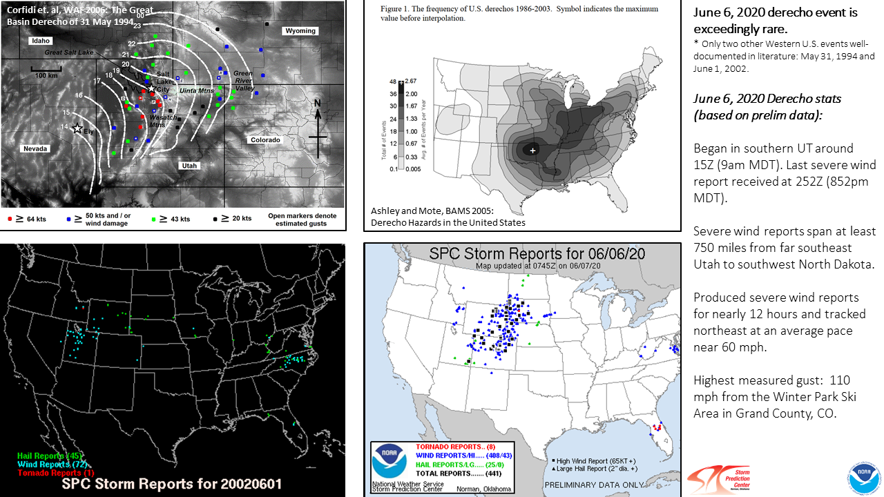 |
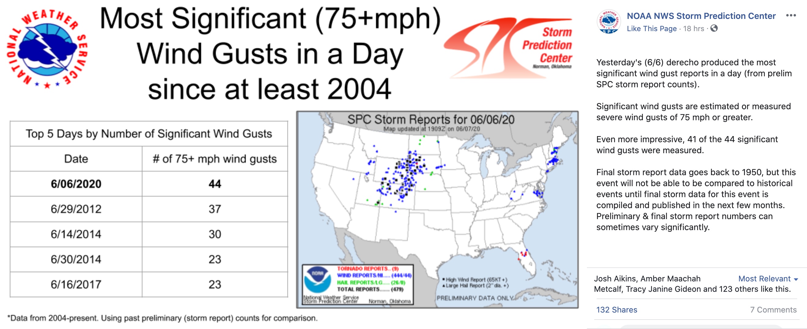
| Map showing the location of the derecho as it moved from Utah to the Dakotas. | SPC: Most Significant (75+ mph) Wind Gusts in a Day since at least 2004 | SPC: Historical perspective on the Derecho that developed in Utah and moved into the Dakotas. |
| Radar loop of the June 6, 2020 derecho travelling from southeast Utah and into the Dakotas | Radar loop over South Dakota from 7PM on June 6th to 1AM on June 7th, 2020. |
Storm Reports
 |
|
 |
 |
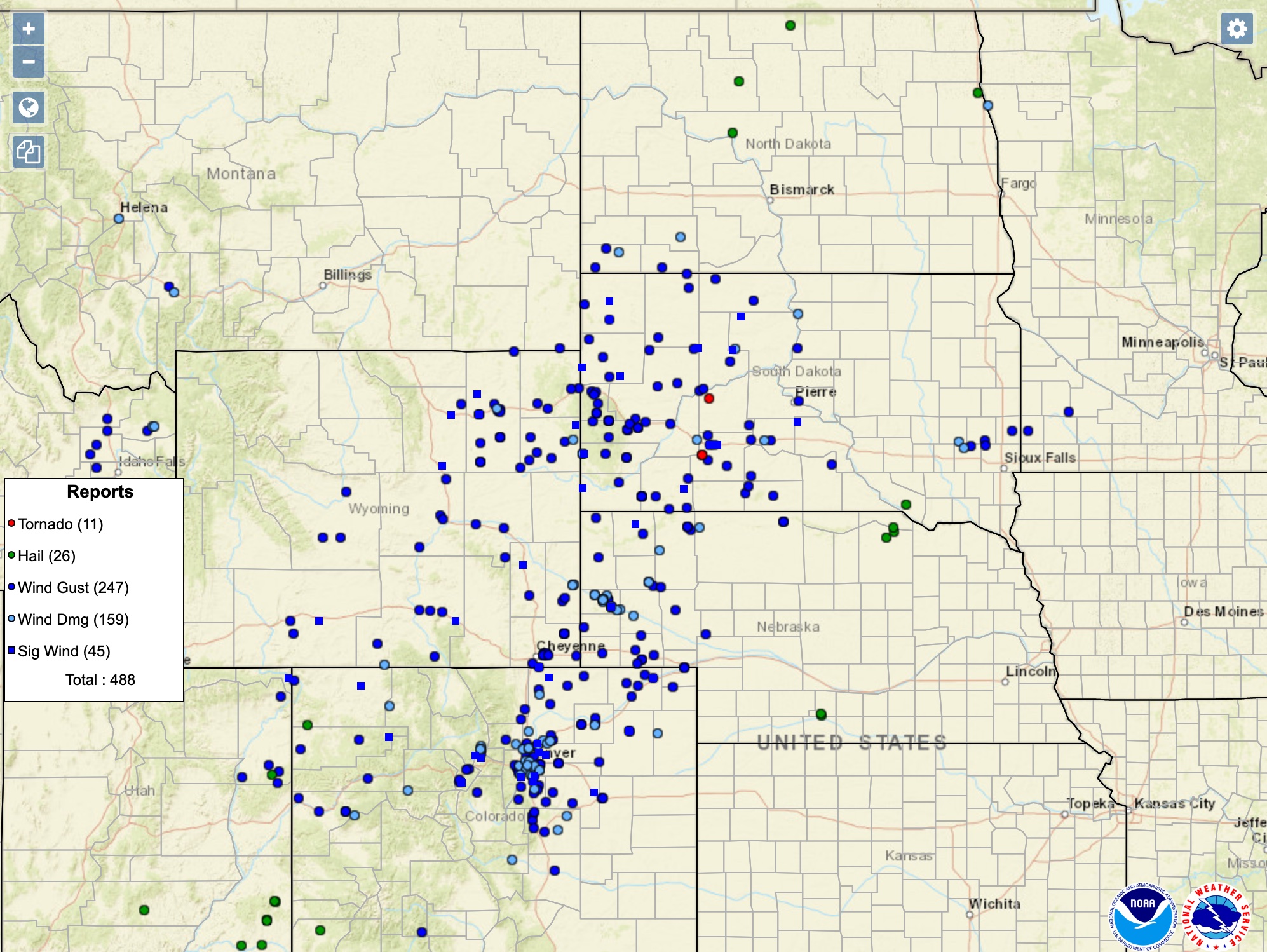
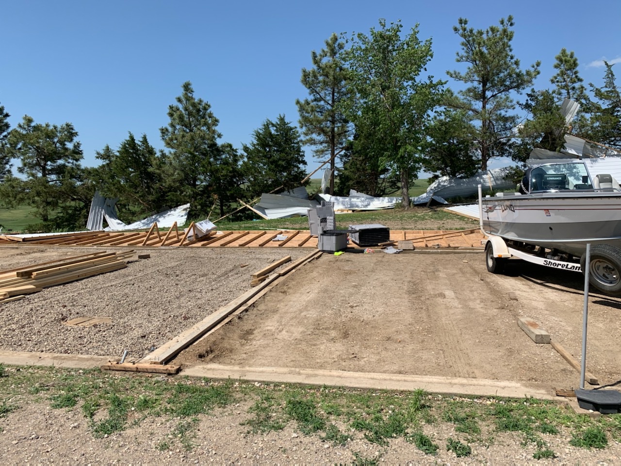
| Regional view of the storm reports from the June 6th event (Source) | View of the storm reports over western South Dakota (Source) | Storage shed destroyed 6 miles south of Glenham (NWS Employee) | Parts of the storage shed were spread down the hill and up to a quarter mile away. (NWS Employee) |
Preliminary Storm Reports
PRELIMINARY LOCAL STORM REPORT
NATIONAL WEATHER SERVICE ABERDEEN SD
207 PM CDT SUN JUN 7 2020

..TIME...   ...EVENT...      ...CITY LOCATION...     ...LAT.LON...
..DATE...   ....MAG....      ..COUNTY LOCATION..ST.. ...SOURCE....
            ..REMARKS..

1130 PM     TSTM WND GST     17 W POLO               44.78N 99.45W
06/06/2020  M52 MPH          HYDE               SD   MESONET

            MESONET STATION 215 JCT SD47/SD26 (SDDOT).

1055 PM     TSTM WND GST     2 S GORMAN              44.90N 100.08W
06/06/2020  M53 MPH          POTTER             SD   MESONET

            MESONET STATION 212 AGAR (SDDOT).

1045 PM     TSTM WND GST     3 SSW WHITLOCKS BAY REC 45.01N 100.29W
06/06/2020  M56 MPH          POTTER             SD   MESONET

1045 PM     TSTM WND DMG     6 S GLENHAM             45.45N 100.29W
06/06/2020                   WALWORTH           SD   NWS EMPLOYEE

            10 UNIT STORAGE SHED DESTROYED. BACK WALL
            PUSHED OVER AND METAL SPREAD DOWNWIND UP TO
            A QUARTER MILE AWAY. BOATS INSIDE WERE NOT
            MOVED. TIME ESTIMATED FROM RADAR.

1037 PM     TSTM WND GST     2 WSW WHITLOCKS BAY REC 45.03N 100.30W
06/06/2020  M70 MPH          DEWEY              SD   STORM CHASER

            GRAVEL BEING LIFTED OFF THE ROAD BY THE
            WIND.

1032 PM     TSTM WND GST     5 S MORRISTOWN          45.87N 101.72W
06/06/2020  E60 MPH          CORSON             SD   PUBLIC

            ESTIMATED 60 MPH WINDS. AN OLIVE TREE WAS
            BLOWN DOWN TOO. TIME ESTIMATED ON RADAR.

1027 PM     TSTM WND GST     2 ENE PIERRE            44.38N 100.28W
06/06/2020  M62 MPH          HUGHES             SD   ASOS

            ASOS STATION KPIR PIERRE MUNI AP.

1020 PM     TSTM WND GST     13 N VIVIAN             44.12N 100.30W
06/06/2020  M76 MPH          LYMAN              SD   MESONET

            MESONET STATION RFPS2 VIVIAN 13 N.

1020 PM     TSTM WND GST     FIRESTEEL               45.42N 101.28W
06/06/2020  E80 MPH          DEWEY              SD   STORM CHASER

            TIME ESTIMATED FROM RADAR.

1015 PM     TSTM WND GST     9 NNW VIVIAN            44.05N 100.33W
06/06/2020  M54 MPH          LYMAN              SD   MESONET


1006 PM     TSTM WND GST     11 S BULLHEAD           45.61N 101.06W
06/06/2020  M59 MPH          CORSON             SD   MESONET

            TIME BETWEEN 907PM AND 1006PM.

1006 PM     TSTM WND GST     10 SW CHANTLER CREEK RE 44.39N 100.77W
06/06/2020  M56 MPH          STANLEY            SD   MESONET

            MESONET STATION 202 HAYES (SDDOT).

1006 PM     TSTM WND GST     4 NW LANTRY             45.06N 101.47W
06/06/2020  M56 MPH          DEWEY              SD   PUBLIC

            TIME ESTIMATED BY RADAR.

0956 PM     TSTM WND DMG     2 E LANTRY              45.02N 101.38W
06/06/2020                   DEWEY              SD   PUBLIC

            REPORT FROM MPING: 1-INCH TREE LIMBS BROKEN;
            SHINGLES BLOWN OFF. TIME ESTIMATED FROM
            RADAR.

0956 PM     TSTM WND GST     LANTRY                  45.01N 101.42W
06/06/2020  M94 MPH          DEWEY              SD   MESONET

            A DAVIS WEATHER STATION MEASURED A GUST OF
            94 MPH. LARGEST TREE BRANCH DOWN WAS ABOUT
            10 INCHES IN DIAMETER.

0948 PM     TSTM WND GST     1 E HAYES               44.37N 101.00W
06/06/2020  M50 MPH          STANLEY            SD   MESONET

0942 PM     TSTM WND GST     3 W MURDO               43.89N 100.77W
06/06/2020  M70 MPH          JONES              SD   STORM CHASER

            18-WHEELER BLOWN OFF I-90 AND INTO THE
            MEDIAN.
June 7 Overview:
Storm Reports
|
 |
 |
|
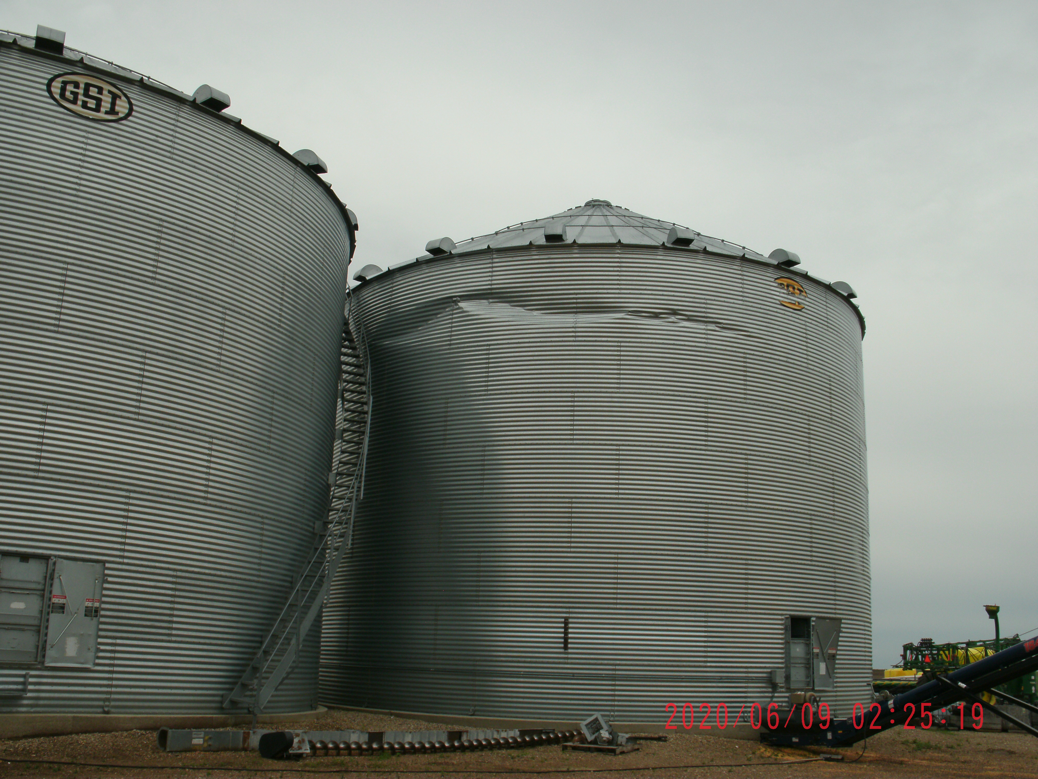
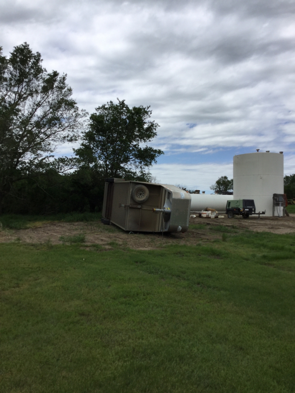
| View of the June 7, 2020 storm reports over South Dakota (Source) | Radar Loop of the severe thunderstorms from 4PM 6/7/2020 to 4AM 6/8/2020. | Tree snapped 2 miles west of Westport, SD (Kristi Burns) | Outbuilding damage near Seneca, SD |
 |
 |
 |
 |
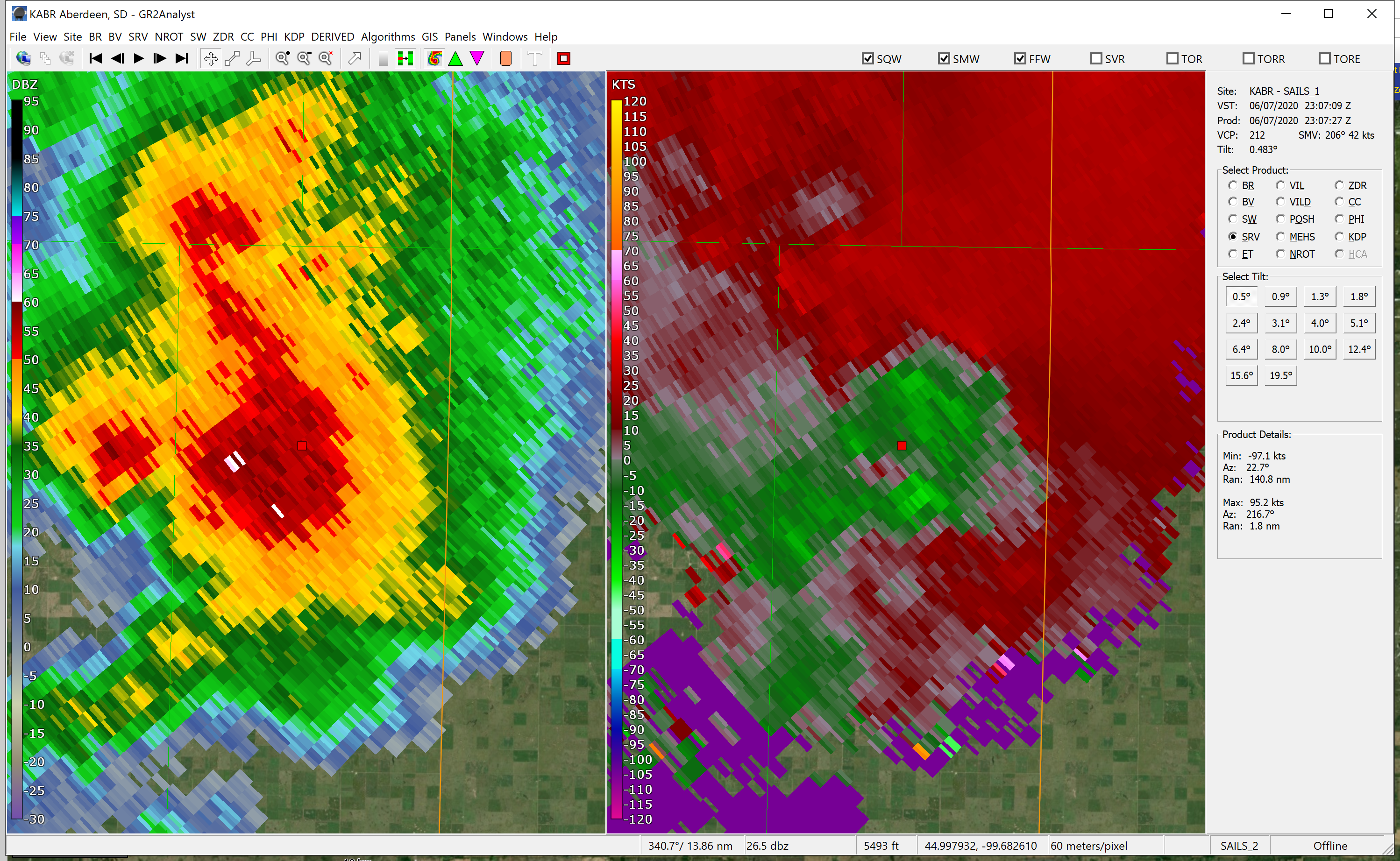
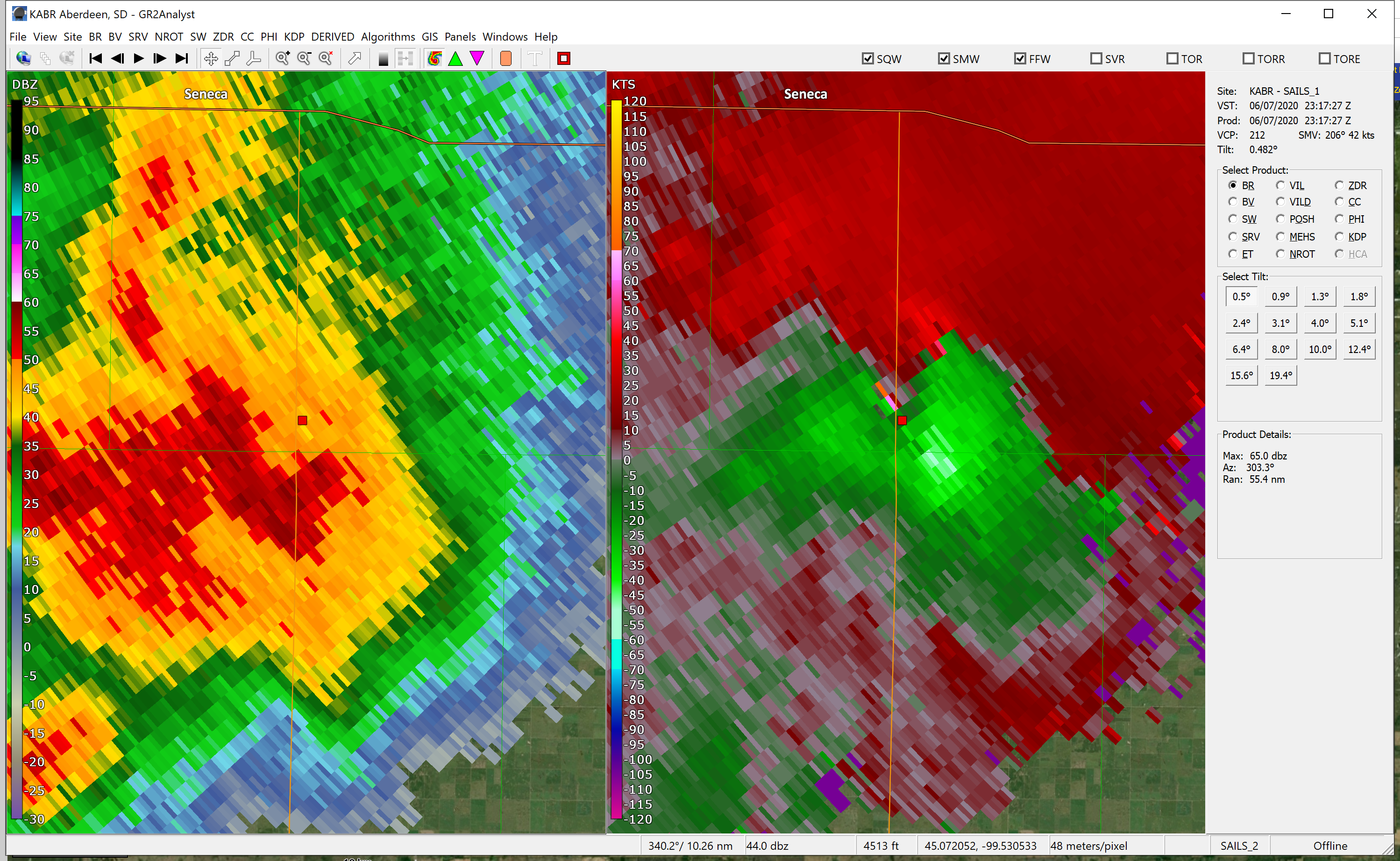
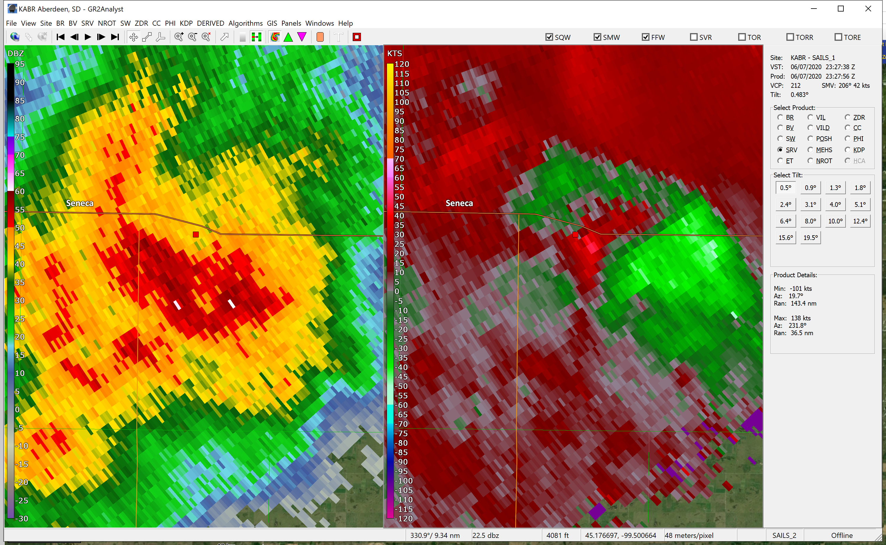
| Radar reflectivity (left) and velocity (right) at 6:07 pm of a tornadic storm 18 miles NW of Highmore | Radar reflectivity (left) and velocity (right) at 6:14 pm of a tornadic storm 18 miles SW of Faulkton | Radar reflectivity (left) and velocity (right) at 6:27 pm of a tornadic storm 13 miles W of Faulkton | Tree uprooted 2 miles west of Westport, SD (Kristi Burns) |
 |
 |
 |
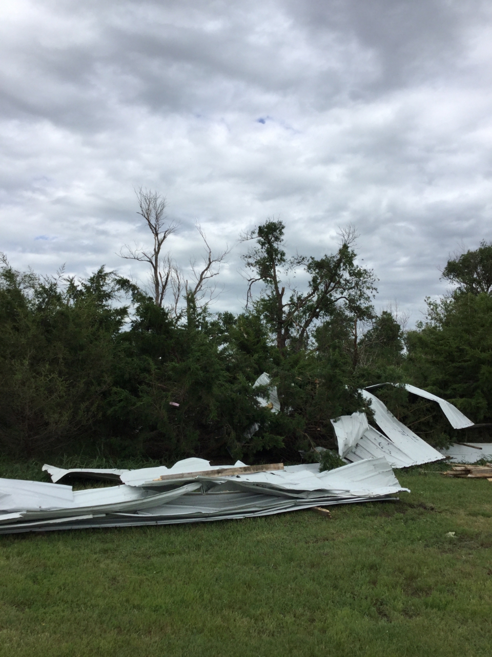 ​ ​ |
| Structural damage from high winds in the Loyalton area | Structural damage from high winds in the Loyalton area | Structural damage from high winds in the Loyalton area | Tornado damage from 18 miles NW of Highmore |
 |
 |
 |
 ​ ​ |
| Tornado damage from 18 miles NW of Highmore | Tornado damage from 18 miles NW of Highmore | Tornado damage from 18 miles NW of Highmore | Tornado damage from 18 miles SW of Faulkton |
 |
 |
 |
 ​ ​ |
| Tornado damage from 18 miles SW of Faulkton | Tornado damage from 18 miles SW of Faulkton | Tornado damage from 13 miles W of Faulkton | Tornado damage from 13 miles W of Faulkton |
 |
 |
​ | |
| Tornado damage from 13 miles W of Faulkton | Tornado damage from 13 miles W of Faulkton |
|
|
| — Michael Charnick (@charnick_wx) June 8, 2020 | — Today's KCCR 1240AM (@todayskccr) June 8, 2020 |
Preliminary Storm Reports
..TIME... ...EVENT... ...CITY LOCATION... ...LAT.LON... ..DATE... ....MAG.... ..COUNTY LOCATION..ST.. ...SOURCE.... ..REMARKS.. 1230 AM Tstm Wnd Gst 4 W Hoven 45.24N 99.86W 06/08/2020 M65 MPH Potter SD Public 0710 PM Tstm Wnd Gst 13 E Eureka 45.77N 99.35W 06/07/2020 M63 MPH McPherson SD Mesonet 0709 PM Tstm Wnd Gst 10 SW Long Lake 45.77N 99.36W 06/07/2020 M63 MPH McPherson SD Mesonet Mesonet station 184 Eureka (SDDOT). 0945 PM Tstm Wnd Gst 1 NNW Kidder 45.90N 97.72W 06/07/2020 E60 MPH Marshall SD Public 50-60 mph gust. 0915 PM Tstm Wnd Gst 5 NW Kidder 45.93N 97.79W 06/07/2020 M52 MPH Marshall SD Mesonet Personal weather station. 0626 PM Tstm Wnd Gst 12 SW Rosseau 44.17N 100.21W 06/07/2020 E75 MPH Lyman SD Public 0612 PM Tstm Wnd Gst 13 N Vivian 44.12N 100.29W 06/07/2020 M67 MPH Lyman SD Mesonet 0734 PM Tstm Wnd Gst 17 W Polo 44.78N 99.45W 06/07/2020 M76 MPH Hyde SD Mesonet Corrects previous non-tstm wnd gst report from 17 W Polo. Mesonet station 215 JCT SD47/SD26 (SDDOT). 0619 PM Tstm Wnd Gst 17 W Polo 44.78N 99.46W 06/07/2020 M69 MPH Hyde SD Mesonet 1137 PM Tstm Wnd Gst 4 ESE Pierre 44.35N 100.25W 06/07/2020 E60 MPH Hughes SD Public Lots of pea sized hail. 0730 PM Tstm Wnd Gst 4 ESE Rosseau 44.29N 100.01W 06/07/2020 M60 MPH Hughes SD Mesonet 0709 PM Tstm Wnd Gst 1 ENE Harrold 44.53N 99.72W 06/07/2020 M78 MPH Hughes SD Mesonet Mesonet station 19 Harrold (SDDOT). 0624 PM Tstm Wnd Gst Pierre 44.37N 100.32W 06/07/2020 M64 MPH Hughes SD ASOS 0609 PM Tstm Wnd Gst 2 ESE Pierre 44.36N 100.29W 06/07/2020 M63 MPH Hughes SD Mesonet 0520 PM Tstm Wnd Gst 4 ESE Rosseau 44.29N 100.01W 06/07/2020 M53 MPH Hughes SD Mesonet 0939 PM Tstm Wnd Gst 4 W Faulkton 45.03N 99.21W 06/07/2020 M54 MPH Faulk SD Mesonet Personal weather station. 0634 PM Tstm Wnd Gst 4 W Faulkton 45.03N 99.21W 06/07/2020 M63 MPH Faulk SD Mesonet Report from personal weather station. 0634 PM Tstm Wnd Gst Brentwood Colony 45.12N 99.31W 06/07/2020 M67 MPH Faulk SD Mesonet 1025 PM Tstm Wnd Gst Cravens Corner 45.45N 98.93W 06/07/2020 M55 MPH Edmunds SD Mesonet 1005 PM Tstm Wnd Gst Cravens Corner 45.45N 98.93W 06/07/2020 E72 MPH Edmunds SD Mesonet Report of 72 mph wind at 10:05 pm, 72 at 10:10 pm, and 53 mph at 10:15 pm. 0815 PM Tstm Wnd Gst Cravens Corner 45.45N 98.93W 06/07/2020 M67 MPH Edmunds SD Mesonet 0810 PM Tstm Wnd Gst Cravens Corner 45.45N 98.93W 06/07/2020 M62 MPH Edmunds SD Storm Chaser 0734 PM Tstm Wnd Gst 1 ESE Bowdle 45.44N 99.64W 06/07/2020 M66 MPH Edmunds SD Mesonet Mesonet station 216 Bowdle (SDDOT). 0704 PM Tstm Wnd Gst Cravens Corner 45.45N 98.93W 06/07/2020 M62 MPH Edmunds SD Mesonet Mesonet station 173 Craven (SDDOT). 0915 PM Tstm Wnd Gst Warner 45.32N 98.50W 06/07/2020 M70 MPH Brown SD Emergency Mngr 60 to 70 mph winds. 0843 PM Tstm Wnd Gst 6 N Frederick 45.92N 98.53W 06/07/2020 M50 MPH Brown SD Storm Chaser Strong outflow winds coming from the southwest. Less than 1/8 mile visibility. 0840 PM Tstm Wnd Gst 2 SE Richmond Lake Rec 45.52N 98.58W 06/07/2020 M70 MPH Brown SD Mesonet 0836 PM Tstm Wnd Gst 2 NW Barnard 45.75N 98.52W 06/07/2020 M61 MPH Brown SD Storm Chaser 0834 PM Tstm Wnd Gst 3 S Frederick 45.78N 98.52W 06/07/2020 M66 MPH Brown SD Storm Chaser 60 mph sustained winds from the west for a few minutes. 0830 PM Tstm Wnd Gst 2 SSW Richmond Lake Rec 45.52N 98.62W 06/07/2020 M66 MPH Brown SD Public 1 inch of rain as of 10:15pm. 0830 PM Tstm Wnd Gst 3 SSE Westport 45.61N 98.48W 06/07/2020 E80 MPH Brown SD Emergency Mngr 0825 PM Tstm Wnd Gst 1 W Richmond Lake Rec A 45.54N 98.64W 06/07/2020 M79 MPH Brown SD NWS Employee 0820 PM Tstm Wnd Gst 5 SSW Richmond Lake Rec 45.47N 98.64W 06/07/2020 M68 MPH Brown SD Mesonet 0738 PM Tstm Wnd Dmg Vivian 43.93N 100.29W 06/07/2020 Lyman SD Emergency Mngr Roof torn off a building. Time estimated by radar. 0730 PM Tstm Wnd Dmg 8 SW Vivian 43.85N 100.41W 06/07/2020 Jones SD Storm Chaser Large tree down over road. Residence in this area are without electricity. 0730 PM Tstm Wnd Dmg 5 ESE Draper 43.91N 100.44W 06/07/2020 Jones SD Storm Chaser 0600 PM Tstm Wnd Dmg 18 N Holabird 44.78N 99.59W 06/07/2020 Hyde SD Trained Spotter Roof off 60x100 foot machine shed, wall in on barn. Radar estimated time. 0815 PM Tstm Wnd Dmg 12 ESE Canning 44.36N 99.80W 06/07/2020 Hughes SD CO-OP Observer Electrical pole down. 1 inch hail. Several broken tree limbs. 0653 PM Tstm Wnd Dmg 4 ENE Canning 44.42N 99.97W 06/07/2020 Hughes SD Public Partial roof off barn, 2 calves killed, overhead door on another outbuilding blown in. Time estimated from radar. 0631 PM Tstm Wnd Dmg Faulkton 45.03N 99.13W 06/07/2020 Faulk SD Public Power poles down. 3 inch tree limbs down. 0630 PM Tstm Wnd Dmg 1 W Faulkton 45.03N 99.15W 06/07/2020 Faulk SD Law Enforcement 1 tree down. Time estimated by radar. 0626 PM Tstm Wnd Dmg Seneca 45.06N 99.51W 06/07/2020 Faulk SD Public Several buildings damaged. 0620 PM Tstm Wnd Dmg 1 SW Burkmere 45.03N 99.33W 06/07/2020 Faulk SD Law Enforcement Several buildings damaged. Time estimated by radar. 0750 PM Tstm Wnd Dmg 2 SSW Loyalton 45.26N 99.30W 06/07/2020 Edmunds SD Emergency Mngr 5 outbuildings damaged. Approximate timing. 0750 PM Tstm Wnd Dmg 1 E Loyalton 45.29N 99.26W 06/07/2020 Edmunds SD Emergency Mngr Garage and outbuildings with damage including a roof off. Approximate time. 0920 PM Tstm Wnd Dmg 1 E Aberdeen 45.47N 98.47W 06/07/2020 Brown SD Public Report from mPING: 1-inch tree limbs broken; Shingles blown off. 0918 PM Tstm Wnd Dmg 1 S Aberdeen 45.45N 98.48W 06/07/2020 Brown SD NWS Employee A couple tree limbs down. Approximate timing. 0855 PM Tstm Wnd Dmg Claremont 45.67N 98.01W 06/07/2020 Brown SD Public Large trees down. Time estimated by radar. 0840 PM Tstm Wnd Dmg Barnard 45.73N 98.50W 06/07/2020 Brown SD Public Several trees down and fences blown over in town. 0840 PM Tstm Wnd Dmg 1 SE Frederick 45.82N 98.49W 06/07/2020 Brown SD Public irrigation pivot flipped over. 0840 PM Tstm Wnd Dmg 7 WNW Hecla 45.92N 98.29W 06/07/2020 Brown SD Cocorahs Some tree damage reported via Cocorahs comments section. Radar estimated time. 0839 PM Tstm Wnd Dmg 1 SE Frederick 45.82N 98.49W 06/07/2020 Brown SD Public Large tree branches down. Soft topped out building damaged. 0839 PM Tstm Wnd Dmg Frederick 45.84N 98.51W 06/07/2020 Brown SD Public Large tree fell into the roof of an apartment building. Building sustained water damage. 0835 PM Tstm Wnd Dmg 2 W Westport 45.65N 98.54W 06/07/2020 Brown SD Public Several large trees down. At least one uprooted. 0745 PM Tornado 2 ESE Burkmere 45.04N 99.28W 06/07/2020 Faulk SD Storm Chaser Location estimated based on storm chaser report and radar. 0624 PM Hail 7 NE Lowry 45.39N 99.88W 06/07/2020 M1.00 inch Walworth SD Trained Spotter 0615 PM Hail Java 45.50N 99.88W 06/07/2020 M1.75 inch Walworth SD Public 0832 PM Hail 10 N Okobojo Creek Rec 44.75N 100.49W 06/07/2020 M1.00 inch Sully SD Trained Spotter 0823 PM Hail 2 ENE Bunker 44.25N 101.06W 06/07/2020 M1.50 inch Stanley SD Emergency Mngr 0550 PM Hail 7 SSW Lebanon 44.97N 99.80W 06/07/2020 E1.25 inch Potter SD Public Radar estimated time. 0639 PM Hail Eureka 45.77N 99.63W 06/07/2020 U0.75 inch McPherson SD Public Report from mPING: Dime (0.75 in.). 0637 PM Hail 4 NW Hillsview 45.70N 99.62W 06/07/2020 M0.70 inch McPherson SD Fire Dept/Rescue 0619 PM Hail 2 ENE Greenway 45.92N 99.68W 06/07/2020 E1.00 inch McPherson SD Public Nickle to quarter hail. 0559 PM Hail 2 ENE Greenway 45.92N 99.68W 06/07/2020 E1.50 inch McPherson SD Public Two rounds of hail, this was the first. 0546 PM Hail 4 W Eureka 45.77N 99.71W 06/07/2020 M1.00 inch McPherson SD Storm Chaser 0750 PM Hail 8 N Vivian 44.04N 100.27W 06/07/2020 M1.00 inch Lyman SD Public 0740 PM Hail 5 N Vivian 44.00N 100.29W 06/07/2020 M1.50 inch Lyman SD Public 1004 PM Hail 9 SSW Vivian 43.81N 100.34W 06/07/2020 E1.00 inch Jones SD Public Strong winds too. Radar estimated time. 0613 PM Hail 7 ENE Westover 43.78N 100.54W 06/07/2020 E1.00 inch Jones SD Public Corrects previous hail report from 7 ENE Westover, based off radar data. 1023 PM Hail 12 W Orient 44.87N 99.33W 06/07/2020 E1.75 inch Hyde SD Trained Spotter 0840 PM Hail 3 S Highmore 44.48N 99.44W 06/07/2020 M1.75 inch Hyde SD Public 0840 PM Hail Highmore 44.52N 99.44W 06/07/2020 M1.50 inch Hyde SD Public 0840 PM Hail 1 SW Highmore 44.51N 99.45W 06/07/2020 M1.50 inch Hyde SD Public 0835 PM Hail 3 ENE Rosseau 44.33N 100.01W 06/07/2020 E1.25 inch Hughes SD Trained Spotter Exact location and time estimated from radar. 0516 PM Hail 1 W Blunt 44.52N 100.01W 06/07/2020 M1.50 inch Hughes SD Emergency Mngr 0500 PM Hail 3 NNE Rosseau 44.35N 100.05W 06/07/2020 E1.25 inch Hughes SD Public 0859 PM Hail 9 SW Polo 44.69N 99.23W 06/07/2020 E1.25 inch Hand SD Public Radar estimated time. 1035 PM Hail Faulkton 45.03N 99.13W 06/07/2020 M0.70 inch Faulk SD Public 0827 PM Hail 9 W Orient 44.90N 99.27W 06/07/2020 E1.75 inch Faulk SD Public Radar estimated time. 0750 PM Hail 2 NW Bowdle 45.48N 99.68W 06/07/2020 E1.50 inch Edmunds SD Public Time estimated by radar. 0707 PM Hail 7 NNW Tolstoy 45.31N 99.66W 06/07/2020 M1.00 inch Edmunds SD Emergency Mngr 0625 PM Hail 6 NNW Tolstoy 45.29N 99.66W 06/07/2020 M0.70 inch Edmunds SD Emergency Mngr 0642 PM Hail 9 N Java 45.63N 99.86W 06/07/2020 E1.75 inch Campbell SD Public Nickle to golf ball sized hail briefly, very heavy rain. 0920 PM Hail 3 SW Aberdeen 45.44N 98.53W 06/07/2020 M0.70 inch Brown SD Storm Chaser
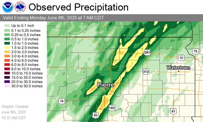
Precipitation Reports
24 hours ending at 7 AM on June 8, 2020
PRELIMINARY LOCAL STORM REPORT
NATIONAL WEATHER SERVICE ABERDEEN SD
1034 AM CDT MON JUN 8 2020

..TIME...   ...EVENT...      ...CITY LOCATION...     ...LAT.LON...
..DATE...   ....MAG....      ..COUNTY LOCATION..ST.. ...SOURCE....
            ..REMARKS..

0600 AM     HEAVY RAIN       18 N HOLABIRD           44.78N 99.57W
06/08/2020  M3.26 INCH       HYDE               SD   COCORAHS

            COCORAHS STATION SD-HY-2 HIGHMORE 19 NNW.

0800 AM     HEAVY RAIN       5 N HARROLD             44.60N 99.73W
06/08/2020  M2.76 INCH       SULLY              SD   COCORAHS

            COCORAHS STATION SD-SL-19 HARROLD 5 N.

0700 AM     HEAVY RAIN       16 S SENECA             44.83N 99.48W
06/08/2020  M2.65 INCH       HYDE               SD   COCORAHS

            COCORAHS STATION SD-HY-6 SENECA 16 S.

0800 PM     HEAVY RAIN       IPSWICH                 45.45N 99.03W
06/07/2020  M2.57 INCH       EDMUNDS            SD   CO-OP OBSERVER

            CO-OP OBSERVER STATION IPSS2 IPSWICH.

0700 AM     HEAVY RAIN       6 W BARNARD             45.74N 98.62W
06/08/2020  M2.53 INCH       BROWN              SD   COCORAHS

            COCORAHS STATION SD-BR-37 FREDERICK 8 SW.

0700 AM     HEAVY RAIN       6 NE LOYALTON           45.35N 99.19W
06/08/2020  M2.17 INCH       EDMUNDS            SD   COCORAHS

            COCORAHS STATION SD-ED-12 LOYALTON 5 NE.

0700 AM     HEAVY RAIN       9 N HOLABIRD            44.65N 99.60W
06/08/2020  M2.07 INCH       HYDE               SD   COCORAHS

            COCORAHS STATION SD-HY-8 HOLABIRD 8.5 N.

0500 AM     HEAVY RAIN       3 NW WESTPORT           45.68N 98.53W
06/08/2020  M2.00 INCH       BROWN              SD   CO-OP OBSERVER

            CO-OP OBSERVER STATION WPTS2 WESTPORT 2 NW.

0959 AM     HEAVY RAIN       13 N VIVIAN             44.12N 100.30W
06/08/2020  M1.95 INCH       LYMAN              SD   CO-OP OBSERVER

            CO-OP OBSERVER STATION RFPS2 13.0 N VIVIAN.

0800 AM     HEAVY RAIN       5 N VIVIAN              44.00N 100.29W
06/08/2020  M1.90 INCH       LYMAN              SD   COCORAHS

            COCORAHS STATION SD-LY-32 VIVIAN 4 N.

0600 AM     HEAVY RAIN       2 NE MINA               45.46N 98.73W
06/08/2020  M1.86 INCH       EDMUNDS            SD   COCORAHS

            COCORAHS STATION SD-ED-14 MINA 2 NE.

0700 AM     HEAVY RAIN       3 S GORMAN              44.89N 100.08W
06/08/2020  M1.83 INCH       SULLY              SD   COCORAHS

            COCORAHS STATION SD-SL-20 GORMAN 2 SSW.

0700 AM     HEAVY RAIN       8 N VIVIAN              44.04N 100.27W
06/08/2020  M1.79 INCH       LYMAN              SD   COCORAHS

            COCORAHS STATION SD-LY-5 VIVIAN 7 NNE.

0800 AM     HEAVY RAIN       7 WNW HECLA             45.92N 98.29W
06/08/2020  M1.76 INCH       BROWN              SD   COCORAHS

            COCORAHS STATION SD-BR-4 HECLA 7 WNW.

0700 AM     HEAVY RAIN       6 W ROSCOE              45.45N 99.46W
06/08/2020  M1.73 INCH       EDMUNDS            SD   COCORAHS

            COCORAHS STATION SD-ED-6 ROSCOE 6 W.

0800 AM     HEAVY RAIN       4 N BOWDLE              45.51N 99.65W
06/08/2020  M1.70 INCH       EDMUNDS            SD   COCORAHS

            COCORAHS STATION SD-ED-13 BOWDLE 3.8 N.

0800 AM     HEAVY RAIN       5 SE SUTTON BAY REC ARE 44.84N 100.27W
06/08/2020  M1.66 INCH       SULLY              SD   COCORAHS

            COCORAHS STATION SD-SL-8 AGAR 10 W.

0700 AM     HEAVY RAIN       GETTYSBURG              45.01N 99.95W
06/08/2020  M1.65 INCH       POTTER             SD   COCORAHS

            COCORAHS STATION SD-PT-7 GETTYSBURG 0.3 NE.

0916 AM     HEAVY RAIN       5 WSW HOUGHTON          45.73N 98.30W
06/08/2020  M1.62 INCH       BROWN              SD   CO-OP OBSERVER

            CO-OP OBSERVER STATION CBAS2 HOUGHTON 5 W.

0600 AM     HEAVY RAIN       7 E HAYES               44.37N 100.89W
06/08/2020  M1.55 INCH       STANLEY            SD   CO-OP OBSERVER

            CO-OP OBSERVER STATION AYES2 HAYES 6 E.

0800 AM     HEAVY RAIN       17 N HIGHMORE           44.77N 99.47W
06/08/2020  M1.54 INCH       HYDE               SD   COCORAHS

            COCORAHS STATION SD-HY-10 HIGHMORE 17 N.

0900 AM     HEAVY RAIN       2 WNW RICHMOND LAKE REC 45.55N 98.64W
06/08/2020  M1.48 INCH       BROWN              SD   COCORAHS

            COCORAHS STATION SD-BR-16 ABERDEEN 9 NW.

0800 AM     HEAVY RAIN       FAULKTON                45.03N 99.13W
06/08/2020  M1.45 INCH       FAULK              SD   CO-OP OBSERVER

            CO-OP OBSERVER STATION FAUS2 FAULKTON 1 NW.

0800 AM     HEAVY RAIN       1 NNW EUREKA            45.78N 99.63W
06/08/2020  M1.44 INCH       MCPHERSON          SD   CO-OP OBSERVER

            CO-OP OBSERVER STATION ERKS2 EUREKA.

0800 AM     HEAVY RAIN       EUREKA                  45.77N 99.62W
06/08/2020  M1.44 INCH       MCPHERSON          SD   COCORAHS

            COCORAHS STATION SD-MP-3 EUREKA.

0700 AM     HEAVY RAIN       11 E ONIDA              44.67N 99.84W
06/08/2020  M1.44 INCH       SULLY              SD   COCORAHS

            COCORAHS STATION SD-SL-27 HARROLD 11.5 NNW.

0900 AM     HEAVY RAIN       2 N HOVEN               45.28N 99.77W
06/08/2020  M1.43 INCH       WALWORTH           SD   COCORAHS

            COCORAHS STATION SD-WL-2 HOVEN 2 N.
 |
Media use of NWS Web News Stories is encouraged! Please acknowledge the NWS as the source of any news information accessed from this site. |
|

