Scattered strong to severe thunderstorms may pose a risk for damaging wind gusts over the Carolinas, southeast Virginia, and the Tennessee Valley Sunday afternoon then the northern Plains from late afternoon into Sunday night. Monsoonal thunderstorms may cause locally considerable flash, urban, and small stream flooding in the Southwest U.S. the next few days. Read More >
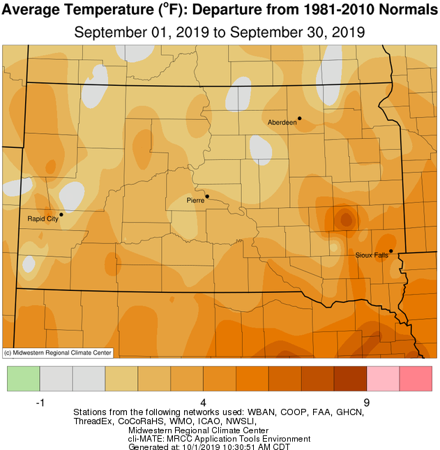
September 2019 featured above normal temperatures on a whole across the area, thanks in large part to much above normal low temperatures. Daily record warm low temperatures in the mid-60s to low 70s were recorded at 16th and/or 17th at Aberdeen, Watertown, Pierre and/or Mobridge. While the average first 32 degree temperature occurs during the final third of September on average across the area (early October for south central South Dakota), the majority of us avoided it this September. The exception for a few occurred on the morning of the 28th, when frost was observed across portions of northeastern South Dakota and west central Minnesota in response to generally mid-30 degree temperatures.
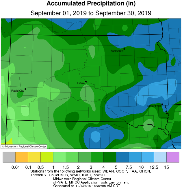
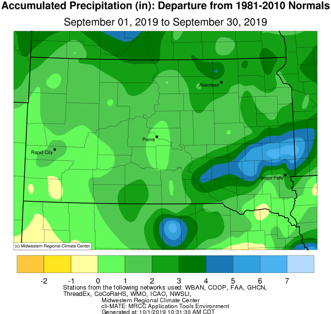
September 2019 was wetter than average across the board, with portions of northeastern and east central South Dakota having recorded the greatest departures from normal (2+ inches). Daily rainfall records were set at Aberdeen, Pierre, Sisseton and Mobridge on the 9th, 11th, and/or 12th. Several locations recorded top-10 wettest Septembers on record: 8th in Pierre, 6th in Mobridge, 5th in Aberdeen, 4th in Timber Lake, 4th in Wheaton, and 2nd in Sisseton (6.65” in 2004). In what was just another wet month in an incredibly wet year, here are some updates for rankings of total year-to-date precipitation through September 30th: Aberdeen: 25.16” ranks 15th, Wheaton: 26.44” ranks 10th, Watertown: 29.42” ranks 3rd (32.30” in 1977), Timber Lake: 25.34” ranks 3rd (31.37” in 1915), Pierre: 27.42” ranks 2nd (28.64” in 1997), Mobridge: 24.15” ranks 2nd (24.95” in 1915), Sisseton: 29.88” ranks 2nd (29.99” in 1986), Kennebec: 31.87” ranks 1st (28.42” in 1915). And here are some updated rankings of total yearly precipitation through Sept 30th (every additional hundredth of precipitation from now through the remaining 92 days of the calendar year will only add to these rankings/records): Timber Lake: 25.34” ranks 8th, Mobridge: 24.15” ranks 5th (26.86” in 1915), Sisseton: 29.88” ranks 5th (32.30 in 1993), Watertown: 29.42” ranks 4th (40.04” in 1977), Pierre: 27.42” ranks 4th (31.85” in 1997), Kennebec: 31.87” ranks 1st (30.25” in 1915).
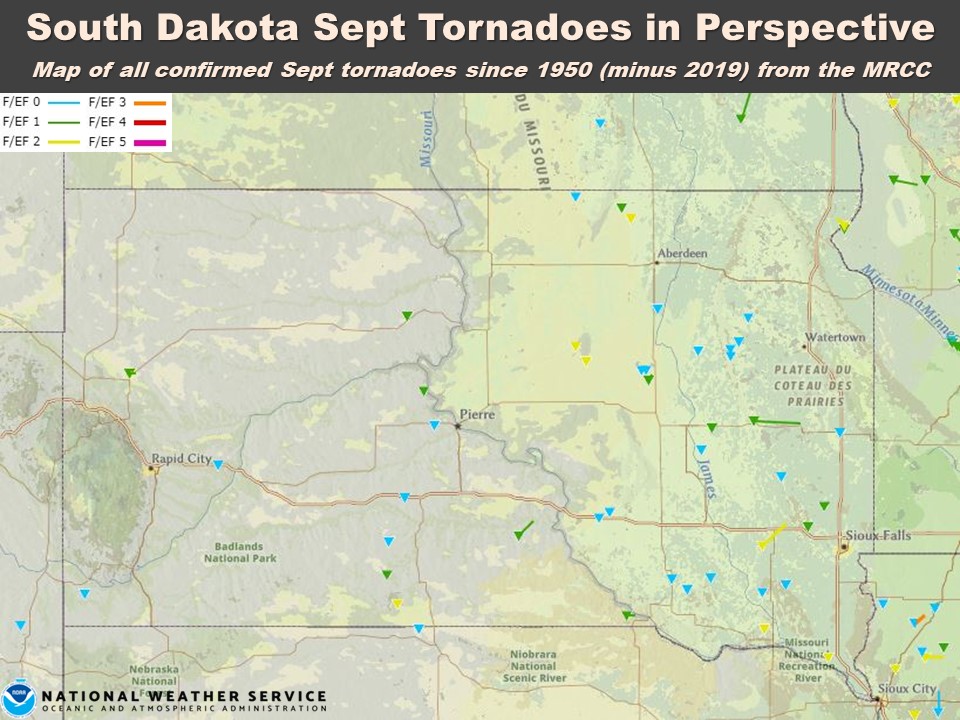
September tornadoes in South Dakota aren’t rare, but they aren’t exactly common either. By all measures, September 2019 was active. 6 tornadoes were confirmed on September 9th across Hamlin, Codington and Day Counties as a broken line of storms in the afternoon and then discrete cells in the evening developed. Find more on this event here: https://www.weather.gov/abr/September9thSevereWeatherSummary. The following night, 4 tornadoes were confirmed across southeastern South Dakota, including 3 in Sioux Falls, along with significant straight-line winds. More on this event here: https://www.weather.gov/fsd/20190910-tornado-siouxfalls. Find perspective on all this in a graphic further down the page.
|
September 2019 |
||||
|
Temperature Data |
Aberdeen |
Sisseton |
Wheaton |
Watertown |
|
Warmest Temperature / Date |
90°/ 5th |
89°/ 16th |
89°/ 17th |
86°/ 17th |
|
Coldest Temperature / Date |
34°/ 28th |
33°/ 28th |
37°/ 28, 29th |
35°/ 28th |
|
Average High / Departure from Normal |
74.2°/ +2.1° |
72.2°/ +0.0° |
71.6°/ +0.5° |
72.5°/ +1.9° |
|
Average Low / Departure from Normal |
51.6°/ +5.9° |
52.0°/ +4.7° |
53.9°/ +6.3° |
52.3°/ +4.9° |
|
Monthly Average / Departure from Normal |
62.9°/ +4.0° |
62.1°/ +2.4° |
62.8°/ +3.5° |
62.4°/ +3.4° |
|
Precipitation Data |
||||
|
Monthly Precipitation / Departure from Normal |
4.74”/ +2.55” |
6.31”/+3.77” |
6.15”/ +3.06” |
4.15”/+1.51” |
|
Most Precipitation in 24 hours / Date |
1.15”/ 7th |
2.17”/ 9th |
2.23”/ 9th |
1.21”/ 12th |
|
Monthly Snowfall / Departure from Normal |
N/A |
N/A |
N/A |
N/A |
|
Most Snow in 24 hours / Date |
N/A |
N/A |
N/A |
N/A |
|
Temperature Data |
Pierre |
Kennebec |
Mobridge |
Timber Lake |
|
Warmest Temperature / Date |
90°/ 15, 17th |
89°/ 15, 17th |
88°/ 5th |
88°/ 15, 16th |
|
Coldest Temperature / Date |
42°/ 23rd |
38°/ 26th |
40°/ 26, 28th |
38°/ 28th |
|
Average High / Departure from Normal |
76.4°/ -0.1° |
79.4°/ +0.2° |
74.9°/ +1.0° |
73.8°/ -1.2° |
|
Average Low / Departure from Normal |
53.0°/ +3.8° |
54.3°/ +5.0° |
52.5°/ +4.9° |
50.7°/ +3.3° |
|
Monthly Average / Departure from Normal |
64.7°/ +1.8° |
66.9°/ +2.6° |
63.7°/ +3.0° |
62.3°/ +1.1° |
|
Precipitation Data |
||||
|
Monthly Precipitation / Departure from Normal |
3.27”/ +1.40” |
3.06”/ +1.29” |
3.63”/ +2.09” |
3.88”/ +2.44” |
|
Most Precipitation in 24 hours / Date |
1.16”/ 9th |
1.72”/ 12th |
1.53”/ 12th |
1.14”/ 12th |
|
Monthly Snowfall / Departure from Normal |
N/A |
N/A |
N/A |
N/A |
|
Most Snow in 24 hours / Date |
N/A |
N/A |
N/A |
N/A |
September average temperature departures from normal, courtesy of the Midwestern Regional Climate Center
September total precipitation, courtesy of the Midwestern Regional Climate Center
September total precipitation departures from normal, courtesy of the Midwestern Regional Climate Center
September 2019 was very active compared to normal in terms of tornadoes. The stats below feature preliminary data as of October 1st, from the National Centers for Environmental Information's Storm Data

Map of all confirmed September tornadoes since records began in 1950, minus 2019, from the MRCC's Tornado Tracks page