
Severe thunderstorms capable of damaging winds will be possible from the Ozark Plateau east into portions of the Southeast today. Rounds of heavy thunderstorms ahead of a slow moving front will continue locally heavy rainfall and scattered flash flooding potential from the Ozarks to the Ohio and Tennessee Valleys today. Read More >
Weather History - December 22nd
Local and Regional Events:
December 22, 1990:
Strong northwest winds, combined with air temperatures below zero, created wind chills from -40 to -65 degrees over west-central Minnesota early in the day on the 22nd. Air temperatures were generally in the -20 to -25 degree range, with afternoon highs around 15 below zero.
December 22, 1990:
Strong northwest winds gusted to 35 miles per hour and caused near-whiteout conditions over a wide area of southwest and west-central Minnesota during the late afternoon on the 21st into the early morning of the 22nd. Several car accidents ensued. A 30-year old man was killed when he lost control of his truck and slid into a ditch in the near-blizzard conditions.
U.S.A and Global Events for December 22nd:
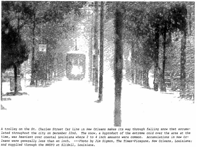
1989: The most significant cold spell of the century for the Deep South occurred from the 22 to the 26. New Orleans experienced 64 consecutive hours at or below 32 degrees Fahrenheit and a total of 81 out of 82 hours below freezing. A total of 15 hours was below 15 degrees with the lowest reading of 11 degrees on the morning of the 23rd. A low temperature of 8 degrees was recorded at Baton Rouge. Snow and sleet paralyzed transportation systems where as much as two to four inches of snow accumulated in Lafourche and Terrebonne Parishes. Snow and ice-covered the ground in New Orleans. The most significant impact was the breaking of water pipes in homes and businesses. Over 100 fires resulted in the New Orleans area within 24 hours due to a loss of water pressure and improperly utilized heating sources. Ice formed over shallow lakes and waterways where commercial fishing took heavy losses. Five weather-related deaths occurred in the service area during this rare Arctic outbreak.

1989: Between December 22 and December 24, 1989, deepening low pressure pulled a frigid arctic air mass into the southeastern United States. This sequence of events produced a historic snowstorm and a rare white Christmas across the region. At Charleston, South Carolina, the storm deposited 8 inches of snow – the greatest snowfall in modern history. At Savannah, Georgia, the storm total accumulation of 3.6 inches tied the greatest snowfall in modern history. Click HERE for more information from the NWS Office in Charleston, South Carolina.
2002: Heavy rains prompted flooding in the mountain city of Teresopolis, located about 90 km north of Rio de Janeiro in Brazil. A mudslide was responsible for 9 deaths and 50 injuries.
2004: Tremendous snows occurred in the Ohio Valley. The following cities set new records for their most significant snowstorm ever: Evansville, Indiana 22.3 inches, Dayton, Ohio 16.4 inches, and Paducah, Kentucky 14.2 inches. Other big snowfall totals were 31 inches at Liberty, Indiana, 28 inches at Buena Vista, Indiana, 24 inches at Greenville, Ohio, and 23 inches at Mansfield, Ohio. Click HERE for more information from the NWS Office in Paducah, Kentucky.
Click HERE for more This Day in Weather History from the Southeast Regional Climate Center.

