
Widespread life-threatening flash and urban flooding continues in south-central Texas, with considerable flooding impacts possible across central Texas. Wildfire smoke is impacting air quality across much of the Great Lakes region into southern New England and the Mid-Atlantic. Monsoonal thunderstorms may produce isolated to scattered flash flooding across the Southwest into the Great Basin. Read More >
Weather History - February 23
Local and Regional Events:
February 23, 1977:
A storm center developed over Colorado the morning of the 22nd and moved to southeast Nebraska by midnight Wednesday the 23rd, with snow and rain entering southern Minnesota. The low-pressure center advanced to Iowa by sundown and weakened somewhat with precipitation across Minnesota. Snow fell over the north, and a combination of rain and freezing rain was in the south. The low then intensified over southeast Minnesota during the nighttime of Thursday the 24th before continuing northeast into Wisconsin with snow and blowing snow over much of the state before ending on the 26th. There was a combination of rain, freezing rain, and the winds over southern Minnesota, with 4 to 12 inches of snow in the north. Freezing rain and the heavy icing on power lines caused the worst power failure in a decade in the twin cities, with 125,000 homes affected. Power outages occurred over numerous areas of southern and central Minnesota. Many roads were ice-covered with multiple vehicle accidents and cars in the ditch. Many roads were blocked or closed, with numerous schools closed. The ice storm also damaged many trees.
February 23, 2007:
A strong area of low pressure tracking across the central plains brought widespread snowfall to parts of central and much of northeast South Dakota along with west-central Minnesota. The precipitation initially began as freezing rain and sleet late in the evening of the 23rd as it lifted across the area through the morning of the 24th. The freezing rain and sleet then changed over to snow during the morning of the 24th. Thundersnow also occurred at some locations across the area. Snowfall amounts of 6 to 15 inches occurred by the end of the storm. Travel conditions became tough when the roads were slippery from the freezing rain and then the heavy snow. The South Dakota State Emergency Management, Highway Patrol, and Department of Transportation issued a travel advisory for no travel for Interstate-90 and many highways in central South Dakota. There were numerous accidents along the interstate. Some snowfall amounts included 7 inches at Browns Valley, 9 inches at Bryant, Webster, Wheaton, Artichoke Lake, and Tintah, 10 inches at Toronto, Roy Lake, Garden City, and Ortonville, 11 inches at Faulkton, 12 inches at Watertown, and 15 inches at Clear Lake.
February 23, 2010:
Pierre sets a new record with a streak of 84 consecutive days with high temperatures failing to reach 40 degrees. Click HERE for more information.
February 23, 2012:
An area of low-pressure sliding across the region brought heavy snow to much of central and north-central South Dakota. As a result, travel became difficult, with many schools canceled. Click HERE for snowfall reports.
U.S.A and Global Events for February 23:
1887: The Central Bureau of Meteorology of Rome began receiving the first reports of a massive earthquake from northern Italy Observers. The estimated magnitude earthquake of 6-7 killed at least 600 people in southern France and northern Italy. Click HERE for more information from Geophysical Journal International.
1977: A rare February tornado touched down briefly in Mason City, Iowa, inflicting F1 damage on a home and injuring one person inside. This is the only known February tornado on record in Iowa.
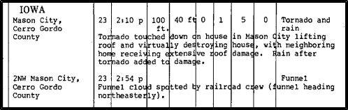
The image above is from Storm Data.
1995: Cyclone Bobby slams into the Western Australia coast, causing widespread flooding on February 23-24th, 1995. Some areas report up to 12 inches of rain from the storm.
Click HERE for more This Day in Weather History from the Southeast Regional Climate Center.

