
Record setting heat is expected over the next several days from the Intermountain West through the northern Plains. Furthermore, fire weather concerns increase with dry and breezy conditions. Meanwhile, heavy rainfall and severe thunderstorm threats for the Ohio/Tennessee Valleys, central Appalachians and Southeast today. The threat shifts to central Gulf Coast and across central Texas this week. Read More >
Local and Regional Events:
September 24, 1986:
Thunderstorms brought high winds along with several tornados to parts of western and central South Dakota from the late evening in the morning hours of the 25th. Winds were estimated up to 80 mph. Many trees and power poles were downed along with damage to many buildings. The tornadoes occurred near Newell, east of Cedar Butte, west of Murdo, 20 miles northwest of Pierre, and northwest of Ridgeview in Dewey County.
September 24, 1992:
South winds gusting to 50 to 55 mph across northeast South Dakota during the day toppled several trees and light poles. In Aberdeen, a front window was blown out of a store.
U.S.A and Global Events for September 24th:
1926: The temperature at Yellowstone Park drops to 9 degrees below zero, making it the coldest September reading ever recorded in the US.
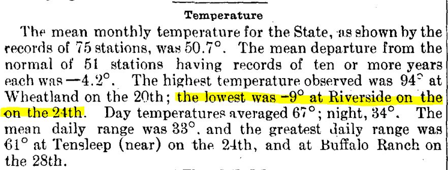
The image above is from the Climatological Data for Wyoming, September 1926.
1939: A thunderstorm on this day dropped 6.45 inches in six hours at Indio, CA. This rainfall preceded “El Cordonazo” or “The Lash of St. Francis”, an actual tropical storm. For the entire storm, which started on this day and ended on the 26th, four inches of rain fell across the deserts and mountains as a dying tropical cyclone moved across Baja California into southwestern Arizona. This storm was the second tropical cyclone to impact California during this month. A strong El Niño may have contributed to the activity. The tropical storm produced 50 mph winds over the ocean and estimated seas of 40 feet. September rain records were set in Los Angeles with 5.66 inches and 11.6 inches at Mt. Wilson. 45 people died from sinking boats, and harbors were damaged. Total damage was estimated at $2 million. Californians were unprepared and were alerted to their vulnerability to tropical storms. In response, the weather bureau established a forecast office for Southern California, which began operations in February of 1940.
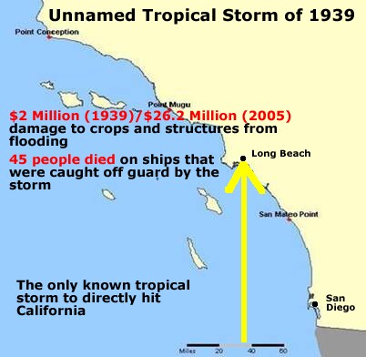
Track map of the 1939 California tropical storm. The image is courtesy of the National Weather Service Office in Los Angeles/Oxnard.
1956: Hurricane Flossy made landfall near Destin, Florida as a Category 1 storm. Click HERE for more information from the NWS Office in Mobile, Alabama.
1986: An F2 tornado, unusually strong for one in California, touched down just southeast of Vina on this day and traveled two miles through an agricultural area. A mobile home was destroyed, injuring a 22-year-old occupant. Eleven other buildings were damaged or demolished, and 50 acres of walnut orchards were flattened.

Above is the Vina tornado as seen to the west from US 99. The image is courtesy of Storm Data.
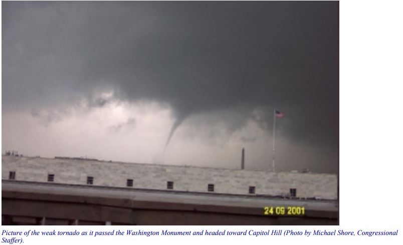
2001: A weak, F0 tornado passed in the sight of the Washington Monument. Soon after, an F3 tornado struck College Park, Maryland.
2005: Early on the morning of September 24, 2005, Major Hurricane Rita came ashore near the Texas/Louisiana border. Click HERE for more information from the Hurricane Research Division. Click HERE for more information from the NWS Office in Lake Charles, Louisiana.
Click HERE for more This Day in Weather History from the Southeast Regional Climate Center.

