|
.jpg)
Above: MODIS Visible Satellite Image of Hurricane Rita during the rapid intensifying trend at 2:20 PM CDT September 21, 2005.
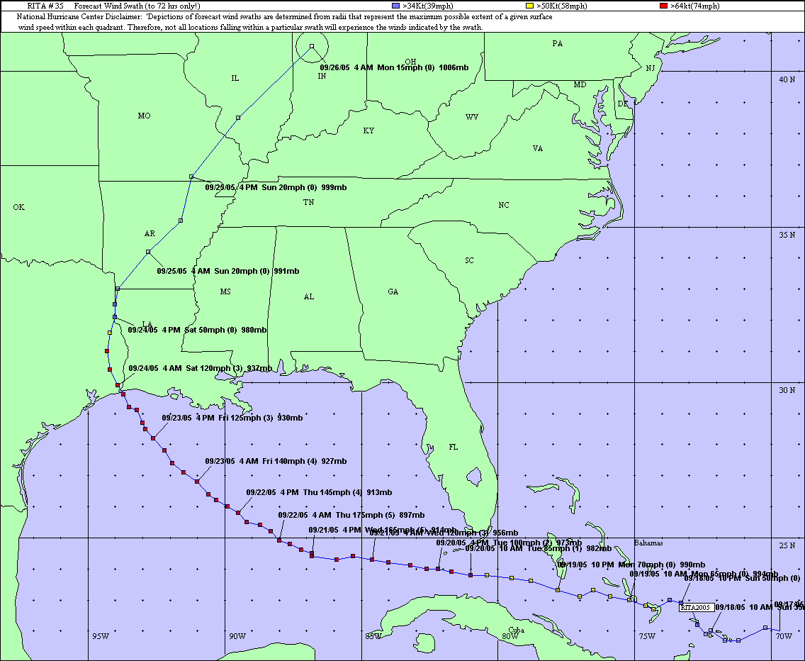
Hurricane Rita formed on September 18, 2005 east of the southeastern Bahamas, where Rita moved over the following day. Heading westward, Rita attained hurricane strength on September 20th while passing between the Florida Keys and Cuba. After entering the Gulf, Rita rapidly intensified over the very warm waters of the loop current and within an environment of very weak vertical wind shear. Rita reached a peak intensity of category 5 with sustained winds of 180 mph (155 knots) and a minimum pressure of 895 millibars (26.43 inches) at 10 PM CDT September 21st. This low pressure makes Rita the strongest hurricane ever recorded in the Gulf, and 4th strongest in the Atlantic Basin.
By September 22nd, the inner eyewall of Rita deteriorated and the system weakened to a category 4 with sustained winds of 145 mph (125 knots) by 1 PM CDT that day. By early September 23rd, a new outer eyewall had consolidated and the hurricane had grown in size, but weakened a bit further to a Category 3 with sustained winds of 125 mph (110 knots) by 1 PM CDT. Due to increasing southwesterly wind shear and slightly cooler waters, steady weakening continued for the remainder of the day.
Rita made landfall across western Cameron Parish just east of the Texas and Louisiana border around 2:40 AM CDT Saturday September 24, 2005 as a category 3 hurricane with sustained winds of 115 mph (100 knots) and a minimum pressure of 937 millibars (27.67 inches). Rita was the strongest hurricane to strike Southeast Texas and Southwest Louisiana since Hurricane Audrey on June 27, 1957. Preliminary information suggests that Rita was comparable to Audrey in many ways and perhaps worse in that the effects were felt across a larger area. A lot has changed in the 48 years since Audrey, and many lessons have been learned from her and other disasters that have affected this area during that time.
Hurricane Rita caused seven direct United States fatalities, one in the WFO Lake Charles County Warning Area (CWA). Over a hundred indirect fatalities were associated with the evacuation and aftermath of Hurricane Rita within the United States. Six individuals in Beaumont, Texas succumbed to carbon monoxide poisoning when they used a generator inside their building. Although any loss of life is tragic, these numbers stand in stark contrast to the hundreds of lives lost due to Hurricane Audrey. Clearly, the improvements made to emergency preparedness and response to warnings has made a difference. The National Weather Service in Lake Charles looks forward to continuing and strengthening the partnerships we have formed with local emergency management, local media, and the residents of this region.
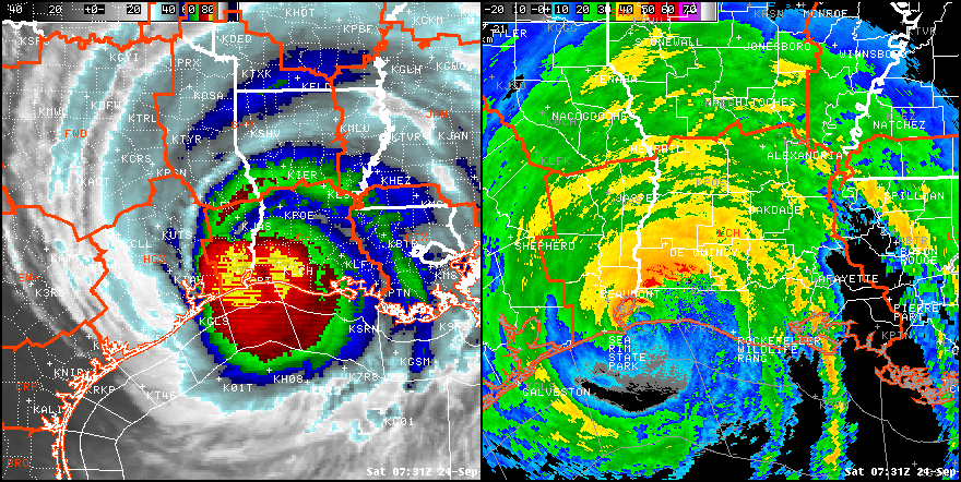
Above Left: GOES-12 Infrared Satellite Image; Above Right: Lake Charles WSR-88D Radar Image of Hurricane Rita at 2:31 AM CDT September 24, 2005.
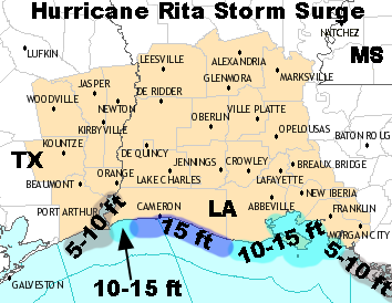
Storm surge values of 12 to 18 feet across most of Cameron parish, and 10 to 12 feet across most of Vermilion parish devastated these areas, with Holly Beach, LA completely leveled to the ground. Storm surge values of 8 to 10 feet across eastern Jefferson and Orange counties in Southeast Texas caused considerable damage to Sabine Pass and Bridge City.
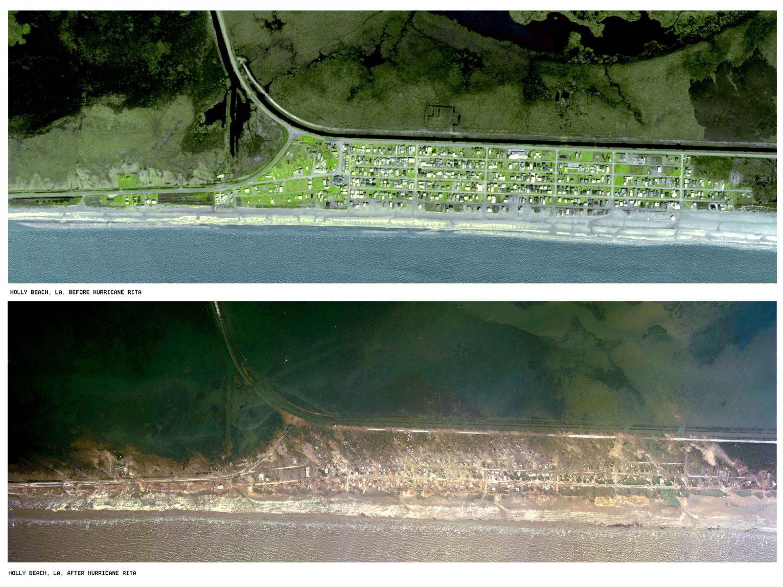
Above: Holly Beach, LA aerial photo showing the town before and after Hurricane Rita. Not a single building was left standing. Photo from USGS.
After making landfall across western Cameron parish, the eye of Rita passed over a majority of Southeast Texas from Sabine Lake to Sam Rayburn Reservoir. In fact, the eye of Rita passed over Southeast Texas Region Airport south of Beaumont, TX, producing a record lowest pressure reading of 952.3 millibars (28.12 inches) at 3:09 AM CDT September 24, 2005. An un-official report of 948.9 millibars (28.02 inches) was recorded by the vessel, Cape Vincent, docked at the port of Beaumont at 3:30 AM CDT.
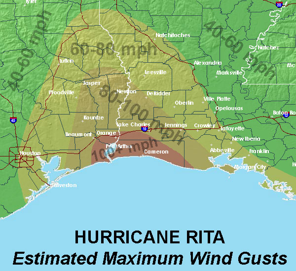
Wind damage was extensive across Southwest Louisiana and Southeast Texas as well, with a large area receiving category 1-2 hurricane force winds (see estimated wind gust graphic). Exact measurements were not possible in some areas due to power outages and failures of automated weather observing sites, and coastal tide gauges being washed away by the storm surge.
This section of our webpage has been created to provide the residents of Southeast Texas and Southwest Louisiana information about Hurricane Rita and its affect on the area. Below are some links that will bring you to pages with additional information of interest, along with a collection of image galleries (listed below) with pictures taken by the office staff.
We would like to extend our condolences to those who have and continue to suffer as a result of this destructive hurricane.
|


