Widespread life-threatening flash and urban flooding continues in south-central Texas, with considerable flooding impacts possible across central Texas. Wildfire smoke is impacting air quality across much of the Great Lakes region into southern New England and the Mid-Atlantic. Monsoonal thunderstorms may produce isolated to scattered flash flooding across the Southwest into the Great Basin. Read More >
Meteorological Comparison of Hurricanes Audrey and Rita
Compiled by:
Donovan Landreneau, Forecaster
Sam Shamburger, Forecaster
Comparing Hurricane Audrey to Hurricane Rita
June 27, 1957 to September 23-24, 2005
|
Minimum Sea Level Pressure |
||||
| Location | Hurricane Audrey | Hurricane Rita | ||
| inches of mercury | millibars | inches of mercury | millibars | |
| Alexandria, LA | 29.00" | 982.1 mb | 29.28" | 991.5 mb |
| Baton Rouge, LA | 29.54" | 1000.3 mb | 29.46" | 997.6 mb |
| Cameron, LA | *28.32" | *959 mb | *<28.06" | *<950 mb |
| Galveston, TX | 29.13" | 986.5 mb | **29.37" | **994.6 mb |
| Lafayette, LA | 29.34" | 993.6 mb | 29.30" | 992.2 mb |
| Lake Charles, LA | 28.69" | 971.4 mb | 28.59" | 968.2 mb |
| Lufkin, TX | 29.34" | 993.6 mb | **29.27" | **991.2 mb |
| Monroe, LA | 29.07" | 984.4 mb | 29.47" | 998.0 mb |
| New Orleans, LA | 29.65" | 1004.2 mb | 29.60" | 1002.4 mb |
| Port Arthur, TX (SE TX Regional) |
28.67" | 970.9 mb | 28.12" | 952.3 mb |
| Shreveport, LA | 29.28" | 991.3 mb | 29.05" | 983.8 mb |
|
* estimated/unofficial |
||||
|
Maximum Sustained Winds & Wind Gusts |
|||||
| Location | Data Source | Hurricane Audrey | Hurricane Rita | ||
| Maximum Sustained Wind (1-minute avg.) |
Peak Wind Gust | Maximum Sustained Wind (2-minute avg.) |
Peak Wind Gust | ||
| Alexandria, LA | NWS | 48 mph | 64 mph | 50 mph | 62 mph |
| Baton Rouge, LA | NWS | 40 mph | 69 mph | 41 mph | 53 mph |
| Cameron, LA | NOAA | unknown | unknown | **77 mph | **112 mph |
| Galveston, TX | NWS | 58 mph | 76 mph | **45 mph | **62 mph |
| Lafayette, LA | NWS | 58 mph | 86 mph | 51 mph | 59 mph |
| Lake Charles, LA | NWS | 75 mph | 97 mph | 76 mph | 96 mph |
| Lufkin, TX | NWS | 20 mph | 32 mph | **33 mph | **50 mph |
| Monroe, LA | NWS | 35 mph | 63 mph | 31 mph | 43 mph |
| New Orleans, LA | NWS | 35 mph | 53 mph | 35 mph | 48 mph |
| Orange, TX | FCMP | unknown | *100 mph | 75 mph | 98 mph |
| Port Arthur, TX (SE TX Regional) |
NWS | 72 mph | 85 mph | 81 mph | 105 mph |
| Shreveport, LA | NWS | 30 mph | 51 mph | 40 mph | 53 mph |
|
* estimated/unofficial |
|||||
|
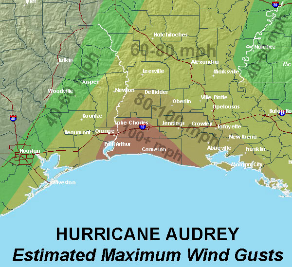
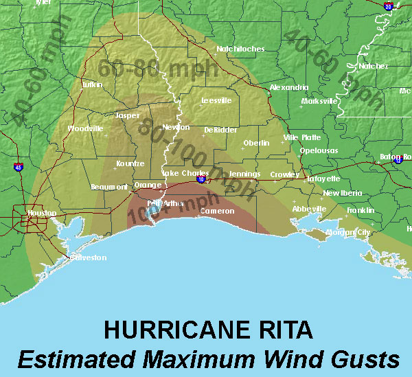
Estimated Maximum Wind Gust maps |
|
| Hurricane Audrey | Hurricane Rita |
|
|
|
|
Storm Surge |
||
| Location | Hurricane Audrey | Hurricane Rita |
| MSL | NGVD88 | |
| Calcasieu Pass, LA | 12.1 ft | *6.7 ft |
| Cameron, LA | 10.6 ft | 16.2 ft |
| Cypremort Point, LA | 10.2 ft | 12.1 ft |
| Grand Chenier, LA | 13.9 ft | 14.5 ft |
| Hackberry, LA | 6.7 ft | 8.0 ft |
| Intracoastal City, LA | 8.1 ft | 11.0 ft |
| Johnsons Bayou, LA | 10.4 ft | 12.4 ft |
| Lake Charles, LA | 7.0 ft | 8.4 ft |
| Morgan City, LA | 8.5 ft | 6.1 ft |
| Oak Grove, LA | 12.4 ft | 13.4 ft |
| Pecan Island, LA | 10.9 ft | 10.4 ft |
| Sabine Pass, TX | 9.4 ft | 9.8 ft |
|
* last data recorded before equipment failure |
||
|
Rainfall |
|||
| Location | Data Source | Hurricane Audrey | Hurricane Rita |
| Alexandria Power Plant, LA | NWS COOP | 3.70" | *7.60" |
| Baton Rouge, LA | NWS | 1.51" | 9.30" |
| Galveston, TX | NWS | 1.85" | * |
| Lafayette, LA | NWS | 3.69" | 6.24" |
| Lake Charles, LA | NWS | 7.57" | 7.68" |
| Lufkin, TX | NWS | 0.27" | 5.51" |
| Monroe, LA | NWS | 2.85" | 3.50" |
| New Orleans, LA | NWS | 0.15" | 2.07" |
| Port Arthur, TX | NWS | 6.90" | 8.89" |
| Shreveport, LA | NWS | 0.45" | 5.54" |
| Monroe, LA | NWS | 2.85" | 3.50" |
|
* official data unavailable due to equipment failure |
|||