Widespread life-threatening flash and urban flooding continues in south-central Texas, with considerable flooding impacts possible across central Texas. Wildfire smoke is impacting air quality across much of the Great Lakes region into southern New England and the Mid-Atlantic. Monsoonal thunderstorms may produce isolated to scattered flash flooding across the Southwest into the Great Basin. Read More >
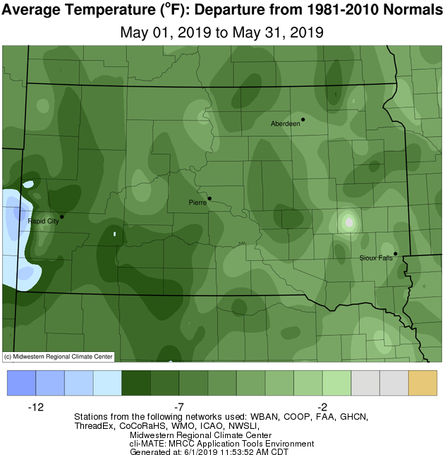
May 2019 featured predominantly cool temperatures, anywhere from 4 to 7 degrees below normal, thanks to a jet stream pattern that kept the area on the cold side of several storm systems. Several locations ranked in the top 10 coldest Mays on record: Kennebec 10th, Sisseton 8th, Timber Lake tied 6th, and Pierre 3rd. Record cold daily low temps were recorded at Aberdeen and Sisseton on the 7th (24° and 26° respectively), and numerous record cold daily max temps were recorded from the 18th through the 22nd: Pierre on the 20th, 21st and 22nd (49°, 47°, 53°), Aberdeen on the 19th (46°), Mobridge on the 22nd (53°), Sisseton on the 19th (44°), Wheaton on the 20th (48°), Kennebec on the 19th, 20th, 21st and 22nd (47°, 52°, 46° 52°), and Timber Lake on the 18th and 22nd (45° and 48°).
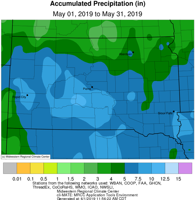
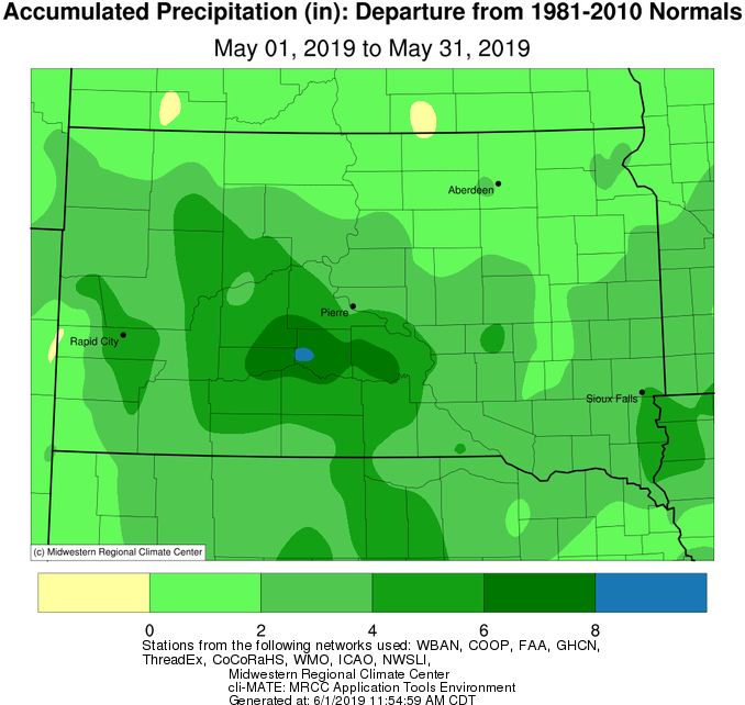
Very wet weather accompanied the cooler temperatures, and a couple days of accumulating snow resulted (not unheard of in South Dakota). Portions of central South Dakota picked up a couple inches on May 6th and portions of Deuel County followed suit on May 8th, where an estimated 4” fell at Astoria. Above average total precipitation for May was observed at all locations, but the greatest departure was across central South Dakota where an impressive 4 to 8 inches of surplus rain fell. This May will go down as the second wettest on record in Pierre (7.24" in 1982) and the wettest on record in Kennebec (9.54”, surpassing the old record of 7.2” in 1942). This averages out to just over 0.30” per day. Year-to-date, Watertown has had 12.58” of moisture which ranks as the 4th wettest start to the year on record, Pierre has had 13.85” of moisture which ranks as the wettest start to the year on record, and Kennebec 15.28” which also ranks as the wettest. For perspective, Pierre averages 20.01” of total moisture each year, and Kennebec averages 19.63 inches. Daily record rainfalls this May occurred at: Pierre on the 21st (1.54”), Sisseton on the 18th (1.17”) and Kennebec on the 27th (4.03”).
Unfortunately, all this moisture exacerbated issues associated with already wet/nearly saturated soils which carried over from April. River flooding remained an issue throughout May as round after round of rain impacted the area, and numerous county roads were impassable at one point or another. While widespread 0.5” to 1” plus rainfall events took place on the 7-8th, 17/18th and 21/22nd, the climax rain event, at least for central South Dakota, took place on the evening of May 26th. Slow-moving thunderstorms dumped heavy rains in excess of 4” in some cases across Jones/Lyman counties, including 4.34" at Murdo. Kennebec in particular observed flooding in response as Medicine Creek swelled well past its banks. Pierre/Fort Pierre also observed street flooding on the 31st after about an inch of rain fell in an hour’s time due to a passing thunderstorm.
Climatologically, May is an active month for severe weather across central/northeastern South Dakota and west central Minnesota, but there was a distinct lack of it this year. Only two Severe Thunderstorm Warnings have been issued by NWS Aberdeen this May (16th for Marshall/Roberts Counties and again on the 31st for Hamlin/Deuel Counties). Finally, of note, smoke from Canadian wildfires spread across the Northern Plains May 29-31st due to northwest winds aloft which transported the smoke southeastward. Hazy skies and red sunrises/sunsets resulted.
|
May 2019 |
||||
|
Temperature Data |
Aberdeen |
Sisseton |
Wheaton |
Watertown |
|
Warmest Temperature / Date |
89°/ 30th |
88°/ 30th |
86°/ 30th |
85°/ 31st |
|
Coldest Temperature / Date |
24°/ 7th |
26°/ 7th |
31°/ 7th |
27°/ 7th |
|
Average High / Departure from Normal |
64.4°/ -4.3° |
63.4°/ -6.0° |
63.1°/ -5.4° |
61.9°/ -5.7° |
|
Average Low / Departure from Normal |
41.1°/ -3.0° |
42.0°/ -3.1° |
44.8°/ -0.9° |
41.5°/ -3.1° |
|
Monthly Average / Departure from Normal |
52.8°/ -3.6° |
52.7°/ -4.6° |
54.0°/ -3.1° |
51.7°/ -4.4° |
|
Precipitation Data |
||||
|
Monthly Precipitation / Departure from Normal |
4.15”/ +1.04” |
4.11”/+1.39” |
3.91”/ +1.23” |
3.99”/+1.35” |
|
Most Precipitation in 24 hours / Date |
1.11”/ 18th |
1.17”/ 18th |
1.49”/ 18th |
0.89”/17th |
|
Monthly Snowfall / Departure from Normal |
0.0”/ +0.0” |
0.0”/ +0.0” |
0.0” / +0.0” |
0.0”/ +0.0” |
|
Most Snow in 24 hours / Date |
N/A |
N/A |
N/A |
N/A |
|
Temperature Data |
Pierre |
Kennebec |
Mobridge |
Timber Lake |
|
Warmest Temperature / Date |
87°/ 15th |
86°/ 15th |
87°/ 15th |
84°/ 15th |
|
Coldest Temperature / Date |
23°/ 2nd |
25°/ 2nd |
28°/ 7th |
27°/ 2nd |
|
Average High / Departure from Normal |
62.6°/ -7.6° |
64.0°/ -8.9° |
64.0°/ -4.4° |
62.3°/ -7.4° |
|
Average Low / Departure from Normal |
41.9°/ -3.8° |
42.6°/ -3.3° |
42.1°/ -1.8° |
39.9°/ -4.1° |
|
Monthly Average / Departure from Normal |
52.3°/ -5.6° |
53.3°/ -6.1° |
53.0°/ -3.2° |
51.1°/ -5.8° |
|
Precipitation Data |
||||
|
Monthly Precipitation / Departure from Normal |
6.78”/ +3.63” |
9.54”/ +6.38” |
3.23”/ +0.41” |
4.73”/ +1.89” |
|
Most Precipitation in 24 hours / Date |
1.54”/ 21st |
4.03”/ 27th |
0.90”/ 17th |
0.78”/ 18th |
|
Monthly Snowfall / Departure from Normal |
0.0” / +0.0” |
0.0” /+0.0” |
0.0”/ -0.1” |
0.0”/ -0.2” |
|
Most Snow in 24 hours / Date |
N/A |
N/A |
N/A |
N/A |
May 2019 average temperature departures from normal, from the Midwestern Regional Climate Center
May 2019 total precipitation, from the Midwestern Regional Climate Center
May 2019 precipitation departures from normal, from the Midwestern Regional Climate Center
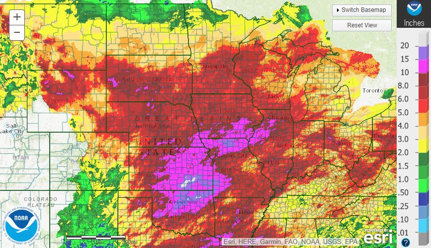
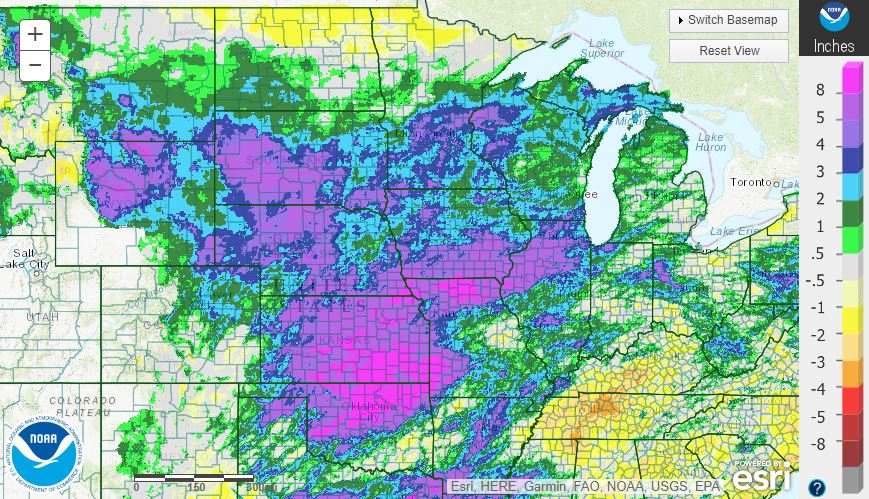
A wider perspective from https://water.weather.gov/precip reveals just how staggeringly wet much of the country's mid-section has been this May. A pattern of continuous low pressure system after low pressure system produced rounds of thunderstorms and upwards of 20" of rain across portions of Kansas and Oklahoma.
The first image below displays multi-sensor precipitation totals for May 2019, and the second is of precipitation departures.