Overview
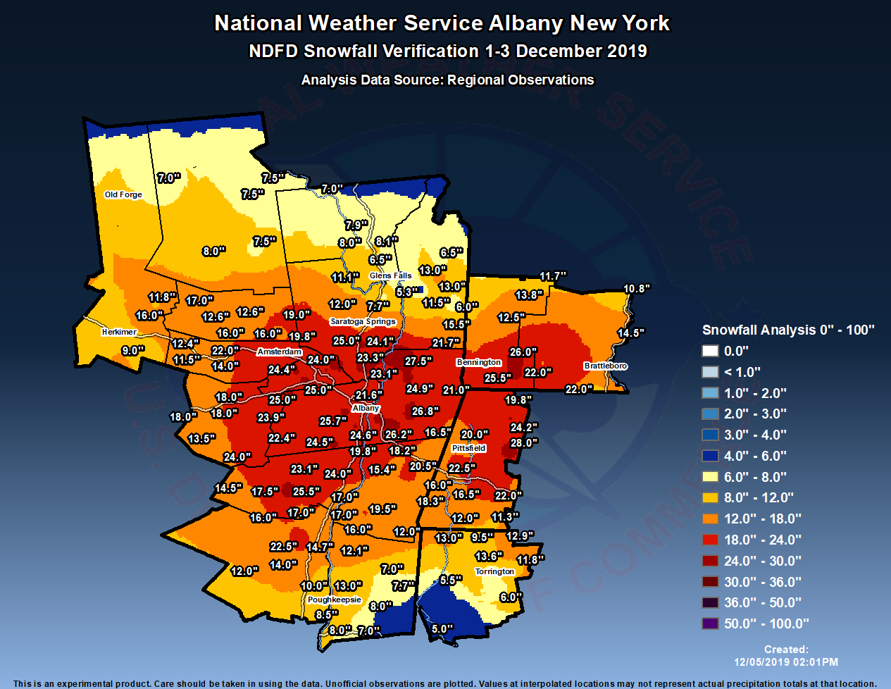
A major winter storm impacted eastern New York and western New England December 1-3, 2019. Snowfall began during the late morning and early afternoon of the 1st ahead of a weakening low pressure system approaching from the western Great Lakes. Snowfall rates of 1-2" per hour occurred from the afternoon into the evening, with the heaviest along the I-90 corridor. As the primary low pressure system weakened, it transferred its energy to a coastal low, which strengthened as it remained nearly stationary for much of the 2nd. This allowed snow to continue to accumulate throughout the day. As the low finally pulled away late on the 2nd into the early morning hours of the 3rd, one final heavy snow band crossed the area before the snow finally pulled out prior to daybreak on the 3rd.
Storm total snowfall amounts were heaviest in the central Mohawk Valley, Helderbergs, northeastern Catskills, Capital District, southern Vermont, and the Berkshires, where totals of 18-28" were common. The 22.6" recorded at Albany International Airport made this the 8th largest snowstorm on record, the 4th largest December storm, and the largest since the March 1993 superstorm. It snowed for 39 hours and 14 minutes consecutively. Many schools were closed for two consecutive days, and numerous flights were delayed or cancelled. The governor declared a state of emergency for several of the hard-hit counties, and deployed the National Guard to assist in cleanup efforts. Speed restrictions were also placed on area interstate highways. Amounts of 8-18" were common elsewhere, except for southern portions of Dutchess and Litchfield Counties due to warmer temperatures and mixed precipitation, and northern portions of Herkimer, Hamilton, Warren, and Washington Counties which were on the fringe of the heavier precipitation.
Radar
KENX radar loop 10:30 am December 1 through 5 am December 3
 |
| Courtesy UCAR |
Storm Reports
Public Information Statement
Spotter Reports
National Weather Service Albany NY
1203 PM EST Tue Dec 03 2019

The following are unofficial observations taken during the past 52
hours for the storm that has been affecting our region. Appreciation
is extended to highway departments, cooperative observers, Skywarn
spotters and media for these reports. This summary also is available
on our home page at weather.gov/albany

********************STORM TOTAL SNOWFALL********************

LOCATION          STORM TOTAL     TIME/DATE   COMMENTS
                     SNOWFALL           OF
                     /INCHES/   MEASUREMENT

CONNECTICUT

...Litchfield County...
   Winsted               13.6   630 AM 12/03  Trained Spotter
   Canaan                13.0   519 AM 12/03  WeatherNet6
   1 NE Colebrook        12.9   700 AM 12/03  CoCoRaHS
   3 SW New Hartford Ce  11.8   700 AM 12/03  CoCoRaHS
   Bakersville           11.8   700 AM 12/03  Co-Op Observer
   4 ESE Canaan           9.5   700 AM 12/03  CoCoRaHS
   Torrington             6.9   732 AM 12/03  Twitter
   1 SSE Torrington       6.6   700 AM 12/03  CoCoRaHS
   2 SW Harwinton         6.0   500 AM 12/03  Trained Spotter
   2 WNW Warren           5.5   700 AM 12/03  CoCoRaHS
   5 SSW New Milford      5.0   800 AM 12/03  CoCoRaHS

MASSACHUSETTS

...Berkshire County...
   Peru                  28.0  1000 AM 12/03  Amateur Radio
   Savoy                 24.2  1159 AM 12/03  WeatherNet6
   Lenox                 22.5   701 AM 12/03  Twitter
   Becket                22.0  1148 AM 12/03  WeatherNet6
   4 SE Lee              21.3   720 AM 12/03  CoCoRaHS
   1 NNW Cheshire        20.0   700 AM 12/03  CoCoRaHS
   Clarksburg            19.8   517 AM 12/03  WeatherNet6
   Williamstown          19.5   730 AM 12/03  Twitter
   Great Barrington      18.3   753 AM 12/03  WeatherNet6
   Hancock               16.5   524 AM 12/03  WeatherNet6
   3 N Great Barrington  16.5   700 AM 12/03  CoCoRaHS
   NNE Stockbridge       16.0   600 AM 12/03  CoCoRaHS
   Pittsfield            14.5   845 AM 12/03  Trained Spotter
   1 NNW Ashley Falls    12.0  1032 AM 12/03  Public
   3 S Sandisfield       11.3   755 AM 12/03  Twitter

NEW YORK

...Albany County...
   1 WNW Delmar          25.7   720 AM 12/03  Trained Spotter
   Knox                  25.0   516 AM 12/03  WeatherNet6
   2 N Selkirk           24.6   645 AM 12/03  NWS Employee
   Alcove Reservoir      24.5   830 AM 12/03  Co-Op Observer
   1 SW Albany           23.9   700 AM 12/03  CoCoRaHS
   2 SW Voorheesville    23.8   623 AM 12/03  1.50 inches liq equiv.
   Boght Corners         23.1   622 AM 12/03  Storm Total
   3 SW Glenmont         23.0   700 AM 12/03  CoCoRaHS
   Albany Intl AP        22.6   700 AM 12/03  ASOS
   2 NNW Rensselaervill  22.4   700 AM 12/03  CoCoRaHS
   1 WNW Albany          22.3   700 AM 12/03  NWS Employee
   Delmar                22.0   618 AM 12/03  WeatherNet6
   Colonie               22.0   730 AM 12/03  Trained Spotter
   2 W Albany            21.5   615 AM 12/03  NWS Employee
   South Berne           21.0   457 AM 12/03  WeatherNet6
   Albany                20.8   700 AM 12/03  storm total
   Ravena                19.8   835 AM 12/03  Meteorologist
   3 NW Guilderland      19.8   758 AM 12/03  storm total
   Altamont              19.1   800 AM 12/03  Storm total

...Columbia County...
   Austerlitz            20.5   630 AM 12/03  WeatherNet6
   8 S Hudson            19.5   700 AM 12/03  CoCoRaHS
   3 N Valatie           18.2   700 AM 12/03  CoCoRaHS
   1 SSW Livingston      17.0   745 AM 12/03  CoCoRaHS
   Livingston            17.0   845 AM 12/03  Trained Spotter
   Taghkanic             16.3  1149 AM 12/03  WeatherNet6
   2 W Clermont          16.0   815 AM 12/03  Trained Spotter
   Chatham               15.4   840 AM 12/03  Trained Spotter
   Germantown            14.0   628 AM 12/03  WeatherNet6
   Canaan                13.0   501 AM 12/03  Storm Total
   Ancramdale            12.0  1143 AM 12/03  WeatherNet6

...Dutchess County...
   Red Hook              16.0   538 AM 12/03  WeatherNet6
   1 NNE Red Hook        15.8   700 AM 12/03  CoCoRaHS
   3 N Rhinebeck         14.7   700 AM 12/03  CoCoRaHS
   Poughkeepsie          13.0  1028 AM 12/03  WeatherNet6
   Rhinebeck             12.1   720 AM 12/03  Trained Spotter
   2 SSE Poughkeepsie    10.9   930 AM 12/03  Trained Spotter
   5 S Poughkeepsie      10.1   900 AM 12/03  CoCoRaHS
   Hyde Park             10.0   824 AM 12/03  Trained Spotter
   1 SW Red Oaks Mill     8.5   645 AM 12/03  Trained Spotter
   4 SSE Poughkeepsie     8.5   500 AM 12/03  CoCoRaHS
   Lagrange               8.0   808 AM 12/03  Twitter
   2 ESE Wappingers Fal   8.0   700 AM 12/03  CoCoRaHS
   3 SE Millbrook         7.7   700 AM 12/03  CoCoRaHS
   Hopewell Junction      7.0  1059 AM 12/03  Twitter
   3 NE Millbrook         7.0   545 AM 12/03  CoCoRaHS
   Poughquag              4.0   830 AM 12/03  storm total

...Fulton County...
   Broadalbin            19.0   747 AM 12/03  WeatherNet6
   Stratford             17.0   638 PM 12/02  WeatherNet6
   Johnstown             16.0   457 PM 12/02  WeatherNet6
   Perth                 16.0   919 PM 12/02  WeatherNet6
   7 NW GLOVERSVILLE     12.6   800 AM 12/03  Co-Op Observer
   Gloversville 7nw      12.6   800 AM 12/03  Co-Op Observer

...Greene County...
   East Jewett           25.5   700 AM 12/03  storm total
   Cairo                 24.0   635 AM 12/03  WeatherNet6
   3 E Freehold          23.1   530 AM 12/03  CoCoRaHS
   Greenville Center     20.5   516 AM 12/03  WeatherNet6
   West Kill             17.5   650 AM 12/03  WeatherNet6
   Catskill              17.0   947 AM 12/03  WeatherNet6
   5 SSE Tannersville    17.0   730 AM 12/03  CoCoRaHS
   Halcott Center        14.5   832 AM 12/03  WeatherNet6

...Hamilton County...
   Piseco                 8.0   640 AM 12/03  WeatherNet6
   2 SW Indian Lake       7.5   820 AM 12/03  Co-Op Observer
   Indian Lake            7.5   820 AM 12/03  Co-Op Observer
   Wells                  7.5   701 AM 12/03  WeatherNet6
   Inlet                  7.0   652 AM 12/03  Storm Total

...Herkimer County...
   Dolgeville            16.0   218 AM 12/03  Trained Spotter
   2 NW Salisbury Cente  11.8   600 AM 12/03  CoCoRaHS
   4 E Jordanville        9.0   800 AM 12/03  CoCoRaHS

...Montgomery County...
   Amsterdam             22.1   724 AM 12/03  WeatherNet6
   Fonda                 22.0   556 AM 12/03  WeatherNet6
   Palatine Bridge       14.0   519 AM 12/03  WeatherNet6
   SE Fort Plain         12.4   700 AM 12/03  CoCoRaHS
   Fort Plain            11.5   714 PM 12/02  WeatherNet6

...Rensselaer County...
   Schaghticoke          27.5   725 AM 12/03  Meteorologist
   Averill Park          26.8   800 AM 12/03  Meteorologist
   East Schodack         26.2   700 AM 12/03  Trained Spotter
   7 NE Troy             24.9   700 AM 12/03  CoCoRaHS
   East Greenbush        24.5   606 AM 12/03  Trained Spotter
   1 WNW Averill Park    23.9   800 AM 12/03  CoCoRaHS
   1 N Sycaway           22.2   700 AM 12/03  NWS Employee
   2 NNE Troy            22.2   800 AM 12/03  CoCoRaHS
   Buskirk               21.7   700 AM 12/03  Co-Op Observer
   1 E Troy              21.6   700 AM 12/03  CoCoRaHS
   Berlin                21.0   630 AM 12/03  Facebook
   Center Brunswick      20.2  1133 AM 12/03  WeatherNet6
   West Sand Lake        19.0   630 AM 12/03  Storm Total

...Saratoga County...
   2 S Clifton Park Cen  27.2   810 AM 12/03  Retired NWS Emp.
   Malta                 25.0   717 AM 12/03  WeatherNet6
   2 NNE Round Lake      24.1   700 AM 12/03  CoCoRaHS
   Burnt Hills           24.0   800 AM 12/03  Meteorologist
   Ballston Lake         23.3   757 AM 12/03  storm total
   3 S Clifton Park      23.0   630 AM 12/03  CoCoRaHS
   Charlton              22.0  1007 PM 12/02  WeatherNet6
   Galway                19.8   545 AM 12/03  WeatherNet6
   1 S Saratoga Springs  15.7   600 AM 12/03  CoCoRaHS
   Saratoga Springs      15.7   642 AM 12/03  WeatherNet6
   2 W Greenfield Cente  12.0   820 AM 12/03  CoCoRaHS
   1 WNW Gansevoort       7.7   600 AM 12/03  CoCoRaHS

...Schenectady County...
   East Glenville        27.2   700 AM 12/03  Meteorologist
   Glenville             26.0   613 AM 12/03  WeatherNet6
   1 SSW Aqueduct        25.3   630 AM 12/03  storm total 25.3 inches
   Princetown            25.0   800 AM 12/03  Twitter
   4 SSW Pattersonville  24.4   800 AM 12/03  CoCoRaHS
   Niskayuna             24.0   700 AM 12/03  Co-Op Observer
   Schenectady           23.5   921 AM 12/03  WeatherNet6
   Delanson              23.5   433 AM 12/03  WeatherNet6
   Schenectady-GE Plot   23.4   850 AM 12/03  storm total
   3 NNE Delanson        23.1   640 AM 12/03  Meteorologist
   South Schenectady     22.5   500 AM 12/03  Storm Total.
   1 NW Rotterdam        22.5   500 AM 12/03  CoCoRaHS
   3 SSE Niskayuna       22.3   700 AM 12/03  CoCoRaHS
   1 NNE Hawthorne Hill  21.0   715 AM 12/03  NWS Employee
   1 NW Scotia           20.0   600 AM 12/02  CoCoRaHS
   1 S Hawthorne Hill    19.7   500 AM 12/03  Trained Spotter
   S Niskayuna           18.5   700 AM 12/03  CoCoRaHS
   Delanson 2ne          18.0   700 AM 12/03  Co-Op Observer

...Schoharie County...
   Gilboa                24.0  1042 PM 12/02  WeatherNet6
   Middleburgh           23.9   701 AM 12/03  WeatherNet6
   Schoharie             23.2   720 AM 12/03  Co-Op Observer
   2 ESE Cobleskill      18.0   735 AM 12/03  Co-Op Observer
   Cobleskill            18.0   735 AM 12/03  Co-Op Observer
   Richmondville         18.0   418 AM 12/03  WeatherNet6
   Jefferson             13.5   555 AM 12/03  WeatherNet6

...Ulster County...
   Spencertown           22.5   550 AM 12/03  WeatherNet6
   Phoenicia             16.0   604 AM 12/03  WeatherNet6
   2 WNW Rosendale Vill  14.0   800 AM 12/03  CoCoRaHS
   Ulster Park           12.2   749 AM 12/03  WeatherNet6
   4 N Kerhonkson        12.0   700 AM 12/03  CoCoRaHS
   2 S Hurley            11.9   700 AM 12/03  CoCoRaHS
   Esopus                10.8   700 AM 12/03  storm total

...Warren County...
   Lake Luzerne          11.1   600 AM 12/03  Co-Op Observer
   1 N Lake George        8.1   600 AM 12/03  CoCoRaHS
   Warrensburg            8.0   442 PM 12/02  WeatherNet6
   2 WNW Warrensburg      7.9   800 AM 12/03  CoCoRaHS
   5 SE North Creek       7.0   700 AM 12/03  Co-Op Observer
   5 ESE Lake George      6.5   700 AM 12/03  CoCoRaHS

...Washington County...
   Cambridge             15.5   200 PM 12/02  Trained Spotter
   5 SW NORTH HEBRON     13.0   700 AM 12/03  Co-Op Observer
   Hebron                13.0   644 AM 12/03  WeatherNet6
   Greenwhich            11.5  1017 AM 12/03  WeatherNet6
   Hartford               6.5   751 AM 12/03  Twitter
   Salam                  6.0   504 PM 12/02  WeatherNet6
   Hudson Falls           5.5   436 AM 12/03  WeatherNet6
   Argyle                 5.3   700 AM 12/03  Trained Spotter

VERMONT

...Bennington County...
   Woodford              26.0   720 AM 12/03  WeatherNet6
   5 NW Readsboro        25.5  1058 AM 12/03  Meteorologist
   5 NNE Stamford        20.6   400 PM 12/02  CoCoRaHS
   3 ENE Manchester      13.8   700 AM 12/03  CoCoRaHS
   3 NNE Arlington       12.5   800 AM 12/03  Trained Spotter
   Peru                  11.7   700 AM 12/03  Co-Op Observer

...Windham County...
   SE West Halifax       22.0   745 AM 12/03  CoCoRaHS
   Wilmington            22.0   542 AM 12/03  Storm Total.
   6 W West Brattleboro  21.0   800 AM 12/03  Co-Op Observer
   Marlboro              21.0   800 AM 12/03  Co-Op Observer
   1 S Brattleboro       18.0   700 AM 12/03  CoCoRaHS
   1 WNW Wilmington      17.0   541 AM 12/03  CoCoRaHS
   1 NE Putney           14.5   900 AM 12/03  CoCoRaHS
   1 NNE Rockingham      10.8   700 AM 12/03  CoCoRaHS

&&
 |
Media use of NWS Web News Stories is encouraged! Please acknowledge the NWS as the source of any news information accessed from this site. |
|

