Overview
A high-end severe weather event unfolded across the Northeast on Wednesday October 7, 2020 resulting in over 120 damaging wind reports across eastern New York and western New England. New York State Mesonet weather stations recorded widespread wind gusts between 50 and 60mph down the Mohawk Valley into the Greater Capital District with a 67mph wind gust measurement at the Albany International Airport. This ranks as the highest gust for the month of October with records dating back to 1987. Microbursts were confirmed by storm surveys in Root, Pittstown, and Johnsonville, NY, with estimated wind speeds of 80, 90, and 100 mph, respectively. In addition, a brief EF0 tornado occurred in Canajoharie, NY. This event was classified as a serial dercheo based on the 320 mile long damage swath and distribution of significant wind gusts (75 mph and above). The fact that trees across the region were fully leafed exacerbated the resulting wind damage and produced widespread power outages.
The culprit for this weather event was an intensifying low pressure system that progressed eastward from Ontario, Canada into northern New England. Its initially positively tilted parent trough became negatively tilted as it swung through the region. It directed an anomalously strong mid-level jet streak characterized by 500mb winds ranging between 70 and 100 kt into southern New England. After the system’s surface warm front moved northward through the region in the morning, the atmosphere became slightly unstable with mixed-layer cape values rising to around 250 – 500 J/kg. Given the very strong winds aloft, this produced a classic high shear low cape environment. As the main cold front and associated upper level cold pool moved into the area during the afternoon, mid-level lapses quickly steepened to 6.0 – 7.0 C/km resulting in a strong line of rapidly moving thunderstorms. These storms accelerated towards New England at about 50 – 70 mph and allowed the impressive winds aloft to mix down to the surface.
This ranks as one of the strongest severe weather events for 2020 with only the May 15, 2020 severe weather event leading to similar widespread wind damage. The National Weather Service in Albany would like to thank all our emergency managers and broadcast media partners as well our network of trained weather spotter and social media followers for assisting our data collection and survey storm efforts.
Photos & Video
 |
 |
 |
 |
| Tree pushed onto a home in Albany, NY (Courtesy of Meteorologist Nick Bassill) |
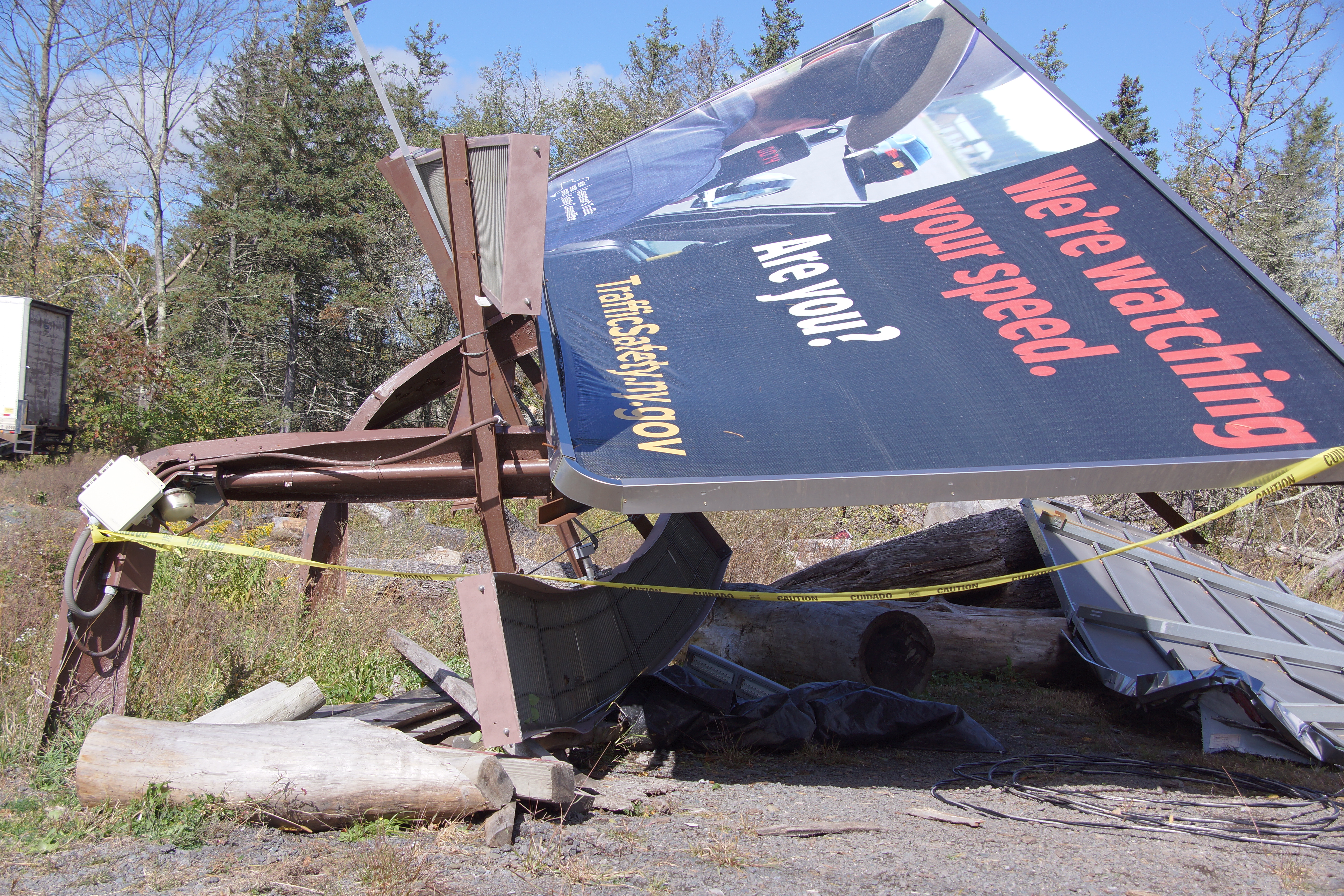
Billboard Bent Over Due to Strong Winds in Johnsville, NY (NWS Storm Survey) |
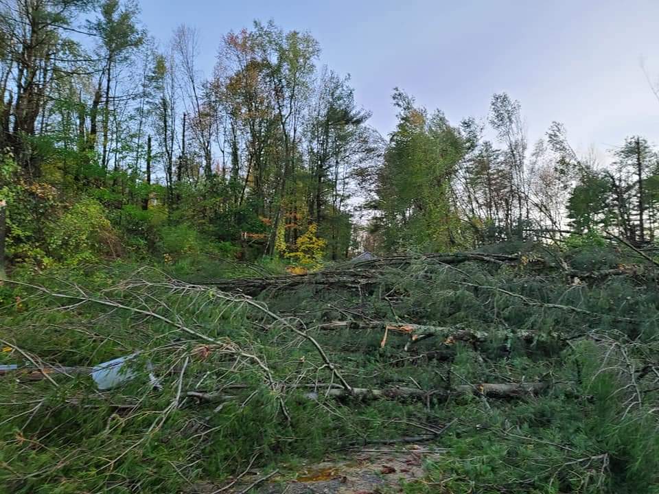
Tree uprooted and toppled over in Pittstown, NY (NWS Storm Survey) |
Multiple trees knocked down in a uniform direction due to straight line wind damage in Schaghticoke, NY (NWS Storm Survey) |
Radar
Storm Reports
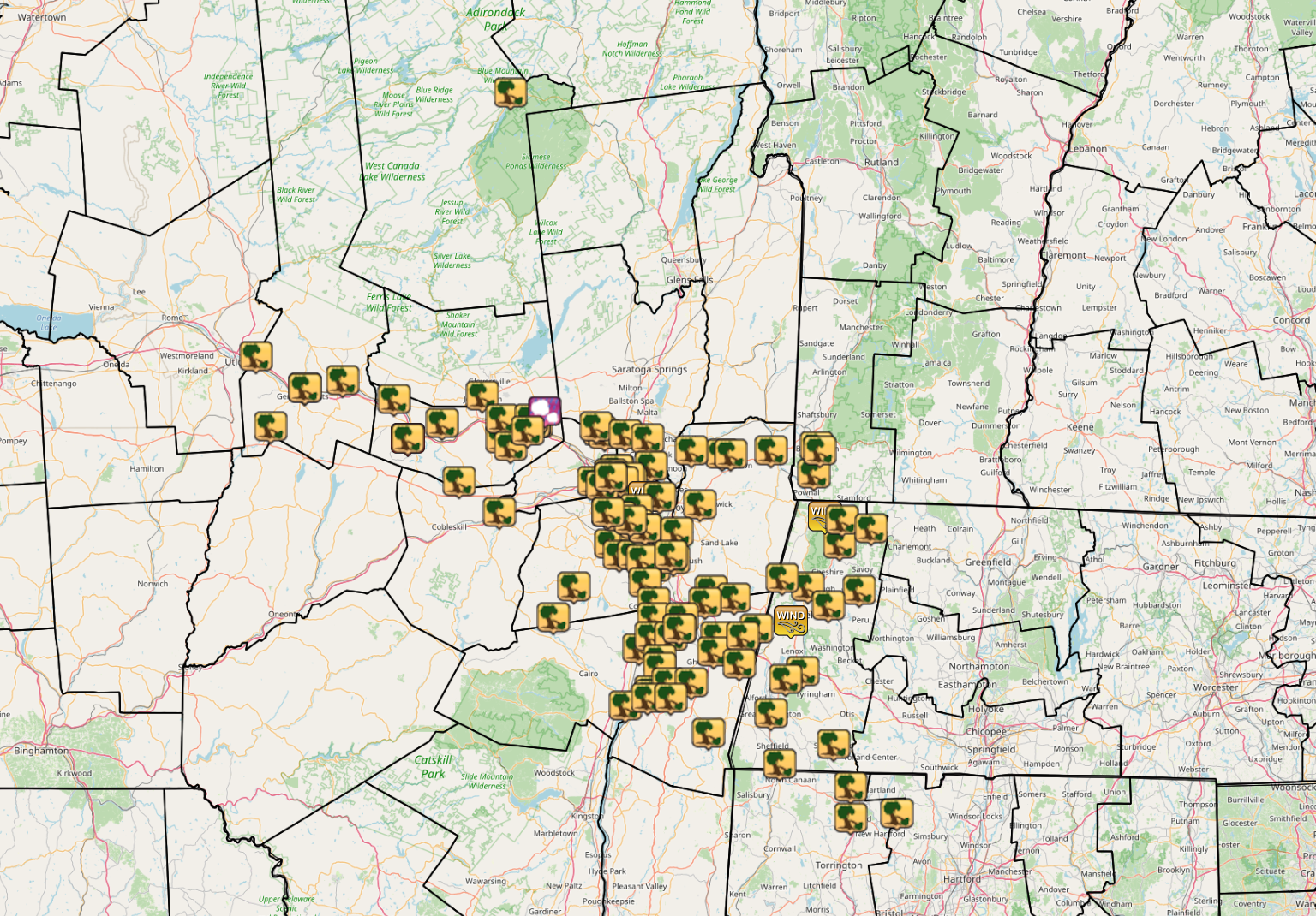
Storm Reports across the NWS Albany County Warning Area from October 7, 2020 (Map above courtesy of Iowa Environmental Mesonet).
PRELIMINARY LOCAL STORM REPORT...SUMMARY
NATIONAL WEATHER SERVICE ALBANY NY
649 PM EDT THU OCT 08 2020
..TIME... ...EVENT... ...CITY LOCATION... ...LAT.LON...
..DATE... ....MAG.... ..COUNTY LOCATION..ST.. ...SOURCE....
..REMARKS..
0244 PM TSTM WND DMG INDIAN LAKE 43.78N 74.27W
10/07/2020 HAMILTON NY DEPT OF HIGHWAYS
DOWN UTLITY POLES AND WIRES BLOCKING ROUTE 30
0244 PM TSTM WND DMG 3 W SCHUYLER 43.11N 75.16W
10/07/2020 HERKIMER NY TRAINED SPOTTER
TREE ON A TRAILER
0255 PM TSTM WND DMG HERKIMER 43.03N 74.99W
10/07/2020 HERKIMER NY PUBLIC
MULTIPLE TREES DOWN
0255 PM TSTM WND DMG HERKIMER 43.03N 74.99W
10/07/2020 HERKIMER NY TRAINED SPOTTER
TREE AND WIRES DOWN
0259 PM TSTM WND DMG LITTLE FALLS 43.05N 74.86W
10/07/2020 HERKIMER NY PUBLIC
MULTIPLE TREES DOWN IN LITTLE FALLS
0259 PM TSTM WND DMG 5 NE WEST WINFIELD 42.93N 75.11W
10/07/2020 HERKIMER NY PUBLIC
TREE ON A HOUSE IN CEDARVILLE
0305 PM TSTM WND DMG ST. JOHNSVILLE 43.00N 74.68W
10/07/2020 MONTGOMERY NY TRAINED SPOTTER
MULTIPLE TREES DOWN ALONG ROUTE 5 IN NORTHERM
MONTGOMERY COUNTY.
0314 PM TORNADO 2 S FORT PLAIN 42.90N 74.63W
10/07/2020 MONTGOMERY NY NWS EMPLOYEE
THE STORM SURVEY TEAM OBSERVED A NEARLY DESTROYED BARN
WITH METAL SIDING STREWN ABOUT THE PROPERTY. A TREE WAS
ALSO TOPPLED. THIS WAS THE ONLY DAMAGE. THE TORNADO WAS
VERY SHORT-LIVED. IT SPUN UP ON THE QLCS LINE MOVING
THROUGH THE AREA.
0315 PM TSTM WND DMG JOHNSTOWN 43.01N 74.37W
10/07/2020 FULTON NY SOCIAL MEDIA
TREE DOWN
0315 PM TSTM WND DMG 3 N SPRAKERS 42.94N 74.51W
10/07/2020 MONTGOMERY NY DEPT OF HIGHWAYS
RTE 10 CLOSED BETWEEN HICKORY HILL RD AND DILLENBECK RD
DUE TO DOWNED POWER POLE AND WIRES.
0317 PM TSTM WND DMG 2 S FORT PLAIN 42.90N 74.63W
10/07/2020 MONTGOMERY NY EMERGENCY MNGR
BARN DAMAGED WITH DEBRIS CARRIED A FEW HUNDRED YARDS
AWAY
0320 PM TSTM WND DMG TRIBES HILL 42.95N 74.30W
10/07/2020 MONTGOMERY NY TRAINED SPOTTER
MULTIPLE LARGE BRANCHES DOWN NEAR TRIBES HILL AND SOME
SIDING RIPPED OFF OF A HOUSE.
0320 PM TSTM WND DMG 5 SE FONDA 42.90N 74.30W
10/07/2020 MONTGOMERY NY TRAINED SPOTTER
NUMEROUS TREES DOWN WITH SOME SNAPS IN THE HAMLET OF
AURIESVILLE.
0324 PM TSTM WND DMG 1 ESE AMSTERDAM 42.94N 74.18W
10/07/2020 MONTGOMERY NY SOCIAL MEDIA
TREES DOWN ON REID HILL
0324 PM TSTM WND DMG 3 WSW CHARLESTON FOUR C 42.79N 74.45W
10/07/2020 MONTGOMERY NY NWS EMPLOYEE
THE STORM SURVEY TEAM OBSERVED SEVERAL HARDWOOD AND
SOFTWOOD TREES UPROOTED IN THE AREA. THE ORIENTATION OF
THE TREES WAS CONSISTENT WITH A STRAIGHT-LINE WIND
MICROBURST. DAMAGE WAS CONFINED TO THE TREES.
0325 PM TSTM WND DMG AMSTERDAM 42.94N 74.19W
10/07/2020 MONTGOMERY NY TRAINED SPOTTER
MANY TREES AND LARGE BRANCHES DOWN ACROSS AMSTERDAM.
0325 PM TSTM WND DMG AMSTERDAM 42.94N 74.19W
10/07/2020 MONTGOMERY NY TRAINED SPOTTER
MULTIPLE TREES SNAPPED AND LARGE BRANCHES DOWN
THROUGHOUT SHUTTLEWORTH PARK IN AMSTERDAM.
0325 PM TSTM WND DMG AMSTERDAM 42.94N 74.19W
10/07/2020 MONTGOMERY NY PUBLIC
TREE ON POWER LINES AT INTERSECTION OF CHARLES LN. AND
SANFORD AVE. TIME ESTIMATED.
0328 PM HAIL HAGAMAN 42.97N 74.15W
10/07/2020 M0.75 INCH MONTGOMERY NY SOCIAL MEDIA
0328 PM TSTM WND DMG 1 WNW AMSTERDAM 42.95N 74.20W
10/07/2020 MONTGOMERY NY TRAINED SPOTTER
TREE PARTIALLY FELL ON A HOUSE NEAR THE INTERSECTION OF
GUY PARK AVENUE AND NORTHAMPTON ROAD.
0330 PM TSTM WND DMG 2 SW AMSTERDAM 42.92N 74.21W
10/07/2020 MONTGOMERY NY DEPT OF HIGHWAYS
ALL LANES BLOCKED ON ROUTE 30 BETWEEN HARTLEY AND
BELLDONS ROAD DUE TO DOWNED TREES AND WIRES.
0330 PM TSTM WND DMG 1 SE WELLSVILLE 42.88N 74.27W
10/07/2020 MONTGOMERY NY PUBLIC
TREE UPROOTED NEAR YOUNGS CORNER RD. AND MILL PT. RD.
TIME ESTIMATED.
0334 PM TSTM WND DMG 1 SE CHARLTON 42.92N 73.96W
10/07/2020 SARATOGA NY PUBLIC
LARGE TREES DOWN
0335 PM TSTM WND DMG CHARLTON 42.93N 73.97W
10/07/2020 SARATOGA NY PUBLIC
NUMEROUS TREES DOWN IN CHARLTON.
0335 PM TSTM WND DMG 1 E CENTRAL BRIDGE 42.71N 74.31W
10/07/2020 SCHOHARIE NY SOCIAL MEDIA
TREES DOWN ON WIRES ALONG ROUTE 7 BETWEEN ROUTE 30 AND
ZICHA RD
0335 PM TSTM WND DMG 2 SE CHARLTON 42.91N 73.94W
10/07/2020 SARATOGA NY TRAINED SPOTTER
TREES ON MULTIPLE HOUSES ON IMPERIAL LA AND REDWOOD DR.
0335 PM TSTM WND DMG 2 WNW ROTTERDAM 42.79N 73.98W
10/07/2020 SCHENECTADY NY DEPT OF HIGHWAYS
ROUTE 337 BETWEEN ROUTE 159 AND PRINCETOWN ROAD CLOSED
DUE TO A DOWNED POLE AND WIRES.
0340 PM TSTM WND DMG NISKAYUNA 42.82N 73.90W
10/07/2020 SCHENECTADY NY TRAINED SPOTTER
NUMEROUS TREES AND LARGE BRANCHES DOWN.
0340 PM TSTM WND DMG BALLSTON LAKE 42.91N 73.87W
10/07/2020 SARATOGA NY METEOROLOGIST
MULTIPLE TREES DOWN BALLSTON LAKE
0342 PM TSTM WND DMG 2 ESE JONESVILLE 42.90N 73.79W
10/07/2020 SARATOGA NY EMERGENCY MNGR
*** 1 FATAL *** PINE TREE FELL ON A CAR AND RESULTED IN
A FATALITY
0343 PM TSTM WND DMG 2 SE CLIFTON PARK 42.83N 73.78W
10/07/2020 SARATOGA NY SOCIAL MEDIA
TREE AND WIRES DOWN IN CLIFTON PARK CENTER
0343 PM TSTM WND DMG 2 SE HAWTHORNE HILL 42.79N 73.85W
10/07/2020 SCHENECTADY NY TRAINED SPOTTER
TREES DOWN ON ROSENDALE RD
0344 PM TSTM WND DMG 1 N NISKAYUNA 42.82N 73.90W
10/07/2020 SCHENECTADY NY NWS EMPLOYEE
LARGE TREE DOWN ON BARCLAY PLACE AND DEAN STREET
0345 PM TSTM WND DMG SCHENECTADY-GE PLOT 42.81N 73.92W
10/07/2020 SCHENECTADY NY NWS EMPLOYEE
LARGE TREE FELL NEAR GE PLOT
0346 PM TSTM WND DMG 1 SW HAWTHORNE HILL 42.79N 73.89W
10/07/2020 SCHENECTADY NY METEOROLOGIST
TREE DOWN ACROSS BALLTOWN ROAD NEAR BENTLEY ROAD
0346 PM TSTM WND DMG 1 ESE HAWTHORNE HILL 42.80N 73.86W
10/07/2020 SCHENECTADY NY SOCIAL MEDIA
LARGE TREE DOWN NEAR LOCK 7
0347 PM TSTM WND DMG 1 S HAWTHORNE HILL 42.79N 73.88W
10/07/2020 SCHENECTADY NY METEOROLOGIST
TREE DOWN ON ROSENDALE ROAD NEAR MAYFIELD ROAD BLOCKING
ONE LANE
0348 PM TSTM WND DMG ROTTERDAM 42.78N 73.95W
10/07/2020 SCHENECTADY NY AMATEUR RADIO
TREES HANGING ON POWER LINES AND TREES DOWN
0348 PM TSTM WND DMG 1 SE SCHENECTADY 42.80N 73.92W
10/07/2020 SCHENECTADY NY AMATEUR RADIO
TREES ON A HOUSE AND POWER LINES IN SCHENECTADY
0350 PM TSTM WND DMG 2 WNW GUILDERLAND 42.71N 73.93W
10/07/2020 ALBANY NY AMATEUR RADIO
MULTIPLE TREES DOWN NEAR CARMEN ROAD IN GUILDERLAND
0352 PM TSTM WND GST ALBANY INTL AP 42.75N 73.80W
10/07/2020 M68 MPH ALBANY NY ASOS
0353 PM TSTM WND DMG LATHAM 42.75N 73.75W
10/07/2020 ALBANY NY PUBLIC
TREES DOWN NEAR MAXWELL DR. AND ASHLEY DR. TIME
ESTIMATED.
0354 PM TSTM WND DMG COLONIE 42.72N 73.83W
10/07/2020 ALBANY NY SOCIAL MEDIA
MULTIPLE TREES DOWN ON FENCES NEAR BRICK LANE IN
COLONIE
0354 PM TSTM WND DMG 1 SE PITTSTOWN 42.86N 73.53W
10/07/2020 RENSSELAER NY NWS EMPLOYEE
A MICROBURST ALONG CROLL ROAD, EAST OF TOMHANNOCK
RESERVOIR IN PITTSTOWN,PRODUCED SIGNIFICANT DAMAGE ON
OCT 7, 2020. THE MICROBURST MOVED IN A GENERAL WEST
SOUTHWEST TO EAST NORTHEAST DIRECTION. MOST OF THE
DAMAGE WAS TO TREES. DAMAGE INCLUDED NUMEROUS SOFTWOOD
TREES SHEARED OFF, A FEW HARDWOOD AND SOFTWOOD TREES
UPROOTED AND SOME MINOR DIRECT STRUCTURAL DAMAGE TO
HOMES INCLUDING SHINGLES BUCKLED UP FROM ONE HOME AND
FLASHING PEELED AWAY FROM ANOTHER HOME.
0355 PM TSTM WND DMG 1 SSE VOORHEESVILLE 42.63N 73.92W
10/07/2020 ALBANY NY DEPT OF HIGHWAYS
ROUTE 85 BETWEEN BULLOCK RD AND SWIFT RD CLOSED DUE TO
DOWNED TREES AND WIRES
0356 PM TSTM WND DMG 3 ESE PITTSTOWN 42.86N 73.50W
10/07/2020 RENSSELAER NY TRAINED SPOTTER
TREE DOWN NEAR CROLL ROAD AND COUNTY ROUTE 111
0356 PM TSTM WND DMG 3 SE MECHANICVILLE 42.87N 73.64W
10/07/2020 RENSSELAER NY SOCIAL MEDIA
DOWNED TREE AND LARGE BRANCHES SNAPPED
0358 PM TSTM WND DMG 2 W ALBANY 42.66N 73.81W
10/07/2020 ALBANY NY PUBLIC
TREE DOWN ON A CAR. WINDSHIELD BROKEN.
0359 PM TSTM WND DMG 2 ESE SYCAWAY 42.73N 73.61W
10/07/2020 RENSSELAER NY TRAINED SPOTTER
TREES DOWN.
0400 PM TSTM WND DMG GUILDERLAND 42.70N 73.89W
10/07/2020 ALBANY NY METEOROLOGIST
40 FOOT WILLOW TREE FELL IN GUILDERLAND.
0400 PM TSTM WND DMG 2 N DELMAR 42.65N 73.83W
10/07/2020 ALBANY NY SOCIAL MEDIA
MUTIPLE TREES DOWN NEAR THE INTERSECTION OF NEW
SCOTLAND AVENUE AND HARTMAN ROAD
0400 PM TSTM WND DMG 2 NNW FEURA BUSH 42.60N 73.89W
10/07/2020 ALBANY NY DEPT OF HIGHWAYS
ROUTE 443 BETWEEN MEADS LANE AND BETHLEHEM TOWN LINE
CLOSED DUE TO DOWNED TREES AND WIRES
0400 PM TSTM WND DMG 2 S DELMAR 42.60N 73.84W
10/07/2020 ALBANY NY PUBLIC
LARGE TREES UPROOTED
0401 PM TSTM WND DMG 2 E WESTMERE 42.68N 73.83W
10/07/2020 ALBANY NY SOCIAL MEDIA
DOWNED TREES ON THE UALBANY CAMPUS
0402 PM TSTM WND DMG 2 S HOOSICK FALLS 42.87N 73.36W
10/07/2020 RENSSELAER NY DEPT OF HIGHWAYS
ROUTE 22 AT HOOSICK FALLS HIGH SCHOOL CLOSED DUE TO
DOWNED TREES AND WIRES
0403 PM TSTM WND DMG 1 W COXSACKIE 42.36N 73.82W
10/07/2020 GREENE NY PUBLIC
TREE DOWN
0404 PM TSTM WND DMG 1 WNW ALBANY 42.67N 73.80W
10/07/2020 ALBANY NY NWS EMPLOYEE
TREES AND WIRES DOWN
0404 PM TSTM WND DMG 1 WNW ALBANY 42.67N 73.80W
10/07/2020 ALBANY NY METEOROLOGIST
LARGE TREE DOWN ON A HOUSE
0405 PM TSTM WND DMG EAST GREENBUSH 42.59N 73.70W
10/07/2020 RENSSELAER NY FIRE DEPT/RESCUE
NUMEROUS REPORTS OF TREES DOWN WITH POWER OUTAGES
THROUGHOUT EAST GREENBUSH.
0405 PM TSTM WND DMG NORTH GREENBUSH 42.66N 73.69W
10/07/2020 RENSSELAER NY METEOROLOGIST
LARGE TREE BRANCHES DOWN
0405 PM TSTM WND DMG 2 NNW CASTLETON-ON-HUDS 42.57N 73.77W
10/07/2020 ALBANY NY DEPT OF HIGHWAYS
ROUTE 144 CLOSED BETWEEN WEMPLE RD AND CLAPPER RD DUE
TO DOWNED POLES AND WIRES
0406 PM TSTM WND DMG 1 E WESTMERE 42.69N 73.85W
10/07/2020 ALBANY NY PUBLIC
LARGE TREE DOWN NEAR CROSSGATES MALL
0406 PM TSTM WND DMG WESTERLO 42.52N 74.05W
10/07/2020 ALBANY NY SOCIAL MEDIA
TREE DOWN ON CAR
0410 PM TSTM WND DMG SELKIRK 42.53N 73.80W
10/07/2020 ALBANY NY TRAINED SPOTTER
NUMEROUS LARGE BRANCHES WITH POWER OUTAGES IN SELKIRK.
0410 PM TSTM WND DMG MEDUSA 42.44N 74.12W
10/07/2020 ALBANY NY SOCIAL MEDIA
SEVERAL TREES DOWN
0410 PM TSTM WND DMG 3 NNE POWNAL 42.81N 73.21W
10/07/2020 BENNINGTON VT DEPT OF HIGHWAYS
TREES AND WIRES DOWN ON ROUTE 7 BETWEEN JACKSON CROSS
ROAD AND CENTER SREET
0410 PM TSTM WND DMG 1 NW BENNINGTON 42.88N 73.20W
10/07/2020 BENNINGTON VT PUBLIC
TREES DOWN
0410 PM TSTM WND DMG 3 N SELKIRK 42.57N 73.80W
10/07/2020 ALBANY NY NWS EMPLOYEE
TREE DOWN BLOCKING ROUTE 9W. TIME ESTIMATED BY RADAR.
0410 PM TSTM WND DMG 3 SSE DELMAR 42.59N 73.81W
10/07/2020 ALBANY NY NWS EMPLOYEE
TREES AND POWER LINES DOWN ON WEMPLE ROAD. TIME
ESTIMATED BY RADAR.
0413 PM TSTM WND DMG 1 NNW EAST GREENBUSH 42.60N 73.71W
10/07/2020 RENSSELAER NY SOCIAL MEDIA
LARGE TREE DOWN ON A CAR
0415 PM TSTM WND DMG BENNINGTON 42.87N 73.19W
10/07/2020 BENNINGTON VT BROADCAST MEDIA
WIDEPSREAD DOWNED TREES AND POWER LINES
0416 PM TSTM WND DMG ADAMS 42.63N 73.12W
10/07/2020 BERKSHIRE MA AMATEUR RADIO
TREE DOWN ON CAR
0416 PM TSTM WND DMG 2 E RAVENA 42.48N 73.77W
10/07/2020 RENSSELAER NY DEPT OF HIGHWAYS
ROUTE 9J BETWEEN COUNTY ROUTE 2 AND COLUMBIA COUNTY
LINE CLOSED DUE TO DOWNED TREES AND WIRES
0417 PM TSTM WND DMG 2 E NASSAU 42.51N 73.57W
10/07/2020 RENSSELAER NY DEPT OF HIGHWAYS
NUMEROUS DOWNED POLES/WIRES ALONG RTE 20 BETWEEN NASSAU
AND RTE 66.
0417 PM TSTM WND GST HARRIMAN-AND-WEST-AI 42.70N 73.17W
10/07/2020 M60 MPH BERKSHIRE MA ASOS
0421 PM TSTM WND DMG NORTH ADAMS 42.69N 73.11W
10/07/2020 BERKSHIRE MA 911 CALL CENTER
MULTIPLE TREES DOWN
0421 PM TSTM WND DMG 5 SSW STEPHENTOWN 42.49N 73.49W
10/07/2020 COLUMBIA NY 911 CALL CENTER
TREE AND WIRES DOWN.
0421 PM TSTM WND DMG 3 NE CHATHAM 42.39N 73.55W
10/07/2020 COLUMBIA NY 911 CALL CENTER
TREE ON WIRES
0422 PM TSTM WND DMG 2 SSE NASSAU 42.48N 73.59W
10/07/2020 COLUMBIA NY 911 CALL CENTER
TREE AND WIRES DOWN.
0422 PM TSTM WND DMG 1 ENE NEW BALTIMORE 42.44N 73.77W
10/07/2020 COLUMBIA NY 911 CALL CENTER
TREE AND WIRES DOWN
0425 PM TSTM WND DMG 4 NW DALTON 42.52N 73.23W
10/07/2020 BERKSHIRE MA AMATEUR RADIO
TREE DOWN IN LANESBORO NEAR ROUTE 8
0425 PM TSTM WND DMG FLORIDA 42.67N 73.01W
10/07/2020 BERKSHIRE MA 911 CALL CENTER
MULTIPLE TREES DOWN
0427 PM TSTM WND DMG 1 W NIVERVILLE 42.44N 73.67W
10/07/2020 COLUMBIA NY 911 CALL CENTER
TREE AND WIRES DOWN
0427 PM TSTM WND DMG STUYVESANT 42.39N 73.78W
10/07/2020 COLUMBIA NY 911 CALL CENTER
TREE AND WIRES DOWN
0427 PM TSTM WND DMG VALATIE 42.41N 73.68W
10/07/2020 COLUMBIA NY 911 CALL CENTER
TREE, WIRES AND POLE DOWN
0428 PM TSTM WND DMG KINDERHOOK 42.39N 73.71W
10/07/2020 COLUMBIA NY 911 CALL CENTER
TREE AND WIRES DOWN
0428 PM TSTM WND DMG VALATIE 42.41N 73.68W
10/07/2020 COLUMBIA NY 911 CALL CENTER
TREE AND WIRES DOWN ON VEHICLE
0430 PM TSTM WND DMG 3 N STOTTVILLE 42.33N 73.75W
10/07/2020 COLUMBIA NY 911 CALL CENTER
TREE THROUGH HOUSE
0431 PM TSTM WND DMG HANCOCK 42.54N 73.32W
10/07/2020 BERKSHIRE MA 911 CALL CENTER
MULTIPLE TREES DOWN
0433 PM TSTM WND DMG WINDSOR 42.51N 73.05W
10/07/2020 BERKSHIRE MA AMATEUR RADIO
TREE AND WIRES DOWN ON ROUTE 9 AT THE INTERSECTION OF
HILL STREET AND HILL ROAD
0433 PM TSTM WND GST PITTSFIELD MUNICIPAL AP 42.43N 73.29W
10/07/2020 M60 MPH BERKSHIRE MA ASOS
0434 PM TSTM WND DMG DALTON 42.47N 73.16W
10/07/2020 BERKSHIRE MA SOCIAL MEDIA
LARGE TREE LIMB DOWN
0434 PM TSTM WND DMG 2 NNE STOTTVILLE 42.31N 73.75W
10/07/2020 COLUMBIA NY 911 CALL CENTER
TREE AND WIRES DOWN
0436 PM TSTM WND DMG 2 E CANAAN 42.41N 73.41W
10/07/2020 COLUMBIA NY 911 CALL CENTER
POLE SNAPPED
0437 PM TSTM WND DMG 2 SSW CANAAN 42.39N 73.46W
10/07/2020 COLUMBIA NY 911 CALL CENTER
TREE AND WIRES DOWN
0437 PM TSTM WND DMG 2 ESE CHATHAM 42.35N 73.56W
10/07/2020 COLUMBIA NY 911 CALL CENTER
TREE ON WIRES
0438 PM TSTM WND DMG HUDSON 42.25N 73.78W
10/07/2020 COLUMBIA NY 911 CALL CENTER
POLE SNAPPED AND WIRES DOWN
0439 PM TSTM WND DMG 2 SE STOTTVILLE 42.27N 73.72W
10/07/2020 COLUMBIA NY DEPT OF HIGHWAYS
DOWNED WIRES RESULTED IN ROAD CLOSURE ON RTE 66 AT RTE
9H.
0439 PM TSTM WND DMG 1 SSE HUDSON 42.24N 73.78W
10/07/2020 COLUMBIA NY 911 CALL CENTER
TREE ON WIRES
0440 PM TSTM WND DMG CATSKILL 42.21N 73.87W
10/07/2020 GREENE NY TRAINED SPOTTER
TREE ON A HOUSE WITH A PARTIAL STRUCTURAL COLLAPSE
REPORTED IN THE VILLAGE OF CATSKILL.
0440 PM TSTM WND DMG 1 NNE PHILMONT 42.27N 73.64W
10/07/2020 COLUMBIA NY 911 CALL CENTER
TREE ON WIRES
0442 PM TSTM WND DMG 2 S HUDSON 42.23N 73.79W
10/07/2020 COLUMBIA NY 911 CALL CENTER
POLE BROKEN WITH WIRES DOWN
0443 PM TSTM WND DMG 1 ENE CLAVERACK 42.23N 73.71W
10/07/2020 COLUMBIA NY 911 CALL CENTER
TREE ON POWER LINES
0444 PM TSTM WND DMG AUSTERLITZ 42.32N 73.47W
10/07/2020 COLUMBIA NY SOCIAL MEDIA
TREE DOWN ON COUNTY ROUTE 9
0448 PM TSTM WND DMG LEE 42.30N 73.25W
10/07/2020 BERKSHIRE MA 911 CALL CENTER
PARTS OF ROUTE 20 CLOSED IN LEE DUE TO DOWNED TREES
0448 PM TSTM WND DMG STOCKBRIDGE 42.28N 73.31W
10/07/2020 BERKSHIRE MA 911 CALL CENTER
MULTIPLE DOWNED TREES
0454 PM TSTM WND DMG 3 NNW COPAKE 42.14N 73.58W
10/07/2020 COLUMBIA NY 911 CALL CENTER
TREE ON WIRES
0455 PM TSTM WND DMG GREAT BARRINGTON 42.19N 73.36W
10/07/2020 BERKSHIRE MA BROADCAST MEDIA
*** 1 FATAL *** TREES DOWN ON MAN IN GOLF CART ON
WYANTENUCK GOLF COURSE. TIME ESTIMATED.
0516 PM TSTM WND DMG SANDISFIELD 42.11N 73.14W
10/07/2020 BERKSHIRE MA 911 CALL CENTER
DOWNED TREE
0520 PM TSTM WND DMG ASHLEY FALLS 42.06N 73.33W
10/07/2020 BERKSHIRE MA 911 CALL CENTER
DOWNED TREES AND WIRES
0524 PM TSTM WND DMG COLEBROOK 42.00N 73.08W
10/07/2020 LITCHFIELD CT 911 CALL CENTER
DOWNED TREES
0528 PM TSTM WND DMG 1 SW WINSTED 41.92N 73.08W
10/07/2020 LITCHFIELD CT EMERGENCY MNGR
TREE DOWN
0529 PM TSTM WND DMG 4 NE NEW HARTFORD 41.93N 72.92W
10/07/2020 LITCHFIELD CT 911 CALL CENTER
DOWNED TREES
Environment
 |
 |
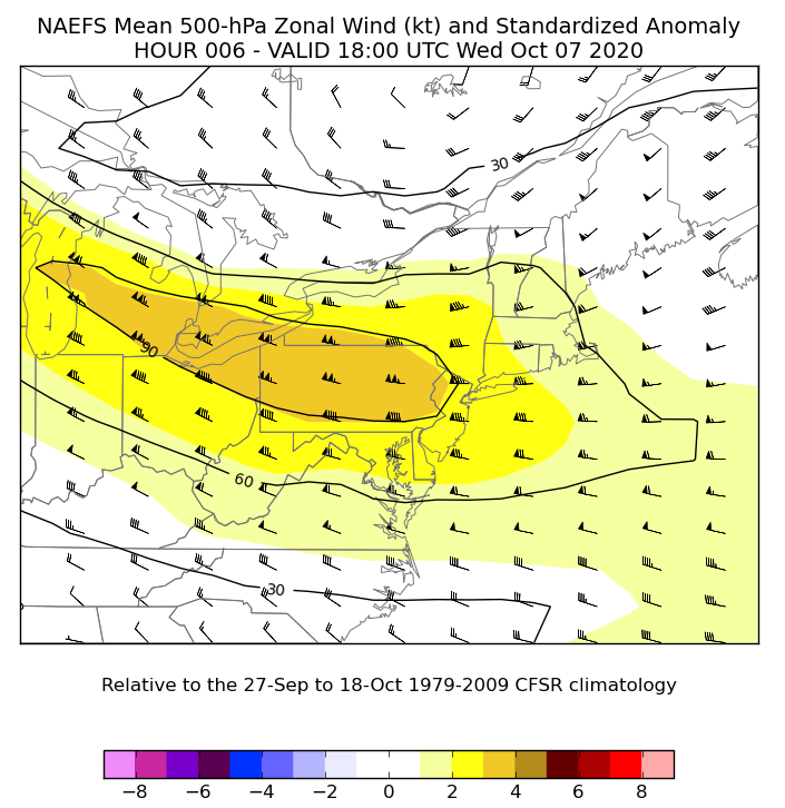 |
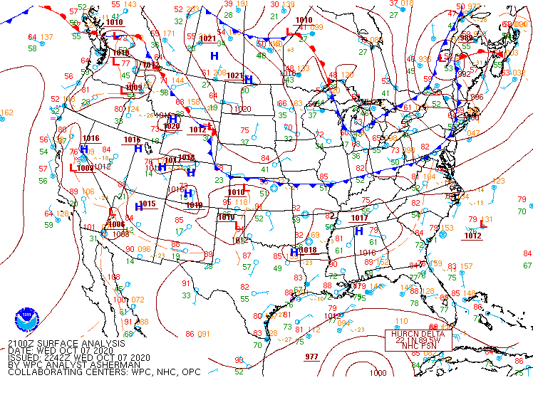
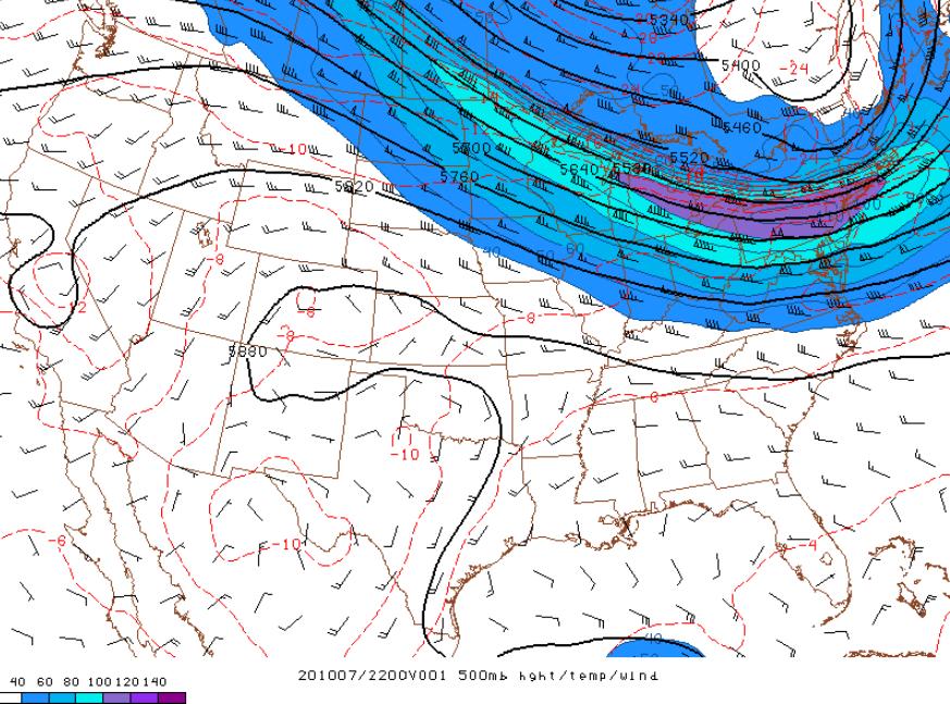
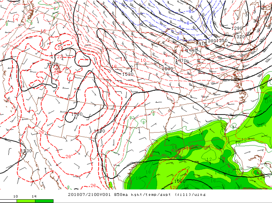
| Figure 1: Surface Map Valid 21 UTC (5PM EDT) Wednesday October 7, 2020. | Figure 2: Very strong 70 - 110kt jet at 500mb nosing into the Northeast at 22 UTC (6PM EDT). Parent trough at this time is also becoming negatively tilted | Figure 3: 500hPa U-Wind Anomaly range 3 to 4 standard deviations above normal at 18 UTC 07 October per the NAEFS (North American Ensemble Forecast System). Initialized at 06 UTC 07 October |
Near-storm environment summary.
 |
 |
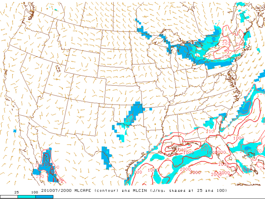 |
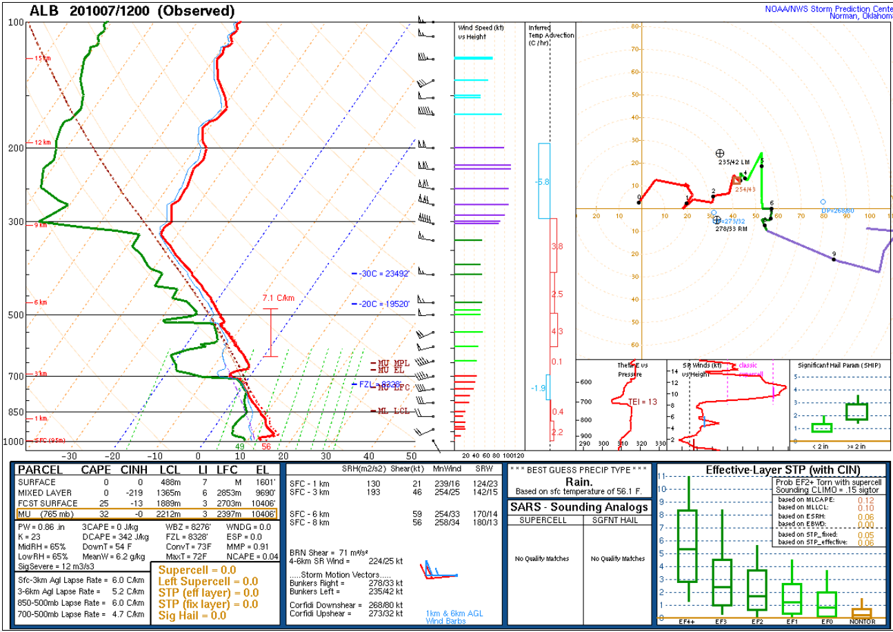
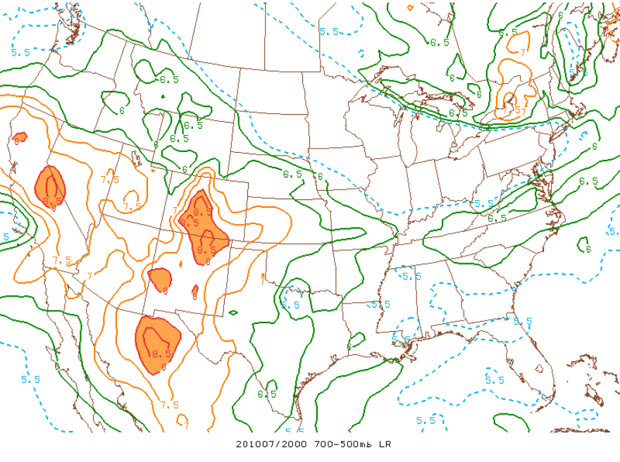
| Figure 4: 12 UTC 07 October Albany, NY Sounding | Figure 5: Steepening Mid-level lapse rates at 20 UTC (4 PM EDT) | Figure 6: Mixed Layer CAPE at 20 UTC (4PM EDT) |
Additional environmental data.
 |
 |
 |
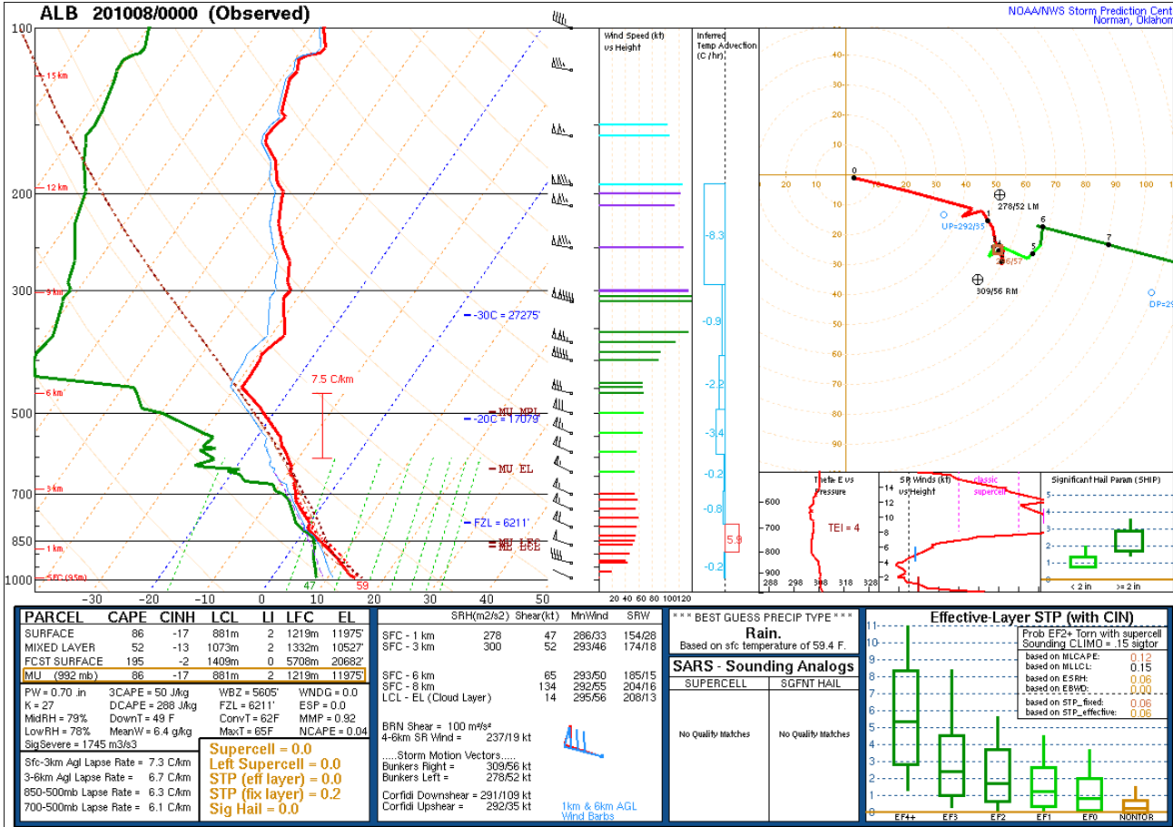
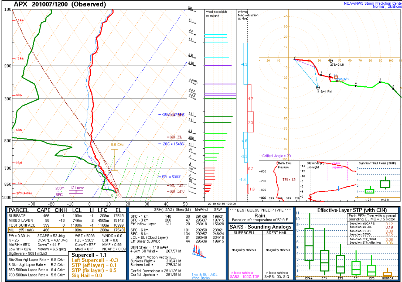
| Figure 7: 00 UTC 08 October Albany, NY Sounding | Figure 8: 12 UTC 07 October Gaylord, MI Sounding | Figure 9: 21 UTC 07 October 850hPa map shows 45 - 50 kt jet directed into eastern NY and western New England |
 |
Media use of NWS Web News Stories is encouraged! Please acknowledge the NWS as the source of any news information accessed from this site. |
|

