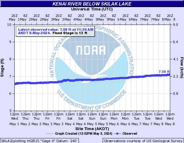
The Skilak Glacier Dammed Lake is located in the Harding Ice Field above the Skilak River. This lake is smaller than the Snow Glacier dammed lake, with an estimated 102,000 acre-ft of water during a recent release. The lake typically releases in the late fall every two years. The release of this lake typically causes a 1-4 foot rise in the Kenai River below Skilak Lake.
| Date | Pool Height | Comments |
|---|---|---|
| 30 August 2016 | 2965 feet | |
| 16 July 2016 | 2950 feet | |
| 27 June 2016 | 2940 feet | |
| 24 September 2015 | 2900 feet | |
| 12 August 2015 | 2870 feet | |
| 18 July 2015 | 2840 feet | |
| 24 September 2013 | Release | An overflight by the civil air patrol confirmed that the Skilak Glacier Dammed Lake released the third week in September. The lake was partially drained on Sep. 24th. Water levels at the gage below Skilak Lake rose almost 2 feet cresting at 13.5 ft on Sep. 27th (minor flood stage is 13.0 ft). Stage levels at Kenai Keys rose less than 2 feet cresting around 11.0 ft on the 27th (minor flood stage is 11.0 ft). The lake water level before release was an estimated 2900 feet in elevation which is approximately 10 feet lower than the previous release in 2011. |
| 9 September 2013 | 2900 feet | |
| 10 August 2013 | 2880 feet | |
| 17 July 2013 | 2865 feet | |
| October 2011 | Release | The Skilak Glacier Dammed Lake released the first week in October. Water levels at the gage below Skilak Lake rose about 2 feet cresting at 12.96 ft on Oct. 12th (minor flood stage is 14.2 ft). Stage levels at Kenai Keys rose just under 2 feet cresting around 10.15 ft on the 12th (minor flood stage is 11.5 ft). The lake water level before release was an estimated 2910 feet in elevation which is approximately 15 feet lower than the previous release in 2009. |
| 26 September 2011 | 2910 feet | |
| 26 August 2011 | 2905 feet | |
| 22 July 2011 | 2890 feet | |
| 20 August 2010 | 2855 feet | |
| 8 August 2009 | Release | Skilak Glacier Dammed Lake began releasing on August 8th 2009 and river stages on the Kenai crested 10 days later on the 17th. An estimated 102,000 acre-ft of water drained from Skilak GDL causing water levels at the gage below Skilak Lake to rise 2.5 ft and crest at 15.0 ft. Water levels downstream of Skilak Lake crested above minor flood stages and minor flooding occurred in the Kenai Keys and Big Eddy areas. Roads and yards were inundated and some garages took on water, but there was no damage to household structures reported. A flight on 8/1/09 confirmed that the lake was still full and had not released. Approximate water level was 2925 feet. The rise on the lower Kenai River during the last two weeks of July 2009 was actually due to rainfall and enhanced glacial melt and not a glacier dammed lake release. |
| 1 August 2009 | 2925 feet | |
| 17 September 2008 | 2910 feet | |
| 8 August 2008 | 2885 feet | |
| 16 January 2007 | Release | The previous release began releasing around the 16th of January 2007. The Kenai River below Skilak Lake experienced a broad crest on the 27th. The rise in water levels initiated breakup of the lower Kenai ice cover causing ice jams and localized flooding in the Soldotna vicinity. It also resulted in the 2nd highest water level on record at the river gage at the Sterling Highway bridge in Soldotna. The highest stage on record occurred in 1969, also a result of ice jams resulting from a release of this lake. |
 |
 |
 |


