National Weather Service United States Department of Commerce

Christmas Day Tornadoes of 2012

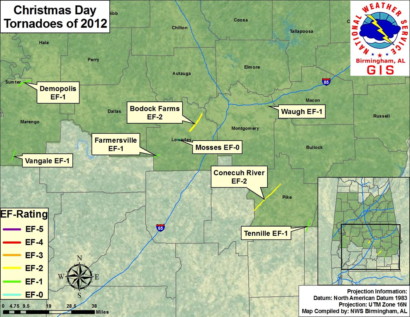
Event Summary for Central Alabama

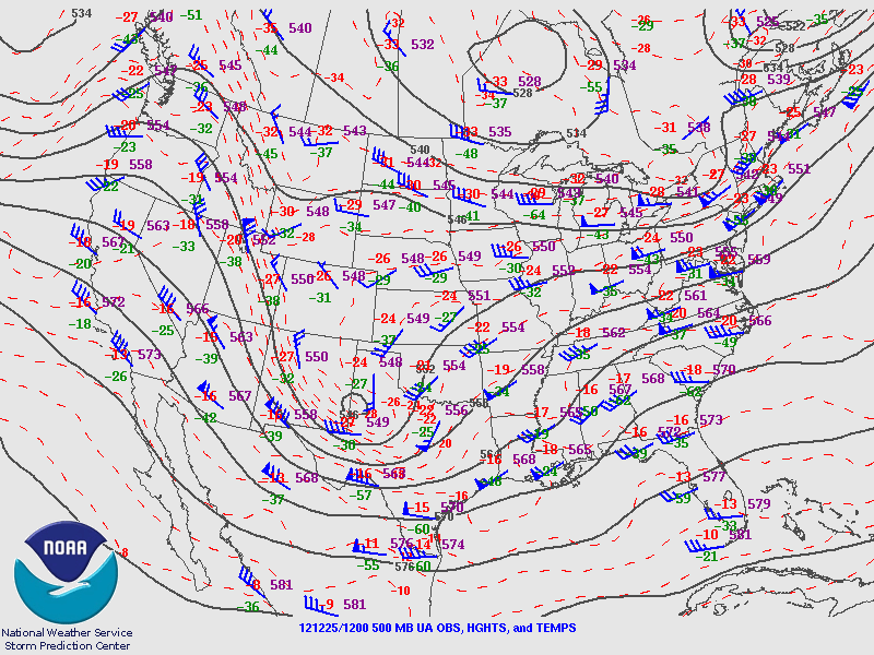
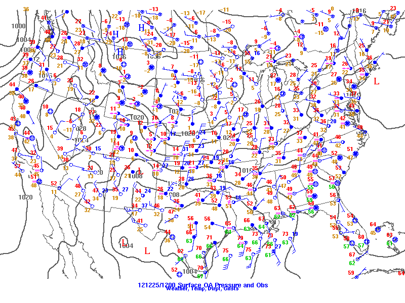
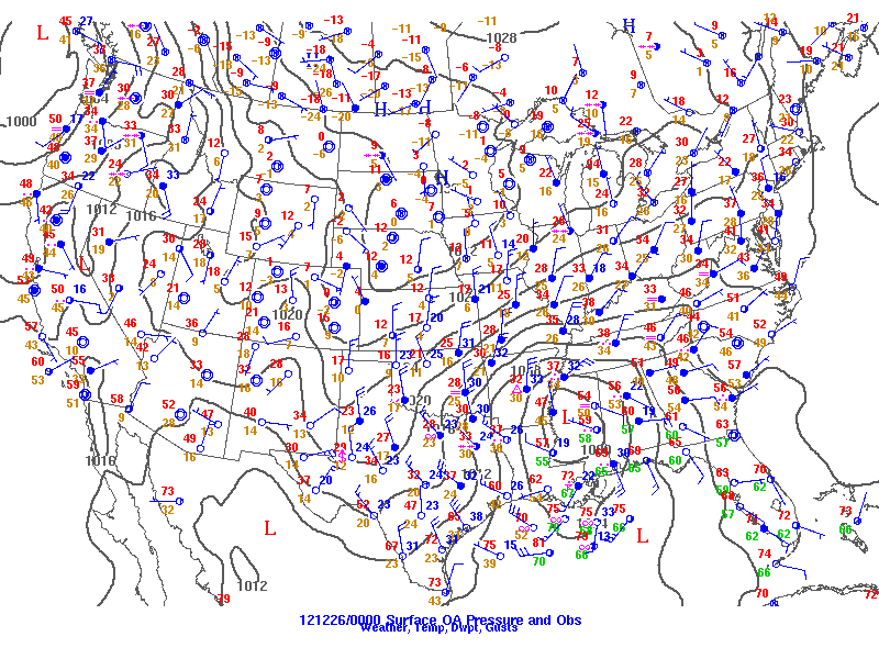
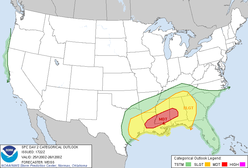
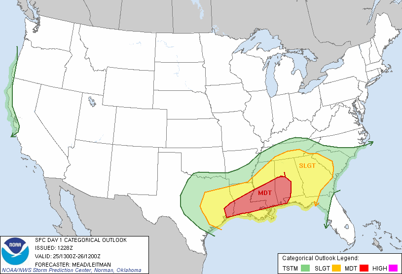
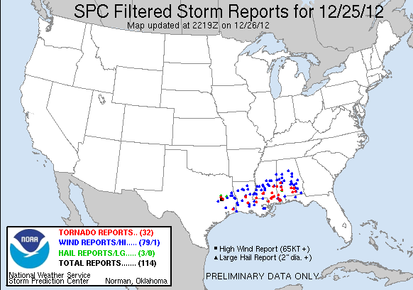
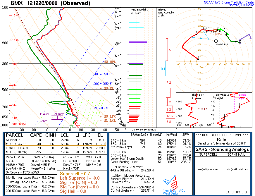
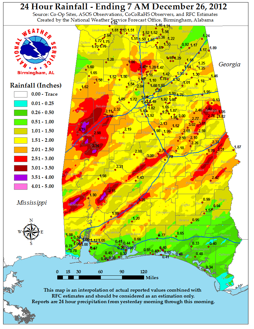
As part of a two day event, with severe weather stretching from Texas to North Carolina and heavy snowfall across the center of the country, Central Alabama experienced a wide range of severe weather on Christmas Day.  Late Christmas Eve, a well amplified upper level trough dug into the southern plains.  In response, a surface low developed Christmas morning over southern Texas.  As the upper low deepened it tilted negatively and helped to deepen the surface low as it moved eastward.  By Christmas afternoon, a swath of severe weather swept across the deep south, with discrete supercells and a broken line of thunderstorms in trail.  These thunderstorms moved across east Texas, Louisiana, and south Mississippi during the afternoon hours, and then into south and central Alabama during the evening hours, bringing with them strong straight line winds, numerous tornadoes, as well as flooding.  The tornado accounts below are specifically for the counties of Central Alabama.

The information below is the PRELIMINARY (subject to change) summaries of tornadoes from this day.

 
Location/Clickable Detailed Summary Link
Damage Rating/Estimated Maximum Wind Speeds
Injuries/Fatalities
Damage Path Length/Width
Starting Point/Time
Ending Point/Time
Vangale
(Marengo County)
EF-1
90 mph
None
4.7 miles
100 yards
32.0238/-87.8687
315 pm
32.0873/-87.8415
321 pm
Tennille
(Pike County)
EF-1
110 mph
None
3.7 miles
300 yards
31.6180/-85.7709
530 pm
31.6664/-85.7473
536 pm
Demopolis
(Marengo County)
EF-1
100 mph
None
5.9 miles
500 yards
32.4762/-87.8228
550 pm
32.5140/-87.7324
559 pm
Farmersville
(Lowndes County)
EF-1
105 mph
None
2 miles
300 yards
32.0513/-86.8505
809 pm
32.0661/-86.8205
809 pm
Mosses
(Lowndes County)
EF-0
75 mph
None
0.6 miles
75 yards
32.1521/-86.6818
826 pm
32.1574/-86.6733
826 pm
Bodock Farms
(Lowndes County)
EF-2
120 mph
None
9.55 miles
900 yards
32.2043/-86.6041
832 pm
32.3133/-86.5115
846 pm
Conecuh River
(Pike County)
EF-2
120 mph
2 Injuries
15.7 miles
600 yards
31.7252/-86.1472
1024 pm
31.8844/-85.9565
1040 pm
Waugh
(Montgomery County)
EF-1
90 mph
None
0.7 miles
100 yards
32.3527/-86.0452
1029 pm
32.3628/-86.0422
1029 pm
 
The tornado damage swaths as depicted in the image above, and on the individual tornado links, are an estimate of the damage widths along the track.  In other words, the track width may not represent the actual damage in all locations, as we interpolate the values between actual surveyed damage points.  These maps are soley for the purpose of showing the general track of each tornado.  Remember, tornadoes do not always move in straight lines, and the intensity does not remain constant.  It is also possible to have other thunderstorm wind-related damage in close proximity to the tornado tracks from such features as inflow and rear flank downdrafts, which can produce tornado-like damage.
          

Pertinent Geographic Information Systems (GIS) Data from this Event


Other affected County Warning Areas

NWS Mobile, AL 

NWS Jackson, MS 


Severe Weather Episode Data 

500 mb Dec 25 at 6 am
500 mb Analysis
  Dec 25 at 6 am 
500 mb Dec 25 at 6 pm
  500 mb Analysis
  Dec 25 at 6 pm
Sfc Analysis Dec 25 at 6 am
Surface Analysis
  Dec 25 at 6 am
Surface Analysis Dec 25 at 6 pm
Surface Analysis
  Dec 25 at 6 pm
Day 2 Outlook 1130 am
Day 2 Severe Weather Outlook
Issued Dec 24 at 1130 am
Day 1 Outlook 7 am
Day 1 Severe Weather Outlook
Issued Dec 25 at 7 am 
Storm Reports for Dec 25
Storm Reports 12/25/12
BMX Sounding Dec 25 at 6 pm
BMX Upper Air Sounding Dec 25 at 6 pm

Rainfall totals for Alabama on Christmas Day
Rainfall Totals for Christmas Day