|
Local Climate of the Treasure Valley and Boise, Idaho
|
| |
| |
|
Location and Topography
|
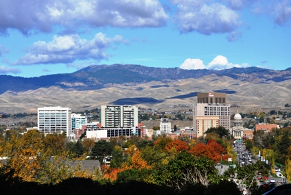
The City of Boise is located in the Treasure Valley which is a part of the larger Snake River Valley of Southern Idaho. The Boise Air Terminal known as Gowen Field is centered at 43 33.86’N Latitude 116 13.37’W Longitude. This is the location of the ASOS (Automated Surface Observation System) at the west end of the field on the approach to runway 10R 28L. Airport elevation is 2871 feet MSL while that of the surrounding city varies from 2500 feet to 2850 feet MSL. The metropolitan area lies in a narrow part of the Lower Snake River Valley, approximately 40 miles wide oriented in a Northwest to Southeast direction. The valley is rimmed by the Boise Mountains to the north and the Owyhee Range to the southwest. The highest peaks in these ranges are 8,000 feet MSL. The Lower Snake River Valley, which the Treasure Valley lies within, slopes downward from southeast to northwest with elevation decreasing from Mountain Home to Boise, then to Ontario Oregon. The elevation difference between these valley endpoints is 850 feet. The Boise River flows through Downtown Boise from east to west continuing through the Treasure Valley to a confluence with the Snake River at the Idaho Oregon State line. The river basin and its reservoir storage areas at Lucky Peak and Arrow Rock Dams are an important source of irrigation water for the area and provide abundant recreation opportunities.
The Cascade and Blue Mountain Ranges in Oregon and Washington modify Pacific Maritime air masses as they move east to the Treasure Valley and the city of Boise. The result is that these air masses are considerably drier once they reach Southwest Idaho. In addition, the Rocky Mountains to the east act as a barrier to cold shallow air masses moving southward from Canada in winter. The effect from all these Mountain ranges is to make Boise and the Treasure Valley semi-arid with relatively mild winters for its northern location. Local sources of surface water are the Boise River meandering through the city and the Snake River 20 miles to the south. Native vegetation consists primarily of sagebrush, sparse desert grasses and other Great Basin Flora. A large variety of native and non-native trees thrive in the Boise River Basin. The Valley and the surrounding agricultural land is heavily dependent on irrigation, with this moisture playing a role in modifying the local climate of the Valley to some extent.
|
| |
|
Local Effects
|
|
WIND DIRECTION:
Wind direction regime of the Treasure Valley and the city of Boise is a direct result of the northwest to southeast orientation of the Treasure Valley and the mountain ranges that border it. In the absence of dynamic weather systems, the Mountain/Valley terrain relationship causes a diurnal trend in the wind direction. Since the valley slopes downward from southeast to northwest, a southeast drainage wind occurs during the night and early morning hours from approximately midnight to mid morning local time. During the afternoon hours, the east end of the valley heats up faster than the west end creating surface low pressure, which in turn creates a northwest wind. This effect is most pronounced during the warm months when heating is intense and more rapid. Deviations to this diurnal trend in wind direction are evident when a strong surface high pressure system is positioned west of the valley. In this case, winds will be northwest until the high pressure system moves east of the city then winds shift southeast. Similarly, deep low pressure systems to the west of Boise or highs to the east have the opposite effect to overcome the diurnal influences. The mountain ranges both to the north and southwest of the valley act to channel winds through the valley in both the northwest and southeast directions. Wind direction other than northwest or southeast is uncommon but they do occur. North to northeast winds from the Boise Mountains occur briefly on hot summer evenings pushing temperatures even higher due to downslope warming. Southwest winds blow occasionally when a large mid-latitude cyclone affects the Pacific Northwest in Winter. Overall wind direction climatology for the Treasure Valley indicates that 85 percent of all wind comes from either the northwest or southeast direction and evenly split between the two directions.
|
| |
|
WIND SPEED:
The Treasure Valley is not a windy location but there are cases when strong or gusty winds do occur. Locations at both ends of the Valley, at Mountain Home and Ontario, are windier due to channeling effects or in the case of northwest flow at Ontario , downsloping from the Blue Mountains in Eastern Oregon which causes Northwest winds to accelerate. Boise is located about midway through the valley and closer to the Boise front range, so these channeling effects are not as pronounced as they are at the endpoints of the valley, thus lighter winds occur at Boise. That is not to say that Boise does not have strong winds at times. They do occur and under varying circumstances. Strong winds at Boise occur in the following situations:
- A cold frontal passage. Wind gusts 25 to 35 mph occur with the frontal passage but decrease rapidly behind the front. The duration usually lasts only a few minutes. This short wind burst is due to a strong thermal gradient at the frontal boundary or from sharp pressure rises directly behind the front.
- Mature non severe thunderstorm cells sending outflow into the Treasure Valley. These gusty outflow winds commonly peak at 35 mph and persist for a short time. However, severe thunderstorms will produce wind gusts much higher, persist longer, and may have damaging effects.
- A strong pressure gradient develops over southwest Idaho . This gradient occurs in one of two ways: First, an intense ridge of high pressure develops over the Rockies and a deep low moves inland from the Pacific Northwest and maintains itself as it crosses the mountains. This results in falling pressures in the local area. If the ridge to the east persists or strengthens, the pressure gradient in the Treasure Valley increases causing local surface winds to blow from the east or southeast with peak gusts as high as 40 to 50 mph. These strong winds may last from 4 to 6 hours. Second, and more frequent, low pressure exists to the east and intense ridging builds over the Pacific Northwest. In this case wind strength depends on the development of the low pressure to the east. A deepening low over northern Utah or western Colorado with cold air after passage of the upper level trough will result in strong west to northwest winds over the area peaking as high as 50 mph and persisting for a couple days. This is a common pattern in the Spring between March and mid May and is the windiest time of the year at Boise and the Treasure Valley. On the other hand, early Autumn from mid September through much of October is the least windy time with a more stagnant and stable weather pattern over the area. Some of the most pleasant weather of the year occurs during this light wind period.
|
| |
|
TEMPERATURE:
Boise and the Treasure Valley have a typical high desert temperature regime. This means that nights cool down quickly and the days heat quickly as well. This is due to the overall dryness to the air and the higher elevation. Mountain barriers block very cold air masses from the east and north and also dry out Pacific air masses from the west. Because Boise lies within the main belt of the westerlies, Maritime Polar air masses dominate the region much of year, but they are considerably modified by the time they reach the local area. This makes Boise temperatures milder in winter for this northern location but also hotter in Summer. Average annual temperature is 5 degrees warmer than cities at the same latitude east of the Rockies.
In summer with southeast surface winds, the east end of the valley heats up faster than the west end. Afternoon maximum temperatures are about 5 degrees F higher than if the winds were northwest during the afternoon. During winter, if an Arctic front makes its way into the Treasure Valley from the north or east, and if snow cover is present, below-zero minimum temperatures may persist for days or even longer, but these are rare events. For example, from 1991 through 2008 a sub zero temperature occurred only once at the Boise Airport. Normally, milder temperatures are common in the Valley in winter often resulting in rain instead of snow. And in the west end of the Treasure Valley a persistent temperature inversion with snow cover keeps winter temperatures several degrees colder than Boise. The all time record high temperature at Boise was 111F degrees set on 19 July 1960 while the record low was 25 degrees below zero set on 22 December 1990. |
| |
|
PRECIPITATION:
The semi-arid climate of Boise produces an average of just over eleven inches of rain and melted snow per year at the airport. The area has a cool season maximum of precipitation while the warm season is mostly dry. The bulk of the annual precipitation is received between November and May with three quarters of the amount. The winter months are characterized by steady widespread precipitation while the warm season months have more spotty convective showers and thunderstorms. Because much of the moisture from wet Pacific air masses is lost when they cross the mountains ranges to our west, Boise has it’s high desert semi-arid climate typical of many areas of the Inland Pacific Northwest or northern Great Basin.
 Boise and the Treasure Valley have a high frequency of night time precipitation in the winter months with 75 percent of the total falling between midnight and 8am local time. This overnight precipitation happens with uncanny regularity and often results in adverse traveling conditions in the early morning hours with roads covered in ice, snow, rain or a combination of all three. Snowfall at Boise averages around 20 inches per year but can vary from a low of only a few inches to 30 to 40 inches. With milder temperatures frequently in the Treasure Valley during the winter, snowfall is not as great as in other mid-latitude locations. In contrast, the surrounding mountains get abundant snowfall in a normal year because of the higher elevation, colder temperatures and the mountain orographic wind flow effects producing these greater amounts of snow. The biggest snows and highest impact winter weather events in the Treasure Valley occur when cold air gets trapped at the surface usually following a protracted inversion event, then warmer moist air overruns the cold shallow surface air producing snow. Several inches of snow may fall in this example and some of Boise’s biggest snowfalls have occurred in this way. In some instances the cold air in the valley is swept out by strong southeast winds which tend to warm and dry the air causing a change to rain or no precipitation at all. Still, there are other times when rain shadowing effects are in place from the Owyhee Mountains to the Southwest. In this case the Valley endpoints at Ontario and Mountain Home receive measurable precipitation while Boise remains dry. Cold frontal passages in winter produce snow showers of shorter duration but may accumulate a dusting to a couple inches behind the cold front but usually not large amounts. Boise and the Treasure Valley have a high frequency of night time precipitation in the winter months with 75 percent of the total falling between midnight and 8am local time. This overnight precipitation happens with uncanny regularity and often results in adverse traveling conditions in the early morning hours with roads covered in ice, snow, rain or a combination of all three. Snowfall at Boise averages around 20 inches per year but can vary from a low of only a few inches to 30 to 40 inches. With milder temperatures frequently in the Treasure Valley during the winter, snowfall is not as great as in other mid-latitude locations. In contrast, the surrounding mountains get abundant snowfall in a normal year because of the higher elevation, colder temperatures and the mountain orographic wind flow effects producing these greater amounts of snow. The biggest snows and highest impact winter weather events in the Treasure Valley occur when cold air gets trapped at the surface usually following a protracted inversion event, then warmer moist air overruns the cold shallow surface air producing snow. Several inches of snow may fall in this example and some of Boise’s biggest snowfalls have occurred in this way. In some instances the cold air in the valley is swept out by strong southeast winds which tend to warm and dry the air causing a change to rain or no precipitation at all. Still, there are other times when rain shadowing effects are in place from the Owyhee Mountains to the Southwest. In this case the Valley endpoints at Ontario and Mountain Home receive measurable precipitation while Boise remains dry. Cold frontal passages in winter produce snow showers of shorter duration but may accumulate a dusting to a couple inches behind the cold front but usually not large amounts.
Freezing Precipitation is a rare event at Boise and the Treasure Valley due to the relative deepness of the Snake River Valley (about 2000 feet). This occurrence generally requires a thin shallow layer of cold air at the surface and warmer air aloft. When it does occur, weather related impacts are much higher than when liquid and frozen precipitation falls. Freezing Rain or Freezing Drizzle is more common in the lower Treasure Valley at Ontario due to the lower elevation and cold air remaining trapped there for a longer time. |
| |
|
FOG…LOW CLOUDS AND INVERSION IMPACTS:
Fog occurrence is primarily limited to the winter months at Boise and the Treasure Valley. This fog is mostly advection fog meaning it moves here from some other place. In Boise dense fog spreads over the city on light West to Northwest flow and usually occurs after a moist air mass has produced measurable rain or snow over the area. If this precipitation is followed closely by a ridge of high pressure with a weak surface gradient, fog forms quickly as moisture gets trapped below the subsidence inversion and is not able to scour away. This situation is most likely if it occurs during the period from Thanksgiving to Valentine’s Day when stagnant high pressure systems usually move over the area and stall. It also coincides with the coldest temperatures of the year and shortest period of daylight. The fog can become locally dense reducing visibility to less than one-quarter mile at the Boise Airport and vicinity. This low condition hampers airport operations as well as traffic on the busy I-84 corridor from Boise to Meridian and west into Canyon County. Cloud seeding operations are common in winter at the airport and may commence when the temperature drops to a critical level. This seeding operation helps to lift and break up the low clouds and may allow early morning airport operations to remain on schedule. In addition, smoke and haze from the many fireplaces in the Treasure Valley along with automobile exhaust is frequently trapped under the inversion layer. These particulates act as excellent condensation nuclei and enhance the production of dense fog and lower air quality in Boise and the Treasure Valley.
The strong inversion events may last several days or even weeks if the weather pattern stagnates. The extensive low clouds and widespread fog when combined with the long hours of winter darkness and cold will enhance the overall gloominess to weather conditions at this time of year. It is during these foggy and low cloud events when valley temperatures may not deviate by more than a few degrees from high to low temperature. The breakup of low cloud and fog in Boise is highly dependent on wind direction and speed, strength of weather systems passing over the area , and time of year.
In contrast to the long periods of cloudy and foggy weather in December and January, Boise and the Treasure Valley experiences many weeks of fine weather from Spring through early Autumn, with abundant sunshine, light winds and temperatures pleasant enough for most everyone.
|


