Mouse over each site to display hydrograph.
Hydrographs (showing stages and flows over time) are available through AHPS (Advanced Hydrologic Prediction Service) by clicking site names.
| No Flood | Near Flood | Minor Flood | Moderate Flood | Major Flood |
| River Conditions at: 9:02 PM 05/19/2024 | |||||||||
Location | Flood Flow/Stage | Observed Flow/Stage | 24-Hr Change | Max Forecast | Forecast for 6AM | ||||
| Mon. | Tue. | Wed. | Thu. | Fri. | |||||
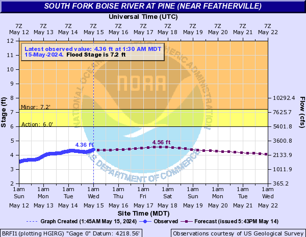
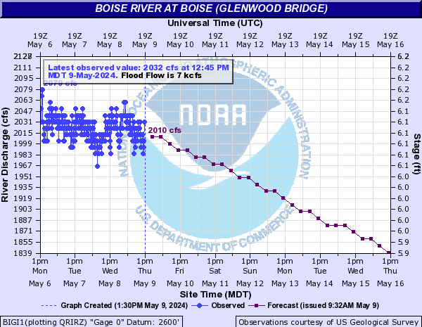
| Boise River | 7.2 | 4.19 ft | -0.2 | 4.26 | 4.16 | 4.14 | 4.02 | 4.24 | 4.09 | - | 1640.41 cfs | -24.73 | 1673.0 | 1673.0 | 1673.0 | 1673.0 | 1673.0 | 1673.0 | - | 8.95 ft | -0.31 | 9.49 | 8.9 | 8.74 | 8.64 | 9.4 | 9.27 | - | 7914.76 cfs | -545.28 | 7914 | 6296.5 | 5568.0 | 5056.3 | 5557.9 | 5064.2 | 7000.00 | 1902.0 cfs | -28.0 | 1902 | 1900.0 | 1900.0 | 1900.0 | 1900.0 | 1900.0 | - | 8.39 ft | -0.01 | - | - | - | - | - | - | - | 4.54 ft | -0.07 | - | - | - | - | - | - | - | 9.7 ft | +0.03 | 9.84 | 9.77 | 9.76 | 9.68 | 9.82 | 9.84 |
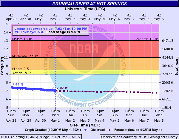
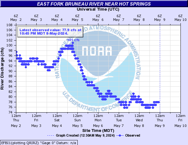
| Bruneau River | 9.5 | 7.71 ft | -0.1 | 7.71 | 7.65 | 7.53 | 7.39 | 7.28 | 7.17 | - | 120.0 cfs | +5.0 | - | - | - | - | - | - |
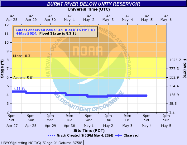
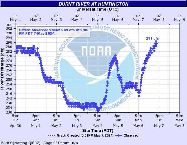
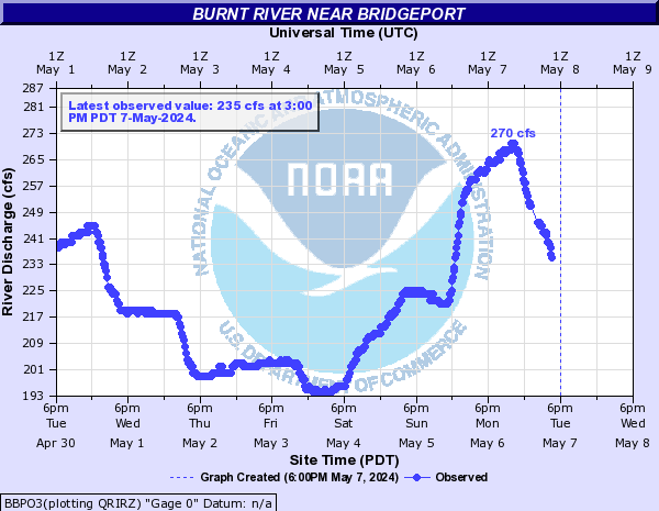
| Burnt River | 8.3 | 3.6 ft | 0.0 | - | - | - | - | - | - | - | 138.0 cfs | -1.0 | - | - | - | - | - | - | - | 98.0 cfs | -1.0 | - | - | - | - | - | - | - | 3.77 ft | -0.05 | - | - | - | - | - | - |
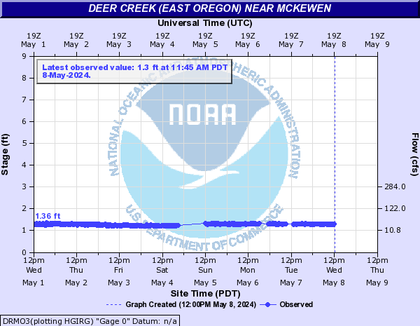
| Deer Creek (East Oregon) | - | 1.54 ft | -0.1 | - | - | - | - | - | - |
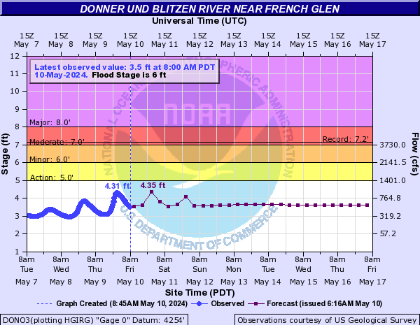
| Donner und Blitzen River | 6 | 3.45 ft | -0.07 | 3.69 | 3.57 | 3.29 | 3.19 | 3.17 | 3.07 |
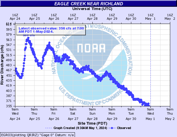
| Eagle Creek | - | 786.0 cfs | -117.0 | 1063.2 | 786.4 | 808.6 | 815.2 | 1006.1 | 1055.5 | - | 583.0 cfs | -97.0 | - | - | - | - | - | - |
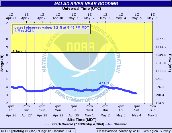
| Malad River | - | 177.0 cfs | -9.0 | - | - | - | - | - | - | - | 3.69 ft | -0.11 | - | - | - | - | - | - |
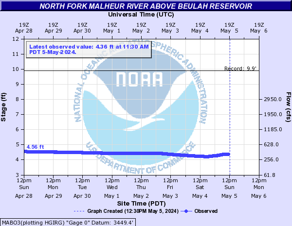
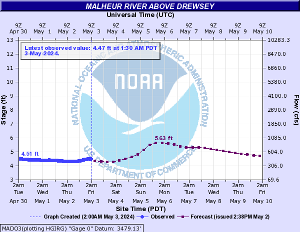
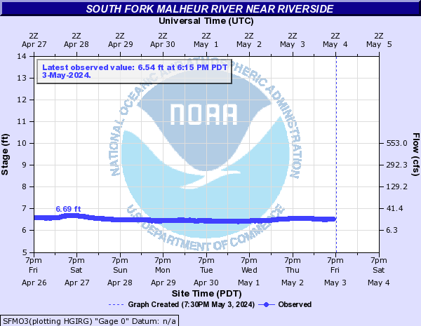
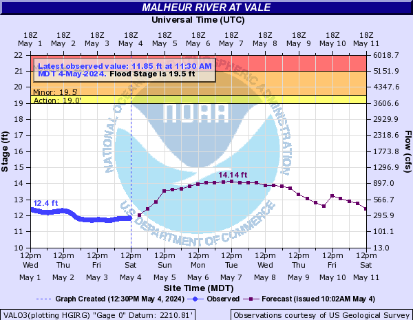
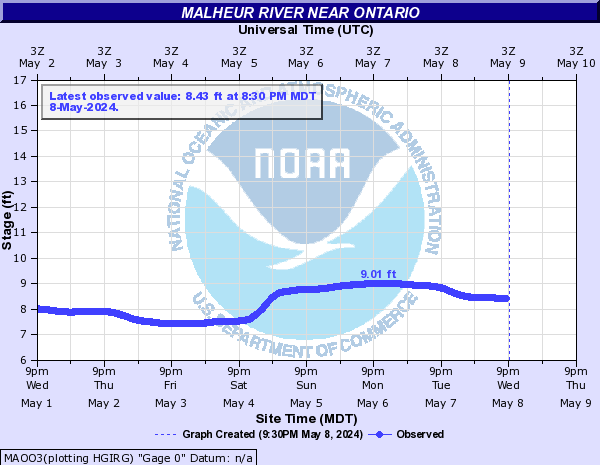
| Malheur River | - | 4.49 ft | -0.05 | - | - | - | - | - | - | - | 3.29 ft | 0.0 | - | - | - | - | - | - | - | 4.05 ft | -0.11 | 4.05 | 4.0 | 3.94 | 3.89 | 3.85 | 3.79 | - | 6.26 ft | -0.11 | - | - | - | - | - | - | 19.5 | 11.3 ft | +0.16 | 11.68 | 11.26 | 11.25 | 11.02 | 11.68 | 11.57 | - | 4.44 ft | +0.02 | - | - | - | - | - | - | - | 7.06 ft | +0.22 | - | - | - | - | - | - |
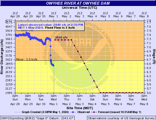
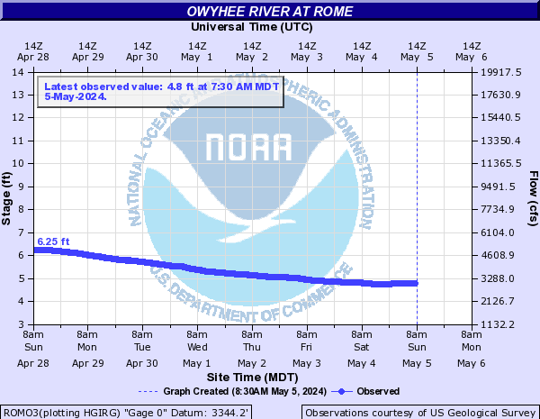
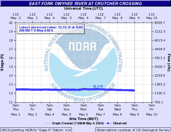
| Owyhee River | 3000.00 | 1246.0 cfs | -6.0 | 1250.0 | 1250.0 | 1250.0 | 1250.0 | 1250.0 | 1250.0 | - | 4.28 ft | -0.13 | - | - | - | - | - | - | - | 11.92 ft | -0.03 | - | - | - | - | - | - |
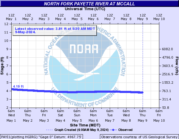
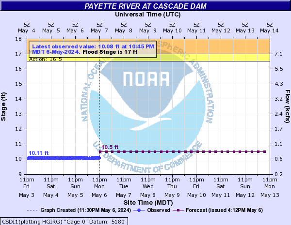
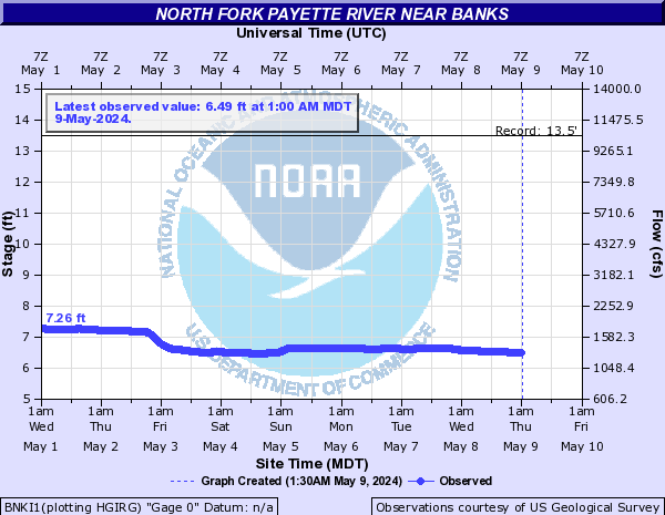
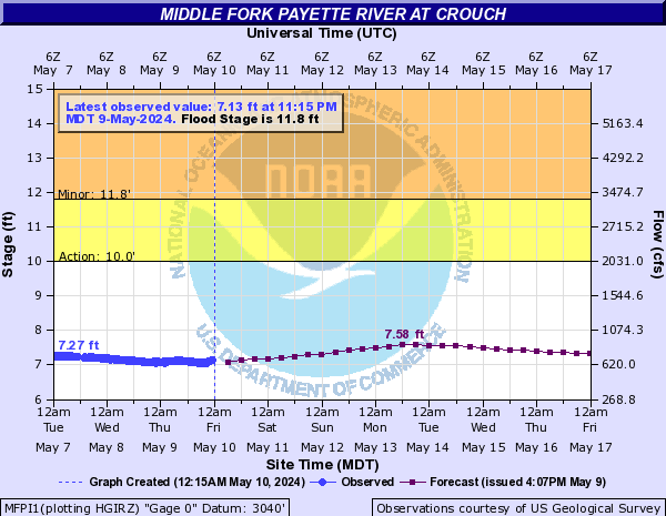
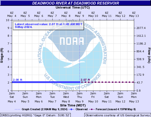
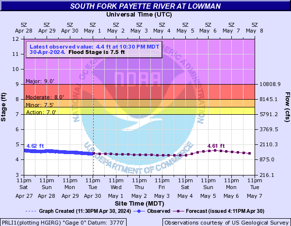
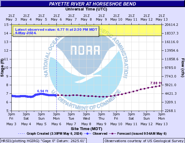
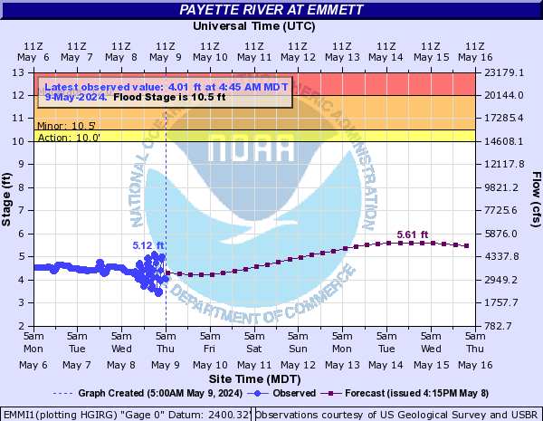
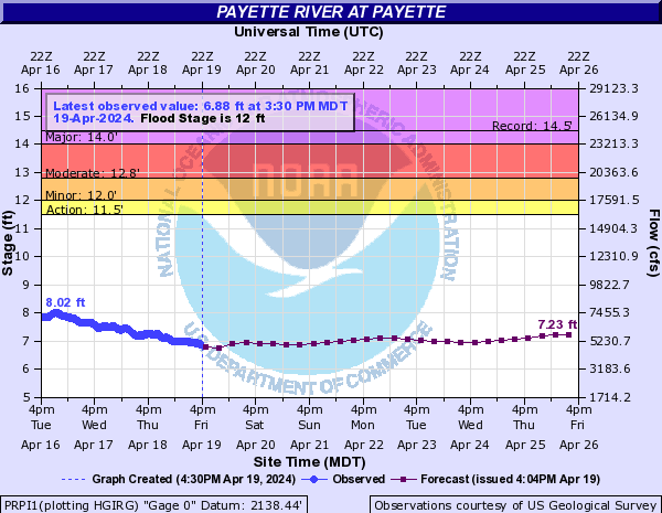
| Payette River | - | 4.74 ft | -0.57 | - | - | - | - | - | - | 17 | 10.99 ft | +0.02 | 11.2 | 11.2 | 11.2 | 11.2 | 11.2 | 11.2 | - | 7.34 ft | -0.07 | - | - | - | - | - | - | 11.8 | 8.09 ft | -0.24 | 8.71 | 8.07 | 7.93 | 7.83 | 8.61 | 8.42 | - | 3.73 ft | 0.0 | 3.74 | 3.74 | 3.74 | 3.74 | 3.74 | 3.74 | 7.5 | 5.1 ft | -0.18 | 5.1 | 5.0 | 4.86 | 4.76 | 4.88 | 4.89 | - | 8.4 ft | -0.27 | 8.4 | 8.27 | 7.99 | 7.8 | 8.12 | 8.18 | 10.5 | 6.16 ft | -0.15 | 6.16 | 5.87 | 5.49 | 5.25 | 5.53 | 5.76 | - | 11.91 ft | -0.18 | - | - | - | - | - | - | 12 | 7.34 ft | -0.16 | 7.34 | 7.11 | 6.78 | 6.58 | 6.63 | 7.01 |
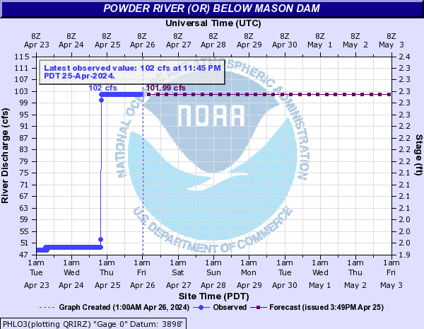
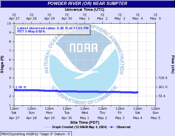
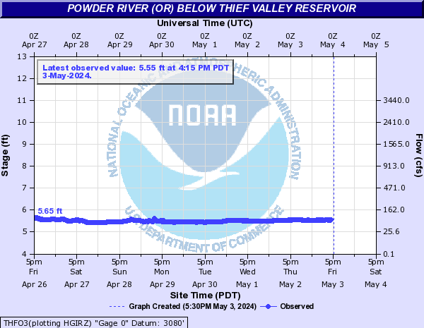
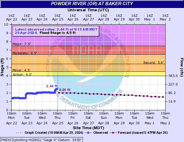
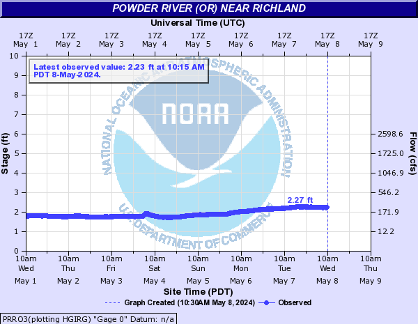
| Powder River | - | 311.0 cfs | 0.0 | 311 | 310.0 | 310.0 | 310.0 | 310.0 | 310.0 | - | 2.8 ft | -0.06 | - | - | - | - | - | - | - | 6.02 ft | -0.29 | - | - | - | - | - | - | 4.5 | 3.32 ft | +0.02 | 3.32 | 3.3 | 3.29 | 3.29 | 3.31 | 3.29 | - | 2.06 ft | -0.04 | - | - | - | - | - | - |
| Salmon River | - | 5.19 ft | -0.31 | - | - | - | - | - | - | - | 5.8 ft | -0.1 | - | - | - | - | - | - | - | 4.79 ft | -0.33 | 4.79 | 4.62 | 4.27 | 4.01 | 4.15 | 4.16 |
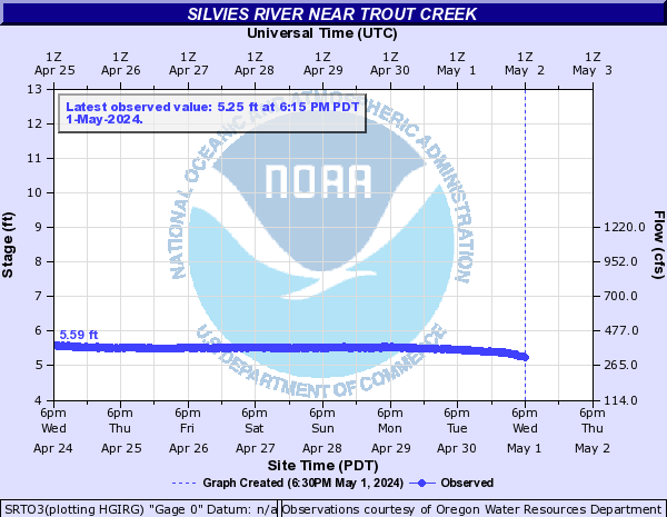
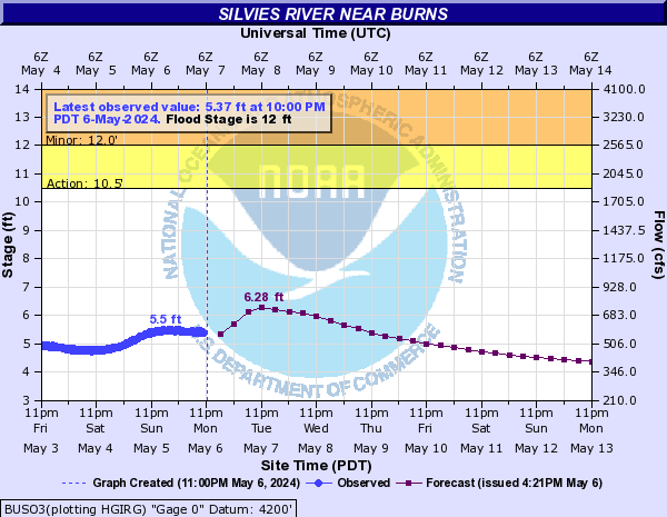
| Silvies River | - | 4.09 ft | -0.08 | - | - | - | - | - | - | 12 | 3.0 ft | -0.13 | 3.01 | 2.99 | 2.89 | 2.82 | 2.77 | 2.69 |
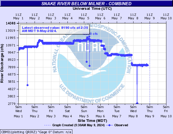
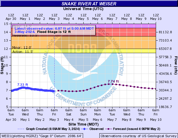
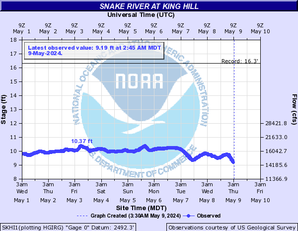
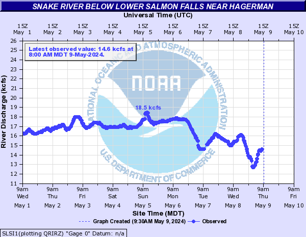
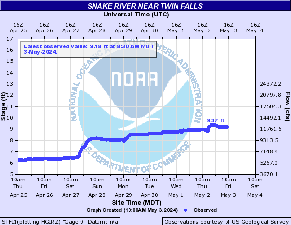
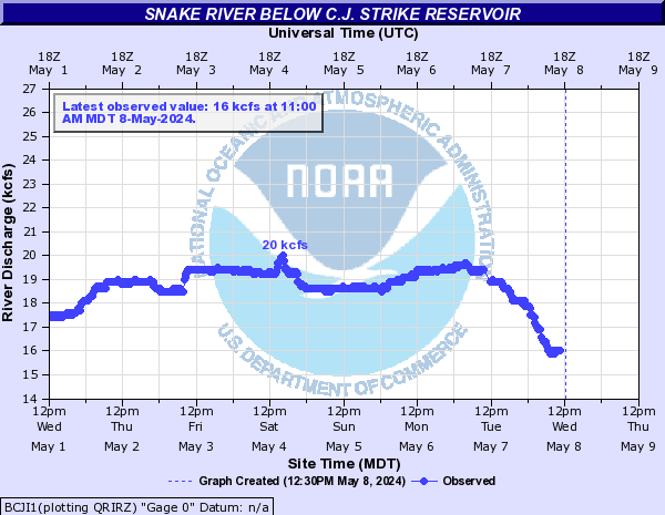
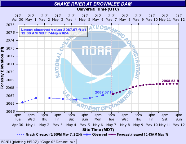
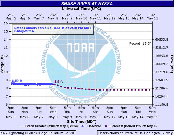
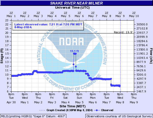
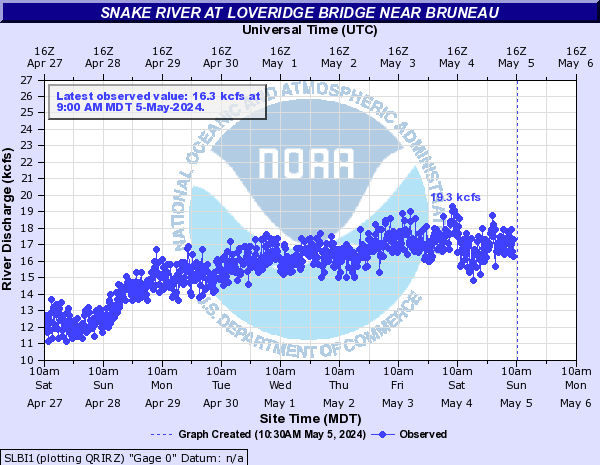
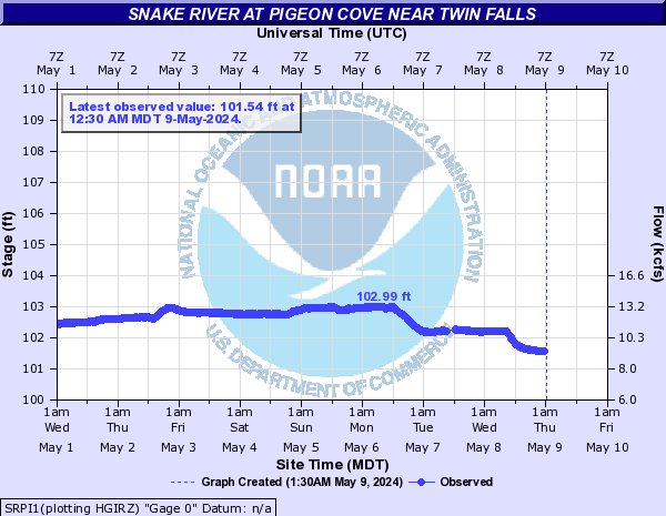
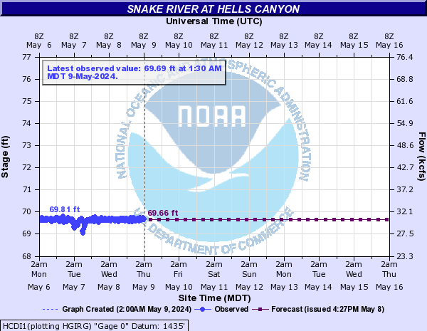
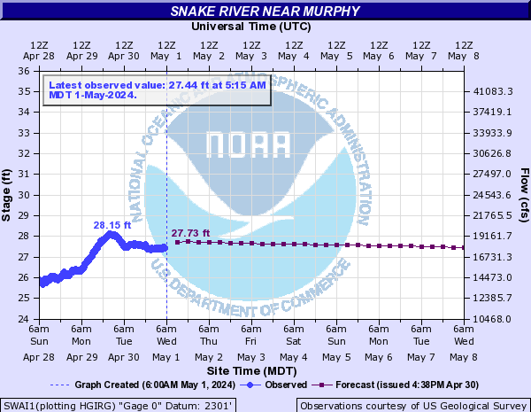
| Snake River | - | 559.0 cfs | -102.0 | - | - | - | - | - | - | 12 | 5.35 ft | 0.0 | 5.39 | 5.35 | 5.04 | 4.88 | 4.94 | 5.12 | - | 6.06 ft | -0.24 | - | - | - | - | - | - | - | 5810.0 cfs | -200.0 | - | - | - | - | - | - | - | 2.67 ft | +0.23 | - | - | - | - | - | - | - | 7230.0 cfs | -300.0 | - | - | - | - | - | - | - | 8930.0 cfs | +400.0 | - | - | - | - | - | - | - | 2069.71 ft | +0.02 | 2072.25 | 2070.04 | 2070.46 | 2070.88 | 2071.3 | 2071.73 | - | 6.25 ft | +0.15 | 6.25 | 6.21 | 6.14 | 6.08 | 6.07 | 6.06 | - | 1.12 ft | -0.07 | - | - | - | - | - | - | - | 2.1 ft | +0.03 | - | - | - | - | - | - | - | 556.0 cfs | -97.0 | - | - | - | - | - | - | - | 7060.0 cfs | -250.0 | - | - | - | - | - | - | - | 96.38 ft | +0.01 | - | - | - | - | - | - | - | 68.55 ft | -0.06 | 68.55 | 67.12 | 66.58 | 66.29 | 66.24 | 66.57 | - | 22.26 ft | -0.59 | - | - | - | - | - | - |
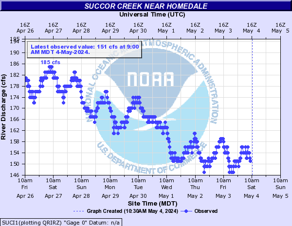
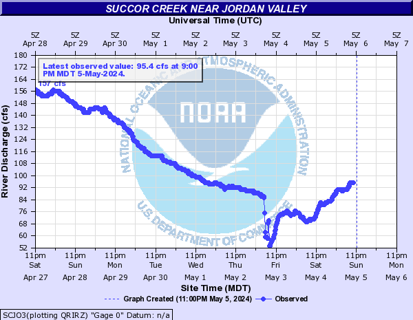
| Succor Creek | - | 117.0 cfs | +5.0 | - | - | - | - | - | - | - | 65.9 cfs | -5.6 | - | - | - | - | - | - |
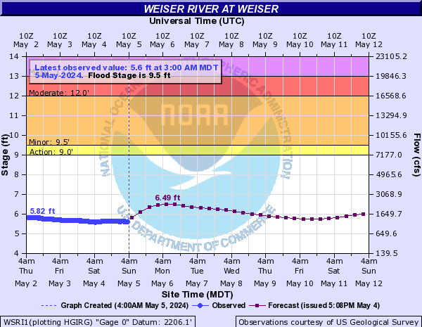
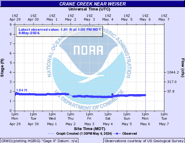
| Weiser River | 9.5 | 6.06 ft | -0.14 | 6.51 | 6.0 | 5.84 | 5.76 | 6.42 | 6.35 | 12 | 5.08 ft | -0.15 | 6.0 | 5.03 | 4.91 | 5.0 | 6.0 | 5.67 |
| Other Rivers and Creeks | - | 8.2 ft | -0.01 | - | - | - | - | - | - | - | 3.77 ft | +0.01 | - | - | - | - | - | - | - | 1.14 ft | -0.01 | - | - | - | - | - | - | - | 4.79 ft | 0.0 | - | - | - | - | - | - | - | 11.2 cfs | +1.37 | - | - | - | - | - | - | - | 3.73 ft | -0.05 | - | - | - | - | - | - | - | 3.1 ft | +0.09 | - | - | - | - | - | - | - | 1.23 ft | -0.01 | - | - | - | - | - | - | - | 1.37 ft | 0.0 | - | - | - | - | - | - | - | 470.0 cfs | -22.0 | - | - | - | - | - | - | - | 4.44 ft | -0.26 | - | - | - | - | - | - | - | 464.0 cfs | -55.0 | - | - | - | - | - | - | 8.8 | 3.89 ft | -0.1 | 4.39 | 3.88 | 3.75 | 3.65 | 4.39 | 4.02 | - | 154.0 cfs | -29.0 | - | - | - | - | - | - | - | 736.0 cfs | -142.0 | - | - | - | - | - | - | - | 198.0 cfs | -45.0 | - | - | - | - | - | - | - | 4.54 ft | +0.04 | - | - | - | - | - | - | - | 2.69 ft | -0.08 | - | - | - | - | - | - | - | 2.69 ft | -0.08 | - | - | - | - | - | - | - | 7.38 ft | -0.03 | - | - | - | - | - | - | - | 6.99 ft | -0.37 | - | - | - | - | - | - | - | 3.11 ft | -0.02 | - | - | - | - | - | - | - | 342.0 cfs | -23.0 | - | - | - | - | - | - |
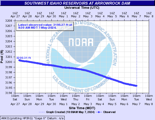
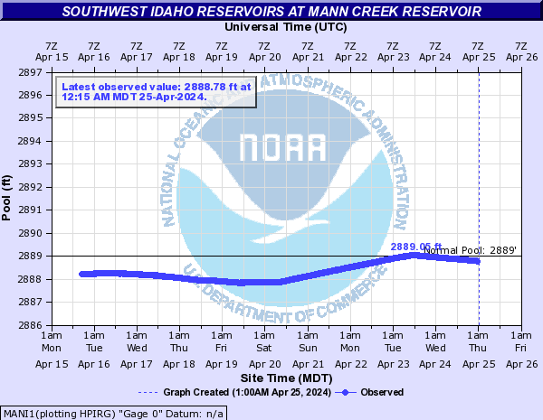
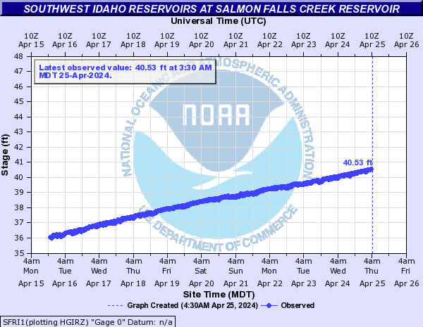
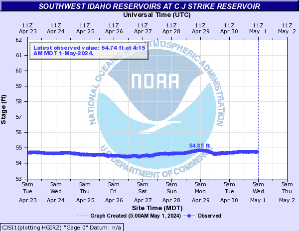
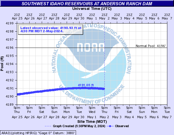
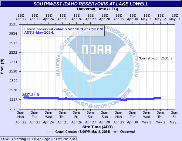
| Southwest Idaho Reservoir Trends | - | 3197.25 ft | +0.19 | - | - | - | - | - | - | - | 2888.45 ft | -0.1 | - | - | - | - | - | - | - | 44.71 ft | -0.01 | - | - | - | - | - | - | - | 54.82 ft | +0.09 | - | - | - | - | - | - | - | 4193.94 ft | +0.43 | - | - | - | - | - | - | - | 2529.02 ft | -0.06 | - | - | - | - | - | - | - | 5331.17 ft | +0.39 | 5333.66 | 5331.3 | 5331.59 | 5331.83 | 5332.13 | 5332.47 |
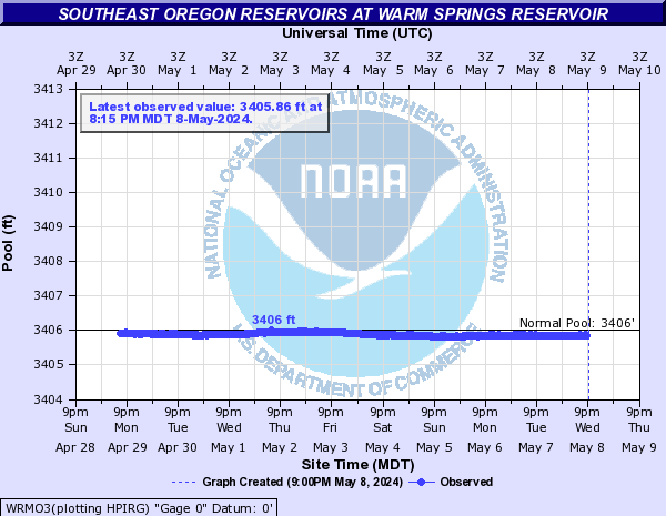
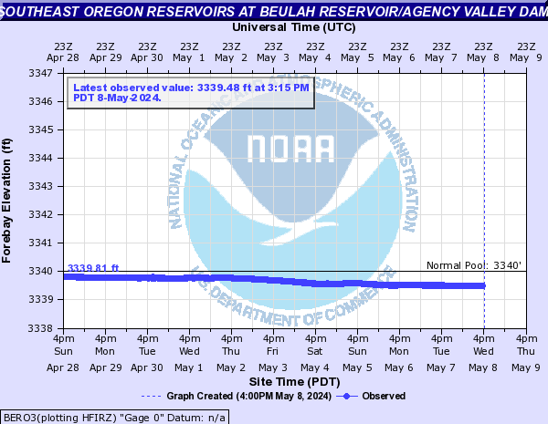
| Southeast Oregon Reservoir Trends | - | 2514.5 ft | -0.1 | - | - | - | - | - | - | - | 3405.88 ft | -0.01 | - | - | - | - | - | - | - | 3339.85 ft | -0.03 | - | - | - | - | - | - |
| Southwest Idaho Reservoirs | |||||||||
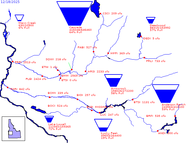 | |||||||||
| Southeast Oregon Reservoirs | |||||||||
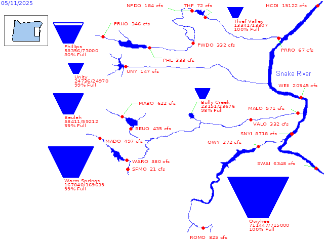 | |||||||||