
Photo Courtesy of Bob Perkins; Sheep Herder Hill Fire, Casper - September, 2012.
While the state of Wyoming certainly receives its fair share of Tornadoes, Severe Thunderstorms, and Wind Damage, wildfires are also a concern across the state, especially in Wyoming's forests and grasslands.
What is "Fire Weather?"
|
Fire Weather: A broad term used to describe weather variables that influence fire potential, behavior, and suppression.
The primary weather variables that are important to the fire community are:
1. Wind - probably the most influential of all the variables; not only does the wind fan flames and increase the intensity of fires, it also has the largest influence on the speed and direction of fire spread.
2. Relative Humidity - a measure of how moist or dry the atmosphere is, expressed as a percentage. Extended periods of low humidity (less than 15% prompts extra care in the fire community) can dry out grasses, logs, trees, and everything else that burns so that a fire can consume these elements more readily.
3. Atmospheric Stability - the ease at which the atmosphere is able to move in the vertical. A "stable" atmosphere hinders fire growth, but leads to poor air quality around the fire as the smoke has difficulty dispersing. An "unstable" atmosphere can either lead to
a) Thunderstorms if there is enough moisture in the air or
b) an atmosphere that causes fires to become "plume dominated" and create their own little weather systems! Both situations are very dangerous for fire fighters.
|

 |
Fire Weather Products and Tools
The NWS issues Watches and Warnings for fire weather issues, just as we do for any other weather related hazard. Warnings for critical fire weather conditions that may lead to extreme fire behavior are called "Red Flag Warnings." A Red Flag Warning can be issued for the following reasons (usually a combination of the following reasons):
1. Strong Wind and Low Humidity - This is the most common combination that leads to a Red Flag Warning in Wyoming. If the Relative Humidity is expected to be at 15% or below for 3 or more hours, while, at the same time winds are expected to be sustained or frequently gust over 25 mph, then a Warning is needed.
2. Scattered Dry Thunderstorms - This is potentially of the highest impact since dry thunderstorms can bring many new fire starts in addition to very strong and erratic winds with little or no precipitation around the put out any fires that may start. If we are expecting 15% or more of a zone to be covered by dry thunderstorms, then a Warning will be issued.
3. Dry Cold Frontal Passage - a dry cold front is often associated with strong winds, a sudden wind shift, and low humidity (especially ahead of the frontal passage). This can be dangerous, especially if there are already widlfires burning with crews on the fires as the sudden shift in winds and strong winds can cause unpredictable fire behavior.
4. Haines Index of 6 - as discussed above, a very dry and unstable atmosphere will lead to plume-dominated fire behavior, something that is very dangerous for those working on or near a wildfire.
Collaborative Effort
Q: Does the NWS issue a Red Flag Warning every time the Relative Humidity drops below 15% and the winds gust over 25
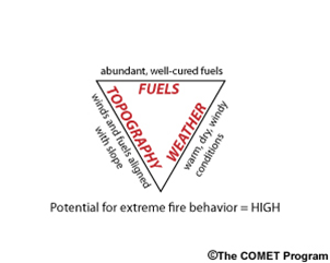 |
| The "Fire Triangle" shows the three major variables involved in fire behavior. |
mph?
A: No. In order for a Red Flag warning to be issued, we
must first consider whether or not the "fuels" are critical.
In other words, if the grass and sage is too wet to carry
a fire, then the weather will have little effect on any fire
that starts.
Fuels science is its own field of expertise. We here at the
National Weather Service rely on our partners at the BLM,
the Forest Service, State Forestry, among others to supply
us with information on how dry the fuels are. Once the
grasses and timber are "cured" we will then be on the
lookout for weather conditions that may encourage extreme
fire behavior.
Examples of different "fuels"
 |
 |
 |
Click Image To Enlarge
Photo courtesy of Lona Patton
Grasses are considered "fine" fuels. They carry fire much quicker than large trees. |
Click Image To Enlarge
This picture is from the Alpine Lake fire in 2012. Flame lengths are larger and fires often burn hotter in large trees when compared to grasses.
|
Click Image To Enlarge
Fuel types can vary greatly over short distances based on aspect, slope, exposure, and soil type.
|
How does Fire Weather affect you?
Perhaps the most direct effect that fire weather forecasts have on the public is if you are involved in agriculture. Every year, local fire departments are taxed during spring burning season because field burns escape their intended boundaries and cause property damage.
As mentioned previously, just because we have not issued a Red Flag Warning on they day that you plan to burn your field, that may be because our partners have not declared fuels for your area as "critical" but that certainly does not mean that a fire can not grow out of control if the wind gets a hold of it! The safest way to conduct a field or pile burn is to contact the National Weather Service first for a forecast!
However, fire weather forecasts can be used by anyone!
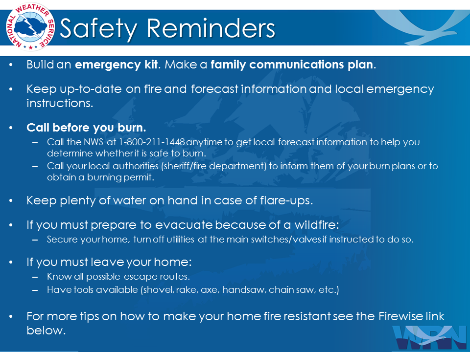
If a Red Flag Warning has been issued for your area, that means that you need to do everything within your power to prevent sparks from entering a grassy or wooded area.
Sparks are created in a number of unexpected ways including:
- From lawn mowers, chain saws, or any other mechanical aparatus used outside
- Sharpening axes and other blades can create sparks
- Welding torches
- Bar-b-q grills: you can still safely have a bbq on a day that has a Red Flag Warning in effect, just be sure that the coals are completely out before you leave the bbq unattended.
- Parking a car or truck with a hot muffler over dry grass can and will cause a wildfire if the conditions are right
- In some parks it is still okay to have a campfire in a designated area free of burnable material if the park has not already declared a burn ban; be sure to check with the local authorities before doing so.
Burn Scars and Flash Flooding
Wildfires and Flooding
The extraordinary wildfire season of 2012 has some lasting effects on the landscape, both in the immediate area and locations that may be several miles away. Locations downhill and downstream from burned areas are very susceptible to Flash Flooding and Debris Flows, especially near steep terrain. Rainfall that would normally be absorbed will run off extremely quickly after a wildfire, as burned soil can be as water repellant as pavement. As a result much less rainfall is required to produce a flash flood. A good rule of thumb is : "If you can look uphill from where you are and see a burnt-out area, you are at risk."
What is a debris flow?
As water runs downhill through burned areas it can create major erosion and pick up large amounts of ash, sand, silt, rocks and burned vegetation (Trees). The force of the rushing water and debris can damage or destroy culverts, bridges, roadways, and buildings even miles away from the burned area.
How Can I Be Prepared?
In the event of moderate to heavy rainfall, do not wait for a flash flood warning in order to take steps to protect life and property. Thunderstorms that develop over the burned area may begin to produce flash flooding and debris flows before a warning can be issued. If you are in an area vulnerable to flooding and debris flows, plan in advance and move away from the area. There may be very little time to react once the storms and rain start.
How much rainfall is required to produce a flash flood after a wildfire?
The time required for a flash flood to begin depends on how severe the fire was and how steep the terrain is, combined with the rate of precipitation. Steep terrain combined with a severe burn scar and light precipitation can result in flash flooding within minutes of precipitation beginning. Areas of less severe burn damage and flatter terrain will be able to absorb more water leading to more time before flooding develops even in heavier precipitation. A general rule of thumb is that half an inch of rainfall in less than an hour is sufficient to cause Flash Flooding in a burn area, but this can be more or less depending on the factors above. The susceptibility to flash flood within the burned area is greatest during the first two years following the fire. The important point is that for any burn area it will take much less rainfall to result in flash flooding than it would have before the wildfire occurred. In fact, Thunderstorms that develop over burn areas can produce Flash Flooding and Debris Flows nearly as fast as National Weather Service radar can detect the rainfall. If heavy rainfall is observed even for a very short time there is the potential for Flash Flooding and/or Debris Flows.
How long will there be an elevated risk of Flash Flooding and Debris Flows?
This depends on the severity of the wildfire that occurred as well as how much erosion occurs. It could take many years for vegetation to become reestablished and this is the main factor in slowing the precipitation run off that creates Flash Flooding and Debris Flows. Most burn areas will be prone to this activity for at least two years. Each wildfire burn area poses its own unique risk of Flash Flooding due to many factors including proximity to population centers, burn severity, steepness of terrain, and size of the burned area.
 |
 |
 |
|
Click Image To Enlarge
Pre-Fire Ground Conditions
|
Click Image To Enlarge
Post-Fire Ground Conditions
|
Click Image To Enlarge
What happens when
heavy rain falls on a
fire burn scar?
|
What should people who live near a burn scar do to protect themselves from potential flash flooding and debris flows?
- Have an evacuation/escape route planned that is least likely to be impacted by Flash Flooding or
Debris Flows
- Have an Emergency Supply Kit available
- Stay informed before and during any potential event; knowing where to obtain National Weather Service (NWS) Outlooks, Watches and Warnings via the NWS ,website, Facebook, Twitter or NOAA Weather Radio
- Be alert if any rain develops. Do not wait for a warning to evacuate should heavy rain develop.
- Call 911 if you are caught in a Flash Flood or Debris Flow
- Additional Flood Safety information is available on the web here
- Property Protection information from NRCS is available here
- Contact local officials for additional risk information and potential mitigation efforts
The National Weather Service office in Riverton will have additional information on the burn scars and their flash flood potential on the web soon. Flash flooding in burn areas will also be covered during Wyoming Flood Awareness Week.
Emergency Kit | Firewise
|


 Weather Story
 Weather Map
 Local Radar