HOME
FORECAST
Local
Graphical
Aviation
Marine
Rivers and Lakes
Hurricanes
Severe Weather
Fire Weather
Sunrise/Sunset
Long Range Forecasts
Climate Prediction
Space Weather
PAST WEATHER
Past Weather
Astronomical Data
Certified Weather Data
SAFETY
INFORMATION
Wireless Emergency Alerts
Weather-Ready Nation
Brochures
Cooperative Observers
Daily Briefing
Damage/Fatality/Injury Statistics
Forecast Models
GIS Data Portal
NOAA Weather Radio
Publications
SKYWARN Storm Spotters
StormReady
TsunamiReady
Service Change Notices
EDUCATION
NEWS
SEARCH
Search For
NWS
All NOAA
ABOUT
About NWS
Organization
For NWS Employees
National Centers
Careers
Contact Us
Glossary
Social Media
NWS Transformation
Local forecast by
"City, St" or ZIP code
Sorry, the location you searched for was not found. Please try another search.
Multiple locations were found. Please select one of the following:
Location Help
News Headlines
Showers & Thunderstorms Will Continue Thursday and Friday as Monsoon Moisture Lingers over the Plains. Drier Weather & Hot Temperatures Expected For the Weekend.
Customize Your
Weather.gov
Enter Your City, ST or ZIP Code
Remember Me
LOADING...
Cheyenne, WY
Weather Forecast Office
webcams
Weather.gov
>
Cheyenne, WY
> webcams
Current Hazards
Experimental Graphical Hazardous Weather Outlook
Storm and Precipitation Reports
Outlooks
Submit a Storm Report
Current Conditions
Satellite
Local Snowfall Reports
Local Ice Accumulation Reports
Observed Precipitation
Snowfall Analysis
Observations
Local Storm Reports
Road Conditions by State
CYS - 5 Min Obs
BFF - 5 Min Obs
Radar
Local Enhanced Radar
Local Standard Radar (low bandwidth)
Regional Standard Radar (low bandwidth)
Forecasts
Experimental Probabilistic Quantitative Precipitation Forecast
Fire Weather
Experimental Heat Risk
Winter Weather
Forecast Discussion
Hourly Forecasts
Recreation
High Wind
Snowfall Probabilities
Aviation
Rivers and Lakes
National Water Prediction Service (NWPS)
Area Hydrographs
Climate and Past Weather
Drought
Event Summaries
Local
NOAA Climate Service
Monthly/Annual/Water Year Climate Plots
Fall Freeze Stats
Spring Freeze Stats
Local Drought Dashboard
Local Programs
Publications
Blog
CoCoRaHS
Hail Climatology
SkyWarn & Spotter Classes
Weather Information for Decision Support
Web Cams by Highway
Cold Weather Advisory for Newborn Livestock
NWS Cheyenne Office Information
NWS Text Products
NOAA Weather Radio
Burn Scar Floods & Debris Flows
Wyoming Decision Support Page
Current Conditions
Forecast
Aviation
Severe Weather
Hydrology
Drought
Winter Weather
Road Webcams
Fire Weather
Contact
Web Cameras Across Southeast Wyoming and the Western Nebraska Panhandle
Continental Divide (WY)
to Lodgepole (NE)
MM 184(WY)-77(NE)
Wyo Hill
Casper
MM 3 to 187
All Southeast
Wyoming Webcams
All Western
Nebraska Webcams
Web Cams Across Southeast Wyoming By Route
Lusk
Red Bird
Natrona
Lusk
Duck Creek
Walcott Jct
Hanna Jct
Rock River
Gun Barrel
Rawhide Creek
Mule Creek Jct
Pumpkin Vine
Muddy Gap
Beaver Rim
Douglas
Belle Fourche
I-80 Summit
Hynds Lodge
Wildcat Trail
Skyline
CO/WY Border
Miscellaneous
Web Cams Across the Western Nebraska Panhandle By Route
Harrison
Hay Springs
Henry
Scottsbluff
Broadwater
Dalton
Hemingford
NE/SD Border
Mitchell
Kimball
Wildcat Hills
NE/SD Border
Miscellaneous
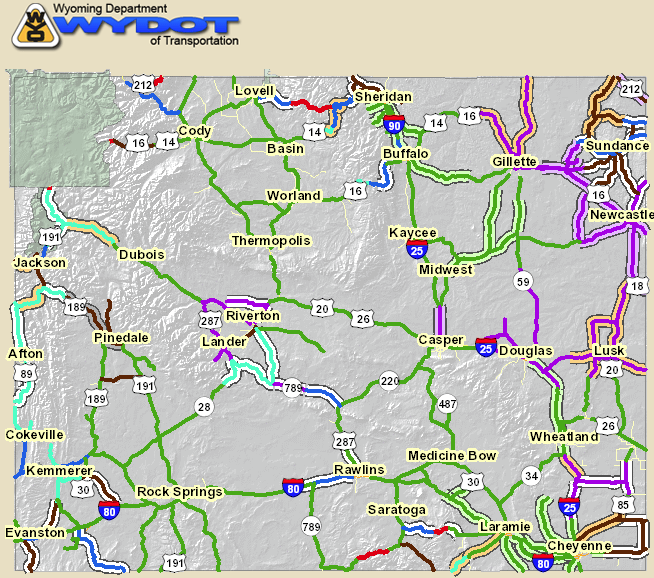
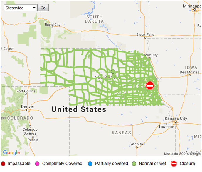
Click the Images Below for the Latest Road Conditions
Wyoming
Nebraska
NOAA/NWS Hover Webcam Map
Weather Story
Weather Map
Local Radar
Follow us on X
Follow us on Facebook
Follow us on YouTube
CYS RSS Feed


 Weather Story
 Weather Map
 Local Radar