Overview
|
A strong winter storm affected much of the Upper Midwest on December 11th and December 12th, 2010. A surface low moved east from northern Nebraska late in the day on December 10th, and tracked into Ohio by the morning of December 12th, intensifying as it moved east. Leading up to the storm, weather forecast models varied considerably in the track of the low. It turned out that the low wound up taking a more southerly track which placed the heaviest snow and blizzard conditions south of the NWS Duluth area of responsibility. However, there were still significant snowfall accumulations across parts of northwest Wisconsin. 6 inches or more of snow fell to the south of a line generally from Pine City, to Minong, to Drummond, to Washburn. Parts of the Gogebic Range in Ashland and Iron Counties received over a foot of snow due to a combination of system snow and lake effect snow. Gile reported 17.8 inches of snow. The highest snowfall total from purely system snow wound up being Sarona in far southern Washburn County (16.4 inches). A heavy band of lake effect snow, combined with wind gusts as high as 40 mph, lead to parts of Highway 2 west of the city of Ashland being shut down for a time as the road became impassible. The heavy snow and gusty winds closer to the lake caused similar problems on roads over much of northern Ashland and northern Iron counties. |
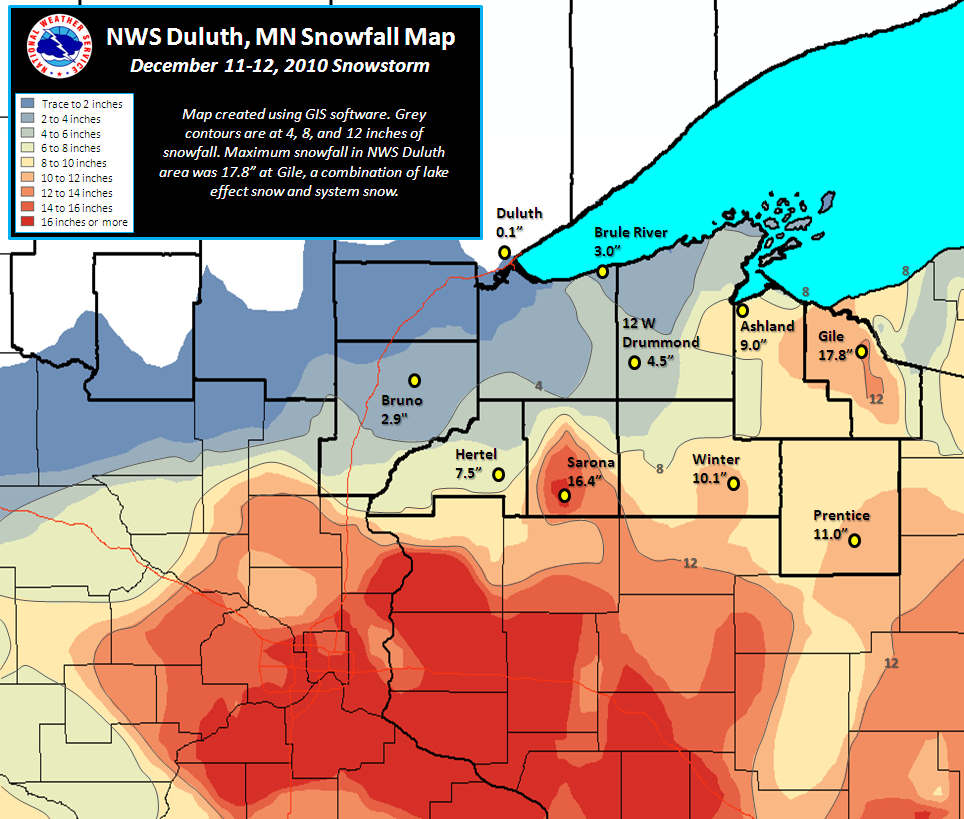 Snowfall accumulation map |
 |
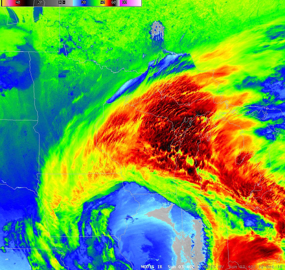 |
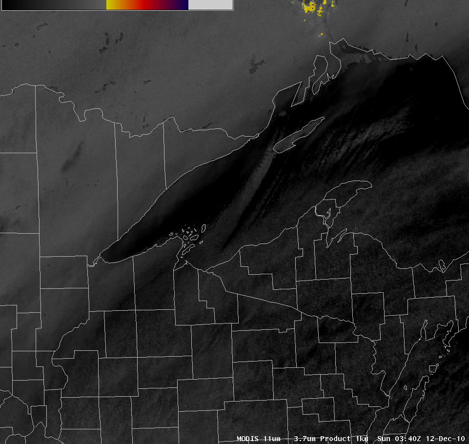
| POES 1km 11-3.9 micron satellite image at 9:40pm on December 11, 2010. Lake effect band of snow from Isle Royale to Ashland County becomes evident. | POES 1km IR satellite image at 9:40 pm on December 11, 2010. Convective elements near Green Bay had cloud tops as cold as -65C. |
Snowfall Reports
INCHES  LOCATION                 ST  COUNTY           TIME
 ------  -----------------------  --  --------------   -------
 17.80   GILE                     WI  IRON             0520 PM
 16.40   SARONA                   WI  WASHBURN         0430 AM
 12.00   HURLEY                   WI  IRON             0858 AM
 11.50   UPSON                    WI  IRON             0800 AM
 11.00   PRENTICE                 WI  PRICE            0813 PM
 10.10   2 SE WINTER              WI  SAWYER           0900 AM
 10.00   12 WSW SHELL LAKE        WI  BURNETT          1231 PM
 10.00   2 E GLIDDEN              WI  ASHLAND          0818 AM
  9.00   5 SW PHILLIPS            WI  PRICE            0807 PM
  9.00   PHILLIPS                 WI  PRICE            0715 PM
  9.00   ASHLAND                  WI  ASHLAND          0708 PM
  8.50   PARK FALLS               WI  PRICE            0620 AM
  8.30   8 S HAYWARD              WI  SAWYER           0925 PM
  8.00   TRADE LAKE               WI  BURNETT          0859 AM
  8.00   3 N BUTTERNUT            WI  ASHLAND          0600 AM
  7.50   HERTEL                   WI  BURNETT          0943 AM
  7.00   MONTREAL                 WI  IRON             0455 PM
  7.00   2 E ROCK CREEK           MN  PINE             0937 PM
  6.60   4 W CLAM LAKE            WI  BAYFIELD         0610 AM
  5.80   4 W WASHBURN             WI  BAYFIELD         1148 AM
  5.70   HAYWARD                  WI  SAWYER           0815 PM
  5.50   13 NE WEBSTER            WI  BURNETT          0943 AM


 INCHES  LOCATION                 ST  COUNTY           TIME
 ------  -----------------------  --  --------------   -------
  5.00   BAYFIELD                 WI  BAYFIELD         0815 AM
  5.00   MAPLE                    WI  DOUGLAS          0733 AM
  5.00   WASHBURN                 WI  BAYFIELD         1148 PM
  4.50   12 W DRUMMOND            WI  BAYFIELD         0500 PM
  4.10   3 WSW HINCKLEY           MN  PINE             0630 AM
  4.00   2 SW HINCKLEY            MN  PINE             0732 PM
  3.80   MADELINE ISLAND          WI  ASHLAND          0535 AM
  3.50   9 N BAYFIELD             WI  BAYFIELD         0700 AM
  3.00   13 N BRULE               WI  DOUGLAS          0700 AM
  2.90   BRUNO                    MN  PINE             0800 AM
  2.50   HAWTHORNE                WI  DOUGLAS          1122 AM
  2.50   5 SW BRUNO               MN  PINE             0814 AM
  2.50   4 S BRUNO                MN  PINE             0700 AM
  2.00   5 S HERBSTER             WI  BAYFIELD         0814 AM
  2.00   SOUTH RANGE              WI  DOUGLAS          0755 PM
  2.00   HOLYOKE                  MN  CARLTON          0328 PM
  1.30   12 N ISLE                MN  AITKIN           0800 AM
  1.00   MOOSE LAKE               MN  CARLTON          0600 PM
  0.80   FORT RIPLEY              MN  CROW WING        0400 PM
  0.50   3 E WRIGHT               MN  CARLTON          0600 AM
  0.10   5 NW DULUTH              MN  ST. LOUIS        1200 PM
Wind Chill Reports
After the low started to exit the area by the morning of December 12th, very cold air poured into the Northland. Combined with breezy winds on the backside of the low, this produced some very bitter wind chills across the area. Here is a list of those wind chills from the morning of December 12th. The Duluth and International Falls observations have been highlighted.
...LOWEST WIND CHILLS FROM SUNDAY MORNING DECEMBER 12 2010...

BELOW IS A LIST OF LOWEST WIND CHILLS AND MORNING LOWS ON SUNDAY
MORNING DECEMBER 12 2010. THE LIST IS SORTED BY WIND CHILL FROM
COLDEST TO WARMEST. THE LIST HAS BEEN BROKEN DOWN INTO SUB SECTIONS
TO MAKE IT EASIER TO READ...-25 TO -30...-30 TO -35...AND -35 AND
COLDER. THE COLDEST WIND CHILLS WERE IN INLAND PARTS OF NORTHERN ST.
LOUIS...COOK...AND LAKE COUNTIES IN MINNESOTA.

  WC     LOW    LOCATION             ST  COUNTY         TYPE
 ----    ---    ------------------   --  ------------   ------
  -38    -13    COOK CNTY AIRPORT    MN  COOK           AWOS
  -37    -27    INTERNATIONAL FALLS  MN  KOOCHICHING    ASOS
  -36    -15    TUCKER LAKE          MN  COOK           PRIVATE
  -35    -16    FERNBERG             MN  LAKE           RAWS
  -35    -13    HIBBING              MN  ST. LOUIS      RAWS

  WC     LOW    LOCATION             ST  COUNTY         TYPE
 ----    ---    ------------------   --  ------------   ------
  -34    -12    MCCOMBER             MN  ST. LOUIS      PRIVATE
  -34    -14    2 NE HIBBING HWY 169 MN  ST. LOUIS      MNDOT
  -34    -16    ISABELLA             MN  LAKE           RAWS
  -34    -18    ORR                  MN  ST. LOUIS      AWOS
  -34     -9    CLOQUET              MN  CARLTON        AWOS
  -33    -13    AURORA               MN  ST. LOUIS      PRIVATE
  -33    -19    LITTLEFORK           MN  KOOCHICHING    RAWS
  -33    -11    GRAND RAPIDS         MN  ITASCA         AWOS
  -33    -10    DULUTH AIRPORT       MN  ST. LOUIS      ASOS
  -32    -17    MARGIE HWY 71        MN  KOOCHICHING    MNDOT
  -32    -16    ORR                  MN  ST. LOUIS      RAWS
  -31    -18    7 NE BIGFORK         MN  ITASCA         MNDOT
  -31    -15    EFFIE                MN  ITASCA         RAWS
  -31     -4    GRAND MARAIS         MN  COOK           ASOS
  -31    -21    SEAGULL LAKE         MN  COOK           RAWS
  -30    -17    MEANDER              MN  ST. LOUIS      RAWS
  -30    -17    ELY                  MN  ST. LOUIS      AWOS
  -30    -15    BIGFORK              MN  ITASCA         AWOS
  -30    -12    HIBBING              MN  ST. LOUIS      ASOS

  WC     LOW    LOCATION             ST  COUNTY         TYPE
 ----    ---    ------------------   --  ------------   ------
  -28     -8    GRAND PORTAGE        MN  COOK           RAWS
  -28     -8    PINE RIVER           MN  CASS           AWOS
  -28     -8    MCGREGOR             MN  AITKIN         AWOS
  -28     -9    I-35 THOMPSON HILL   MN  ST. LOUIS      MNDOT
  -27     -5    DULUTH/LESTER PARK   MN  ST. LOUIS      PRIVATE
  -27     -8    DADS CORNER          MN  AITKIN         MNDOT
  -27    -15    KETFALLS             MN  ST. LOUIS      RAWS
  -26    -11    SAGINAW              MN  ST. LOUIS      RAWS
  -26    -10    BALL BLUFF           MN  AITKIN         MNDOT
  -26     -8    GRAND PORTAGE HWY 61 MN  COOK           MNDOT
  -26     -8    AITKIN               MN  AITKIN         AWOS
  -26     -6    TWO HARBORS          MN  LAKE           AWOS
  -26     -7    LEADER               MN  CASS           PRIVATE
  -26     -7    BRAINERD             MN  CROW WING      RAWS
  -26    -15    SQUAW LAKE           MN  ITASCA         MNDOT
  -26    -18    ASH RIVER            MN  ST. LOUIS      PRIVATE
  -25    -19    KABETOGAMA           MN  ST. LOUIS      RAWS
  -25     -4    DULUTH/35-GARFIELD   MN  ST. LOUIS      MNDOT
  -25     -8    MOOSE LAKE           MN  CARLTON        RAWS
  -25     -6    BRAINERD             MN  CROW WING      ASOS
  -25     -6    MOOSE LAKE           MN  CARLTON        AWOS
  -25     -7    EMILY                MN  CROW WING      MNDOT
  -25    -11    HILL CITY            MN  ITASCA         RAWS


 * THE LOW AT CRANE LAKE /KCDD/ WAS -26 BUT THE WIND WAS CALM
   DURING THE OVERNIGHT.

 * THE LOW AT MINNESOTA DOT SITE ON HIGHWAY 53 MILE POST 129
   NEAR RAY WAS -33 BUT THE WIND WAS CALM DURING THE NIGHT.
Additional Information
Summaries from other NWS Offices
 |
Media use of NWS Web News Stories is encouraged! Please acknowledge the NWS as the source of any news information accessed from this site. |
|

