Scattered thunderstorms with severe gusts, hail and a tornado risk are possible near a cold front from the Ohio Valley to the Mid-Atlantic tonight. Tropical Storm Bertha is expected to bring tropical storm conditions to portions of the Gulf Coast from the panhandle of Florida into Louisiana through Wednesday. Read More >
On the evening of the 10th a strong upper level disturbance and a powerful jet stream began diving out of the northern Rockies. This energy tracked right along a tight temperature gradient, caused by the transition from snow pack to no snow. As it did so, a surface low pressure began to develop over the northern Plains. The low pressure continued to gradually strengthen into the morning of the 11th, as it followed the line of snow cover east southeast into western Iowa.

The imagine above shows the powerful jet energy diving into the Plains, with the disturbance circled.
Temperatures ahead of the system soared into the 30s, 40s and even some lower 50s as precipitation overspread eastern Iowa, northwest Illinois and northeast Missouri. South of a line from Independence to the Quad Cities to Galesburg the precipitation began as all rain, to the north a wintry mix. However, continued warming of temperatures changed all precipitation over to rain on the morning of the 11th. Well to the north, along and north of the Iowa/Minnesota border, heavy snow had been falling since the previous night. As the low pressure continued to strengthen, it began to pull in colder air, and precipitation rapidly transitioned to snow across the Quad Cities forecast area. For most areas during the day on the 11th, the transition was quickly followed by the dry slot (an area with no, or relatively light precipitation). This limited most locations to a quick, slushy inch or so of snow. However, the dry slot was slow to reach the Highway 20 corridor, allowing snow to pile up much more quickly by evening.
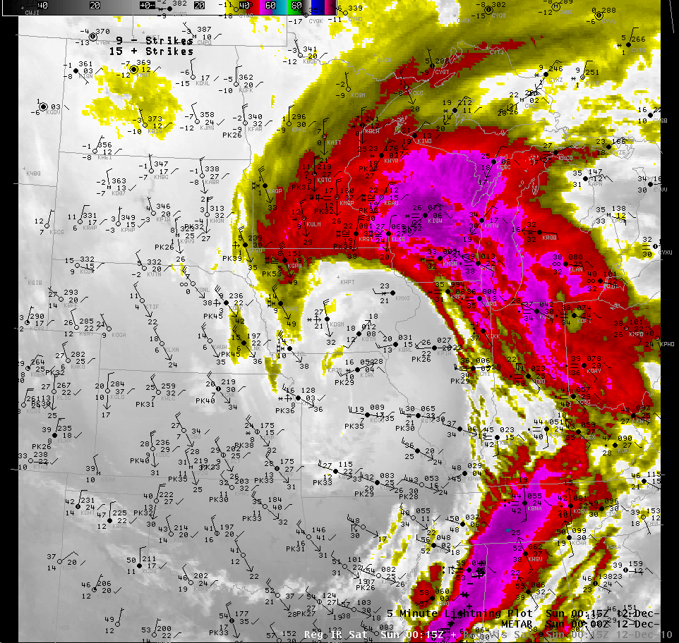
The above image shows the dry slot as the relatively darker area south of the bright colored cloud tops in this infrared satellite image.
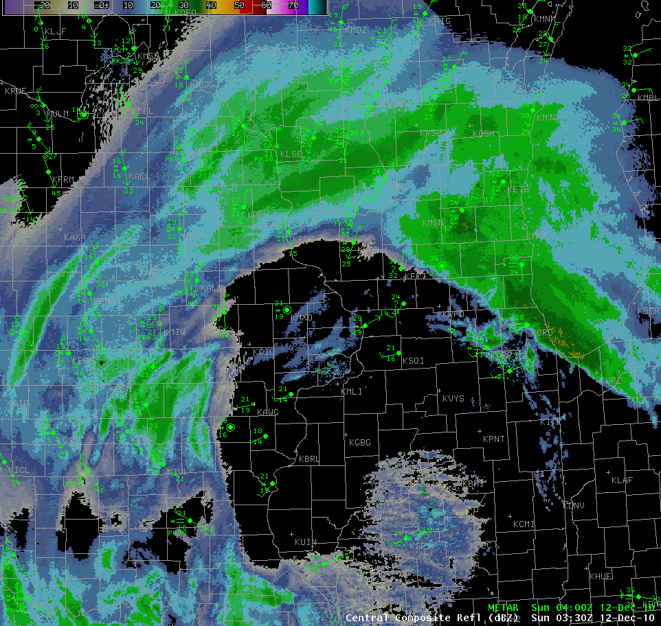
The above image is a radar mosaic showing the dry slot, with a lack of precipitation over eastern Iowa, northwest Illinois and extreme northeast Missouri
Late on the 11th and early on the 12th, the low continued to strengthen and slide east southeast towards northern Illinois. Precipitation wrapping around the system was finally able to work back into the area, as temperatures continued to tumble. As an Arctic high pressure system tried to slide in behind the storm winds began to pick up speed, as they tried to funnel between the systems. A light, fluffy snow coupled with sustained winds of 25-35 mph gusting to near 50 mph quickly enveloped east central Iowa in blizzard conditions. The wrap around snowfall weakened slightly as it crossed the Mississippi, sparing many along it the worst conditions.
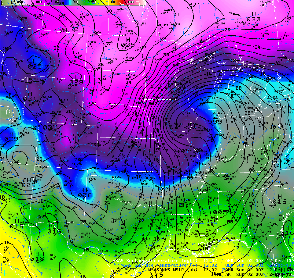
The above image shows sea level pressure (black lines) and temperature (color fill) shortly before blizzard conditions began in eastern Iowa
The following is a list of the strongest wind gusts reported late on the 11th and early on the 12th
ILLINOIS SITES
FREEPORT AWOS ....................... 37 MPH 1246 PM
MACOMB AWOS ............................ 43 MPH 824 AM
MOLINE ASOS ............................... 43 MPH 446 AM
SAVANNA AWOS ........................... 44 MPH 246 AM
STERLING ROCKFALLS AWOS . 44 MPH 925 AM
IOWA SITES
BURLINGTON ASOS .................... 48 MPH 456 AM
CEDAR RAPIDS ASOS ................. 51 MPH 214 AM
CLINTON AWOS ........................... 47 MPH 615 AM
DAVENPORT ASOS ...................... 47 MPH 329 AM
DUBUQUE ASOS .......................... 47 MPH 302 AM
FAIRFIELD AWOS ......................... 45 MPH 222 AM
INDEPENDENCE AWOS ............. 44 MPH 1208 AM
IOWA CITY ASOS .......................... 46 MPH 429 AM
KEOKUK AWOS ............................ 41 MPH 913 AM
MONTICELLO AWOS ................... 44 MPH 458 AM
MOUNT PLEASANT AWOS ......... 44 MPH 328 AM
MUSCATINE AWOS ...................... 44 MPH 348 AM
VINTON AWOS .............................. 46 MPH 1214 AM
WASHINGTON AWOS .................. 45 MPH 1023 AM
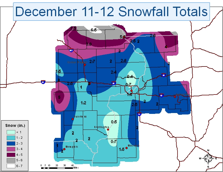
Early on the 12th the wrap around snow re-intensified producing an addition couple of inches accumulations across extreme western Illinois, with blizzard conditions once more. The snow finally pushed east of the forecast area by the afternoon of the 12th. When it was all said and done, 14-20 inches of snow had fallen across parts of Minnesota and Wisconsin, with widespread winds gusting above 50 mph causing blizzard conditions throughout those states extending into Iowa and Illinois. Below is a snowfall map for eastern Iowa, northwest Illinois and northeast Missouri for the 11th and 12th.