Duluth, MN
Weather Forecast Office
|
|
|
| Forecasts for Lake Superior |
| Western Lake Superior Forecasts and Information |
| Nearshore Marine Forecast - issued by the NWS in Duluth, MN |
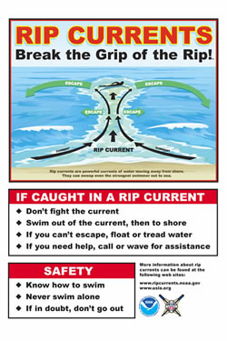
| Surf Zone Forecast - issued by the NWS in Duluth, MN Provides information on rip current threats on the beaches of Duluth and Superior. |
| Open Waters Forecast - issued by the NWS in Marquette, MI |
| GLERL - NOAA Coastal Forecasting System |
| Marine Observations for western Lake Superior |
| Duluth, MN (NOS Station) |
| Silver Bay, MN (NWS GLOS Station) |
| Grand Marais, MN (NOS Station) |
| Port Wing, WI (NWS GLOS Station) |
| Saxon Harbor, WI (NWS GLOS Station) |
| Devil's Island, WI (NDBC C-MAN Station) |
| Ontonagon, MI (NWS GLOS Station) |
| Rock of Ages, MI (NDBC C-MAN Station) |
| Passage Island, MI (NDBC C-MAN Station) |
| Western Lake Superior Buoy (48 NM N of Ironwood, MI - seasonal) |
| National Data Buoy Center Great Lakes Regional Map |
| Other Interest to Mariners |
|---|
| National Marine Homepage |
| Great Lakes Water Level Forecasts |
| Weather Observations |
Forecasts
Fire Weather
Great Lakes
Local Text Products
Winter Weather
Local Area Forecasts
Aviation
Marine
Rainy River Basin Page
Current Conditions
Current Observations
Public Information Statements
National Snowfall Map
NOHRSC Snow Analysis
Rain/Snow Reports
Winter Monitor
US Dept of Commerce
National Oceanic and Atmospheric Administration
National Weather Service
Duluth, MN
5027 Miller Trunk Highway
Duluth, MN 55811-1442
218-729-6697 - Duluth; 218-283-4615 - Intl Falls
Comments? Questions? Please Contact Us.