Overview
|
Widespread, destructive straight line winds blew across central Iowa during the day on August 10, 2020. The highest official wind gusts measured was 99 mph at the Marshalltown Airport with an unofficial wind gust of 106 mph at Le Grand (east of Marshalltown). The strongest winds were between the Highway 30 and Interstate 80 corridor (including, but not limited to the Des Moines metro, Ames, Newton, Marshalltown, Tama/Toledo, Carroll) from central Iowa eastward into east central Iowa and northern Illinois. Last update: March 30, 2022 4:46 a.m. CDT
StoryMap - August 10, 2020 Midwest Derecho
Other NWS Office Event Summaries: NWS Quad Cities | NWS Chicago | NWS Milwaukee NWS Central Illinois | NWS Northern Indiana | NWS Indianapolis
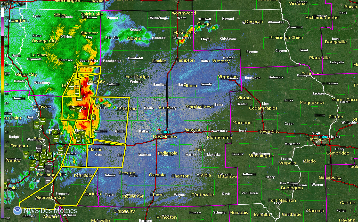
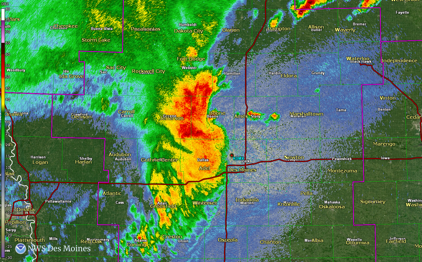
Wind Gusts Greater than 70 mph in NWS Des Moines' area of responsibility
|
|
 |
 |
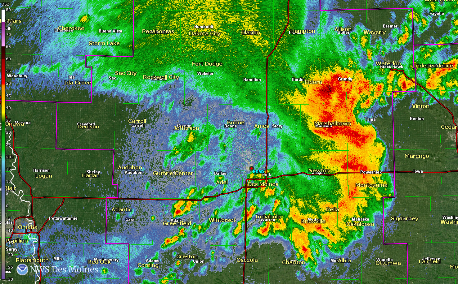 |
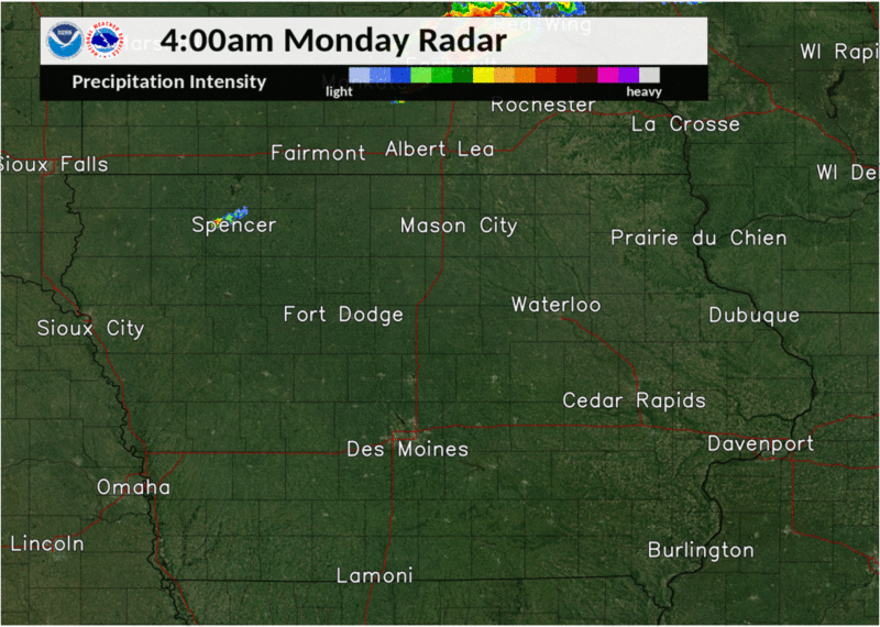
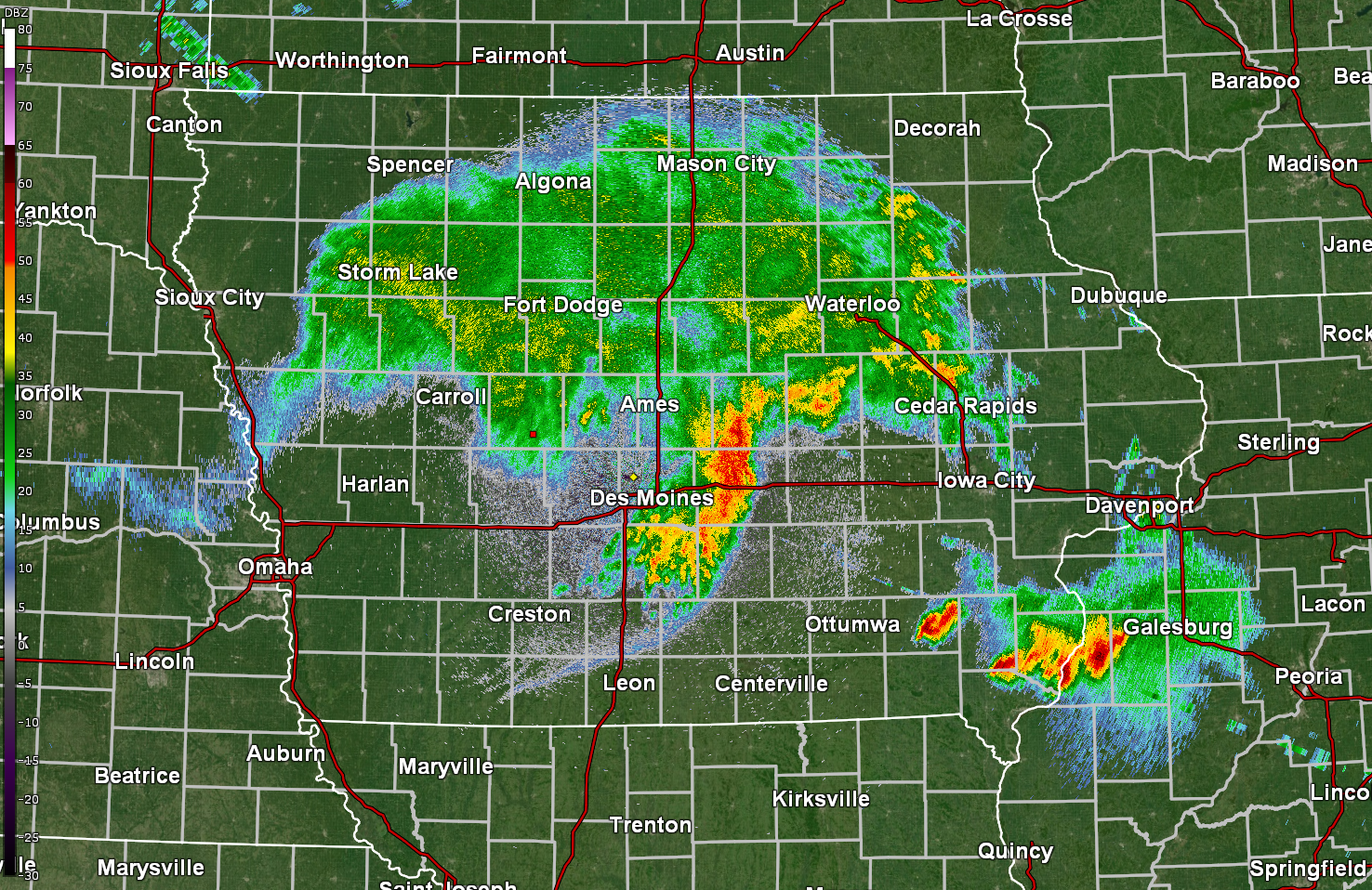
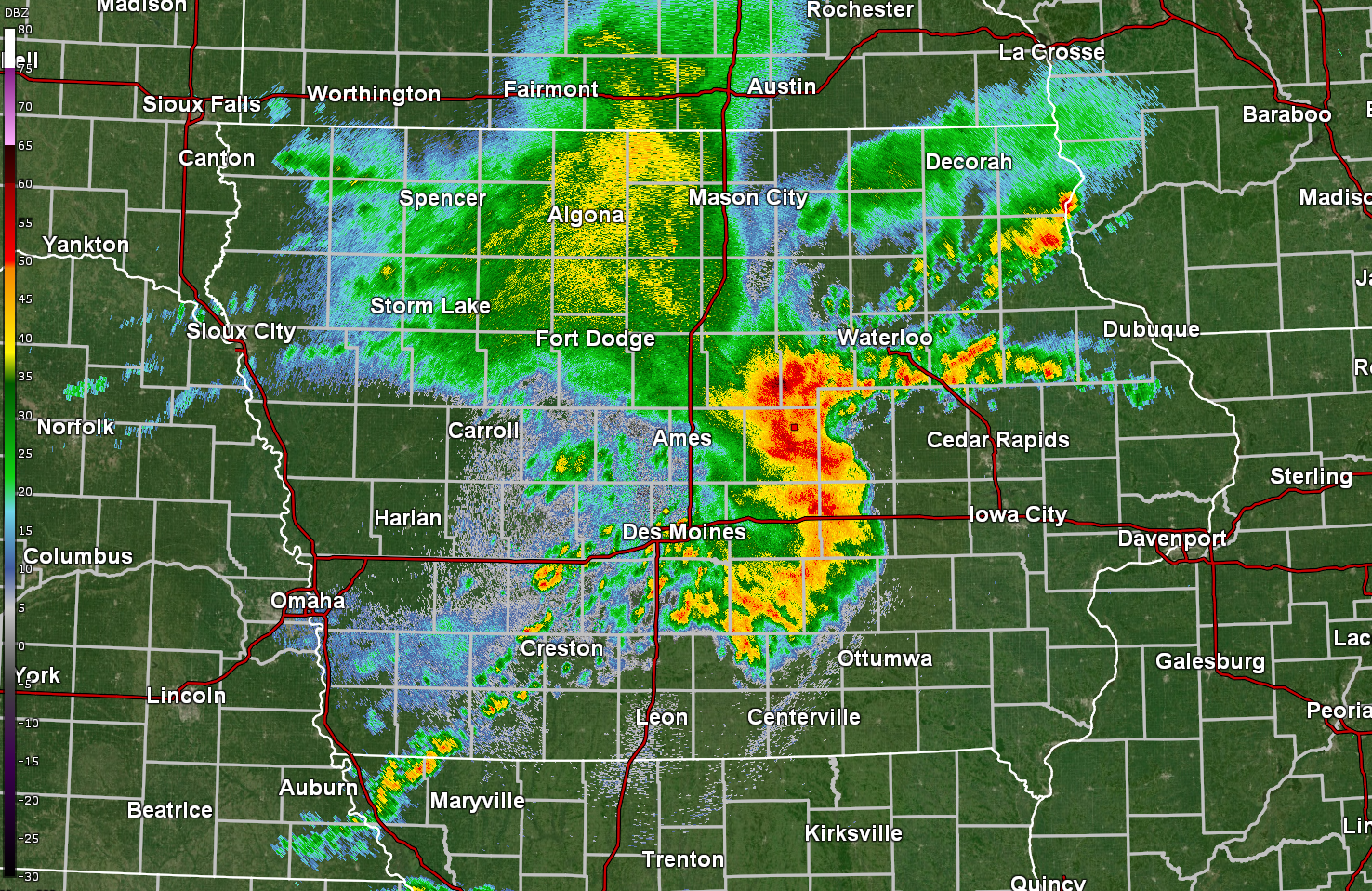
| 942am Des Moines Radar | 1046am Des Moines Radar | 1158am Des Moines Radar |
Derecho Overview
Overview images of the swath of damage and power outages from the derecho and the progression of the derecho on Monday, August 10, 2020.
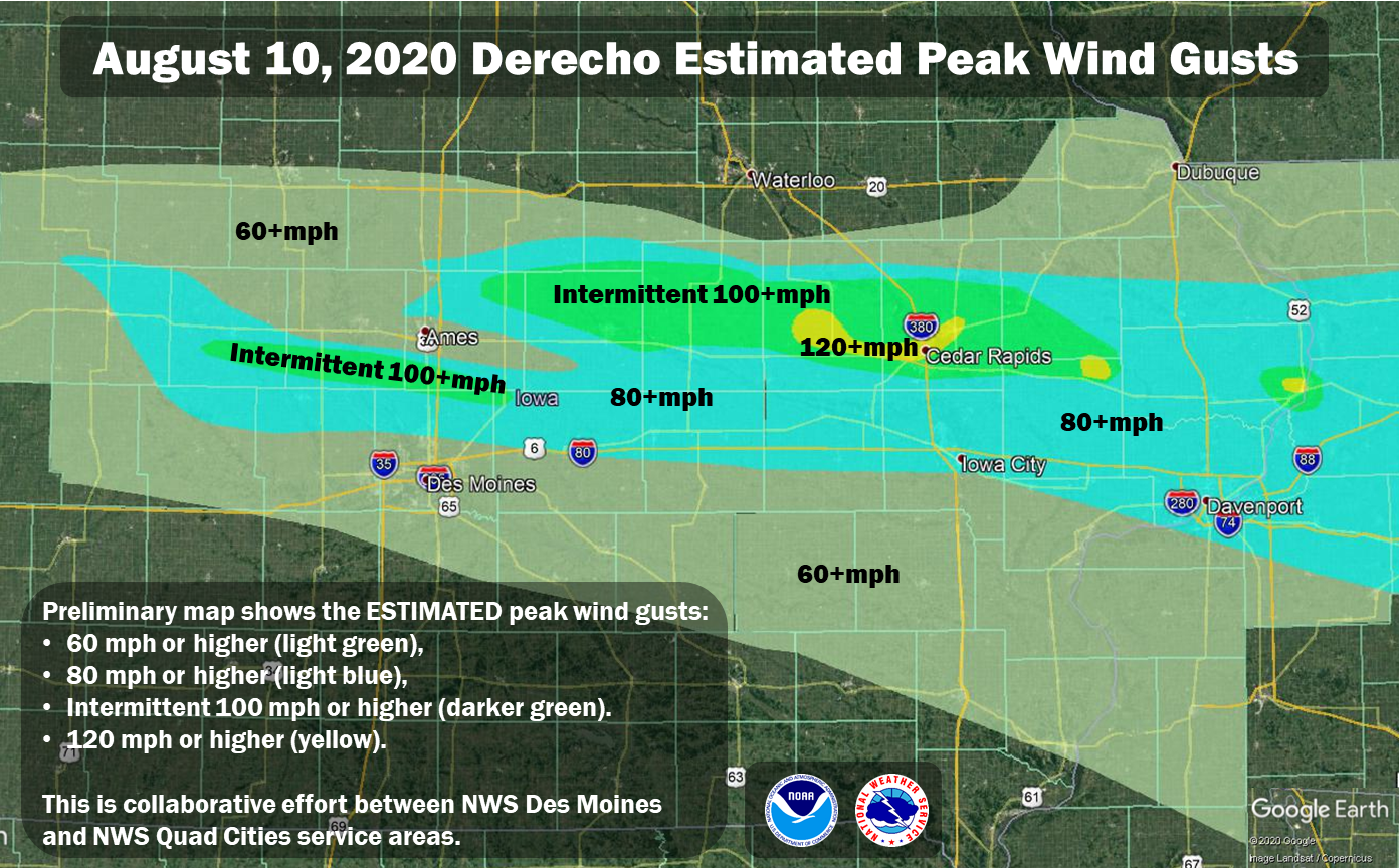 |
| Preliminary map of the estimated winds across central to eastern Iowa. There were to distinct locations of 100+mph winds with the area near Cedar Rapids estimating gusts of 120+mph! This map combines both NWS Des Moines and NWS Quad Cities service areas. Last updated 8/25/2020 4:15 a.m. CDT. KMZ available here - this is preliminary and subject to change. |
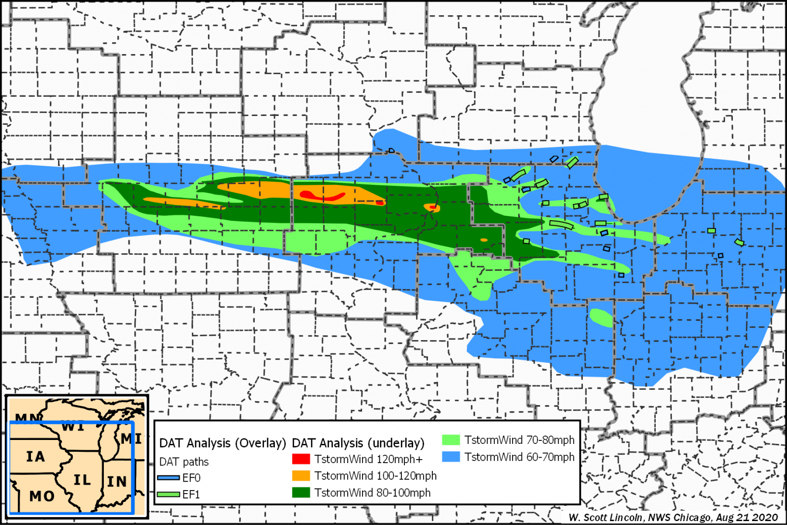 |
| Preliminary map above shows the estimated wind speeds of the August 10, 2020 derecho across the region as of August 21, 2020. This is a collaborative effort between weather forecast offices Des Moines, IA Sioux Falls, SD Omaha, NE, Quad Cities, IA/IL, La Crosse, WI, Milwaukee, WI, Chicago, IL, central Illinois, IL, northern Indiana, IN, Indianapolis, IN, northern Indiana, IN, and Grand Rapids, MI. Thanks to Scott Lincoln, WFO Chicago for working with numerous offices to gather and refine this regional map. |
 |
| Iowa Environmental Mesonet (IEM) feature showing August 11, 2020 Aqua MODIS satellite image showing crop damage (smiliar to above) with wind reports overlaid. Full feature can be viewed here. Image courtesy of the Iowa Environmental Mesonet. |
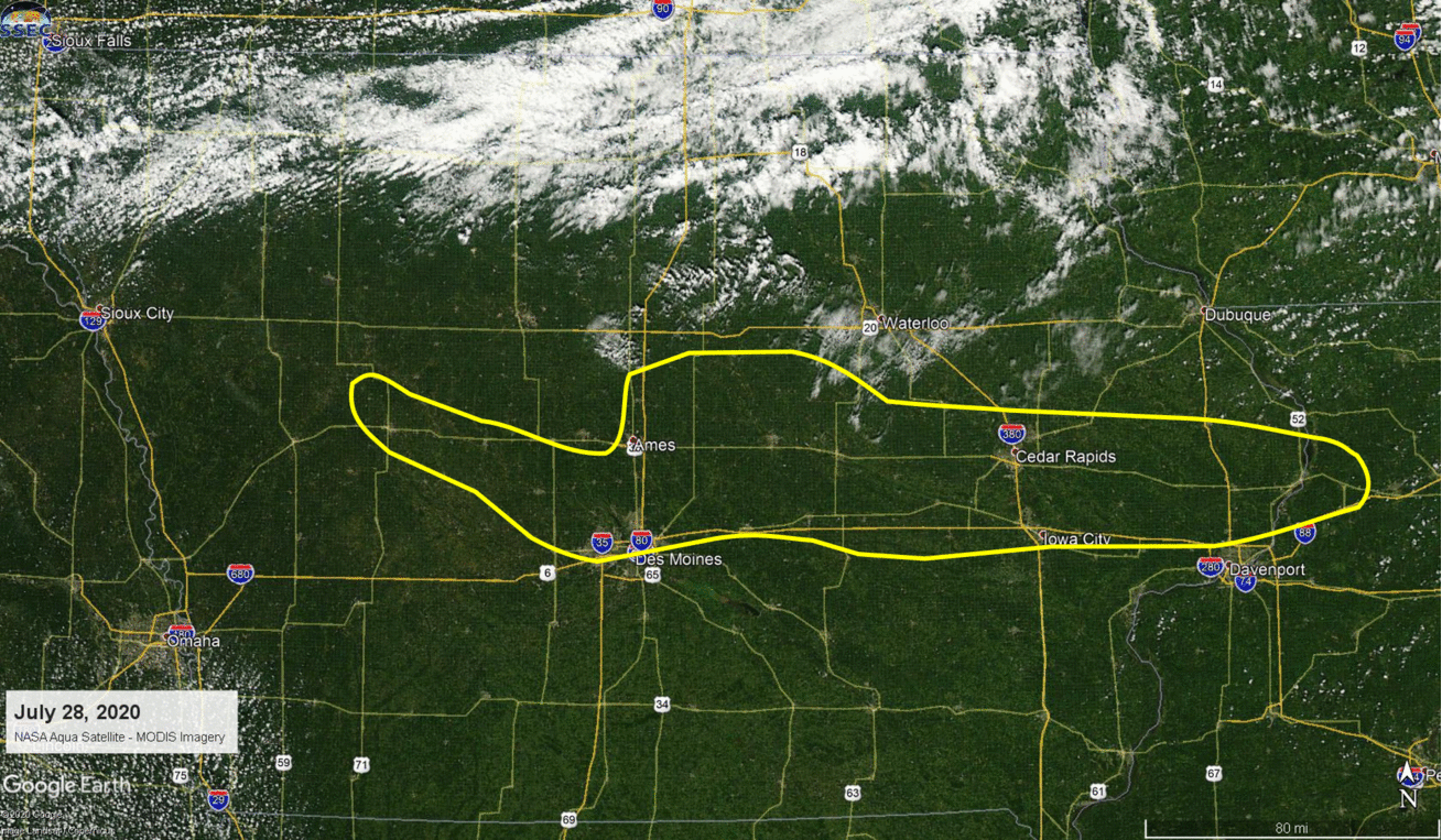 |
| NASA Aqua satellite MODIS imagery toggle between July 28, 2020 and August 15, 2020 showing the approximate damage area to cropland (outlined) from the derecho that moved across Iowa on August 10, 2020. Imagery courtesy MODIS Today at University of Wisconsin-Madison Space Science and Engineering Center. |
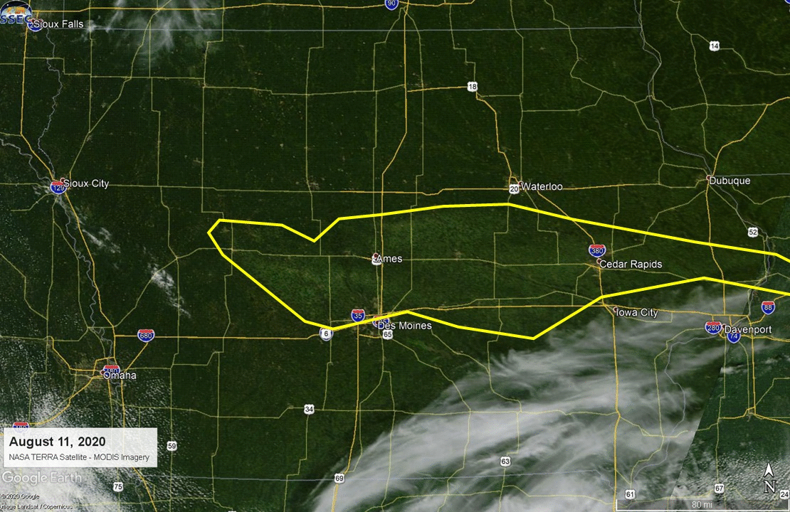 |
| NASA TERRA satellite MODIS imagery toggle between July 28, 2020 and August 11, 2020 showing the approximate damage to cropland (outlined) from the derecho that moved across Iowa on August 10, 2020. Imagery courtesy MODIS Today at University of Wisconsin-Madison Space Science and Engineering Center. |
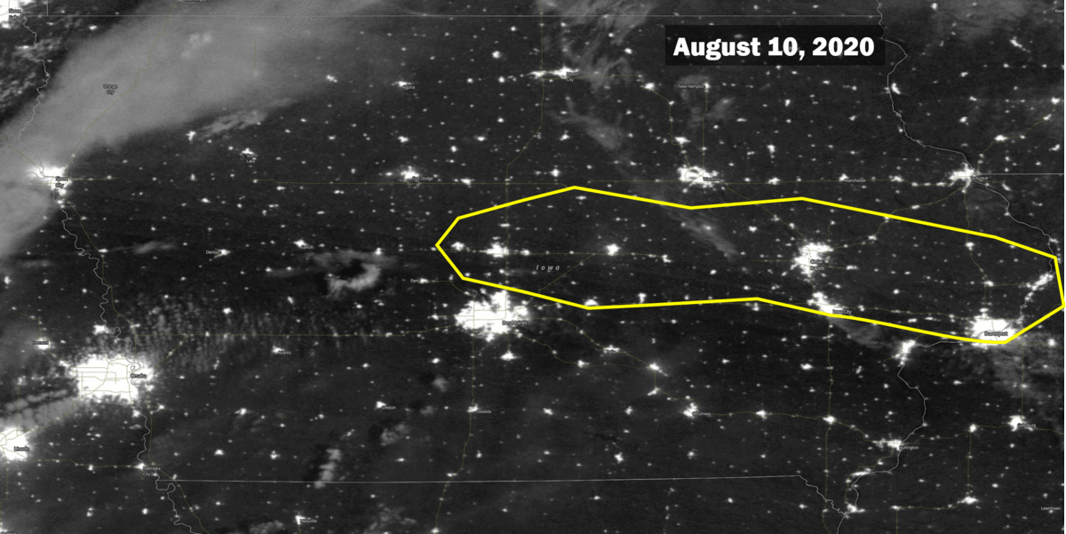 |
| NASA/NOAA Suomi Visible Infrared Imaging Radiometer Suite (VIIRS) Day/Night Band showing the nighttime lights in Iowa. The loop starts on the morning of August 10, 2020 before the derecho as a reference of nighttime lights in Iowa. The following images shows the progression from peak power outages on the morning of August 11 to the gradually and ongoing restoration on the mornings of the 12th, 14th, and 16th. Not all nights were cloudless so 'blurring' of lights may occur in some areas. Courtesy NASA Worldview. |
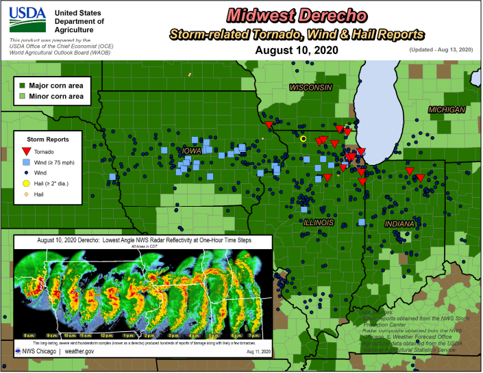 |
| USDA major/minor corn areas with NWS storm reports overlaid shows the derecho swept through major corn producing areas of Iowa, Illinois and Indiana on August 10, 2020. Courtesy of the USDA Weekly Weather and Crop Bulletin - August 18, 2020. |
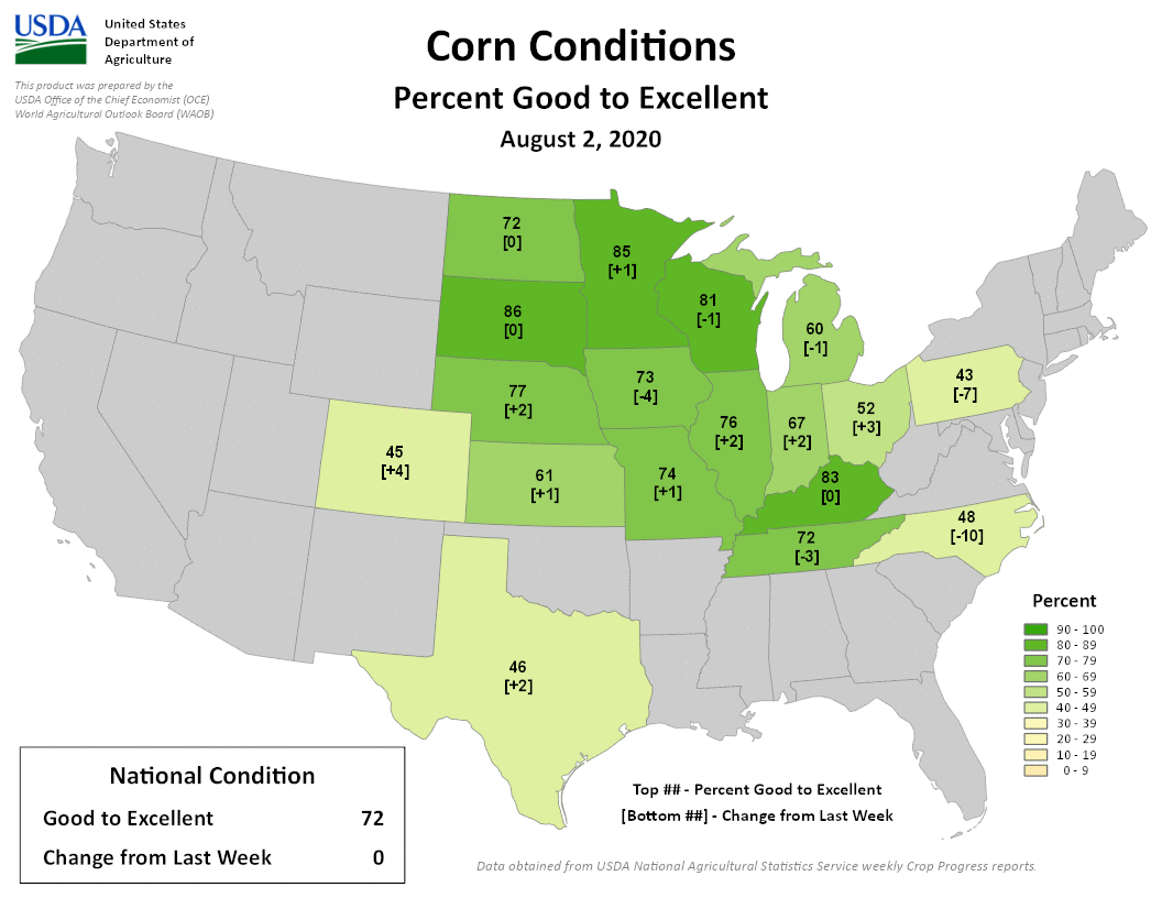 |
| Toggle between August 2, 16, and 23, 2020 showing a drop in the USDA Good to Excellent Corn Condition in Iowa. This drop in Iowa is a result of both the ongoing drought and the derecho. Data are from USDA-NASS Maps and are shared by Brad Rippey from USDA-Office of the Chief Economist World Agricultural Outlook Board. |
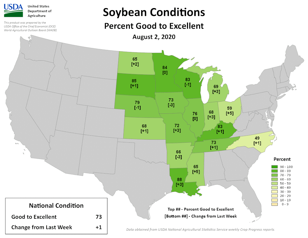 |
| Toggle between August 2, 16, and 23, 2020 showing a drop in the USDA Good to Excellent Soybean Condition in Iowa. This drop in Iowa is a result of both the ongoing drought and the derecho. Data are from USDA-NASS Maps and are shared by Brad Rippey from USDA-Office of the Chief Economist World Agricultural Outlook Board. |
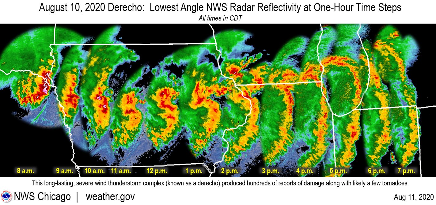 |
| Hourly radar images of the derecho's progression across the region. Image courtesy NWS Chicago (original). |
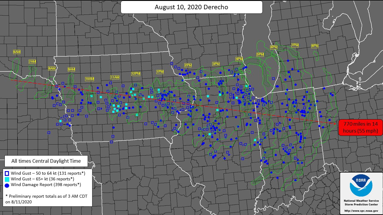 |
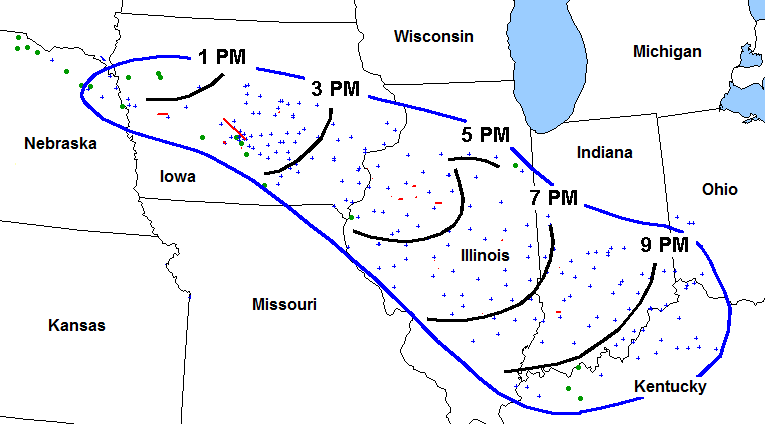
| Derecho's path across the region on August 10, 2020 was over 750 miles! Image courtesy NWS Storm Prediction Center (original). |
|
| Power outages caused as the derecho moved through Iowa into Indiana on August 10, 2020. Courtesy PowerOutage.us |
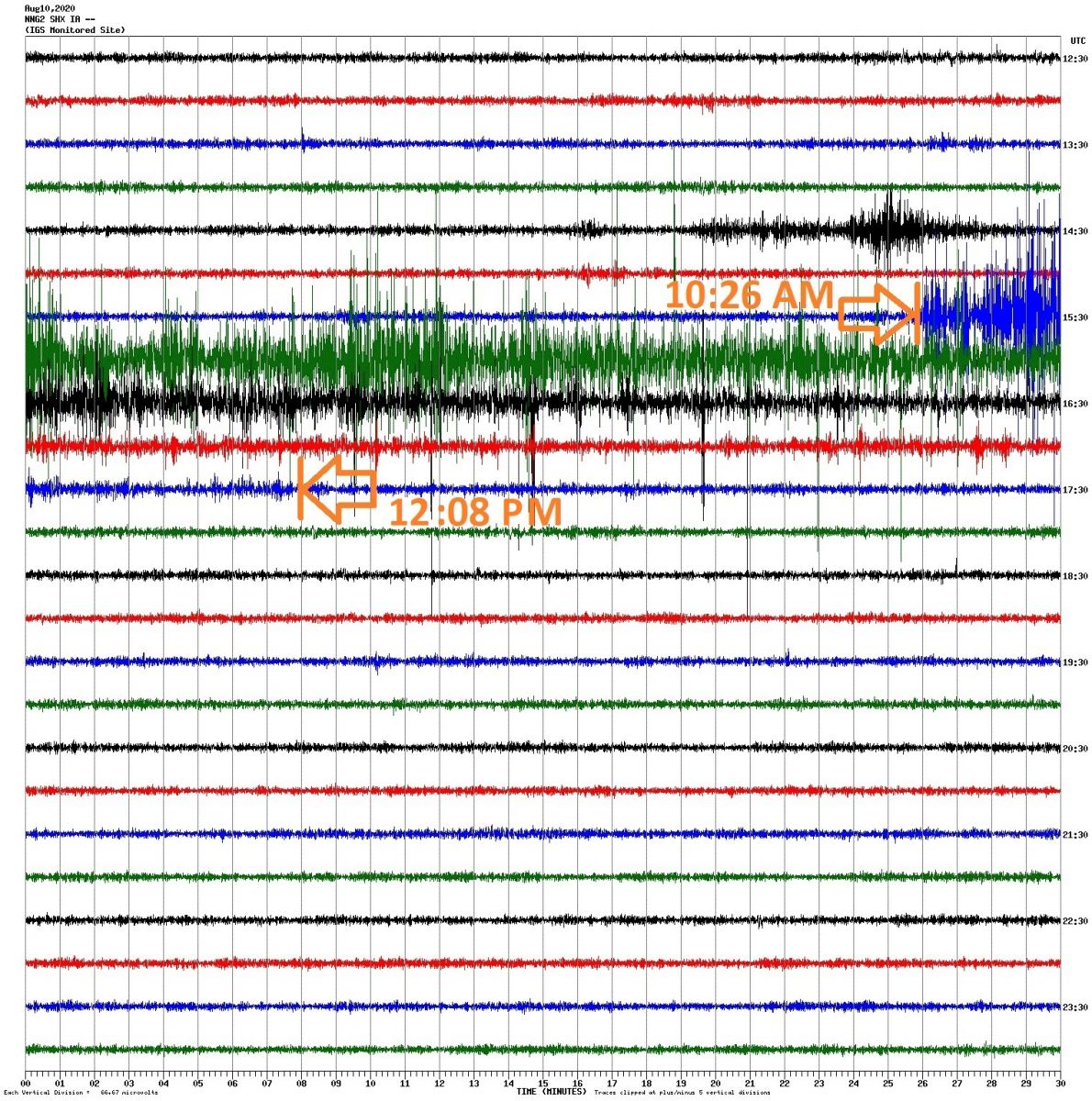 |
| Iowa Geological Survey's (IGS) real-time seismometer near Des Moines, IA captured the derecho as it moved through the metro. The IGS' Jason Vogelgesang says, "You can see the waveform responding to the immense wind, beginning at 10:26am & fading back to normal background conditions at 12:08pm". Each line represents 30 minutes of time from left to right and goes from 7am at the top of the image to 7pm at the bottom of the image. Original post on IGS Facebook page (note annotated time on their Facebook graphic corrected in the comments). Image courtesy Iowa Geological Survey. |
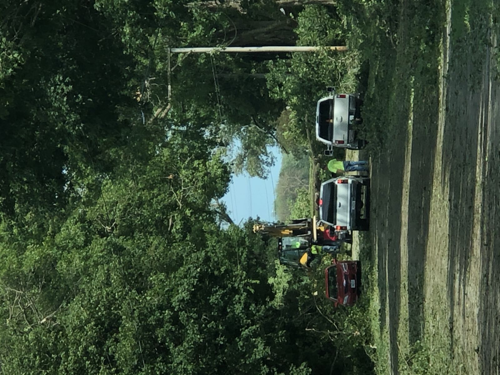
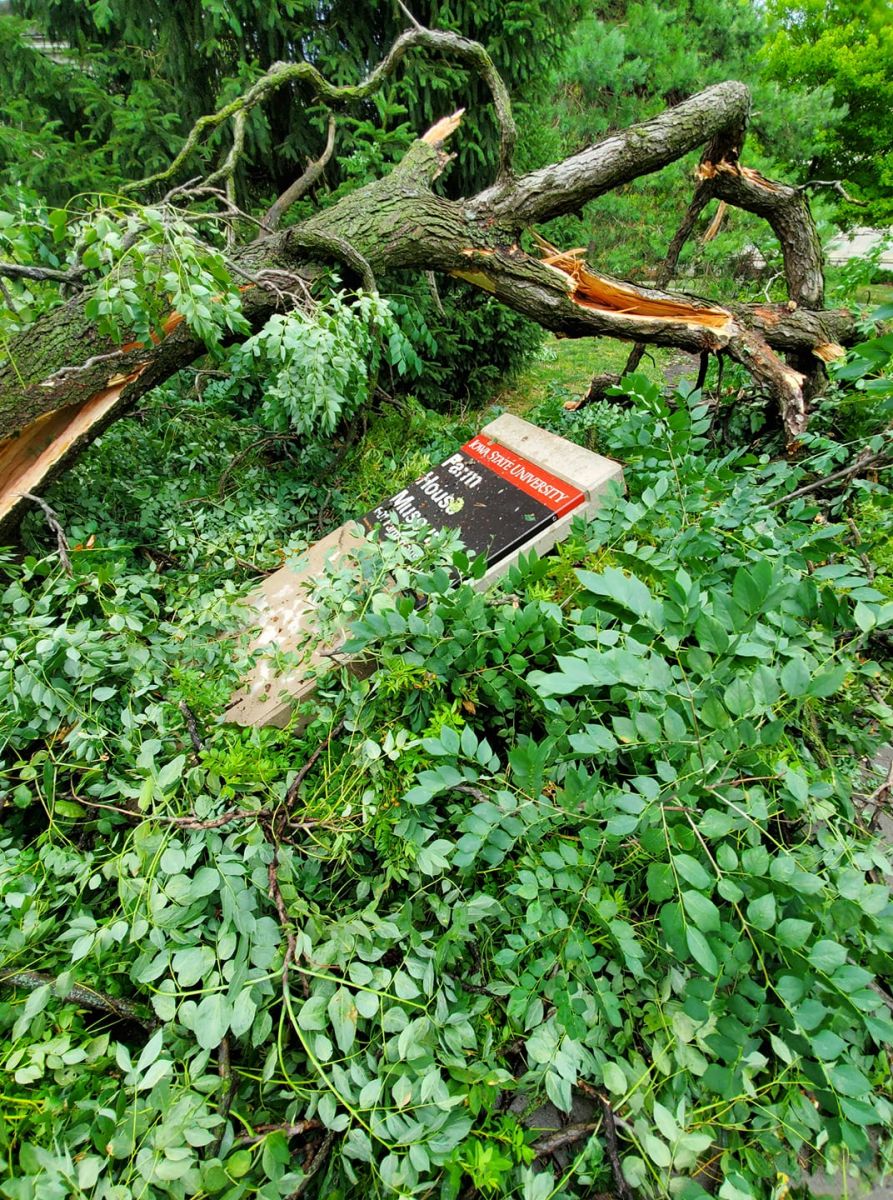
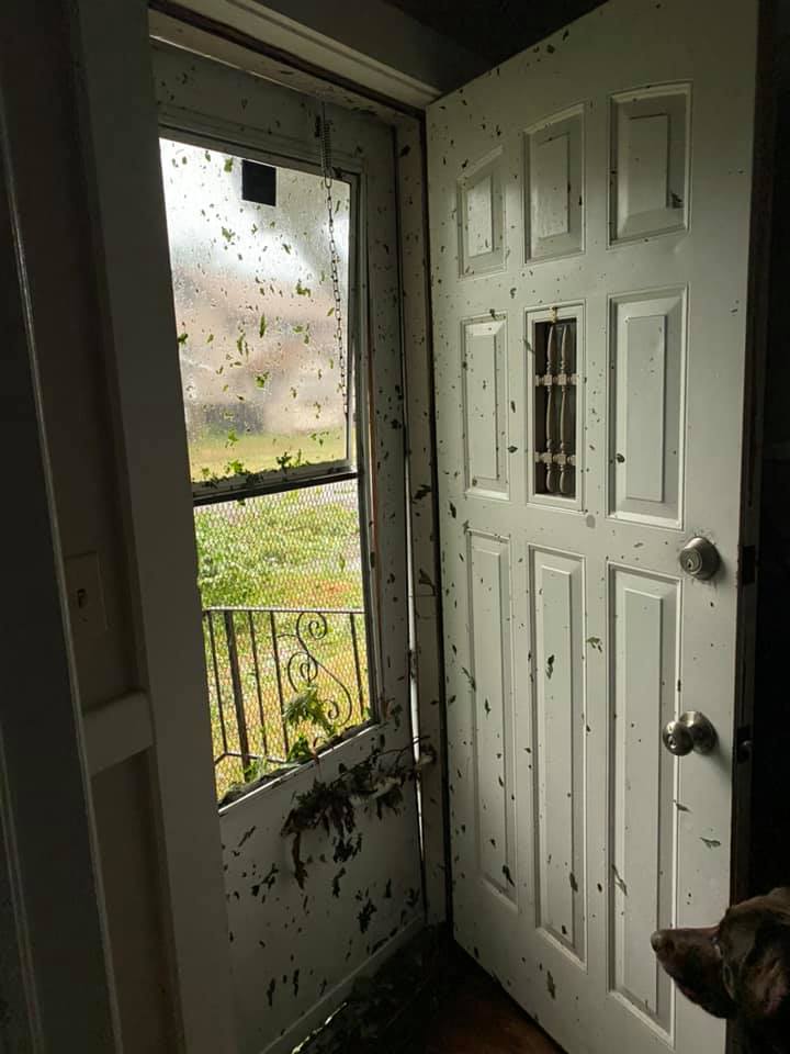
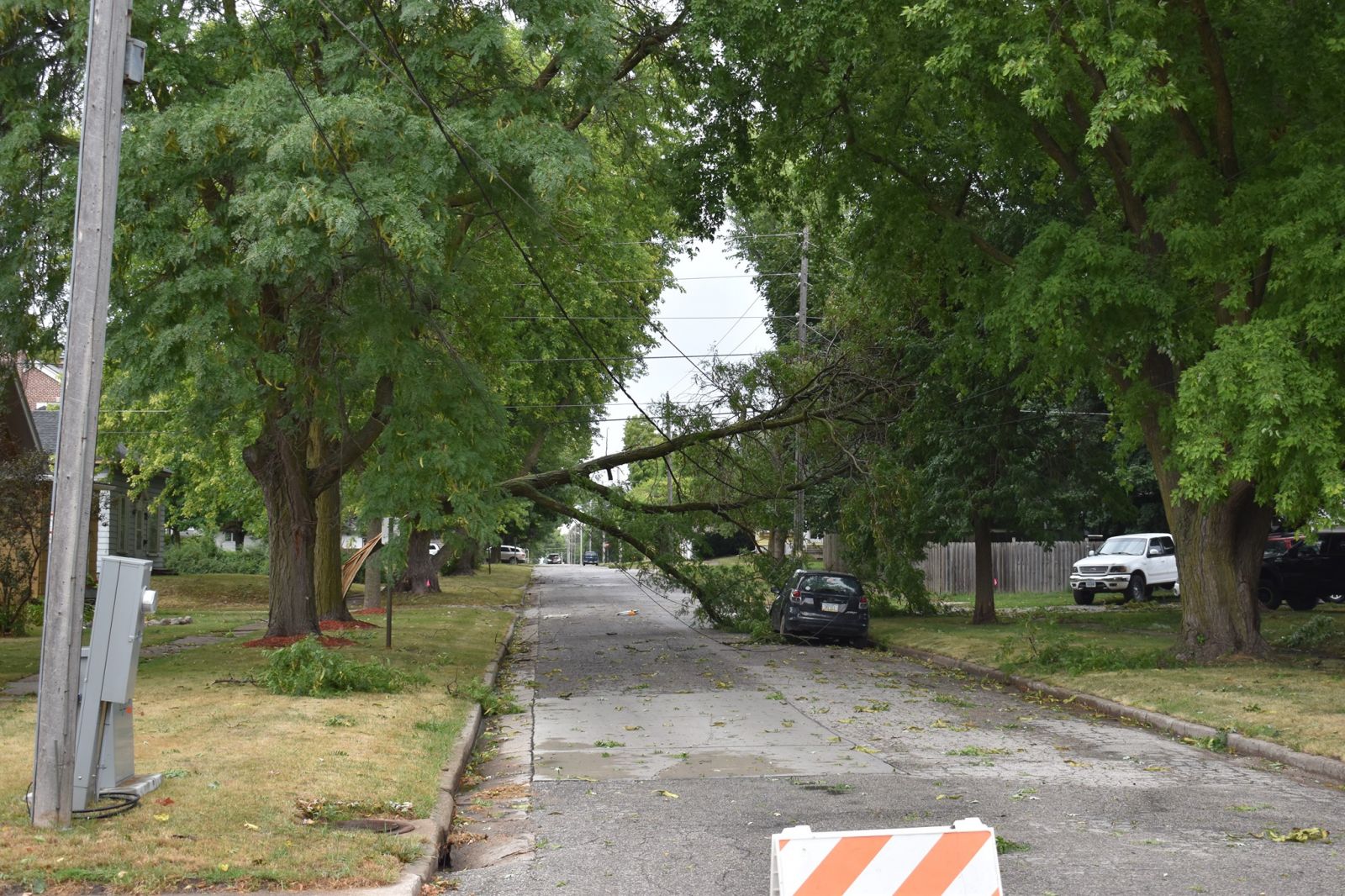
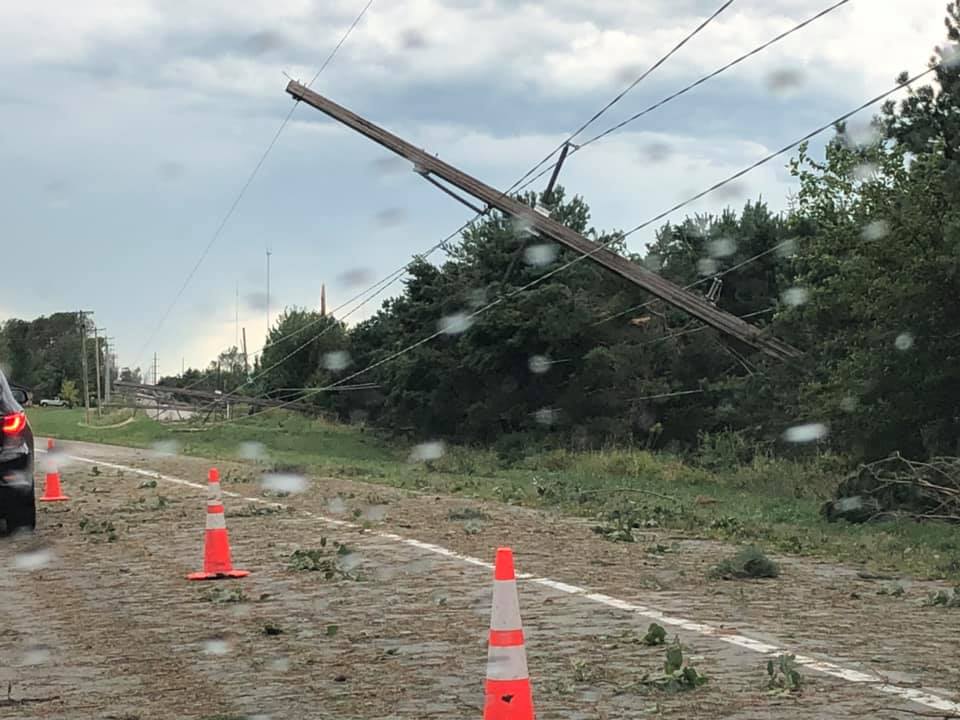
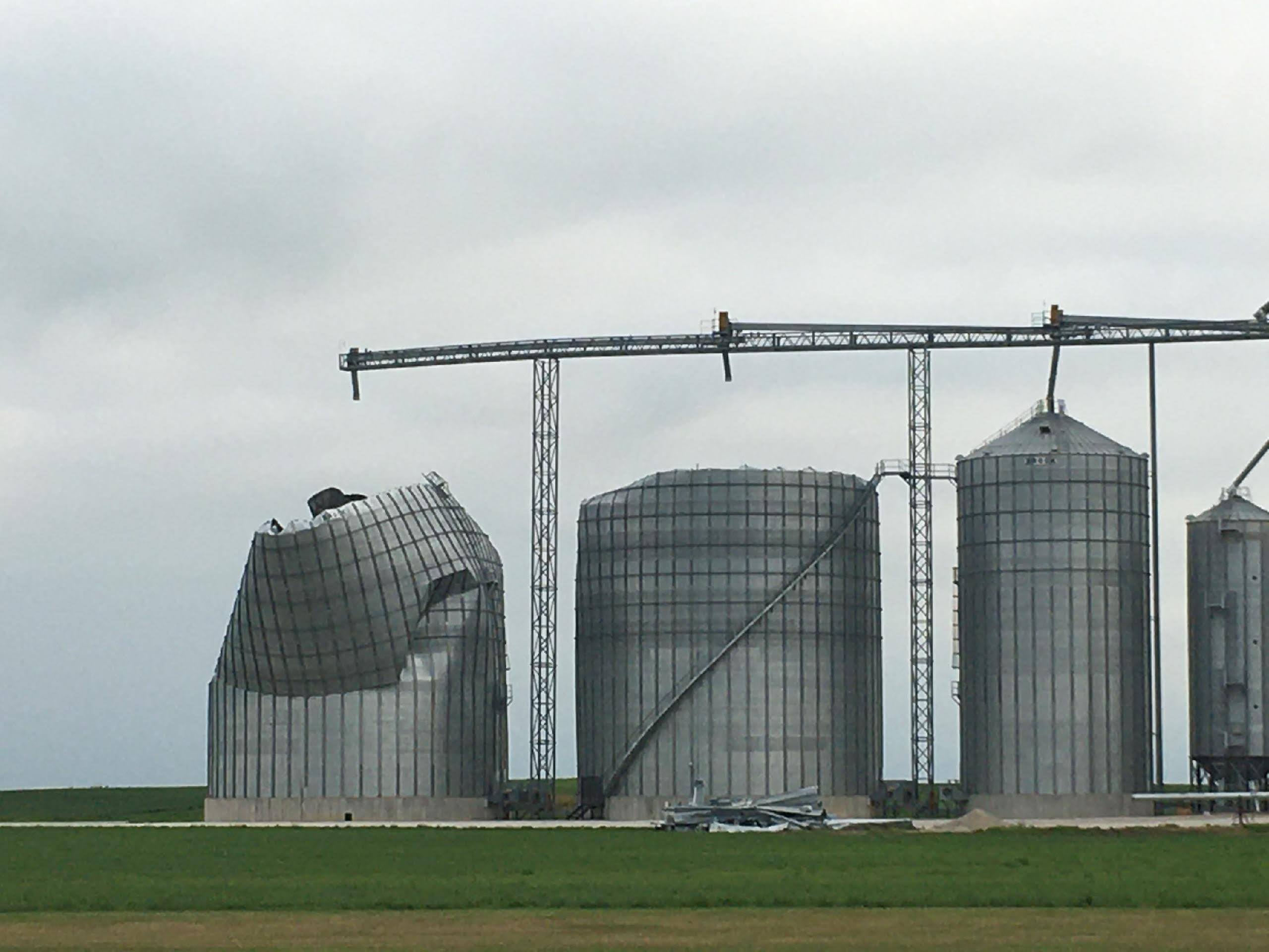
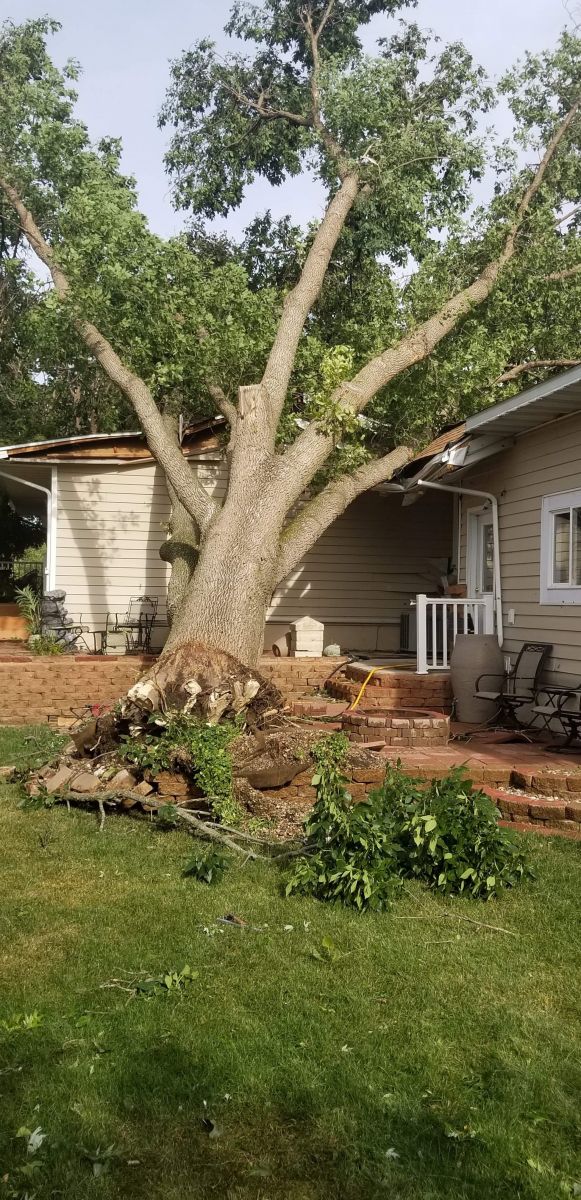
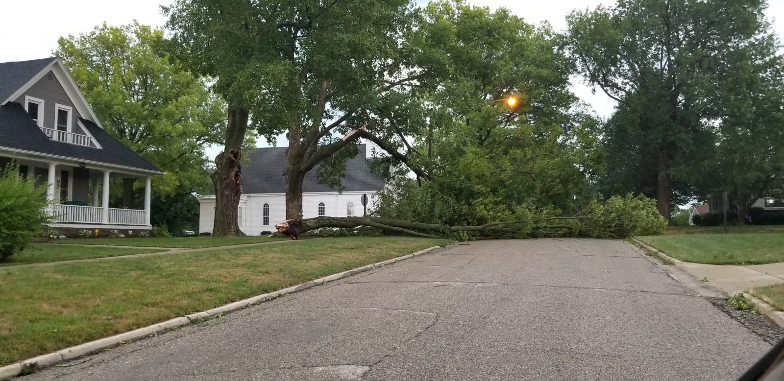
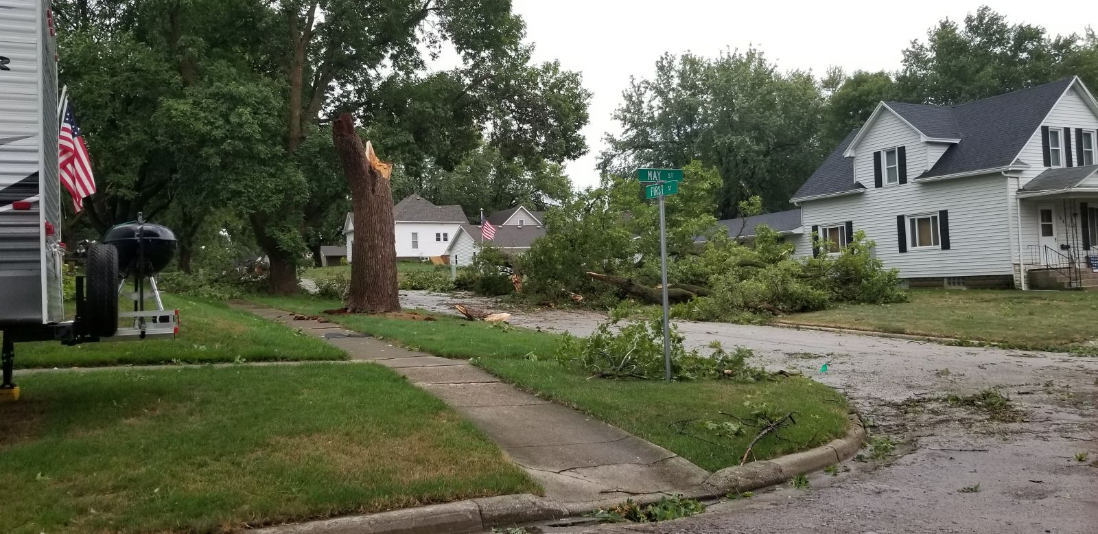
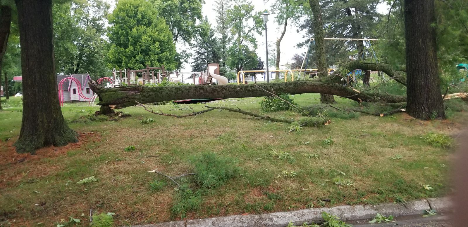
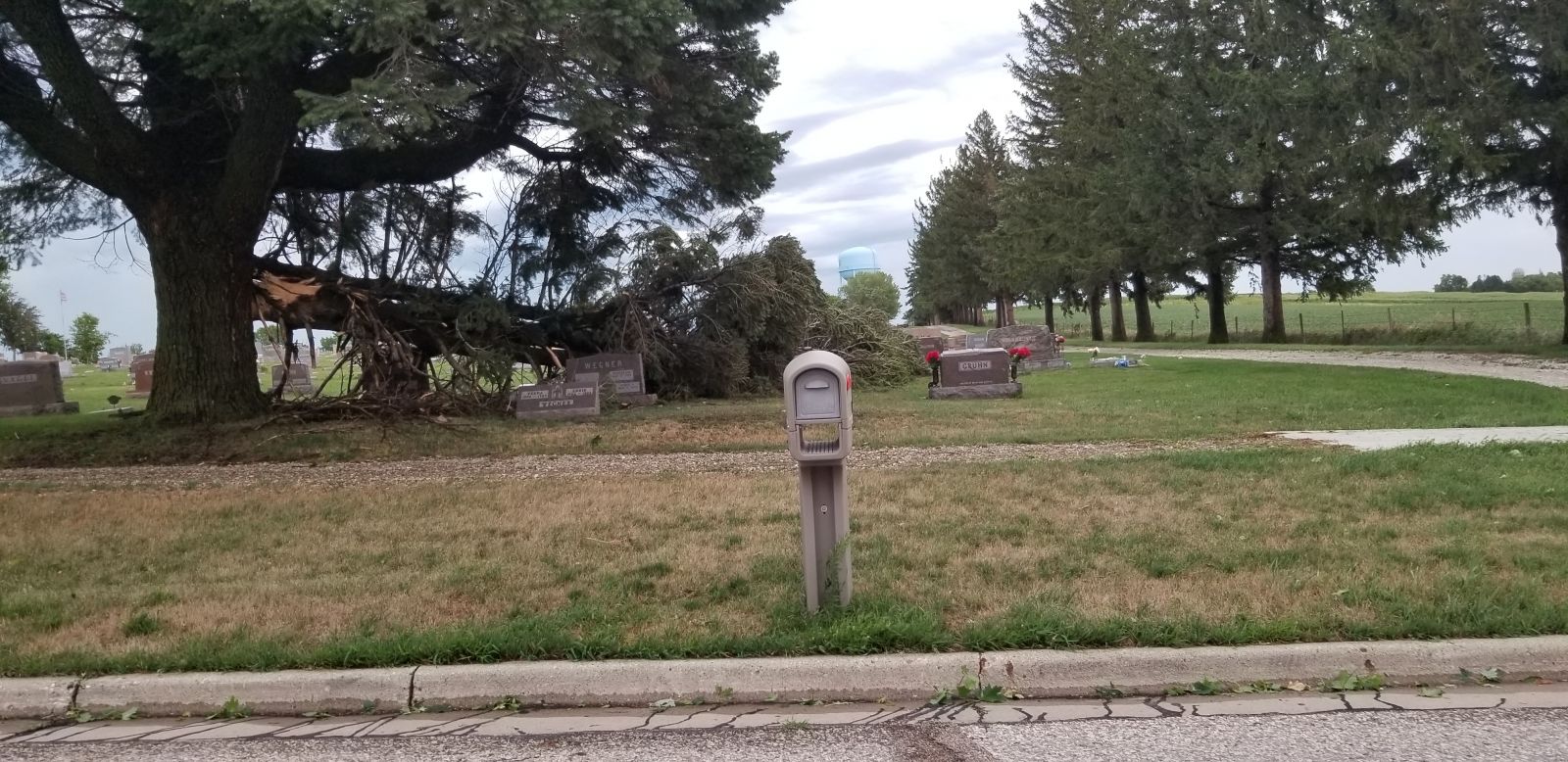
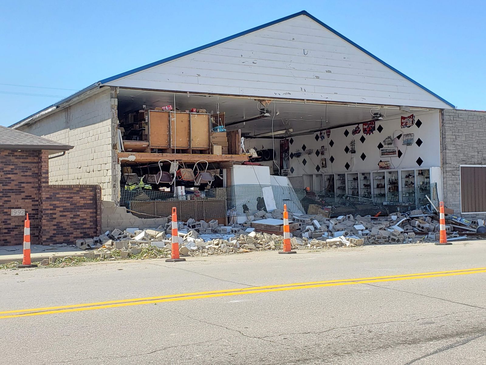
Photos
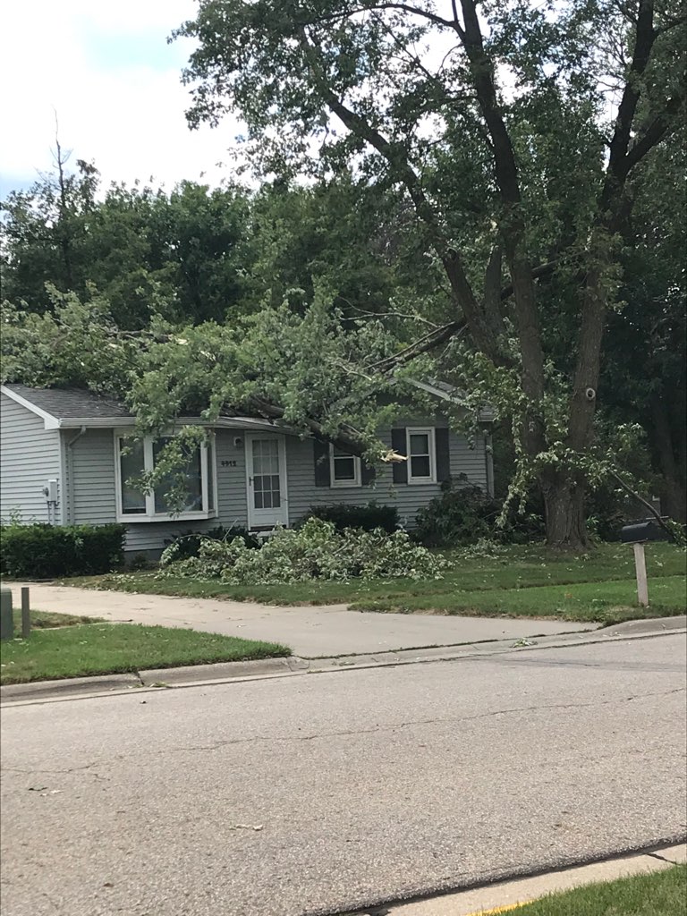
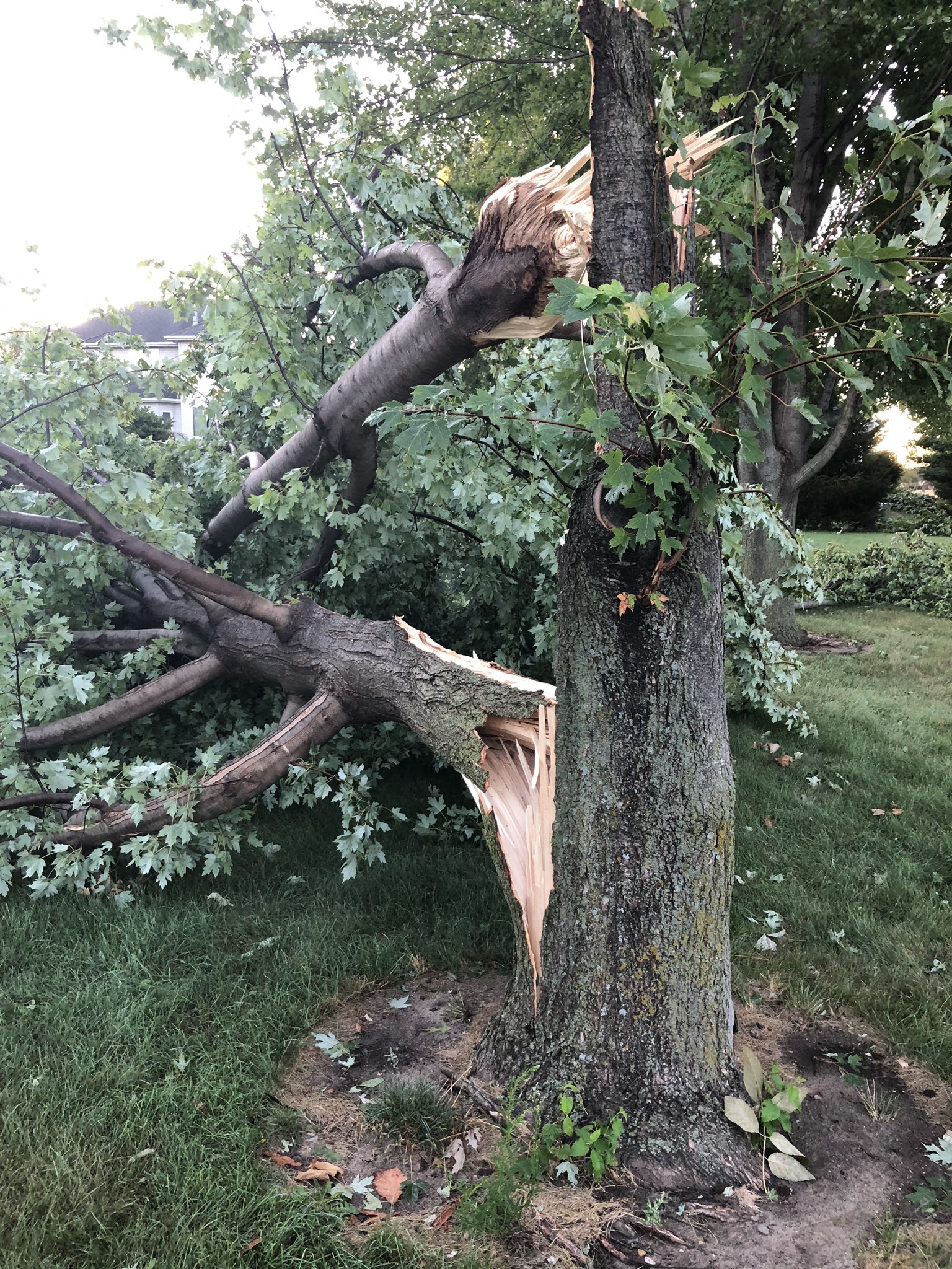
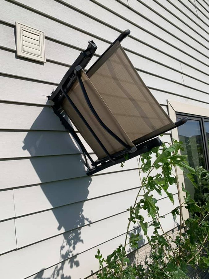
Photos from around central Iowa show the damage and devastation from the August 10, 2020 derecho
Additional photos/videos on this Twitter Moment
 |
|
 |
 |
| Defoliated soybeans south of Jefferson, IA (Courtesy Craig Cogil) |
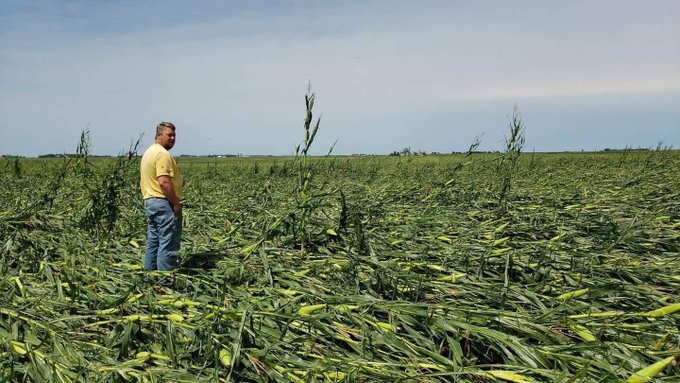
Flattened corn near Scranton, Iowa (Courtesy Mike Zevenbergen @MikeZevenbergen) |
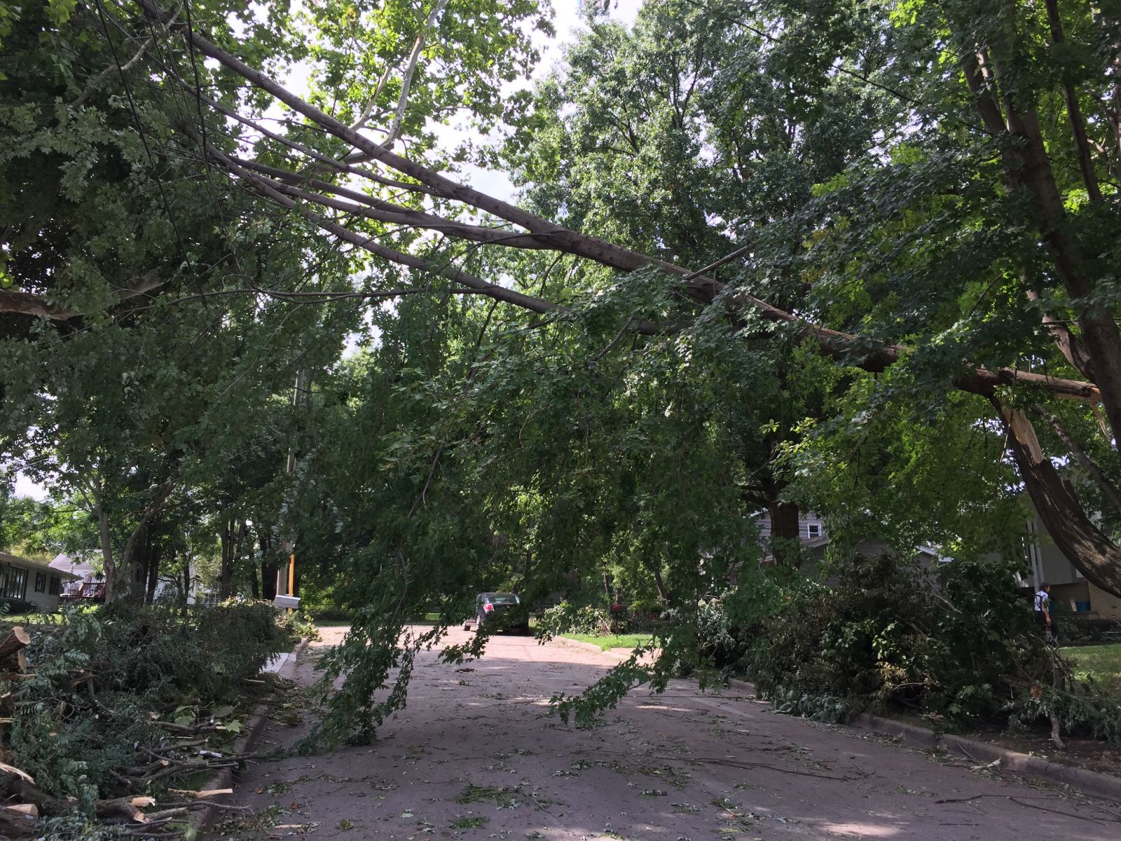
Broken tree limbs, Merle Hay neighborhood, Des Moines (courtesy NWS Des Moines) |
Broken tree hanging across road, Merle Hay neighborhood, Des Moines (courtesy NWS Des Moines) |
 |
 |
 |
 |
| Broken window, eastern Greene County, Iowa (Courtesy Megan Holz, @meganlholz) |
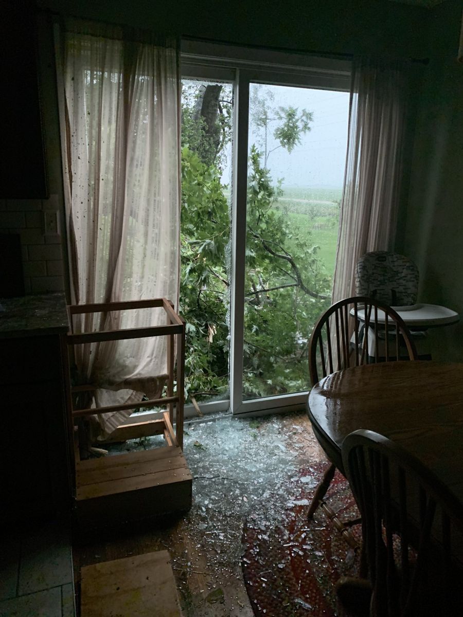
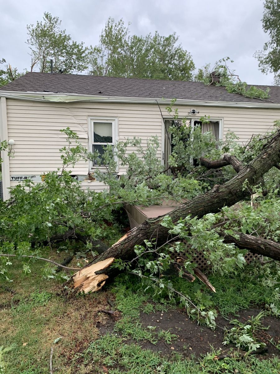
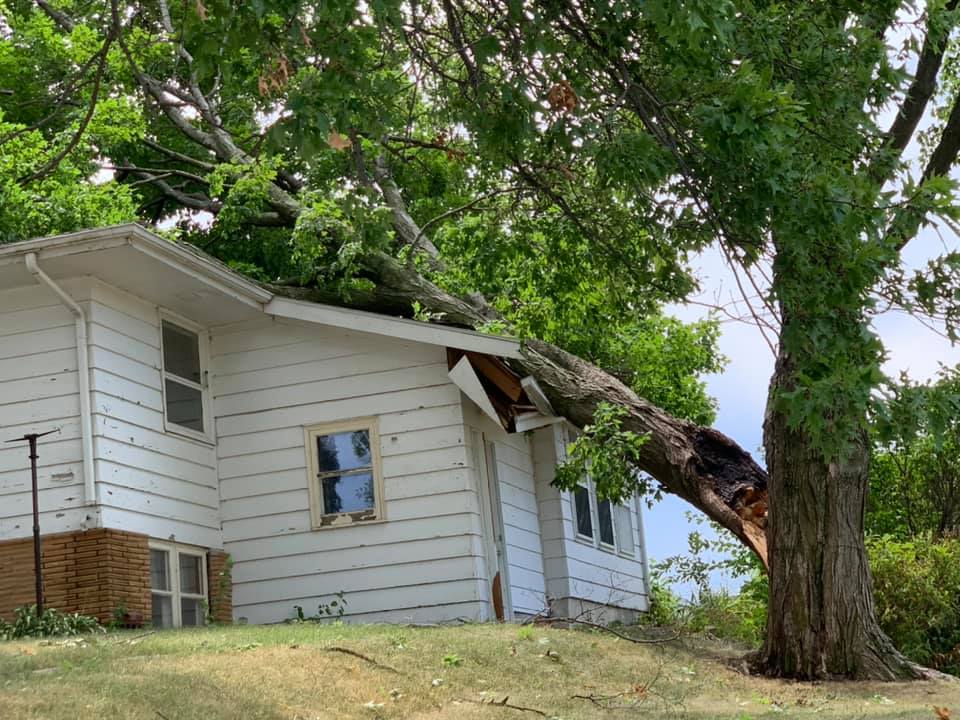
Tree into house and through sliding glass door, eastern Greene County, Iowa (Courtesy Megan Holz, @meganlholz) |
Toppled power lines, eastern Greene County, Iowa (Courtesy Megan Holz, @meganlholz) |
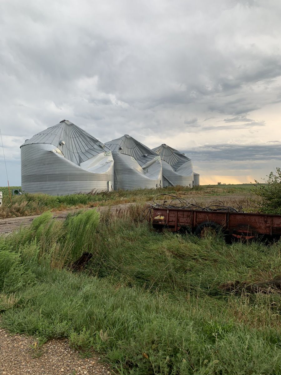
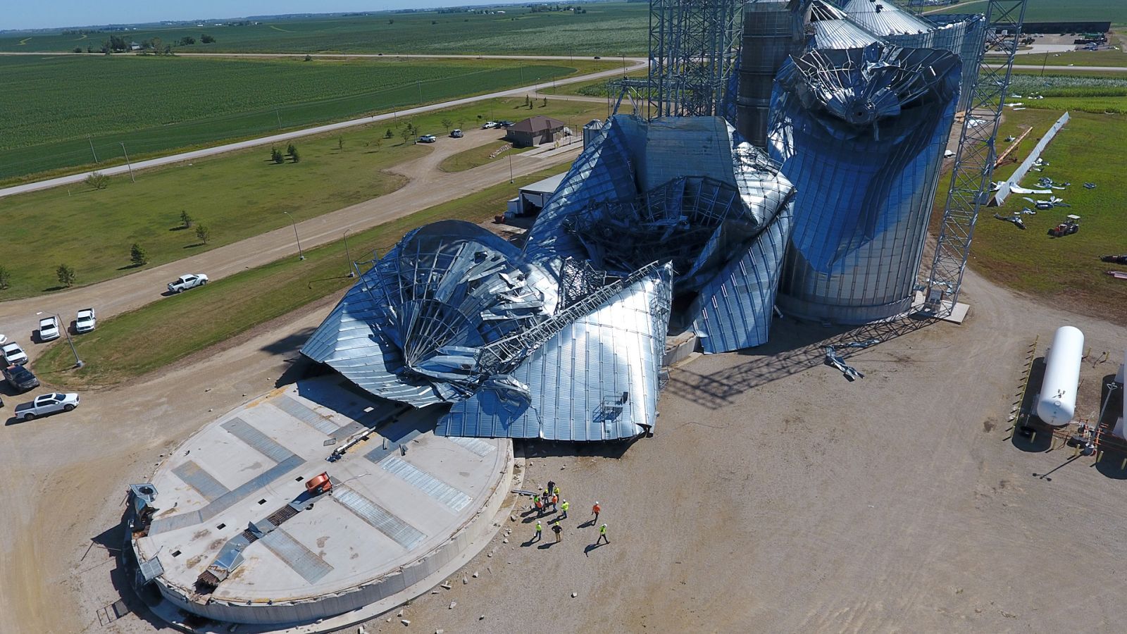
Damaged grain bins, eastern Greene County, Iowa (Courtesy Megan Holz, @meganlholz) |
 |
 |
 |
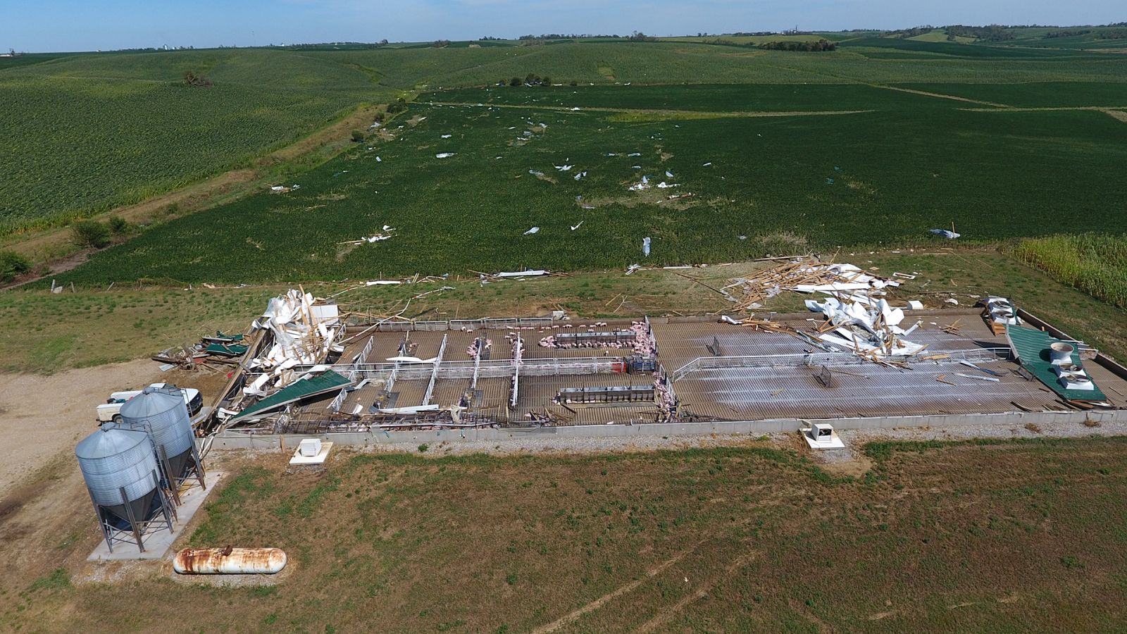 |
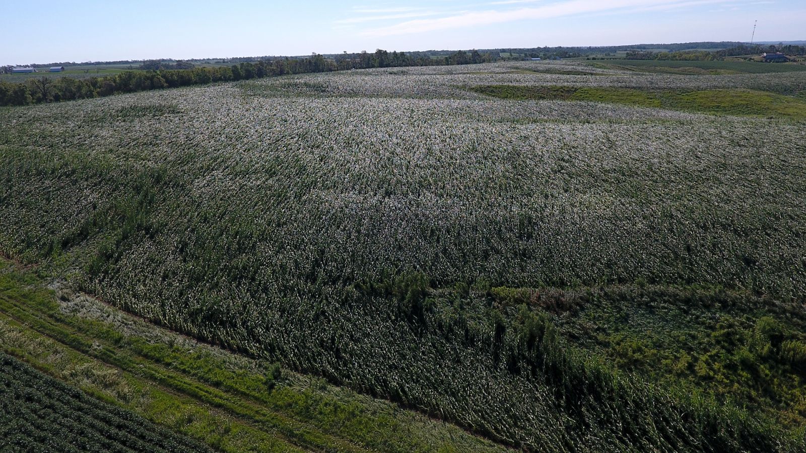
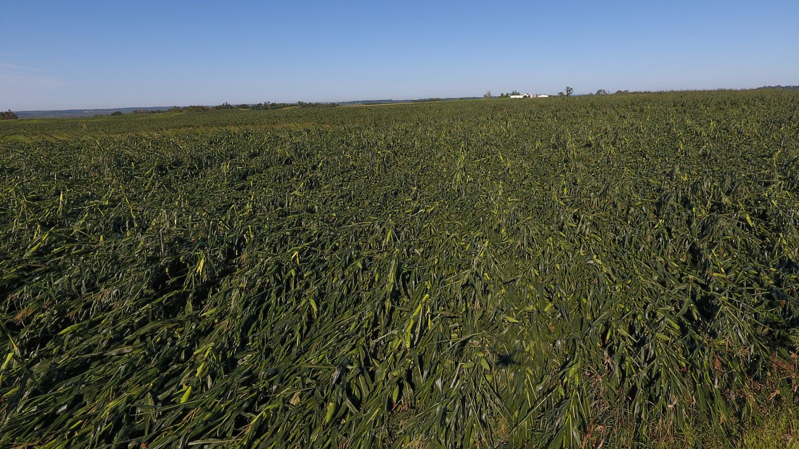
| Aerial view of the flattened corn in Tama County. (Courtesy of Kip Ladage) | Grain bins crushed in Tama County. (Courtesy of Kip Ladage) |
Flattened corn in Tama County. (Courtesy of Kip Ladage) | Hog confinement building demolished in Tama County. (Courtesy of Kip Ladage) |
|
|
|
 |
 |
| Roland, Iowa. (Courtesy of Angela Ruden) | Roland, Iowa. (Courtesy of Angela Ruden) | Elk Horn, Iowa. (Courtesy of Brandon Baggett) | Bondurant, Iowa. (Courtesy of Brennan Jontz) |
 |
 |
 |
 |
| Randall, Iowa (Courtesy Hamilton County Emergency Management) |
Randall, Iowa. (Courtesy of Hamilton County Emergency Management) | Farm House Museum. Iowa State University. (Courtesy of Allison Sheridan) | Marshalltown, Iowa. (Courtesy of Lindsay Cramer) |
 |
|
 |
 |
| Rockwell City, Iowa. (Courtesy of Randy VanEvery) | Perry, Iowa. (Courtesy of Rachel Lange) | Huxley, Iowa. (Courtesy of Chrystal Brillhart) | Damaged grain bin in Dallas County. (Courtesy of Dallas County Emergency Manager AJ Seely) |
 |
|
|
|
| Big tree on a house in Tama County (Courtesy of Darrell Ross) | West side of Ames, Iowa. (Courtesy NWS Des Moines) | Ames, Iowa. (Courtesy of City of Ames) | Ames, Iowa. (Courtesy Jason Mikkelsen) |
 |
 |
 |
 |
| Tree snapped at base in Manning, Iowa. (Courtesy of Amy Haskins) | Tree snapped in Manning. (Courtesy Amy Haskins) | Tree snapped at base in Manning, Iowa. (Courtesy of Amy Haskins) | Broken tree branch in Manning, Iowa. (Courtesy of Amy Haskins) |
.jpg) |
.jpg) |
 |
 |
| Flattened corn at sunset near Adel, Iowa. (Courtesy of Lisa Schmitz) | Flattened corn near Bouton, Iowa. (Courtesy Lisa Schmitz) | Building damaged in Woodward, Iowa (Courtesy of AJ Seely, Dallas County Emergency Management) | Tipped over livestock semi at a gas station on Highway 141 and 169.(Courtesy of AJ Seely, Dallas County Emergency Managment) |
Videos
Video from Huxley, Iowa. Courtesy of Jeff Wood.
Video from Dysart, Iowa. Courtesy of Chad Spore.
Video from Ankeny, Iowa. Courtesy of Jared Flater.
Video from Huxley, Iowa. Courtesy of Nick Glenn.
Video from Boone, Iowa. Courtesy of Jake Randolph.
Video from Kiron, Iowa. Courtesy of Kelli Fineran.
Radar & Satellite
 |
| Multi-Radar Multi-Sensor animation of the derecho's path through Iowa from 4am to 4pm on August 10, 2020. |
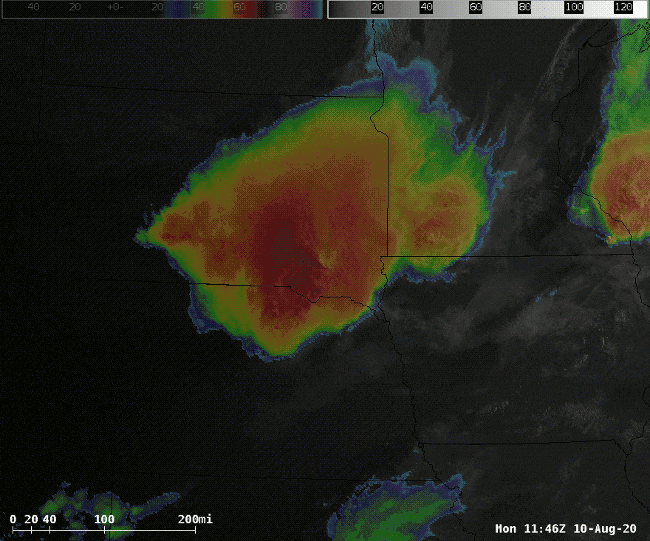 |
| GOES-East Sandwich (blend of visible and infrared) loop (Courtesy William Churchill, NWS) |
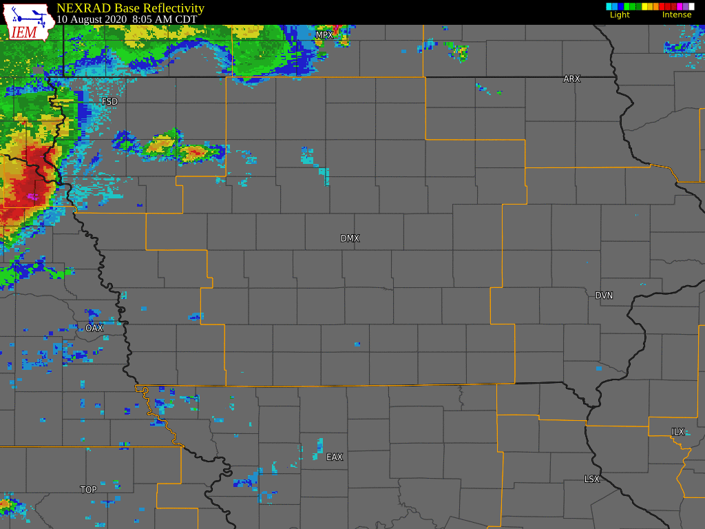 |
| Radar loop from the Iowa Environmental Mesonet of the derecho's progression across Iowa from 8am to 2pm on August 10, 2020. Courtesy of the Iowa Environmental Mesonet. |
Satellite Blog DiscUssions
Research Article(s)
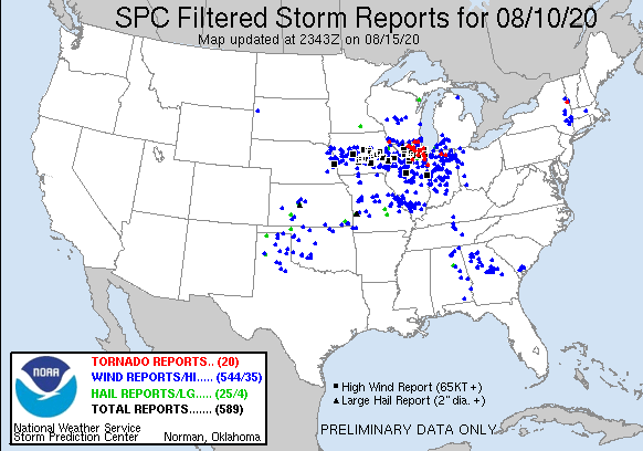
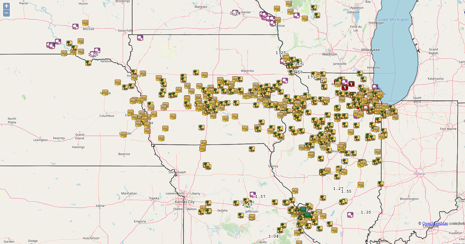
Storm Reports
 |
|
| SPC Storm Reports from August 10, 2020 Interactive Map - Storm Prediction Center |
Iowa Environmental Mesonet Local Storm Reports Map |
 |
|
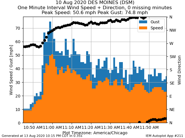
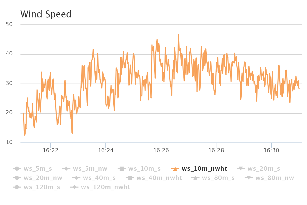
| One minute wind observations at the Des Moines International Airport (KDSM) on August 10, 2020 in the late morning showing a wind gust of 75 mph with wind gusts over 50 mph for over 20 minutes. Image courtesy of the Iowa Environmental Mesonet. Full feature can be viewed here. | Iowa Atmospheric Observatory Tall Tower, located near Zearing, Iowa, shows a maximum, instantaneous 10 meter wind speed max of 46.71 m/s, which is 104 mph, at 11:26.38. Not shown, but at 80m, which is the typical hub height of a wind turbine, the maximum, instantaneous wind speed was 53.88 m/s, which is 120 mph, at 11:26.37. Wind gusts for storm reports are 5 second averages versus instantaneous gusts. Image courtesy of the Iowa Environmental Mesonet. You can view the data here. |
Iowa Environmental Mesonet - Derecho Peak Wind Gusts (variety of automated weather stations) and a listing of local storm reports from across Iowa.
Text Summary of Storm Reports - Issued August 10, 2020 at 316pm CDT
PRELIMINARY LOCAL STORM REPORT...SUMMARY
NATIONAL WEATHER SERVICE DES MOINES IA
316 PM CDT MON AUG 10 2020
..TIME... ...EVENT... ...CITY LOCATION... ...LAT.LON...
..DATE... ....MAG.... ..COUNTY LOCATION..ST.. ...SOURCE....
..REMARKS..
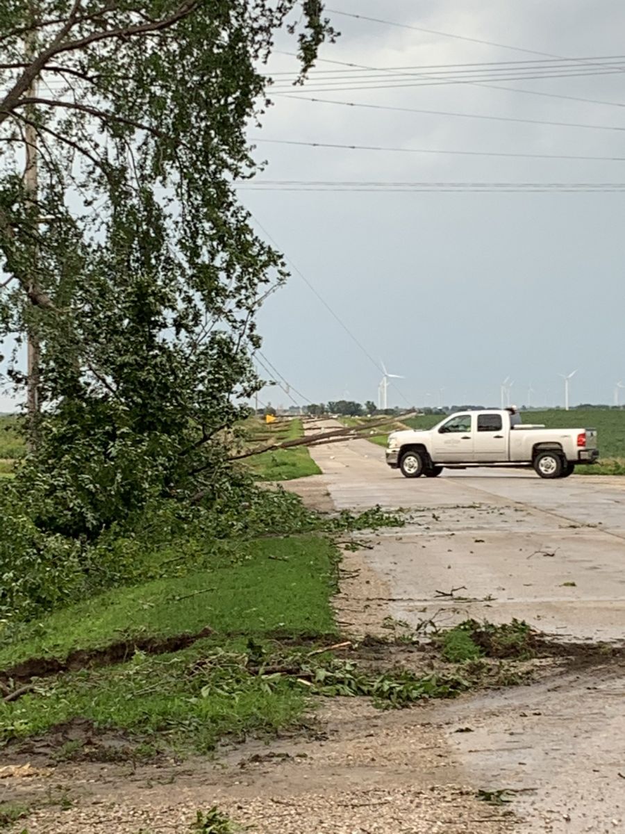
0930 AM TSTM WND DMG DENISON 42.02N 95.35W
08/10/2020 CRAWFORD IA LAW ENFORCEMENT
LAW REPORTS TREE DAMAGE IN TOWN - TREE FELL
ON NEIGHBORS CAR. TREE DAMAGE THROUGHOUT THE
COUNTY. TIME ESTIMATED.
0930 AM TSTM WND DMG KIRON 42.19N 95.33W
08/10/2020 CRAWFORD IA LAW ENFORCEMENT
SEMI JACKKNIFED DUE TO STRONG WINDS.
0936 AM TSTM WND DMG MANNING 41.91N 95.06W
08/10/2020 CARROLL IA TRAINED SPOTTER
LARGE TREE LIMB ROUGHLY 6 INCHES IN DIAMETER
AND 20 FEET LONG DOWN. SEVERAL SMALLER TREE
LIMBS DOWN AS WELL.
0945 AM TSTM WND DMG BUCK GROVE 41.92N 95.40W
08/10/2020 CRAWFORD IA LAW ENFORCEMENT
TREE DAMAGE REPORTED AROUND TOWN.
1000 AM TSTM WND DMG 3 WSW BAGLEY 41.83N 94.49W
08/10/2020 GUTHRIE IA EMERGENCY MNGR
OUTBUILDING HAD ROOF BLOWN OFF. TIME
ESTIMATED.
1002 AM TSTM WND GST 3 WSW GLIDDEN 42.05N 94.79W
08/10/2020 M74 MPH CARROLL IA AWOS
1010 AM TSTM WND GST 4 SSE ATLANTIC 41.34N 95.00W
08/10/2020 E60 MPH CASS IA PUBLIC
1014 AM TSTM WND GST 5 SSE GUTHRIE CENTER 41.61N 94.45W
08/10/2020 M65 MPH GUTHRIE IA MESONET
1015 AM TSTM WND DMG TEMPLETON 41.92N 94.94W
08/10/2020 CARROLL IA TRAINED SPOTTER
LARGE TREES DOWN BLOCKING ROADS. WIND STILL
BLOWING.
1021 AM TSTM WND GST 4 WSW BAGLEY 41.82N 94.49W
08/10/2020 E65 MPH GUTHRIE IA EMERGENCY MNGR
ALONG WITH PEA SIZED HAIL AND HEAVY
RAINFALL.
1025 AM TSTM WND DMG PERRY 41.84N 94.10W
08/10/2020 DALLAS IA EMERGENCY MNGR
TWO FOOT DIAMETER TREE LIMB DOWN IN PERRY.
1026 AM TSTM WND GST 1 N PERRY 41.86N 94.10W
08/10/2020 E70 MPH DALLAS IA PUBLIC
BRANCHES DOWN, POWER OUT.
1030 AM TSTM WND DMG 1 ESE MARSHALLTOWN 42.03N 92.89W
08/10/2020 MARSHALL IA EMERGENCY MNGR
ROOF DAMAGE TO A HOME. TIME ESTIMATED.
1030 AM TSTM WND GST CHURDAN 42.16N 94.48W
08/10/2020 E70 MPH GREENE IA TRAINED SPOTTER
DEBRIS ON ROADS AS WELL.
1032 AM TSTM WND DMG 7 NW ADEL 41.68N 94.12W
08/10/2020 DALLAS IA TRAINED SPOTTER
LARGE TREE LIMB DOWN HIT HOUSE. WITHOUT
POWER NOW. ESTIMATE 60 MPH WINDS OR HIGHER.
1033 AM TSTM WND GST 2 WSW MINBURN 41.75N 94.06W
08/10/2020 E70 MPH DALLAS IA FIRE DEPT/RESCUE
60 TO 70 MPH WIND GUSTS.
1034 AM TSTM WND DMG GUTHRIE CENTER 41.68N 94.50W
08/10/2020 GUTHRIE IA TRAINED SPOTTER
TREES DOWN. WIND STILL BLOWING.
1034 AM TSTM WND DMG ROCKWELL CITY 42.40N 94.63W
08/10/2020 CALHOUN IA TRAINED SPOTTER
8 INCH TREE LIMBS DOWN. POWER LINES DOWN.
TREES DOWN ALL OVER TOWN.
1037 AM TSTM WND GST 2 SE ADEL 41.59N 94.00W
08/10/2020 E65 MPH DALLAS IA PUBLIC
POWER OFF/ON. WINDS HIGHER THAN 60 MPH.
1038 AM TSTM WND GST 2 WSW PILOT MOUND 42.15N 94.05W
08/10/2020 E65 MPH BOONE IA TRAINED SPOTTER
TREE DAMAGE REPORTED. WINDS GREATER THAN 60
MPH ESTIMATED.
1040 AM TSTM WND GST 4 WNW DE SOTO 41.55N 94.08W
08/10/2020 E70 MPH DALLAS IA TRAINED SPOTTER
LOTS OF SMALL TREES DOWN AND SEVERAL
ANCHORED SWING SETS TOPPLED OVER.
1047 AM TSTM WND GST 1 WSW WEST DES MOINES 41.56N 93.78W
08/10/2020 E70 MPH POLK IA TRAINED SPOTTER
MILLS CIVIC AND I35; 70 MPH WINDS. SIGN AND
TREE DAMAGE. WINDS OF 55 TO 70 LASTED NEARLY
20 MINUTES DURING THE SURGE.
1048 AM TSTM WND GST ADEL 41.62N 94.03W
08/10/2020 M70 MPH DALLAS IA TRAINED SPOTTER
WIND REPORTED IN CITY OF ADEL. LIMBS DOWN,
OBJECTS BLOWN AROUND.
1052 AM TSTM WND DMG 3 ESE BOONE 42.03N 93.82W
08/10/2020 BOONE IA PUBLIC
SEMI BLOWN OVER AT US30/HIGHWAY 17
INTERCHANGE. TIME ESTIMATED BY RADAR.
1054 AM TSTM WND DMG 2 W MURRAY 41.04N 93.98W
08/10/2020 CLARKE IA TRAINED SPOTTER
DAMAGE TO HOME FOUNDATION AND SEVERAL LARGE
TREE LIMBS DOWN AS WELL AS VERY LARGE TREE
TRUNK.
1054 AM TSTM WND DMG LUTHER 41.97N 93.82W
08/10/2020 BOONE IA TRAINED SPOTTER
SEVERAL LARGE TREE LIMBS DOWN, POWER OUT.
1055 AM TSTM WND GST 5 WSW CUMMING 41.45N 93.84W
08/10/2020 E75 MPH MADISON IA TRAINED SPOTTER
1055 AM TSTM WND DMG 5 NW LOHRVILLE 42.31N 94.63W
08/10/2020 CALHOUN IA TRAINED SPOTTER
TREES DOWN, ROOF OFF BUILDING. LOTS OF TREE
DAMAGE.
1056 AM TSTM WND DMG CUMMING 41.48N 93.76W
08/10/2020 WARREN IA PUBLIC
POWER OUT NEAR CUMMING, IOWA.
1057 AM TSTM WND DMG BOONE 42.05N 93.88W
08/10/2020 BOONE IA PUBLIC
POWER OUT, TREES DOWN.
1059 AM TSTM WND DMG 1 N WINDSOR HEIGHTS 41.63N 93.71W
08/10/2020 POLK IA PUBLIC
REPORTED AT 75TH AND DIAMOND, URBANDALE IOWA
TREE DAMAGE.
1100 AM TSTM WND DMG 1 N BONDURANT 41.70N 93.46W
08/10/2020 POLK IA TRAINED SPOTTER
NUMEROUS TREES AND POWERLINES DOWN. TIME
ESTIMATED.
1100 AM TSTM WND GST 1 W URBANDALE 41.64N 93.77W
08/10/2020 M85 MPH POLK IA TRAINED SPOTTER
REPORTED AT 112TH NE AND 104TH, DES MOINES
FROM PERSONAL WEATHER STATION. TIME
ESTIMATED.
1100 AM TSTM WND GST 1 N DES MOINES INT AIRP 41.55N 93.66W
08/10/2020 E80 MPH POLK IA TRAINED SPOTTER
SEVERAL LARGE TREE LIMBS DOWN AND A COUPLE
TREE TRUNKS SNAPPED. ROADS BLOCKED.
1100 AM TSTM WND DMG 1 ESE MARSHALLTOWN 42.03N 92.89W
08/10/2020 MARSHALL IA PUBLIC
100 TO 120 CARS HAD THEIR WINDOWS BLOWN OUT
AT A FACTORY. TIME ESTIMATED.
1101 AM TSTM WND GST 3 NE ANKENY 41.76N 93.57W
08/10/2020 M69 MPH POLK IA MESONET
MESONET STATION RAKI4 ANKENY - I35 AND NE
36TH.
1102 AM TSTM WND DMG FORT DODGE 42.51N 94.18W
08/10/2020 WEBSTER IA EMERGENCY MNGR
NUMEROUS TREES DOWN ALONG WITH POWER
OUTAGES.
1103 AM TSTM WND DMG CUMMING 41.48N 93.76W
08/10/2020 WARREN IA TRAINED SPOTTER
SEVERAL LARGE TREES DOWN THROUGHOUT THE TOWN
OF CUMMING. TIME ESTIMATED BY RADAR.
1103 AM TSTM WND GST INDIANOLA 41.36N 93.56W
08/10/2020 M58 MPH WARREN IA PUBLIC
1104 AM TSTM WND GST DES MOINES INT AIRPORT 41.53N 93.67W
08/10/2020 M75 MPH POLK IA ASOS
ASOS STATION KDSM DES MOINES INTERNATIONAL
AIRPORT.
1105 AM TSTM WND DMG 1 NNW WINDSOR HEIGHTS 41.62N 93.72W
08/10/2020 POLK IA PUBLIC
ROOF DAMAGE TO BUCCANEER ARENA. 72ND AND
HICKMAN RD. REPORT VIA SOCIAL MEDIA. TIME
ESTIMATED.
1105 AM TSTM WND DMG 3 S SAYLORVILLE 41.64N 93.63W
08/10/2020 POLK IA TRAINED SPOTTER
TWELVE INCH TO EIGHT INCH DIAMETER TREES
DOWN.
1106 AM TSTM WND GST 1 E CLIVE 41.61N 93.75W
08/10/2020 E70 MPH POLK IA NWS EMPLOYEE
LOTS OF SMALL BRANCHES DOWN.
1106 AM TSTM WND GST MADRID 41.87N 93.81W
08/10/2020 M59 MPH BOONE IA MESONET
MESONET STATION CW2001 MADRID.
1107 AM TSTM WND GST GILBERT 42.11N 93.65W
08/10/2020 E70 MPH STORY IA TRAINED SPOTTER
1110 AM TSTM WND GST 3 ENE AMES 42.03N 93.57W
08/10/2020 M62 MPH STORY IA MESONET
MESONET STATION RAMI4 2 E AMES.
1110 AM TSTM WND DMG 1 W JOHNSTON 41.68N 93.75W
08/10/2020 POLK IA NWS EMPLOYEE
NW JOHNSTON TREE UPROOTED. TIME ESTIMATED.
1110 AM TSTM WND GST 1 W ELKHART 41.79N 93.53W
08/10/2020 M85 MPH POLK IA MESONET
MESONET STATION UP752 0.6 W ELKHART (UPR).
1110 AM TSTM WND DMG ALTOONA 41.65N 93.48W
08/10/2020 POLK IA TRAINED SPOTTER
BRANCHES DOWN.
1110 AM TSTM WND DMG 2 WNW ANKENY 41.74N 93.64W
08/10/2020 POLK IA TRAINED SPOTTER
6 IN LARGER TREE LIMBS DOWN. POWER OUTAGES.
TIME ESTIMATED BY RADAR. WIND GUSTS OF 50
MPH LASTED 30 MINUTES. REPORT 11:40 AM.
1111 AM TSTM WND GST 1 N AMES 42.04N 93.63W
08/10/2020 E70 MPH STORY IA TRAINED SPOTTER
ESTIMATED OVER 70 MPH WINDS IN AMES.
1112 AM TSTM WND DMG URBANDALE 41.64N 93.74W
08/10/2020 POLK IA BROADCAST MEDIA
TREES DOWN. DAMAGE TO ROOFS. RELAYED BY
WOI-TV.
1113 AM TSTM WND DMG 1 NNW WINDSOR HEIGHTS 41.62N 93.72W
08/10/2020 POLK IA BROADCAST MEDIA
PART OF THE DES MOINES BUCCANEERS ROOF BLOWN
OFF. RELAYED BY WHO-TV.
1114 AM TSTM WND DMG 2 NW DES MOINES 41.60N 93.64W
08/10/2020 POLK IA TRAINED SPOTTER
LARGE TREE BRANCHES DOWN.
1115 AM TSTM WND DMG ZEARING 42.16N 93.30W
08/10/2020 STORY IA TRAINED SPOTTER
TREE AND BIN DAMAGE. TIME ESTIMATED.
1115 AM TSTM WND GST 3 E SAYLORVILLE 41.68N 93.57W
08/10/2020 M78 MPH POLK IA AWOS
AWOS STATION KIKV ANKENY AIRPORT.
1116 AM TSTM WND DMG CARLISLE 41.50N 93.49W
08/10/2020 WARREN IA PUBLIC
LOTS OF TREE DAMAGE IN CARLISLE. SOCIAL
MEDIA.
1116 AM TSTM WND DMG 2 NW CLIVE 41.63N 93.79W
08/10/2020 POLK IA PUBLIC
128TH AND DOUGLAS URBANDALE, IOWA FENCE
BLOWN DOWN WITH HIGH WINDS.
1119 AM TSTM WND DMG 3 ESE WEST DES MOINES 41.56N 93.70W
08/10/2020 POLK IA TRAINED SPOTTER
LARGE TREE DOWN.
1120 AM TSTM WND DMG NEVADA 42.02N 93.45W
08/10/2020 STORY IA PUBLIC
TREES DOWN WITH HIGH WINDS. POWER ON/OFF.
1120 AM TSTM WND GST COLFAX 41.68N 93.24W
08/10/2020 E80 MPH JASPER IA PUBLIC
WINDS OF 70 TO 80 MPH.
1124 AM TSTM WND GST 1 WSW AMES 42.02N 93.64W
08/10/2020 E70 MPH STORY IA TRAINED SPOTTER
IOWA STATE CAMPUS. 65 TO 75 MPH WINDS
ESTIMATED. EXTENSIVE TREE DAMAGE THROUGHOUT
AMES. NO POWER.
1124 AM TSTM WND DMG COLFAX 41.68N 93.23W
08/10/2020 JASPER IA TRAINED SPOTTER
LARGE TREE BLOCKING BOTH LANES OF STATE
HIGHWAY F48 IN TOWN OF COLFAX.
1126 AM TSTM WND DMG 2 W ANKENY 41.74N 93.64W
08/10/2020 POLK IA PUBLIC
MAILBOXES BLOWN DOWN, ALONG WITH TREES AND
BRANCHES OF UNDETERMINED SIZE.
1126 AM TSTM WND GST 2 ENE LAMONI 40.63N 93.90W
08/10/2020 M62 MPH DECATUR IA ASOS
ASOS STATION KLWD LAMONI AIRPORT.
1129 AM TSTM WND DMG NEWTON 41.70N 93.05W
08/10/2020 JASPER IA TRAINED SPOTTER
DAMAGE REPORTED THROUGHOUT TOWN. TREE DAMAGE
WITH ROADS BLOCKED. DELAYED REPORT AT 12:30
PM. RADAR ESTIMATED 11:29 AM.
1130 AM TSTM WND GST 2 E SAYLORVILLE 41.69N 93.59W
08/10/2020 M77 MPH POLK IA PUBLIC
PEAK WIND GUST OF 77 MPH VIA DAVIS WEATHER
STATION. TREE BRANCHES OF 2-3 INCH DIAMETER
BROKEN AND ON THE GROUND. 4 INCH TREE BROKE
OFF AT THE GROUND.
1134 AM TSTM WND DMG SLATER 41.88N 93.68W
08/10/2020 STORY IA TRAINED SPOTTER
LARGE TREE BRANCHES DOWN. STREET SIGNS BLOWN
DOWN IN TOWN. PART OF HOUSE ROOF BLOWN OFF.
EXACT TIME UNKNOWN.
1135 AM TSTM WND GST 3 SSW KNOXVILLE 41.28N 93.12W
08/10/2020 M71 MPH MARION IA AWOS
AWOS STATION KOXV KNOXVILLE AIRPORT.
1138 AM TSTM WND GST 3 S HUBBARD 42.27N 93.30W
08/10/2020 M77 MPH HARDIN IA MESONET
MESONET STATION FW1669 HUBBARD.
1139 AM TSTM WND DMG GRIMES 41.69N 93.79W
08/10/2020 POLK IA AMATEUR RADIO
MULTIPLE LARGE TREE LIMBS DOWN, LARGEST IS
EIGHT INCHES IN DIAMETER. EXACT TIME
UNKNOWN.
1140 AM TSTM WND GST 2 SSW PRAIRIE CITY 41.57N 93.26W
08/10/2020 M85 MPH JASPER IA MESONET
MESONET STATION NSWI4 NEIL SMITH NWR RAWS.
1143 AM TSTM WND GST 3 SW MARSHALLTOWN 42.00N 92.96W
08/10/2020 M91 MPH MARSHALL IA MESONET
MESONET STATION RMTI4 MARSHALLTOWN (US 30) -
IA DOT RWIS.
1143 AM TSTM WND GST HUBBARD 42.31N 93.31W
08/10/2020 E70 MPH HARDIN IA EMERGENCY MNGR
NUMEROUS LARGE TREES DOWN. WINDS ESTIMATED
AT 70 MPH.
1147 AM TSTM WND DMG 2 WSW UNION 42.24N 93.09W
08/10/2020 HARDIN IA TRAINED SPOTTER
DAMAGE TO BARNS AND ROOFS.
1150 AM TSTM WND GST 4 E ALBION 42.12N 92.92W
08/10/2020 M99 MPH MARSHALL IA ASOS
ASOS STATION KMIW MARSHALLTOWN AIRPORT. PEAK
GUST THUS FAR.
1151 AM TSTM WND GST 2 S MARSHALLTOWN 42.01N 92.91W
08/10/2020 E95 MPH MARSHALL IA STORM CHASER
ESTIMATED WINDS OF 90 TO 100 MPH.
1151 AM TSTM WND DMG 2 S MARSHALLTOWN 42.01N 92.91W
08/10/2020 MARSHALL IA STORM CHASER
SEVERAL LARGE SECTIONS OF ROOFS BLOWN OFF
BUILDINGS ALONG OLD HIGHWAY 30 ON SOUTH PART
OF MARSHALLTOWN.
1152 AM TSTM WND GST 2 WNW LE GRAND 42.02N 92.81W
08/10/2020 M106 MPH MARSHALL IA MESONET
PERSONAL WEATHER STATION KIAMARSH15.
1155 AM TSTM WND GST TOLEDO 42.00N 92.58W
08/10/2020 E70 MPH TAMA IA EMERGENCY MNGR
70 MPH PLUS WIND GUST IN TOLEDO. TREE STRUCK
OFFICE.
1157 AM TSTM WND GST LEIGHTON 41.34N 92.78W
08/10/2020 M75 MPH MAHASKA IA MESONET
REPORTED AT LEIGHTON, IA. PWS.
1158 AM TSTM WND DMG STATE CENTER 42.02N 93.17W
08/10/2020 MARSHALL IA EMERGENCY MNGR
SIGNIFICANT DAMAGE IN STATE CENTER. NUMEROUS
CARS BLOWN OFF US30 AND FLIPPED.
1158 AM TSTM WND GST 2 SW CONRAD 42.21N 92.90W
08/10/2020 E75 MPH MARSHALL IA TRAINED SPOTTER
1200 PM TSTM WND GST 3 S CHELSEA 41.88N 92.39W
08/10/2020 E90 MPH TAMA IA TRAINED SPOTTER
1200 PM TSTM WND DMG 1 S MARSHALLTOWN 42.02N 92.91W
08/10/2020 MARSHALL IA PUBLIC
SIGNIFICANT TREE AND STRUCTURAL DAMAGE.
EXACT TIME UNKNOWN.
1201 PM TSTM WND DMG 3 N TOLEDO 42.04N 92.58W
08/10/2020 TAMA IA CO-OP OBSERVER
60X90 FOOT MACHINE SHED COMPLETELY
DEMOLISHED. NEIGHBORS (EMPTY) GRAIN BINS
WERE BLOWN ACROSS HIGHWAY 63. SEVERAL LARGE
TREES SNAPPED AND/OR UPROOTED. MEASURED WIND
GUST OF 78 MPH BEFORE WEATHER STATION GAVE
OUT.
1210 PM TSTM WND DMG 3 SSW GRINNELL 41.70N 92.74W
08/10/2020 POWESHIEK IA TRAINED SPOTTER
SEMI BLOWN OVER ON I-80 JUST WEST OF THE
GRINNELL INTERCHANGE.
1215 PM TSTM WND DMG REINBECK 42.33N 92.60W
08/10/2020 GRUNDY IA TRAINED SPOTTER
TREES DOWN ALL OVER TOWN ON THE ROADS.
ESTIMATED WIND SPEEDS 70 MPH. TIME
ESTIMATED.
1219 PM TSTM WND GST 1 S GRUNDY CENTER 42.34N 92.77W
08/10/2020 E60 MPH GRUNDY IA TRAINED SPOTTER
ALONG WITH PEA SIZED HAIL.
1235 PM TSTM WND GST OTTUMWA 41.02N 92.42W
08/10/2020 E60 MPH WAPELLO IA TRAINED SPOTTER
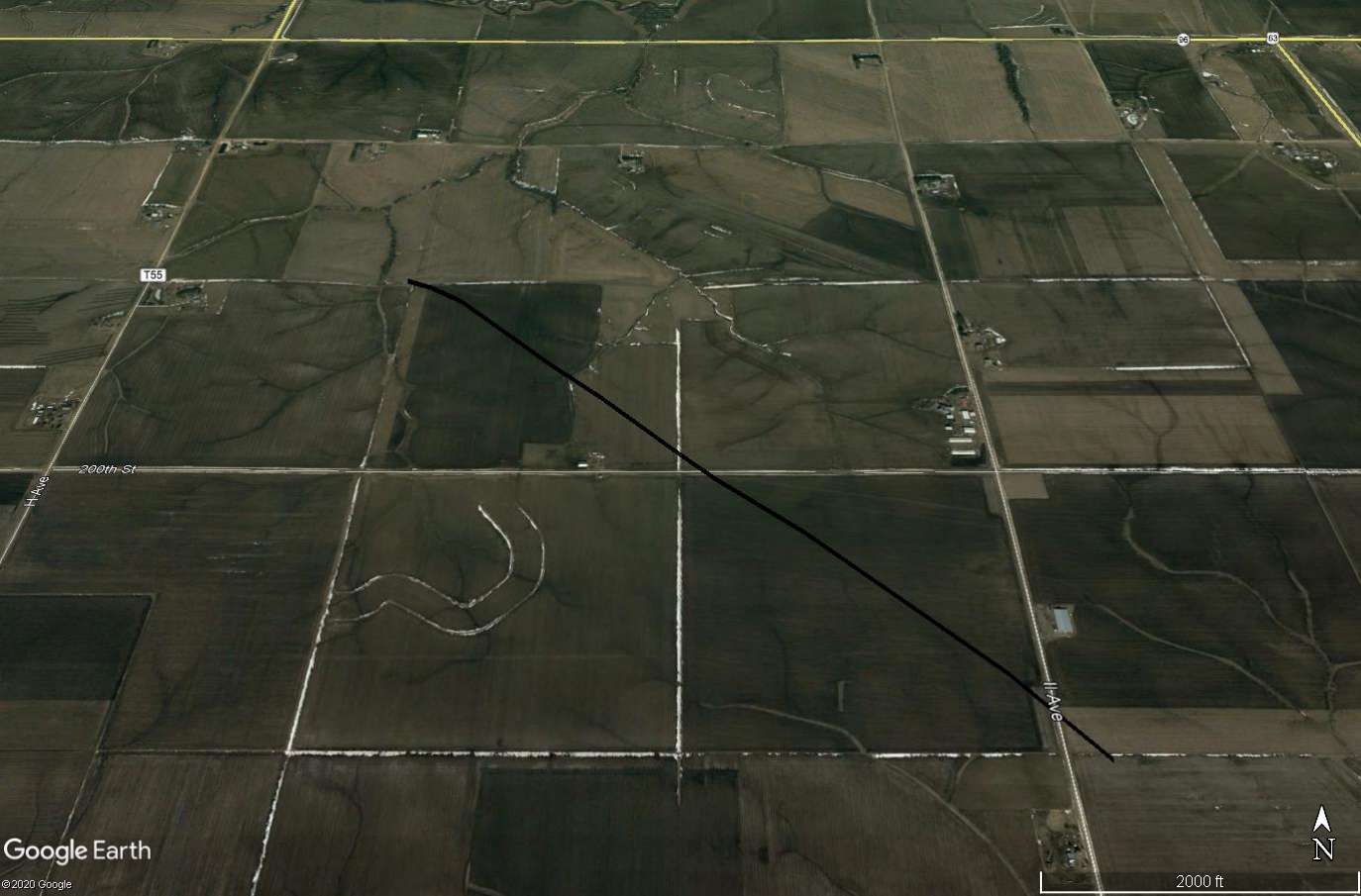
Tornadoes
|
Tornado #1 - SW of La Moille
|
||||||||||||||||
|
Tornado #2 - NE of Minerva
|
||||||||||||||||
|
Tornado #3 - Northwest of Marshalltown
|
||||||||||||||||
|
Tornado #4 - SE of Gladbrook
|
||||||||||||||||
The Enhanced Fujita (EF) Scale classifies tornadoes into the following categories:
| EF0 Weak 65-85 mph |
EF1 Moderate 86-110 mph |
EF2 Significant 111-135 mph |
EF3 Severe 136-165 mph |
EF4 Extreme 166-200 mph |
EF5 Catastrophic 200+ mph |
 |
|||||
Environment
SPC Event Review Webpage for August 10, 2020
 |
 |
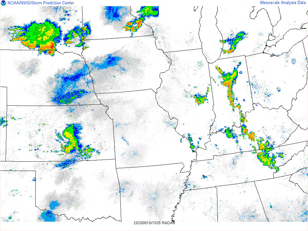 |
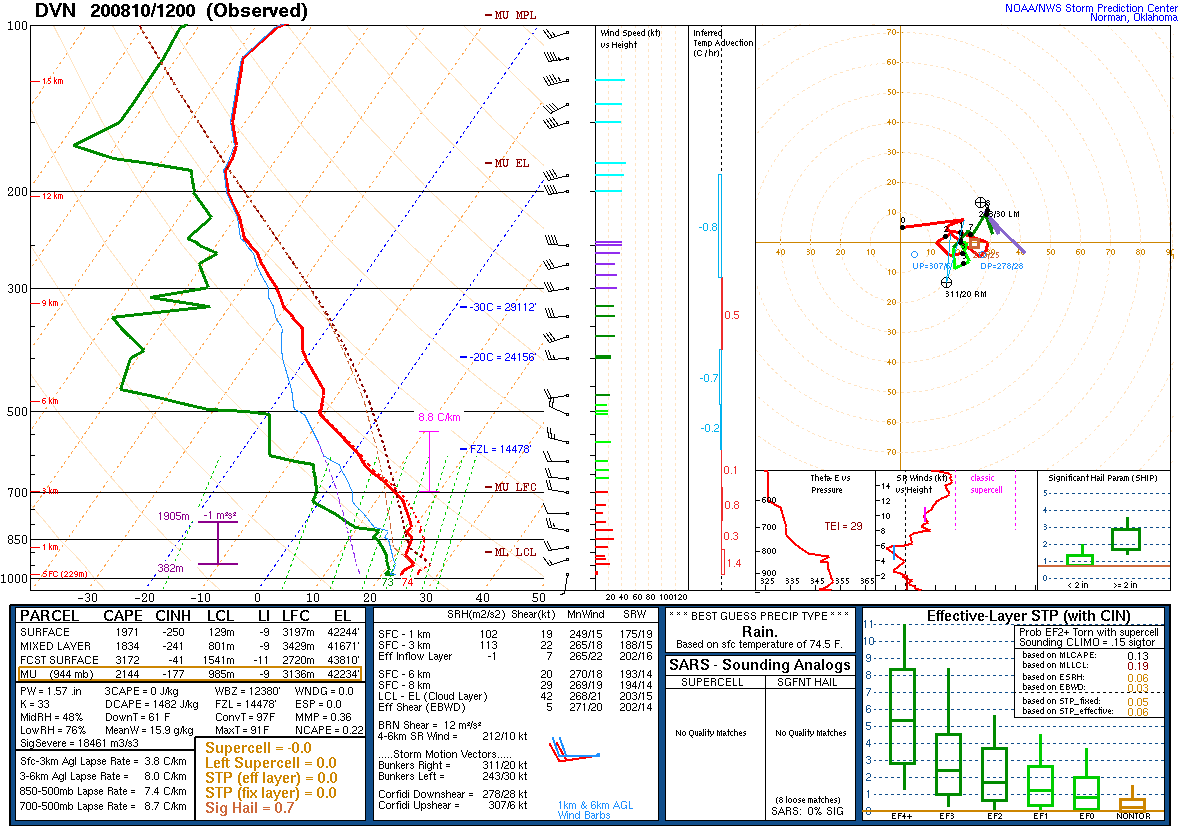
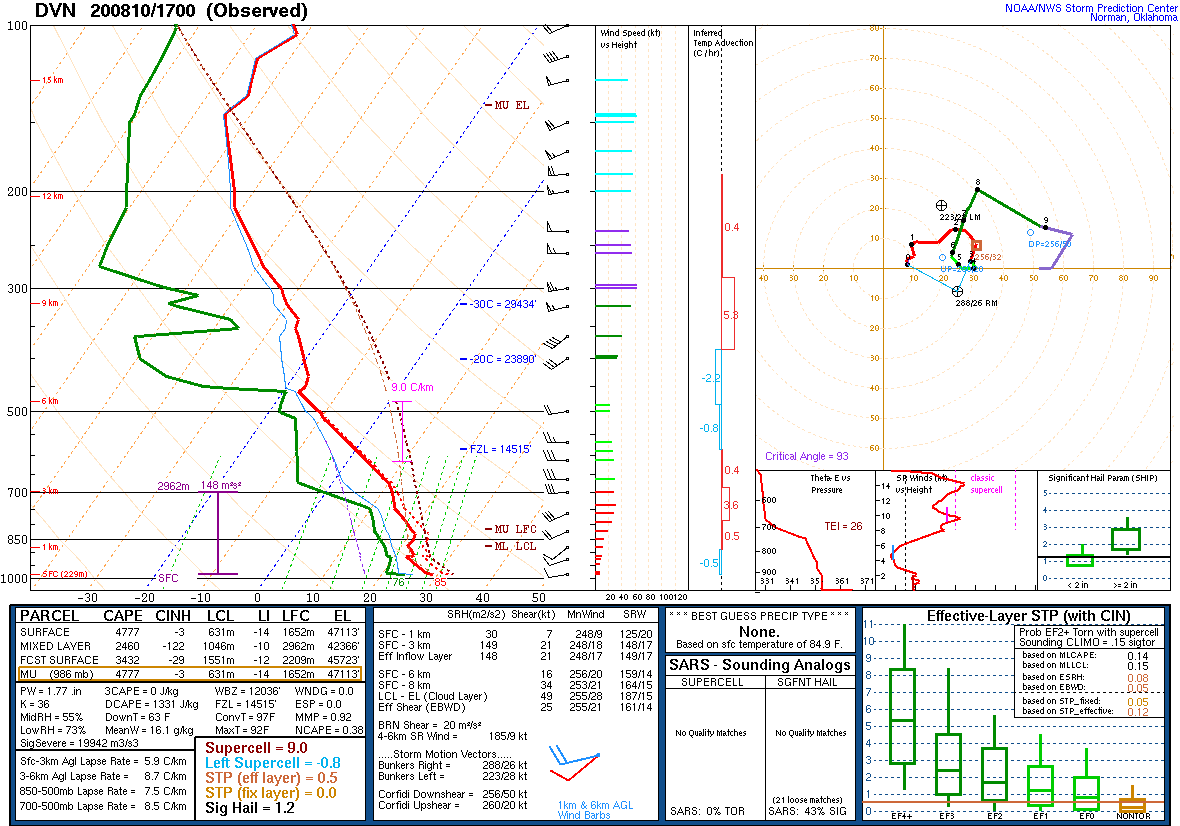
| NWS Quad Cities' Observed Sounding at 1200 UTC (7 a.m. CT) the morning of the derecho. | Special sounding launched at 1700 UTC (Noon CT) ahead of the derecho in eastern Iowa. | Regional radar loop |
 |
 |
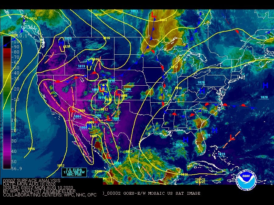 |
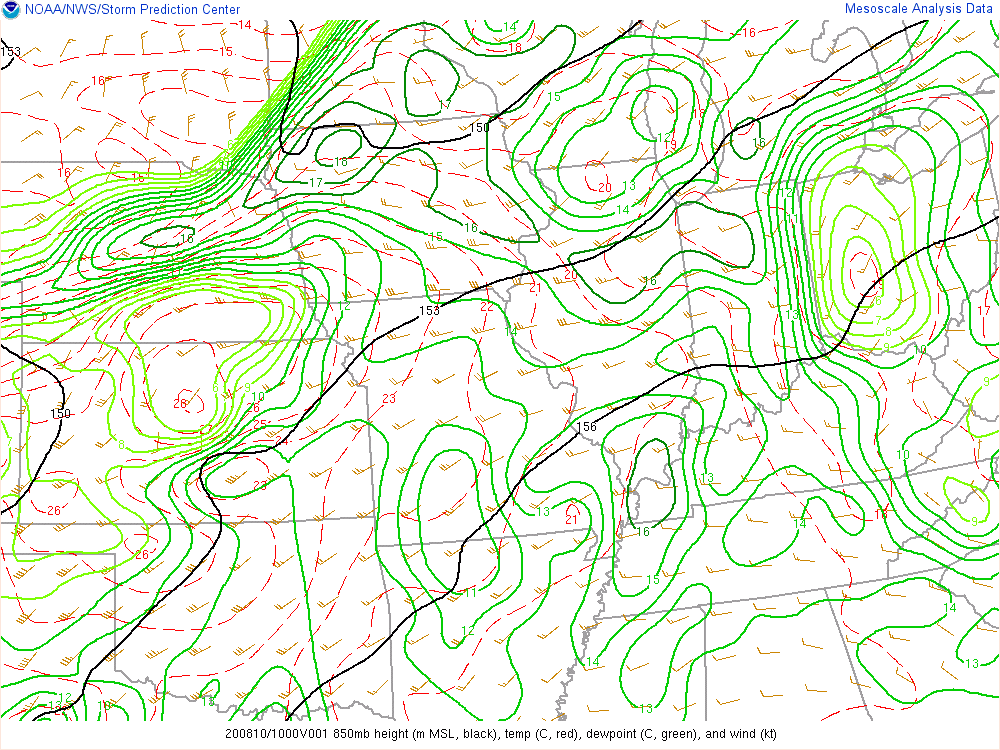
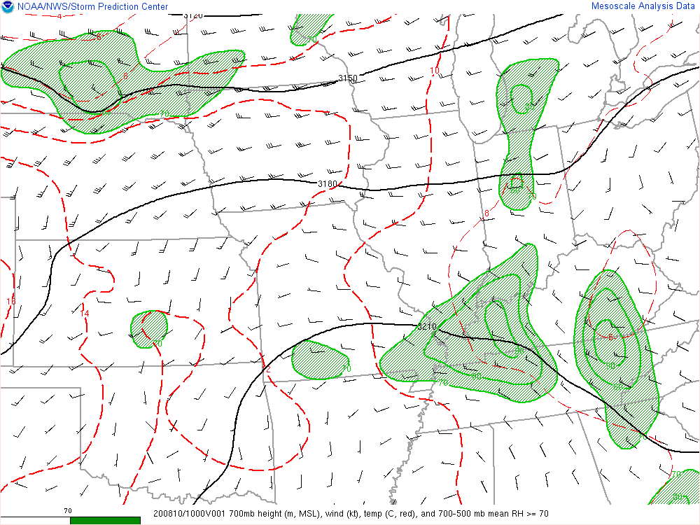
| 850mb height (m, black), temp (C, red), dewpoint (C, green), and wind (knots) | 700mb height (m), wind (knots), temp (C, red), and 700-500mb mean RH>=70. | Surface analysis and satellite animation showing the progression of the derecho through the region. |
 |
 |
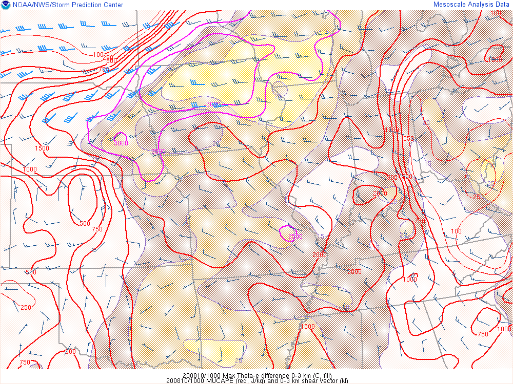 |
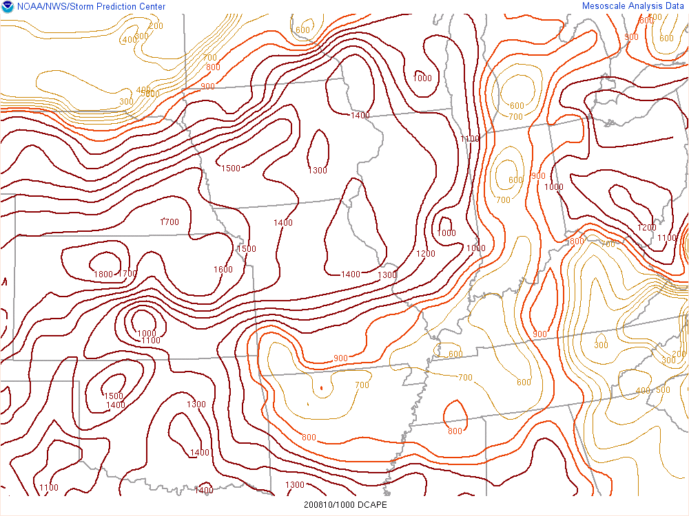
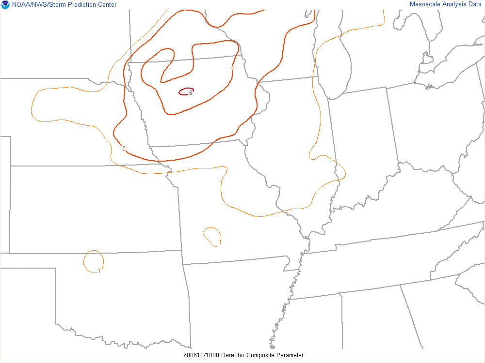
| Downdraft convective available potential energy (DCAPE) can provide an estimate of potential downdrafts of rain cooled air to the surface. Larger DCAPE values are typically associated with stronger downdrafts and possibly stronger wind gusts. | Derecho composite parameter attempts to identify areas that may become cold pool dominant for wind events. | Most unstable convective available potential energy (MUCAPE) showed extreme instability of 6000 J/kg and theta-e difference of 30C or greater. Theta-e differences greater than 30C are shown and even 35C later in the event indicate potential strength of the cold pool. |
 |
 |
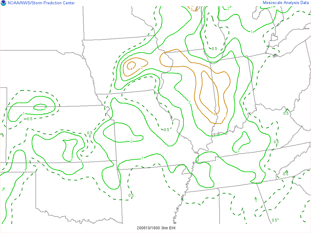 |
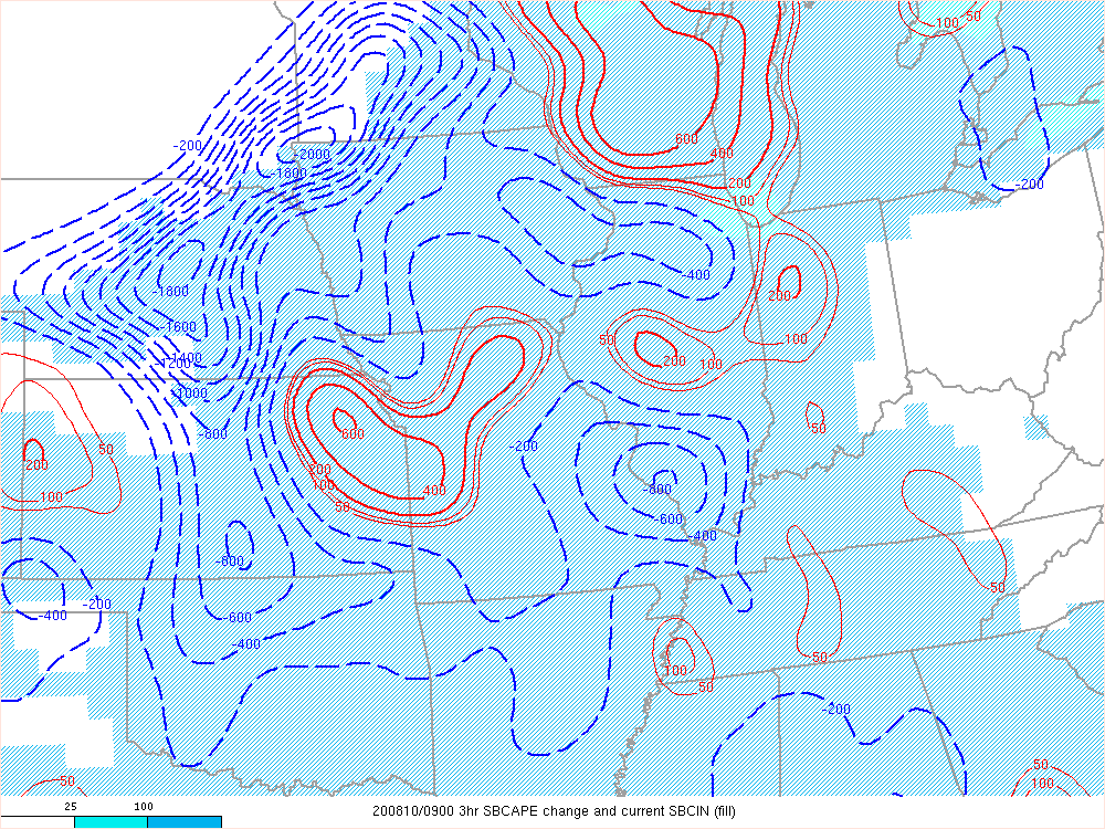
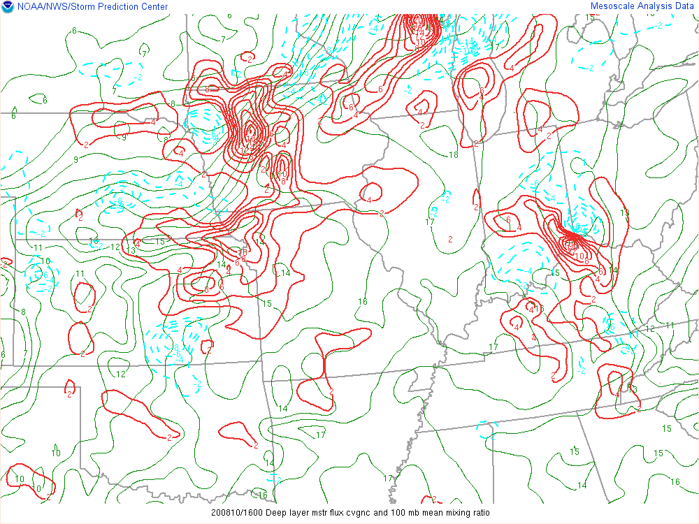
| 3-hour Surface Based CAPE change clearly shows the amount of energy the derecho used as it moved eastward across Iowa into Illinois. | Deep layer moisture convergence at 16 UTC (11 a.m CT). | Energy-Helicity Index (EHI) at 1600 UT (11 a.m. CT). |
Iowa's Past Derechos
A listing of past derechos that have impacted at least some portion of Iowa since mainly 1980. The name in quotes is taken from the "Noteworthy Events" from the Storm Prediction Center's "About Derechos" webpage with the exception of the 1877 and 2020 derecho. Click on the link(s) below the image for additional details from the Storm Prediction Center's summary, an event webpage, and/or a journal article.
 |
|
|
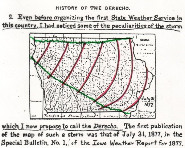
| July 31, 1877 - "The Original Derecho" Image by Hinrichs (1888) |
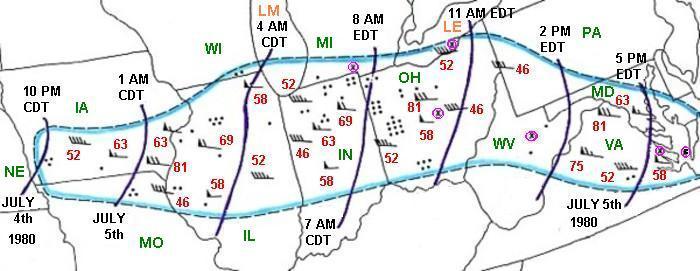
July 4-5, 1980 Derecho - "The 'More Trees Down' Derecho" Image courtesy of Storm Prediction Center |
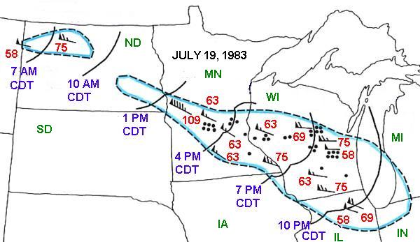
July 19, 1983 Derecho - "The I-94 Derecho" Image courtesy of Storm Prediction Center |
|
|
|
 |
| July 28-29, 1986 Derecho - "The Supercell Transition Derecho" Image courtesy of Storm Prediction Center |
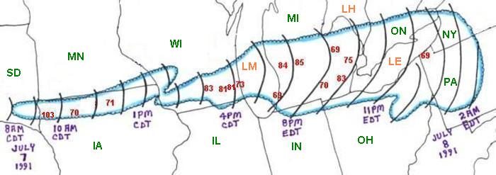
July 7-8, 1991 Derecho - "The Southern Great Lakes Derecho of 1991" Image courtesy of Storm Prediction Center |
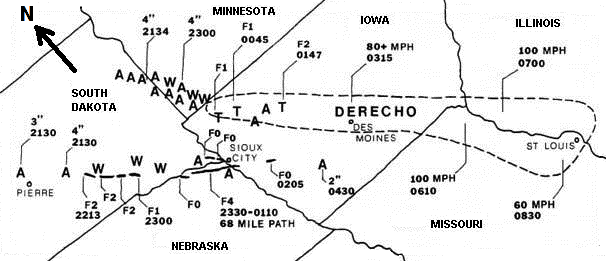
July 8-9, 1993 Derecho - "The Great Plains Derecho" Image by Bentley and Cooper (1997) |
|
|
 |
 |
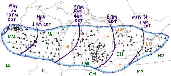
| May 30-31, 1998 Derecho - "The Southern Great Lakes Derecho of 1998" Image courtesy of Storm Prediction Center |
June 29, 1998 - "The Corn Belt Derecho" Image courtesy of Storm Prediction Center June 29, 1998 Central Iowa Tornado/Derecho Event - WFO Des Moines Summary |
July 20, 2008 WFO Quad Cities Summary |
|
|
 |
 |
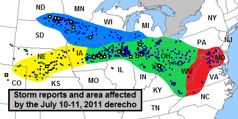
| July 11, 2011 - "The Cross Country Derecho of July 2011" Image courtesy of Storm Prediction Center July 11, 2011 East Central Iowa Derecho - WFO Des Moines Event Summary Webpage |
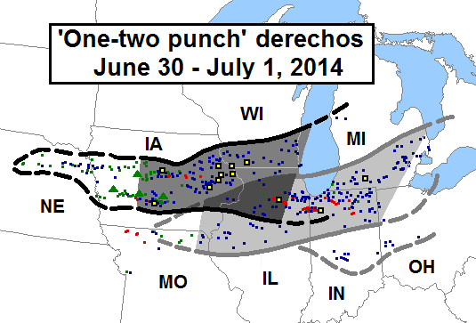
June 30, 2014 - "The One-Two Punch Derechos" Image courtesy of Storm Prediction Center June 30, 2014 Severe Weather Outbreak - WFO Des Moines Event Summary Webpage |
August 10, 2020 - "The August 2020 Midwest Derecho" August 10, 2020 Derecho - WFO Des Moines Event Summary Webpage |
Derechos Facts & FAQs
|
Derecho Facts
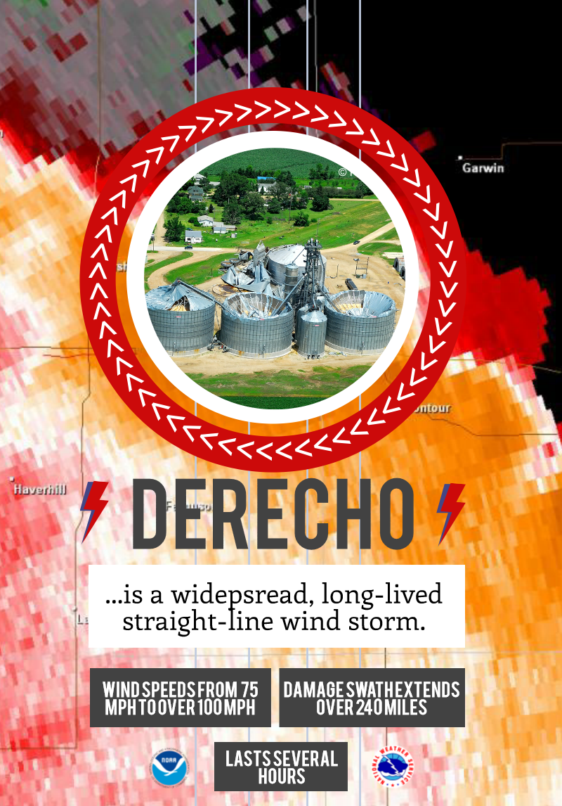
Derecho FAQs The August 10, 2020 derecho has been both equally impressive and devastating in its effect across Iowa and surrounding states. The event has often been compared to an inland hurricane or hurricanes in general. While this does help people relate to the type of wind damage seen in this event, this is where the comparisons between derechos and hurricanes end.
Finally, while the damage from a derecho can look like tornado damage, a key distinction between a derecho and a tornado is the widespread damage swath. A tornado's width is generally less than a mile with the widest tornado width around 2.5 miles. A derecho on the other hand produces damage over a much larger width of many miles. |
|
 |
Media use of NWS Web News Stories is encouraged! Please acknowledge the NWS as the source of any news information accessed from this site. |
|


.jpg)
.jpg)


 Follow us on YouTube