
Scattered thunderstorms with severe gusts, hail and a tornado risk are possible near a cold front from the Ohio Valley to the Mid-Atlantic tonight. Tropical Storm Bertha is expected to bring tropical storm conditions to portions of the Gulf Coast from the panhandle of Florida into Louisiana through Wednesday. Read More >
A complex of thunderstorms developed over portions of Wyoming Sunday afternoon (July 20, 2008). The storms became severe while shifting east through northern Nebraska Sunday evening. The severe thunderstorms moved into northwest Iowa very early Monday morning (July 21, 2008). As the severe thunderstorms continued moving southeast they further intensified and produced widespread and destructive straight-line winds of 60 to 90 mph through east central into southeast Iowa, and northwest into central Illinois. The highest measured wind gust was 94 mph in Moline, IL. Other measured wind gusts included 84 mph in Princeton, IL and 72 mph in Mount Pleasant, IA. These extreme winds produced a large swath of wind damage 20 to 40 miles wide comprised largely of downed trees and power lines. Power was knocked out to over 130,000 residents in the Quad Cities. This type of long lived and destructive wind storm is referred to as a derecho. Click here to learn more about derechos.
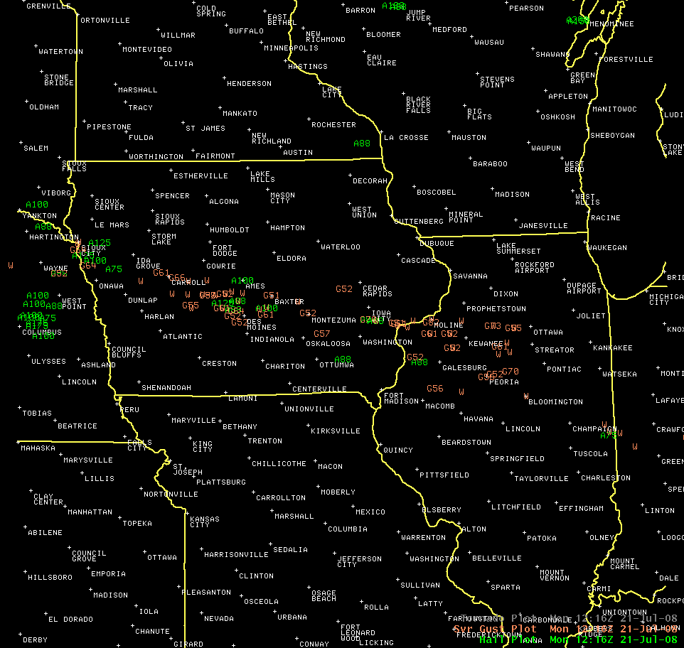
This image shows the swath of damage reports. Hail is in green (diameter in inches) and wind is in orange (gust in knots). Click images for full size picture.
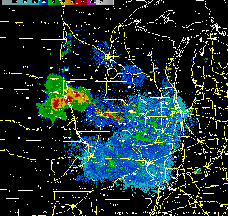
Main complex of storms moving through northwest Iowa prior to 1 am. Note the additional storms, some severe, developing out ahead through central Iowa.
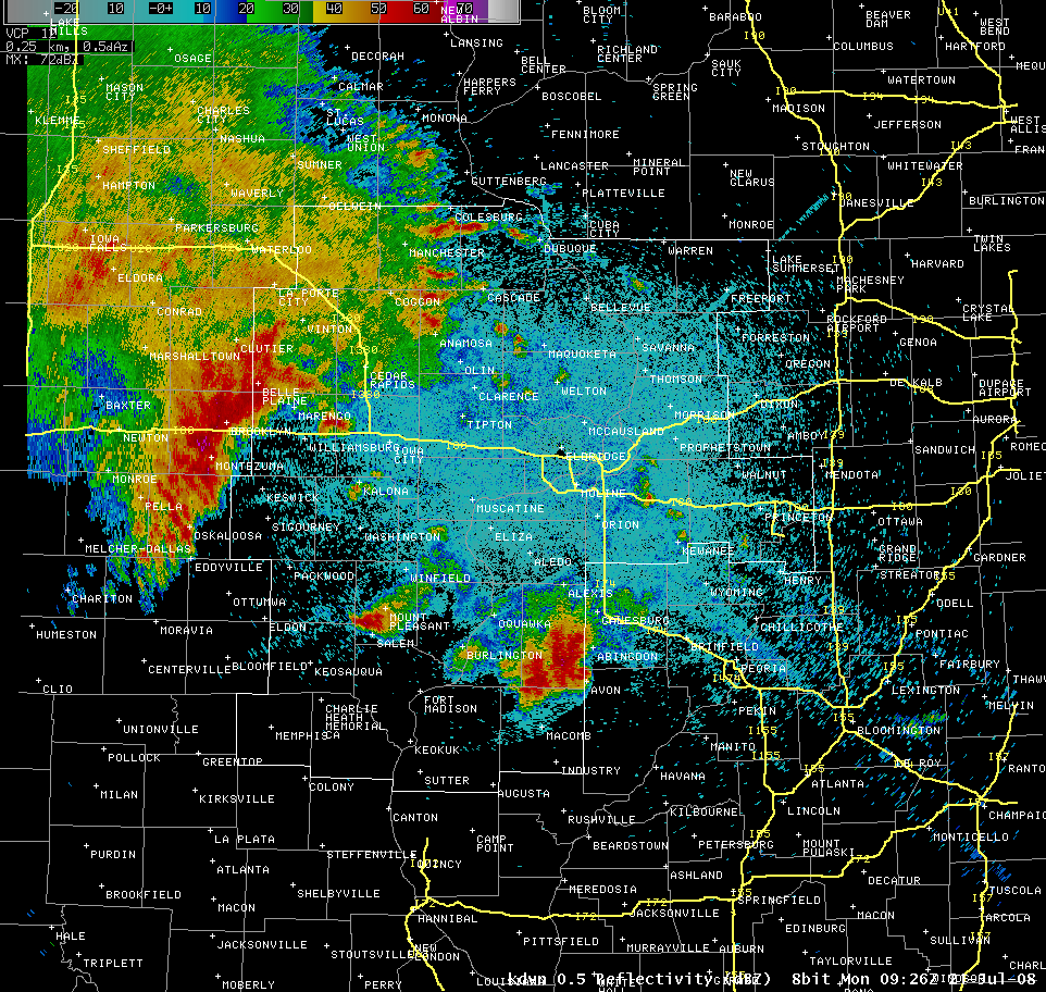
Destructive, long-lived windstorm (derecho) moving out of central Iowa into eastern Iowa. 0.5 degree base reflectivity image from KDVN at 0926z (426 A.M. CDT).
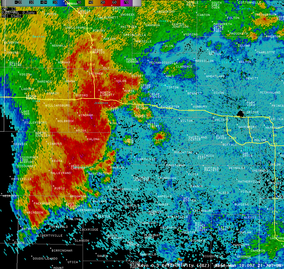
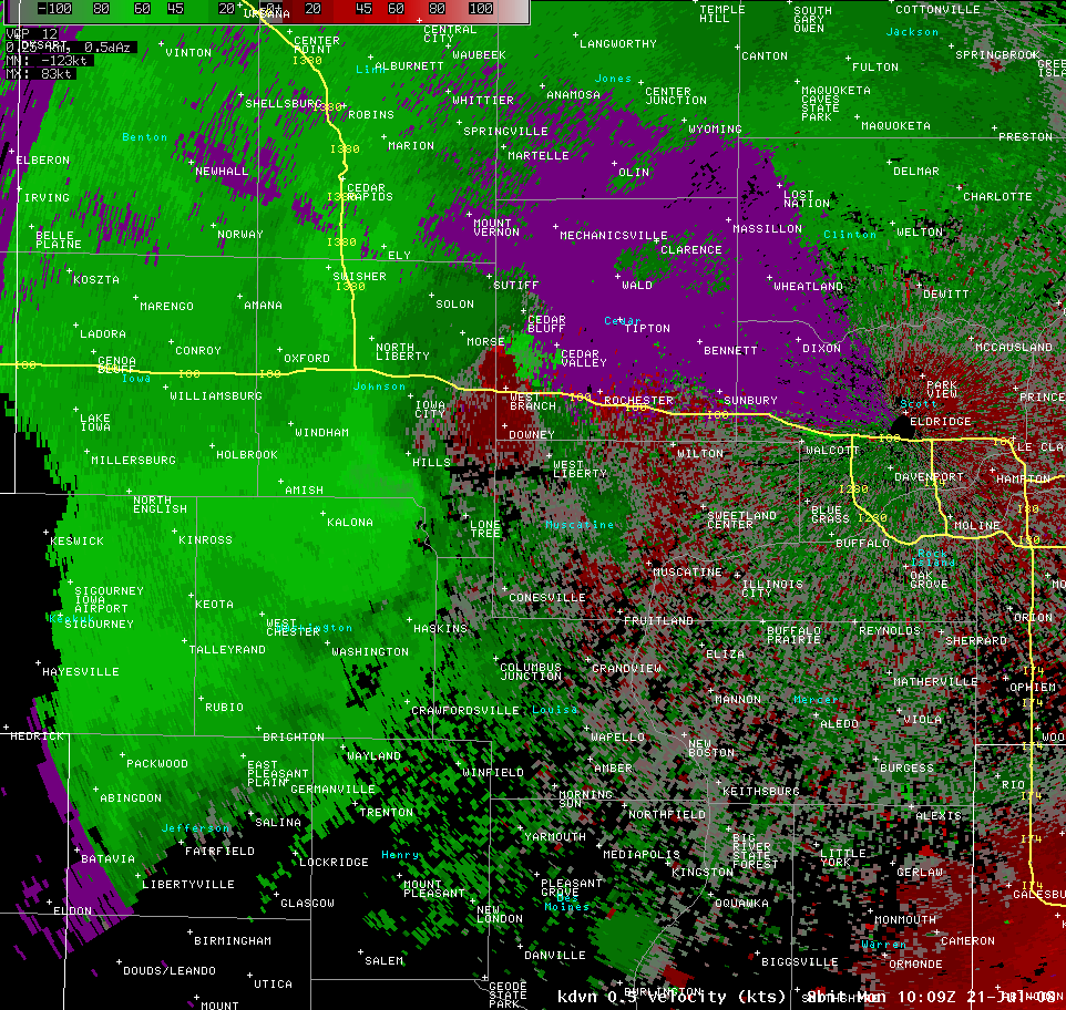
0.5 degree base reflectivity image from KDVN at 1009z (509 A.M. CDT) showing derecho moving through eastern Iowa. Notice the bowing segment from near Hills southward to Washington... marking where the strongest winds were occurring.
Corresponding 0.5 degree base velocity image from KDVN at 1009z (509 A.M. CDT). The radar was showing an area of 80 to 90 kts between Hills and Riverside at roughly 4300 ft msl (3655 ft agl). Green indicates air moving toward the radar (indicated by dark circle north of Davenport) while red indicates air moving away from the radar.
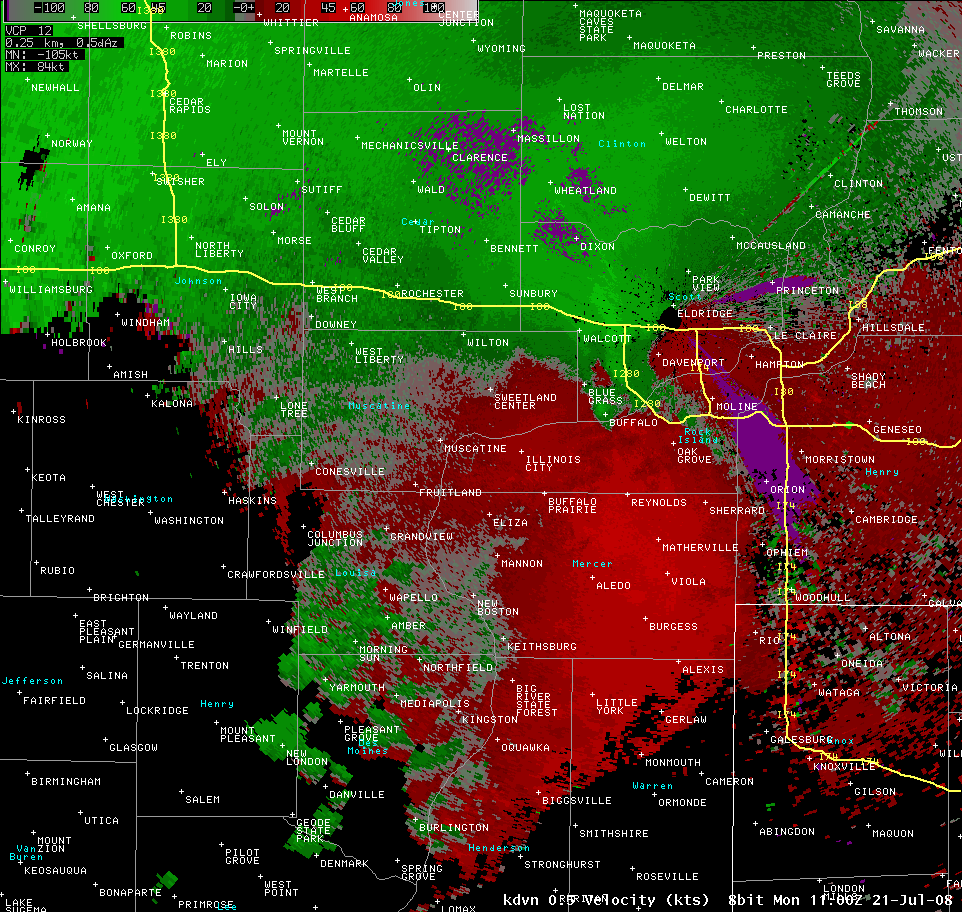
Line of destructive storms moving into the Quad Cities Metro. Note the bowing segment from southwest of Moline to Burgess denoting where the strongest winds were occurring.

0.5 degree base velocity image from KDVN at 1100z (6 A.M. CDT). Note the pronounced drop-off in velocities. This is due to sampling issues... because the wind is perpendicular to the radar beam. Because the NEXRAD Doppler radar measures only radial wind speeds (wind speeds towards and away from the radar along the radar beam) the component of the wind that is perpendicular to the radar beam cannot be measured at all.
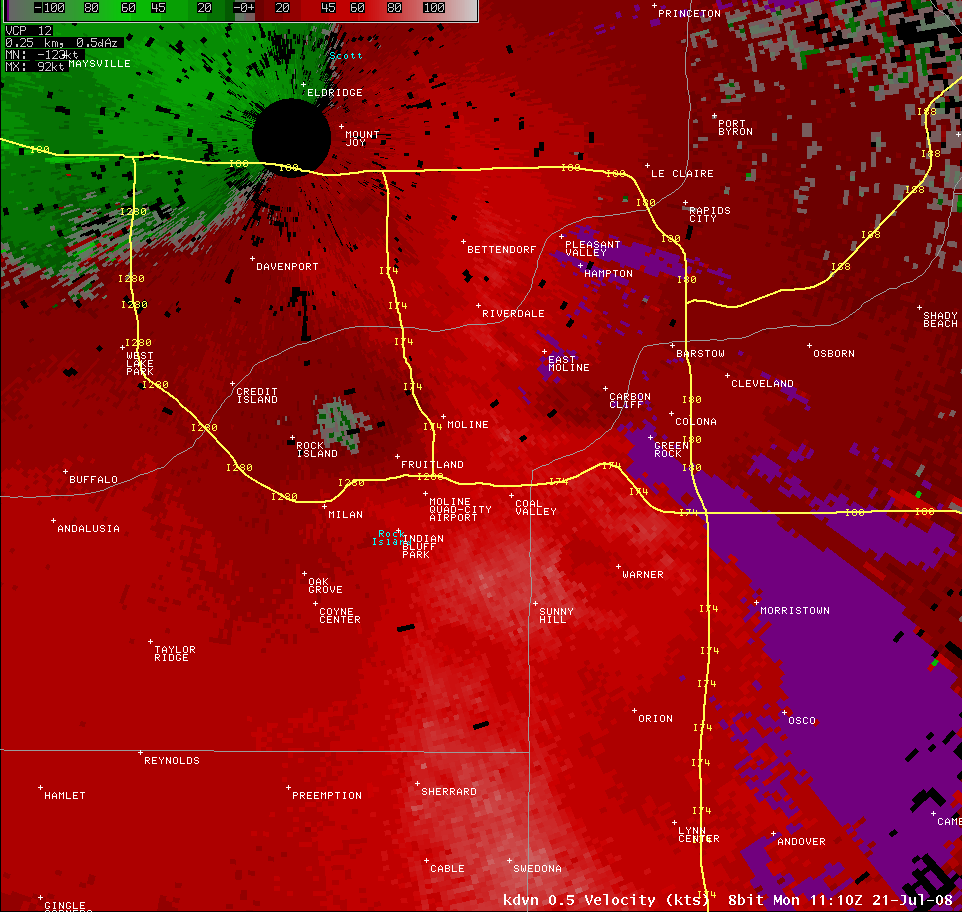
0.5 degree base velocity image from KDVN at 1110z (610 A.M. CDT) near the time that MLI ASOS measured 81 mph... before communication was lost. Backup coastal system at the airport measured 94 mph. Radar is indicating a downburst between I-280 and I-74.
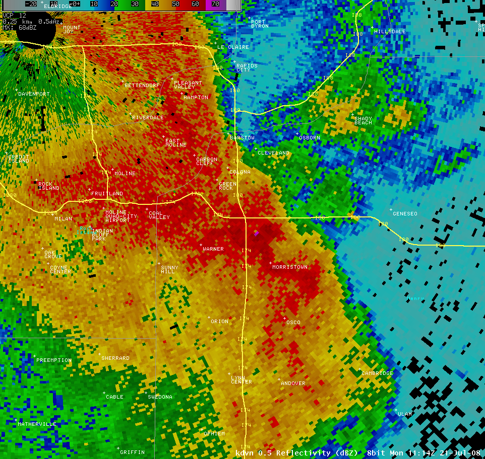
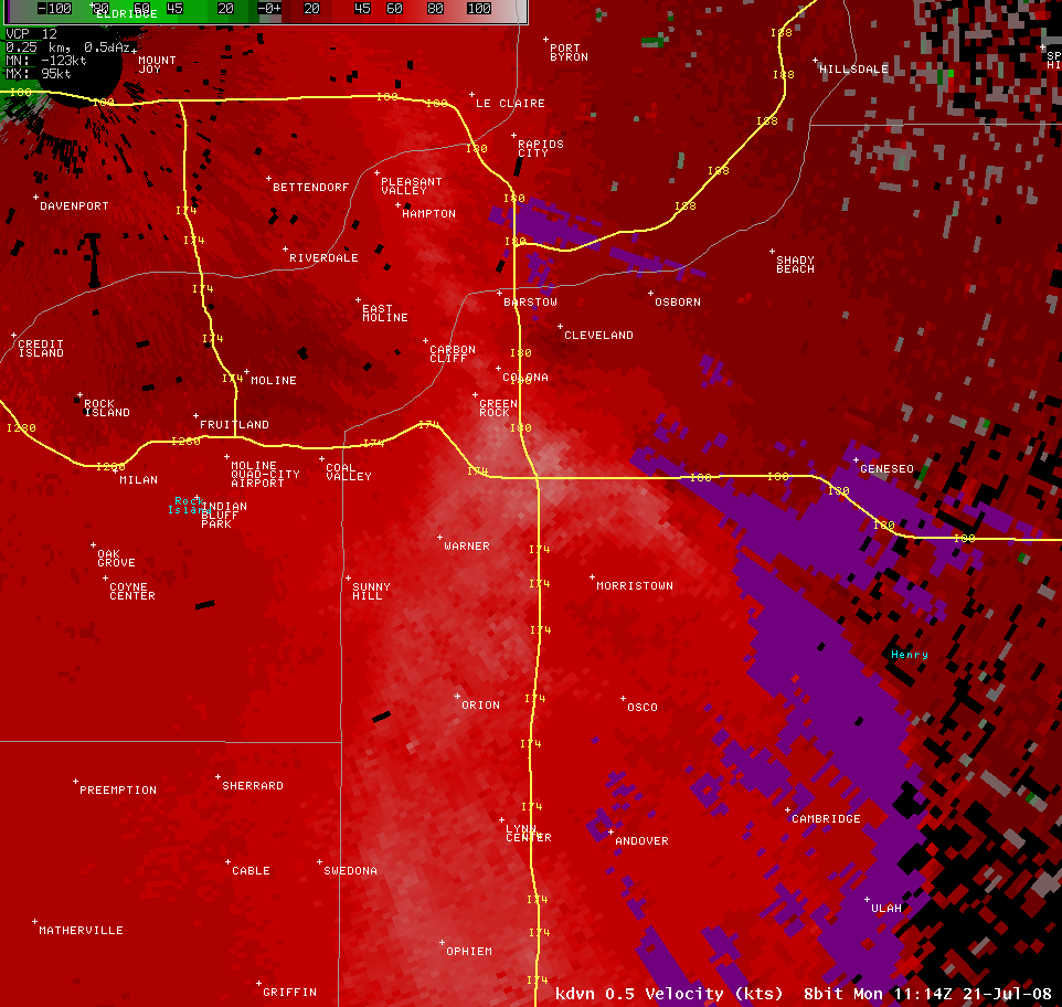
0.5 degree base reflectivity image from KDVN at 1114z (614 A.M. CDT) about the time the Indian Trails Resort was hit.
Corresponding 0.5 degree base velocity image from KDVN at about the time the Indian Trails Resort was hit. Radar is showing winds of 90 to 95 kts at roughly 1620-1700 ft msl (950-1050 ft agl) from near Colona southward to the I-80/I-74 interchange.
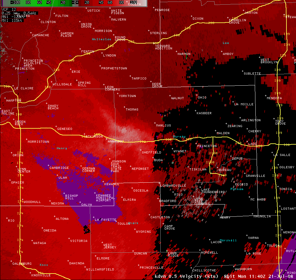
0.5 degree base velocity from KDVN at 1140z (640 A.M. CDT) still showing large area of 90-100 kts with max of 109.8 kts at 3501 ft msl (2860 ft agl north of I-80 northwest of Sheffield.
PUBLIC INFORMATION STATEMENT
NATIONAL WEATHER SERVICE QUAD CITIES IA IL
346 PM CDT MON JUL 21 2008
...STORM DAMAGE SURVEY FOR ROCK ISLAND AND NORTHWEST HENRY IL
COUNTIES...
A NATIONAL WEATHER SERVICE POST STORM DAMAGE ASSESSMENT TEAM
SURVEYED THE DAMAGE THAT OCCURRED IN ROCK ISLAND AND NORTHWEST HENRY
COUNTIES IL ON THE MORNING OF JULY 21 2008. ALL DAMAGE WAS CAUSED BY
STRAIGHT LINE WINDS.
STRAIGHT LINE WIND DAMAGE...
* LOCATION...5 MILES WEST OF THE QUAD CITY AIRPORT ON INTERSTATE
280 TO THE QUAD CITY AIRPORT...THEN ALONG THE JOHN DEERE RD/ROUTE
5 CORRIDOR FROM 1 MILE WEST OF THE I-74 BRIDGE EASTWARD GENERALLY
10 MILES THROUGH COLONA AND GREEN RIVER.
* TIME OF OCCURRENCE...BETWEEN 550 AM TO 630 AM CDT ON MONDAY JULY
21 2008.
* INJURIES/FATALITIES...ONE FATALITY AND FIVE INJURIES.
A TREE FELL ONTO A TENT AT THE INDIAN TRAILS RESORT KILLING A 4
YEAR OLD BOY...CRITICALLY INJURING A 9 MONTH OLD GIRL AND A 9
YEAR OLD GIRL. THREE OTHER CHILDREN RECEIVED MINOR INJURIES. TIME
ESTIMATED AROUND 615 AM.
* ESTIMATED WIND SPEEDS...EF1 90 TO 100 MPH.
* DAMAGE INFORMATION...
JOHN DEERE CORRIDOR FROM 1 MILE WEST OF I74 BRIDGE TO 4 MILES
EAST...SEVERAL LARGE UTILITY POWER POLES BENT OVER WITH AT LEAST
ONE NOTED SNAPPED IN HALF WITH TRAILING POWER LINES DOWN ON
JOHN DEERE RD. NUMEROUS ELEVATED BUSINESS SIGNS BLOWN OUT OR
SEVERELY DAMAGED. SEVERE DAMAGE TO A BANKS AUTOMATIC TELLER
MACHINES AND DRIVE UP OVERHANG STRUCTURE. WINDOWS BLOWN OUT OF A
FEW BUSINESSES. EMPTY UTILITY TRAILERS ON DISPLAY BLOWN ACROSS
THE ROAD AND ON THEIR SIDES. WIDESPREAD TREE DAMAGE WITH SEVERAL
LARGE TREES SNAPPED OFF AT TRUNKS OR UP-ROOTED AND DOWNED IN THE
SAME DIRECTION. MANY OF THESE DOWN ON STRUCTURES SUCH AS
HOUSES...SMALL BUSINESSES...VEHICLES AND SOME POWER LINES. LARGE
BRANCHES ESTIMATED FROM 5 INCHES UP TO 24 INCHES IN DIAMETER TOO
NUMEROUS TO COUNT SNAPPED OFF AND DOWNED.
COLONA...NUMEROUS TREES AND LARGE BRANCHES DOWN IN CENTRAL AND
SOUTHERN PORTIONS OF THE CITY. SEVERAL TREES BLOWN DOWN ON
HOUSES. BUSINESS SIGNS BLOWN OUT OR SEVERELY DAMAGED. LARGE TREE
DOWN ON POWER LINES ON ROUTE 84 JUST SOUTH OF TOWN. SIDING AND
ROOF DAMAGE TO A FEW HOUSES SOUTH OF TOWN EXPOSED ON HILLTOP.
GREEN RIVER TOWNSHIP INCLUDING INDIAN TRAILS RESORT...SEVERAL
TREES SNAPPED OFF AT TRUNK OR UP-ROOTED...ALONG WITH NUMEROUS
LARGE BRANCHES DOWN THROUGH OUT THE INDIAN TRAILS RESORT
CAMPGROUNDS. 1 LARGE TREE DOWN ON A RECREATIONAL VEHICLE IN
THE CAMPGROUND WITH SEVERE DAMAGE TO THE VEHICLE. NUMEROUS
TREES...BRANCHES AND A POWER LINE DOWN IN GREEN RIVER SUB
DIVISION.
* A 94 MPH WIND GUST WAS MEASURED AT 615 AM AT THE MOLINE/QUAD-CITY
AIRPORT BY AN AUTOMATED SURFACE OBSERVING SYSTEM.
ENHANCED FUJITA /EF/ SCALE INFORMATION...
PLEASE NOTE THE NUMBERS BELOW ARE APPROXIMATE WIND SPEEDS FOR DAMAGE
CATEGORIES.
EF0... 65 - 85 MPH
EF1... 86 - 110 MPH
EF2... 111 - 135 MPH
EF3... 136 - 165 MPH
EF4... 166 - 200 MPH
EF5... 201 MPH OR GREATER
$$
HLADIK/DUBBERKE/MCCLURE

