Heavy rainfall and flooding concerns remain for today across Central Texas and the Hill Country, with scattered thunderstorms expected this afternoon and evening. Tropical Storm Chantal has formed and will bring heavy rainfall and flooding concerns to portions of the coastal Carolinas. Life-threatening surf and rip currents are expected from the Southeast to Mid-Atlantic. Read More >
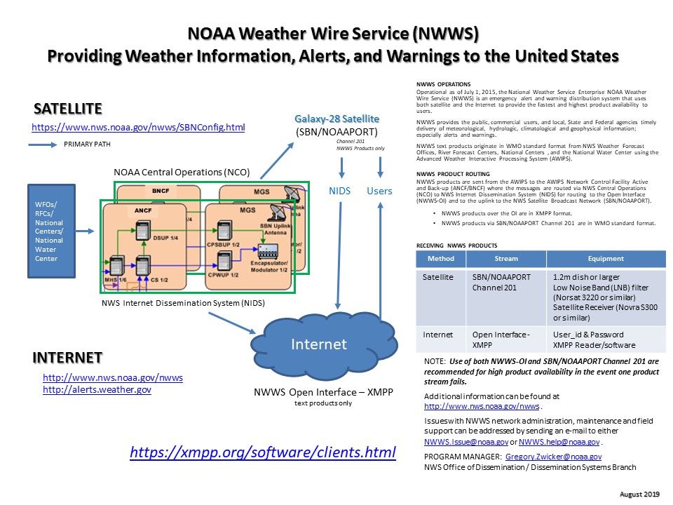
National Weather Service Dissemination
National Program
|
|
|
|
|
| Close | |
|
|
|
|
|
|
|

 
FAQs
NWWS FAQ1. Why should I use the NOAA Weather Wire Service (NWWS)?
|
||||||||||||||||||||||||||||||||||||||||||||||||||||||||||||||||||||||||||||||||||||||||||||||||||||||||||||||||||||||||||||||||||||||||||||||||||||||||||||||||||||||||||||||||||||||||||||||||||||||||||||||||||||||||||||||||||||||||||||||||||||||||||||||||||||||||||||||||||||||||||||||||||||||||||||||||||||||||||||||||||||||||||||||||||||||||||||||||||||||||||||||||||||||||||||||||||||||||||||||||||||||||||||||||||||||||||||||||||||||||||||||||||||||||||||||||||||||||||||||||||||||||||||||||||||||||||||||||||||||||||||||||||||||||||||||||||||||||||||||||||||||||||||||||||||||||||||||||||||||||||||||||||||||||||||||||||||||||||||||||||||||||||||||||||||||||||||||||||||||||||||||||||||||||||||||||||||||||||||||||||||||||||||||||||||||||||||||||||||||||||||||||||||||||||||||||||||||||||||||||||||||||||||||||||||||||||||||||||||||||||
| XOAK57 KWBC | XOAK58 KWBC | XOAK59 KWBC | XOCA52 KWBC | XOGM50 KWBC |
| XOHW KWBC | XOUS51 KWBC | XOUS52 KWBC | XOUS53 KWBC | XOUS54 KWBC |
| XOUS55 KWBC | XOUS56 KWBC | XOXX55 KWBC | XOZS50 KWBC |
Additional development is in process to place CAP v1.2 on https://alerts.weather.gov.
Implementation Date - TBD
More information on CAP v1.2 can be found at
http://docs.oasis-open.org/emergency/cap/v1.2/CAP-v1.2-os.html.
Response:
Verify configuration set-up (https://www.weather.gov/nwws)
Ensure security and firewalls are set to allow NWS URL access.
NWWS products are also available over the Internet via NWS FTP anonymous, via NOAA Weather Radio All Hazards (NWR), telephone, pager, and via commercial provider(s).
Response:
PROBLEM #1: If you did not completely exit the XMPP program before shutting down, a “phantom” account may continue to exist. This “phantom” account will prevent you logging into the NWWS-OI. An account reset will not work.
Response:
The cache or storage directory is full and will have to be cleared, purged or re-located to allow sufficient space for new products.
If you login using an “alias,” it may be interfering with the account identification. Remove the “alias” nickname and check to see if the problem is resolved. If the problem persists, contact the NWWS Program Office.
Response:
Sometimes immediately following a transition, a virtual chatroom “bubble” containing a small number of users (having also automatically connected) is created. Products appear to come in timely and no issues have been raised whenever this situation has occurred. NWS is looking into the cause and potential risks. Currently, NWS cannot verify product dissemination (assumption is product distribution is equal). Resetting or restarting the software or system will re-align the user’s account to the main NWWS-OI chatroom.
Response:
Verify that your software is filtering correctly and the product name is correct. If so, check with the WFO to verify the product was sent to NWWS. WFOs may not send all products to NWWS. Some products require a manual selection by the originator for the product to be disseminated over NWWS. If the WFO has sent the product for NWWS dissemination, please e-mail the NWWS Program Office to see if the product was correctly received. Some products though properly received may not be configured for dissemination over the NWWS Open Interface or NWWS PID 201 or may have experienced a bit error.
Note: Products cannot be resent over NWWS (with the only exception being an emergency NWWS system reset and the cache was not cleared).
Response:
NWS originally developed an EUC for Windows 7 and Windows 8. An updated EUC for Windows 10/11 is available via the NWS Virtual Lab website. https://vlab.noaa.gov/group/guest/welcome.
Email request to become an “External Partner.” Sign-in as “External Partner” and search on "NWWS EUC".
Note: There is a commercial XMPP client version available if the EUC does not work with your system configuration or you cannot develop an XMPP software application. Search “migrate to weather wire.”
Response:
A list of NWR receivers can be found here: NWR Receivers
Response:
Nearby NWR stations can be found using the station search web page here: NWR Station Search
Response:
A list of weather stations by state can be found here: NWR station list by state
Response:
NWR station outages can be reported here: NWR station outage reporting
Response:
Information about automated voicing can be found here: NWR automated voicing
Response:
Information about Spanish voicing can be found here: NWR Spanish voice
Response:
Information about the NWS alarm policy and when tests are conducted can be found here: NWS warning and tests
Response:
Information about the Specific Area Message Encoding (SAME)can be found here: Specific Area Message Encoding (SAME)
Response:
Information radio reception can be found here: NWR reception
Response:
Information weather radio at sea can be found here: NWR marine
Response:
Information about NWR All Hazards can be found here: NWR All Hazards
If you want to report an outage or other transmitter problem, click here.
Response:
(a) Overview. The National Weather Service (NWS) Emergency Managers Weather Information Network (EMWIN) is a dissemination service operating 24-by-7 to provide timely alerts, watches, warnings, forecasts and observations from NWS Weather Forecast Offices (WFOs), River Forecast Centers (RFCs), NWS National Centers (e.g., National Hurricane Center), and other US Federal and International partners. It is intended to be used by US local, state and federal level emergency management organizations; WMO Regional Association IV (RA-IV) member states and geographically included countries in support of emergency management related activities; the media; educational institutions; and the public at large.
(b) Purpose. EMWIN supports the NWS mission to prevent the loss of life and property, and enhance the national economy through the timely dissemination of climate, weather and water alerts, watches, warnings, forecasts and observations. EMWIN also supports the NWS execution of its responsibilities as the WMO RA-IV Regional Telecommunications Hub (RTH) and Global Information System Centre (GISC), to extend the Global Telecommunications Services (GTS) to RA-IV member states and the other geographically included countries.
(c) Broadcast Service Implementation. The EMWIN broadcast service uses two methods to make products available:
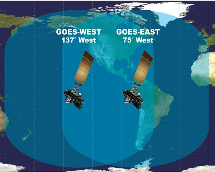
(c.1) Satellite Broadcast. The NESDIS HRIT/EMWIN broadcast from the GOES-East and West satellites is available for reception by anyone located within the respective satellite's broadcast footprint operating the appropriate receiving equipment. Additional information on the HRIT/EMWIN receiver and associated equipment is available from NESDIS -
(c.2) File Server. The EMWIN FTP file server makes aggregated product files in .zip format available for anonymous download over the public Internet - it does not require a user account:
Response:
(a) Satellite Broadcast. A High Rate Information Transmission (HRIT) compliant receiver and associated ground terminal equipment is needed to receive the EMWIN product streams on the NESDIS HRIT/EMWIN broadcast from the GOES-East and West satellites. Additional technical information on the HRIT/EMWIN receiver and associated equipment is available from NESDIS: https://noaasis.noaa.gov/GOES/HRIT/about_hrit.html
The HRIT/EMWIN broadcast contains multiple virtual channels with unique content - the EMWIN portion of the broadcast is found on the following three Virtual Channel IDs (VCID):
| VCID | Description | Content |
|---|---|---|
| 20 | EMWIN Priority | EMWIN Priority 1 & 2 Text Products* |
| 21 | EMWIN Graphics | Image Products |
| 22 | EMWIN Other | EMWIN Priority 3 & 4 Text Products* |
(b) File Server. A computer with Internet access is needed to download files from the EMWIN FTP file server: https://tgftp.nws.noaa.gov/SL.us008001/CU.EMWIN/DF.xt/DC.gsatR/OPS/
Downloading files can be accomplished using a web browser Graphical User Interface (GUI) or an FTP command line interface. Commercial applications or scripts which automate either of these methods may be used as well. The latest text and image products are aggregated in time sequenced files on the file server. Additional details are available in the eEMWIN FTP Service Description v1.1
Response:
a) The EMWIN broadcast consists of US and International WMO bulletins in text file format; and images or picture files in JPG, GIF and PNG file formats.
(b) Text bulletin and image files larger than 5.0 Kbytes in size are compressed into .zip file format prior to broadcast and must be unzipped to return them to their native file format (.txt, .png, etc.)
(c) Text Bulletins - The identity of text bulletins referenced by their WMO header information (notes 1,2) may be found in the EMWIN_Text_Product_Catalog_210525-1448
(d) Image Files - a listing of each unique image file with its title, WMO header, and representative picture may be found in the EMWIN Image Product Catalog.
Notes:
Response:
The valid Tsunami bulletins listed in the governing NWS Directive xxx NWSI 10-701, Tsunami Warning Center Operations, and on the published Tsunami Web page ( https://tsunami.gov/?page=product_list ) are included on the EMWIN broadcast. The list of individual products is presented in "Appendix D – Weather Program Listing" in the EMWIN_Text_Product_Catalog_210525-1448.
Response:
EMWIN does contain the bulletins listed in the Regional Association IV – Hurricane Operational Plan for North America, Central America and the Caribbean. The list of individual products is presented in "Appendix D – Weather Program Listing" in the EMWIN_Text_Product_Catalog_210525-1448. After the annual RA-IV Hurricane Committee meeting, the published Op Plan revision is reviewed, and the products on the EMWIN broadcast are updated to address any changes.
Response:
EMWIN contains international text products and image files which are not available on the NOAA Weather Wire Service (NWWS).
EMWIN contains a smaller number of US NWS products when compared to NWWS, but also includes some US NWS products not found on NWWS.
A Comparison ...
AWIPS IDs (ref: AWIPS Category Code ) of US text products from NWS Offices and National Centers included on the EMWIN broadcast (effective Aug 11, 2021) are presented below. Those AWIPS IDs presented in red text identify products which are also available on NWWS. Additional AWIPS IDs found on NWWS but not on EMWIN are not listed.
| Text Products / Priorities | Higher Priority (1 and 2) | Lower Priority (3 and 4) |
|---|---|---|
|
Analysis & Climate (AB-CX)
|
DGT, MIS, SCC*, STQ*, SWO*, TWD*, TWO*, TWS* |
AQA, AQI, ASA, AWS, CF6*, |
|
Weather Alerts and Warnings (WA-WY) |
AWW, DSA*, EWW, FFW, HLS, HWO, LSR, PTS*, PWO, SAW, SEL, SEV, SLS, SPS, SQW, SVR, SVS, TCD*, TCE, TCM*, TCP*, TCU*, TCV, TIB*, TOR, TSU*, WSW, WWA, WWP* |
SWS |
|
Non-Weather Emergency Message Products (ref) |
ADR, AVA, AVW, BLU, CAE, CDW, CEM, DMO, EQW, EVI, FRW, HMW, LAE, LEW, NUW, RHW, RMT, RWT, SPW, TOE, VOW |
|
|
Forecast (FA-FZ) |
AFD, CCF, CFW, COD*, ESF, GLF*, HSF*, ICE*, NOW, PFW*, PRE*, PMD, PWS*, QPF*, RFR*, RDF, SMF, TCA* |
AFM, AFP, AWU, ESS, FWL, LFP, PFM, PRB, QPS, SAG*, SCD, SCS, SFD, SFP, SFT, TVL, ZFP |
|
Notices: Admin (NO-NT) and warning/cancel related (NW) |
ADA, ADM, FTM, PNS, REP*, STA*, TST*, TMA, WCN |
OPU |
|
Surface Observations |
OSO*, REC, RER, SSM*, STO, TPT*, |
AGO, PLS |
|
Space Weather |
ADV, ALT, DAY, SUM, WAT |
|
|
Hazard / Public Warnings |
DSW, EQI, NPW, RFW, SAB |
|
|
Fire Weather Products |
FWD*, FWN, FWO, FWS |
FWF, FWM, RFD |
|
Hydrologic Products |
ESG*, FFA, FFG, FFH, FFS, FLS, FLW, HYD, RR5*, RR7*, RVA |
FLN, HMD, HYM, HYW, RRM, RVD, RVF, RVM, RVR, RVS |
|
Marine Products |
CGR, CWF, LSH, MIM*, MWS, MWW, NSH*, OFF, OMR, SMW, SRF, TID |
|
|
Aviation Products |
ABV*, FZL, MAN*, MTR*, SGL*, TAF (note 1)
|
|
|
Other |
WOU, SAT*, SPE*, TCS* |
RBG |
Notes:
RED text = also available on the NOAA Weather Wire Service (NWWS)
* = limited by EMWIN to specific WFOs (see Appendix A, EMWIN Text Product Catalog)
highlighted = not found in the AWIPS Category Code listing.
Response:
ISCS is a satellite data distribution system operated by the United States National Weather Service (NWS), providing support to (1) the World Area Forecast System (WAFS), and (2) the Region IV Meteorological Telecommunications Network (RMTN). ISCS support for WAFS is on behalf of the International Civil Aviation organization (ICAO) and World Meteorological Organization (WMO).
ISCS/WAFS purpose is to provide the worldwide aviation community with operational meteorological forecasts and information about meteorological phenomena required for flight planning and safe, economic, and efficient air navigation. The ISCS operates on a 24-hour/365-day basis. ISCS support for RMTN is part of a cooperative effort between NWS and WMO to improve the Global Telecommunications System (GTS), in WMO Region IV (North and Central America).
Response:
The WAFS portion of ISCS is moving away from satellite broadcast of aviation related data products, and a WAFS Internet File Service (WIFS) has been established as the replacement. WIFS is currently available for access over the Internet to ISCS/WAFS users.
Response:
The ISCS satellite broadcast of both WAFS data and RMTN data will be terminated simultaneously for all users of ISCS the end of June 2012. However, alternative methods will be available to WMO RA-IV users within the next 12 months.
Response:
ISCS WAFS users can obtain WAFS related data today by accessing the WAFS Internet File Service (WIFS) over the Internet.
ISCS RA-IV RMTN users can obtain RA-IV related GTS and WAFS data by accessing the Global Telecommunications Internet File Service (GIFS) over the Internet. The GEONetcast-Americas (GNC-A) satellite broadcast is a backup for the NWS GIFS.
Response:
The primary difference between WIFS data GIFS data is that WIFS will provide only WAFS data products. GIFS will provide both WAFS and GTS data products in a fashion similar to the current ISCS broadcast.
Response:
WAFS users can register by the Internet for access to WIFS at – https://aviationweather.gov/wifs/registration/index
Response:
When GIFS is available; users should contact the ISCS Program Office for access authorization.
Response:
The NWS, ISCS Program Office is planning to migrate away from the NOAAnet (now called OPSNet) circuits provided to RA-IV users by June 2012. Users will be notified of the plan to move away from these circuits by June 2012. ISCS users in WMO RA-IV can submit their data by using the Email Data Ingest Service (EDIS) currently available at the NWS Telecommunications Gateway (NWSTG). Users that have not already established an EDIS account with the NWSTG should contact the ISCS Program Office for access authorization. Only text data will be accepted via email from the Users. Users may also FTP their data if they are subscribers to the NWSTG FTP Input (Ingest) Service. Information on the NWSTG FTP Input Service can be found on the Internet at https://www.weather.gov/tg/ftpingest.html.
Response:
All of the ISCS data (WAFS and WMO RA-IV data) is also available on the GTS and via the Internet from the NWSTG FTP File Service (https://www.weather.gov/tg/dataprod.html). In addition; the NWS is also investigating the GEONetcast-Americas (GNC-A) satellite broadcast as a backup for the NWS GIFS. Additional information on GNC-A can be found on the Internet at https://www.geonetcastamericas.noaa.gov/.
|
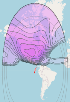
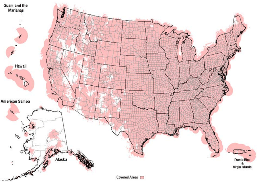
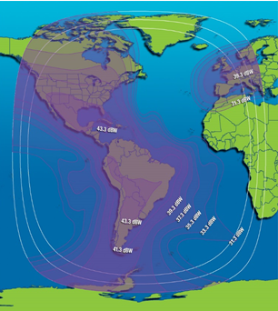
GEOGRAPHICAL COVERAGE - The images below present the radio frequency coverage plots for the NWWS, EMWIN and ISCS satellite broadcasts and the NWR VHF radio broadcasts. Any potential user will need to ensure they are in the respective footprint for signal reception. |
 |
EMWIN - Emergency Managers Weather Information Network
Source: https://noaasis.noaa.gov/GOES/HRIT/broadcast.html
NWR - NOAA Weather Radio
Source: https://www.weather.gov/media/nwr/NWR_Propagation.pdf
ISCS - International Services and Communication Systems
|
|
||||||||||
| Services Click the links below to view details on the services. | ||||
| Dissemination | NWR | NWWS | EMWIN | ISCS |
| Satellite | No | YES | YES | YES |
| Radio Broadcast | YES | No | No | No |
| Internet (Push) | No | YES | No | No |
| Internet (Pull) | No | No | YES | YES |
| No | No | No | No | |
| Direct to Social Media | No | No | No | No |
| Interactive Webpage | No | No | Yes (see note) | Yes (see note) |
| US National Products | YES | YES | YES | YES |
| International Products | No | No | YES | YES |
| Image Products | No | No | YES | YES |
| NOTES: | Web Page GUI allows products to be downloaded by clicking on the product file(s). | |||
| SYSTEM: NWR | |||||
| NOAA Weather Radio | |||||
| - Geo Coverage: | Over 1000 VHF FM transmitters across USA and territories (details) | ||||
| - Receiving System: | Commercial NWR Receiver with 7-discrete frequencies between 162.400 MHz to 162.550 MHz (details) | ||||
| - Access Constraint(s): | Open access to voice broadcast of all NWR transmitters within range (details) | ||||
| - Est. Cost (one time) | NWR commercial receivers $20 - $120 (details) | ||||
| - Est. Cost (recurring) Electric power consumption and/or batteries. | None | ||||
| Supplemental System Information | |||||
CTA-2009-B Receiver Specification |
|||||
| NWR Logo Requirements | |||||
| SAME Codes | |||||
| National Weather Service Instruction 10-1712 | |||||
| SYSTEM: NWWS | |||||||||||||||||||||||||
| NWWS - Satellite Broadcast | |||||||||||||||||||||||||
|
|||||||||||||||||||||||||
| NWWS - Internet Push (a.k.a.: NWWS Open Interface (O/I)) | |||||||||||||||||||||||||
|
|
|||||||||||||||||||||||||
| Supplemental System Information | |||||||||||||||||||||||||
|
|
|||||||||||||||||||||||||
| SYSTEM: EMWIN | |||||
| EMWIN - Satellite Broadcast | |||||
| - Geo Coverage: | 2/3's Globe (https://noaasis.noaa.gov/GOES/HRIT/broadcast.html) | ||||
| - Receiving System: | HRIT satellite receiving system and application software (https://noaasis.noaa.gov/GOES/HRIT/manu_list.html) | ||||
| - Access Constraint(s): | Open access, user account not required | ||||
| - Est. Cost (one time) | Varies: computer, software, receiver [commercial receiver: $20 - $60K; hobby receiver: $1000 - $1800] | ||||
| - Est. Cost (recurring) | Varies (local computer, software and receiver maintenance) | ||||
| EMWIN - Internet Pull (a.k.a.: EMWIN FTP server) | |||||
| - Geo Coverage: | Global via public Internet details | ||||
| - Receiving System: | Computer with Internet connection and OS / Browser software details | ||||
| - Access Constraint(s): | None - anonymous FTP server; NWS may limit/reject the access of abusive users | ||||
| - Est. Cost (one-time): | Varies (computer, software) | ||||
| - Est. Cost (recurring): | Varies (local computer/software maintenance, public internet service) | ||||
| Supplemental System Information | |||||
- About HRIT/EMWIN |
|||||
| - HRIT/EMWIN Broadcast | |||||
| - HRIT/EMWIN Broadcast Channels, Product Groups | |||||
| - HRIT/EMWIN Reception | |||||
| - EMWIN Text Product Catalog | |||||
| - EMWIN Image Product Catalog | |||||
| SYSTEM: ISCS | |||||
| ISCS - Satellite Broadcast [a.k.a.: GEONETCast- Americas (GNC-A)] | |||||
| - Geo Coverage: | WMO RA-IV Region, plus (details) | ||||
| - Receiving System: | C-band receiver with FAAST demod software/appliance (details) | ||||
| - Access Constraint(s): | Open access with use of FAAST demod - user account not required | ||||
| - Est. Cost (one time) | Varies: computer, software, receiver [commercial receiver: $20 - $30K] (details) | ||||
| - Est. Cost (recurring) | Varies (local computer, software and receiver maintenance) | ||||
| ISCS - Internet Pull [a.k.a.: GTS Internet File Service (GIFS)] | |||||
| - Geo Coverage: | Global via public Internet | ||||
| - Receiving System: | Computer with Internet connection and OS / Browser software (details) | ||||
| - Access Constraint(s): | None - anonymous FTP server; NWS may limit/reject the access of abusive users | ||||
| - Est. Cost (one-time): | Varies (computer, software) | ||||
| - Est. Cost (recurring): | Varies (local computer/software maintenance, public internet service) | ||||
| Supplemental System Information | |||||
- About GEONETCast Americas |
|||||
| - GNC-A Product List | |||||
| - GNC-A Documentation | |||||
|
Here are various modes for receiving weather information, alerts, and warnings. |
|
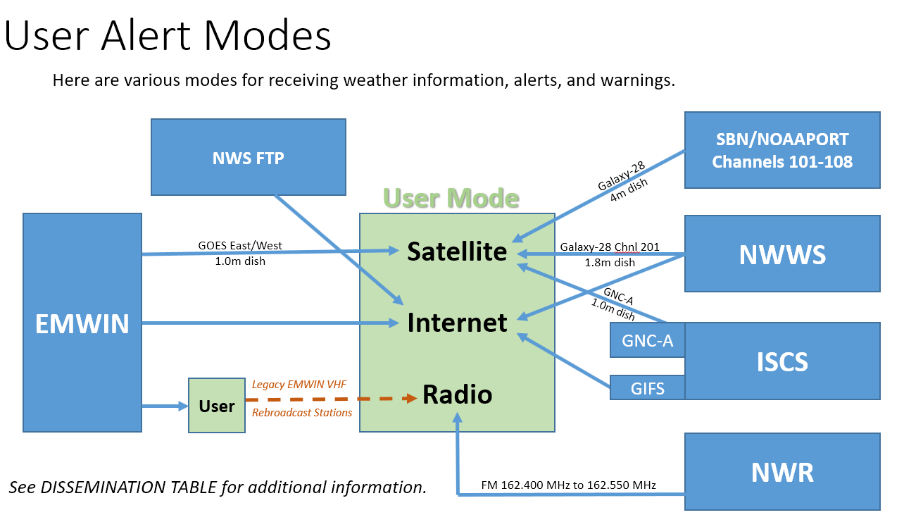
| Click on system name to see additional detail. | |
|
|
NWR | NWWS | EMWIN | ISCS | FTP Anonymous | SBN/NOAAPORT | |||||||||||||
| Satellite | see NWWS or SBN/NOAAPORT | SBN/NOAAPORT Channel 201 |
GOES-East (19) Channels: |
|
NO | Channel 101-108 | |||||||||||||
| Internet |
Check with local WFO webpages for NWR audio links. Commercially available apps carry NWR audio. |
XMPP One-way chatroom requires NWS issued User_ID and password with XMPP chat/reader software program (Java, Pidgin, Gajim, or similar) –[See also Weather API] |
FTP server | GIFS | < 24-hour connection [See also Weather API] |
[See also Weather API] | |||||||||||||
| FM Radio | 162.400 MHz, 162.425 MHz, 162.450 MHz, 162.475 MHz, 162.500 MHz, 162.525 MHz, and 162.550 MHz | see NWR |
User Rebroadcast Capability 163.300 MHz, |
NO | NO | ||||||||||||||
| Can be used to activate the local Emergency Alert System (EAS) |
YES | YES | NO | NO | YES | ||||||||||||||
| CAP formatted text products available in Product Stream XOAK57 KWBC XOAK58 KWBC XOAK59 KWBC XOCA52 KWBC XOGM50 KWBC XOHW KWBC XOUS51 KWBC XOUS52 KWBC XOUS53 KWBC XOUS54 KWBC XOUS55 KWBC XOUS56 KWBC XOXX55 KWBC XOZS50 KWBC |
Not available | Not available | Not available | Not available | YES | YES |
| Abbreviation | Short for | Abbreviation | Short for |
|---|---|---|---|
| AFS | Analyze, Forecast and Support | NOAA | National Oceanic Atmospheric Administration |
| AWIPS | Advanced Weather Interactive Processing System | NSD | NOAA Staff Directory |
| BMH | Broadcast Message Handler | NTIA | National Telecommunications and Information Administration |
| CAP | Common Alerting Protocol | NWA | National Weather Association |
| CLA (note 1) | Climatological Report (Annual) | NWR | NOAA Weather Radio |
| CLI (note 1) | Climatological Report (Daily) | NWS | National Weather Service |
| CLM (note 1) | Climatological Report (Monthly) | NWSI | National Weather Service Instruction |
| COG | Collaborative Operating Group (FEMA) | NWSTG | National Weather Service Telecommunications Gateway |
| CONUS | Continental United States | NWWS | NOAA Weather Wire System |
| DHS | Department of Homeland Security | OBS | Office of Observations |
| DIS or DISS | Office of Dissemination | OI | Open Interface |
| DOC | Department of Commerce | PCA | Partial County Alerting |
| DSB | Dissemination Systems Branch | PID | Packet Identifier |
| EDT | Eastern Daylight Time | PNS (note 1) | Public Information Statement |
| EMWIN | Emergency Managers Weather Information Network | RMTN | Regional Meteorological Telecommunications Network |
| EST | Eastern Standard Time | RSS | Really Simple Syndication |
| ET | Eastern Time | SAME | Specific Area Message Encoding |
| EWW (note 1) | Extreme Wind Warning | SBN | Satellite Broadcast Network |
| FAQ | Frequently Asked Questions | SDM | Senior Duty Meteorologist |
| FCC | Federal Communications Commission | SCN | Service Change Notice |
| FEMA | Federal Emergency Management Agency | SMS | Short Message Service |
| FM | Frequency Modulation | TAF (note 1) | Terminal Aerodrome Forecasts |
| FTP | File Transfer Protocol | TBD | To Be Determined |
| GIFS | Global Telecommunications System (GTS) Internet File Service | TSU (note 1) | Tsunami Watch/Warning |
| GOES | Geostationary Operational Environmental Satellite | USCG | U.S. Coast Guard |
| HF | High Frequency | USGS | United States Geological Survey |
| HLS (note 1) | Hurricane Local Statement | UTC | Coordinated Universal Time |
| HRIT | High Rate Information Transmission | UGC | University Grants Commission |
| IPAWS | Integrated Public Alert and Warning System | VHF | Very High Frequency |
| ISCS | International Services and Communication Systems | VPN | Virtual Private Network |
| LDM | Local Data Manager | WFO | Weather Forecast Office |
| LNB | Low Noise Block down converter | WSH | Weather Service Headquarters |
| LRIT | Low Rate Information Transmission | XML | eXtensible Markup Language |
| LSR (note 1) | Local Storm Report | XMPP | Extensible Messaging and Presence Protocol |
| MHZ | MegaHertz | Z | Zulu |
| NCO | NCEP Central Operations | ZFP (note 1) | Zone Forecast Point |
| NIDS | NWS Internet Dissemination System |
US Dept of Commerce
National Oceanic and Atmospheric Administration
National Weather Service
National Weather Service Dissemination
1325 East West Highway
Silver Spring, MD 20910
Comments? Questions? Please Contact Us.