Overview
|
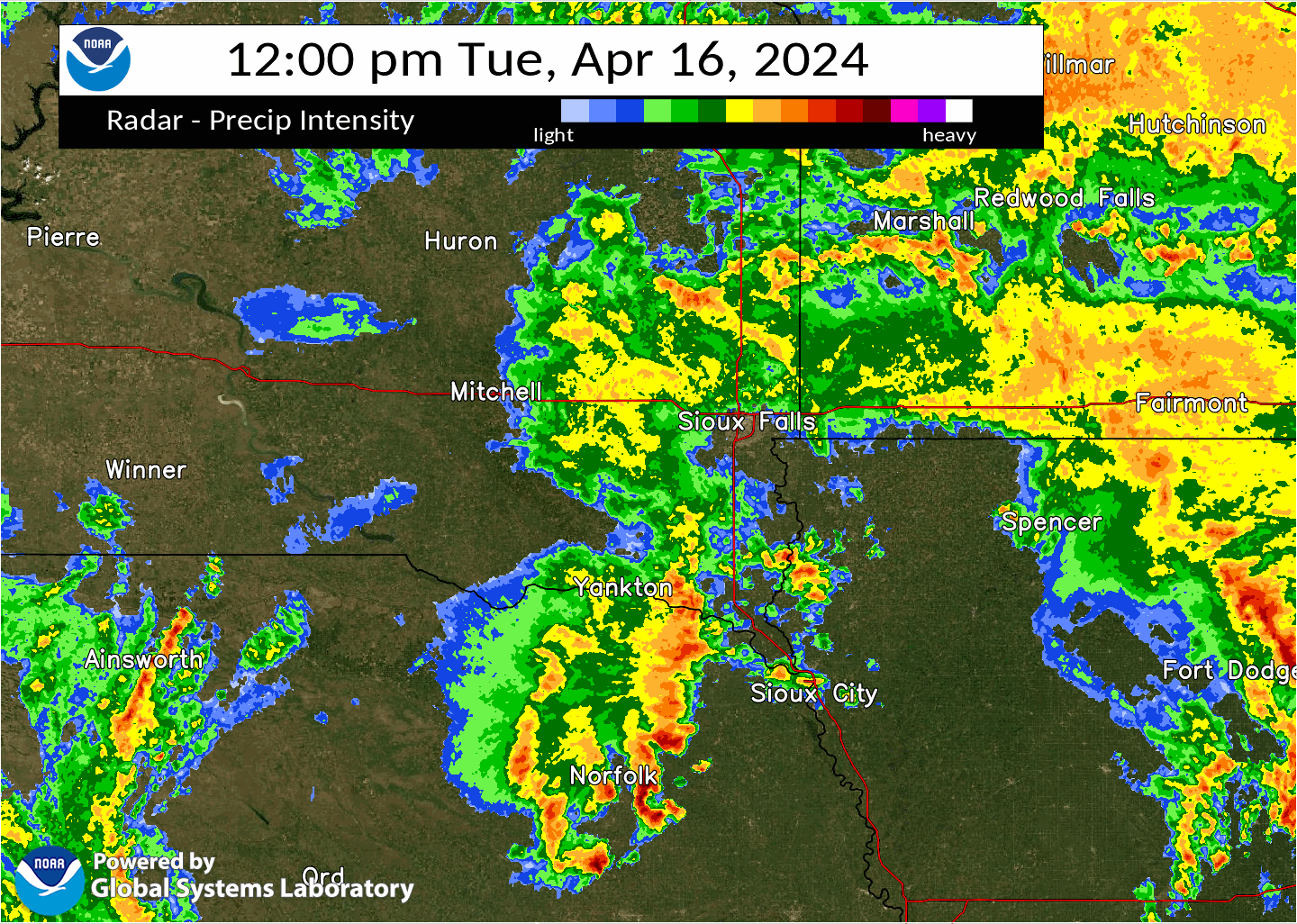
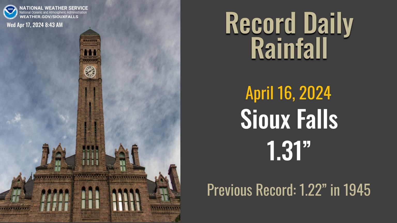
Scattered showers and thunderstorms prevailed across the region Tuesday, April 16 as a pronounced upper level low lifted northeastward across the Nebraska/South Dakota/Iowa border. While pea to quarter size hail was reported in areas near Sioux City, IA, this event primarily resulted in widespread rainfall and brief tornadoes/funnels. No injuries or deaths were reported. In addition to this, Sioux Falls set a new daily rainfall record of 1.31 inches, which broke the previous record of 1.22 inches set in 1945. |
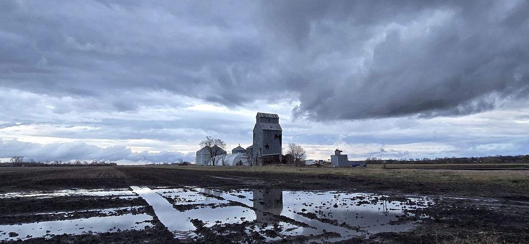 Water logged cornfield in Renner, SD (Credit: Jeff Van Horn) |
Tornadoes
|
Tornado - Hinton
Track Map 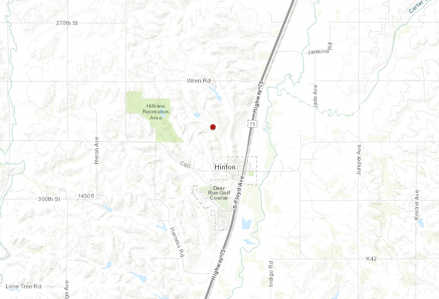 
Downloadable KMZ File |
||||||||||||||||
|
Tornado - Le Mars
Track Map 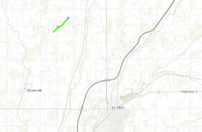
Downloadable KMZ File |
||||||||||||||||
|
||||||||||||||||
|
Tornado - North of Struble
Track Map 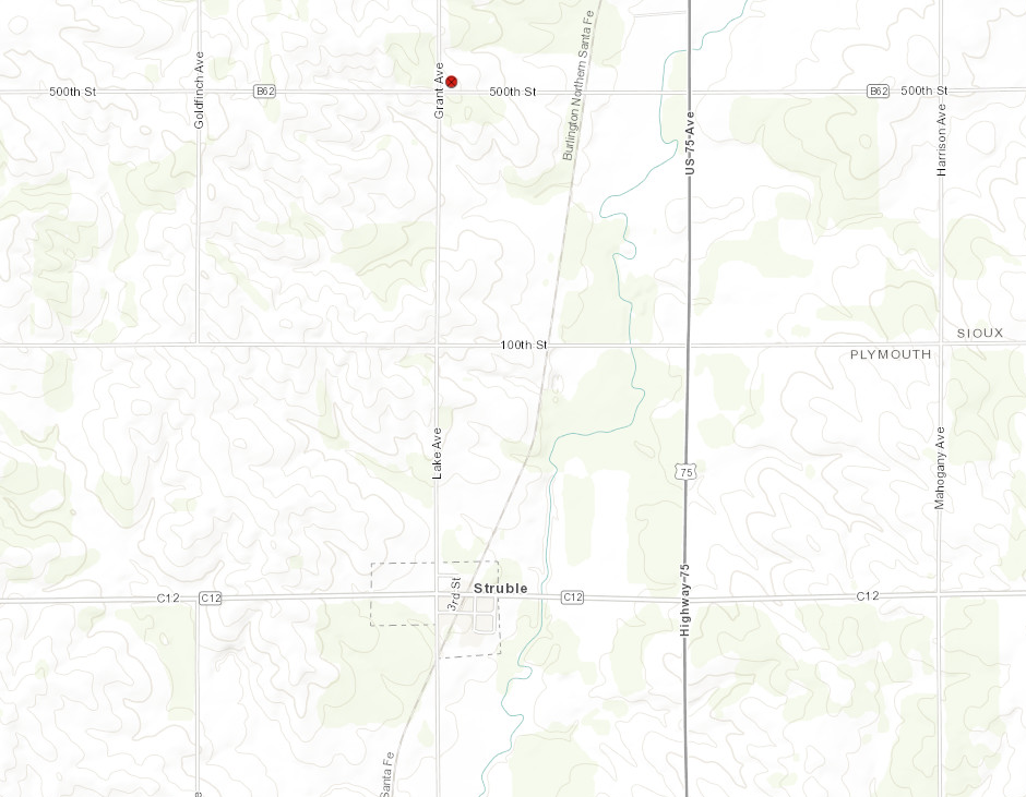
Downloadable KMZ File |
||||||||||||||||
|
Tornado - Sioux Center #1
Track Map 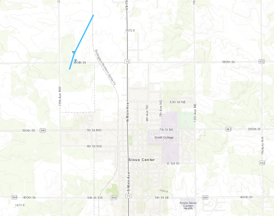
Downloadable KMZ File |
||||||||||||||||
|
||||||||||||||||
|
Tornado - Sioux Center #2
Track Map 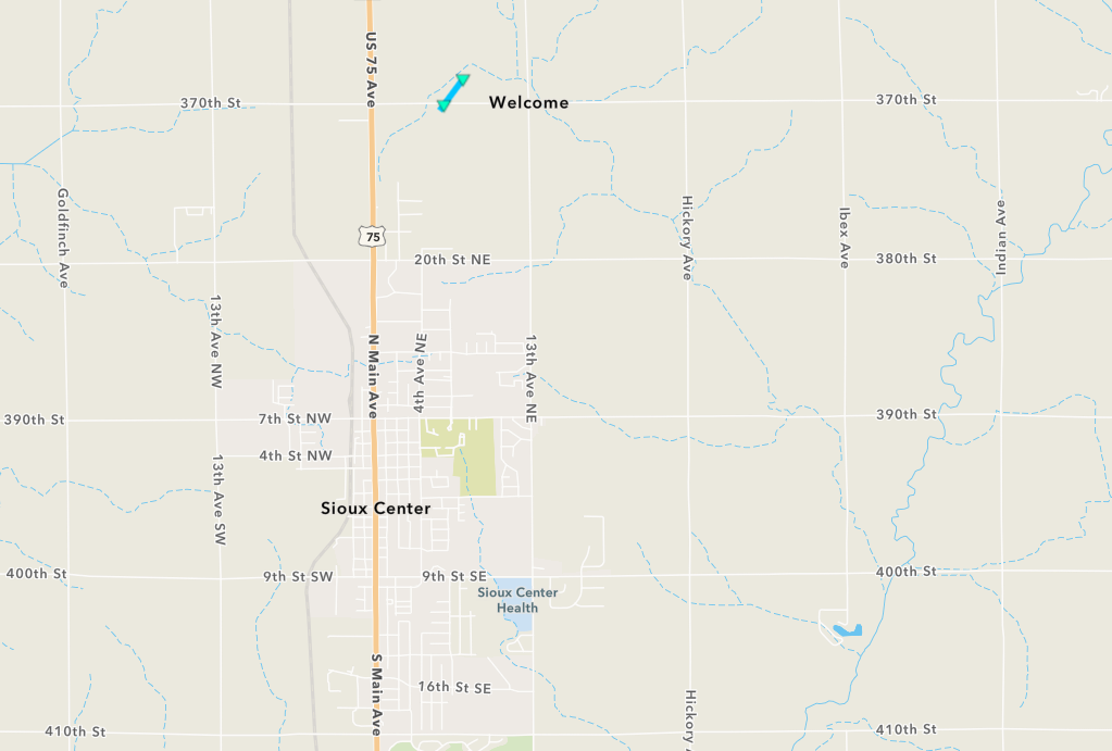
Downloadable KMZ File |
||||||||||||||||
|
Tornado - South of George
Track Map 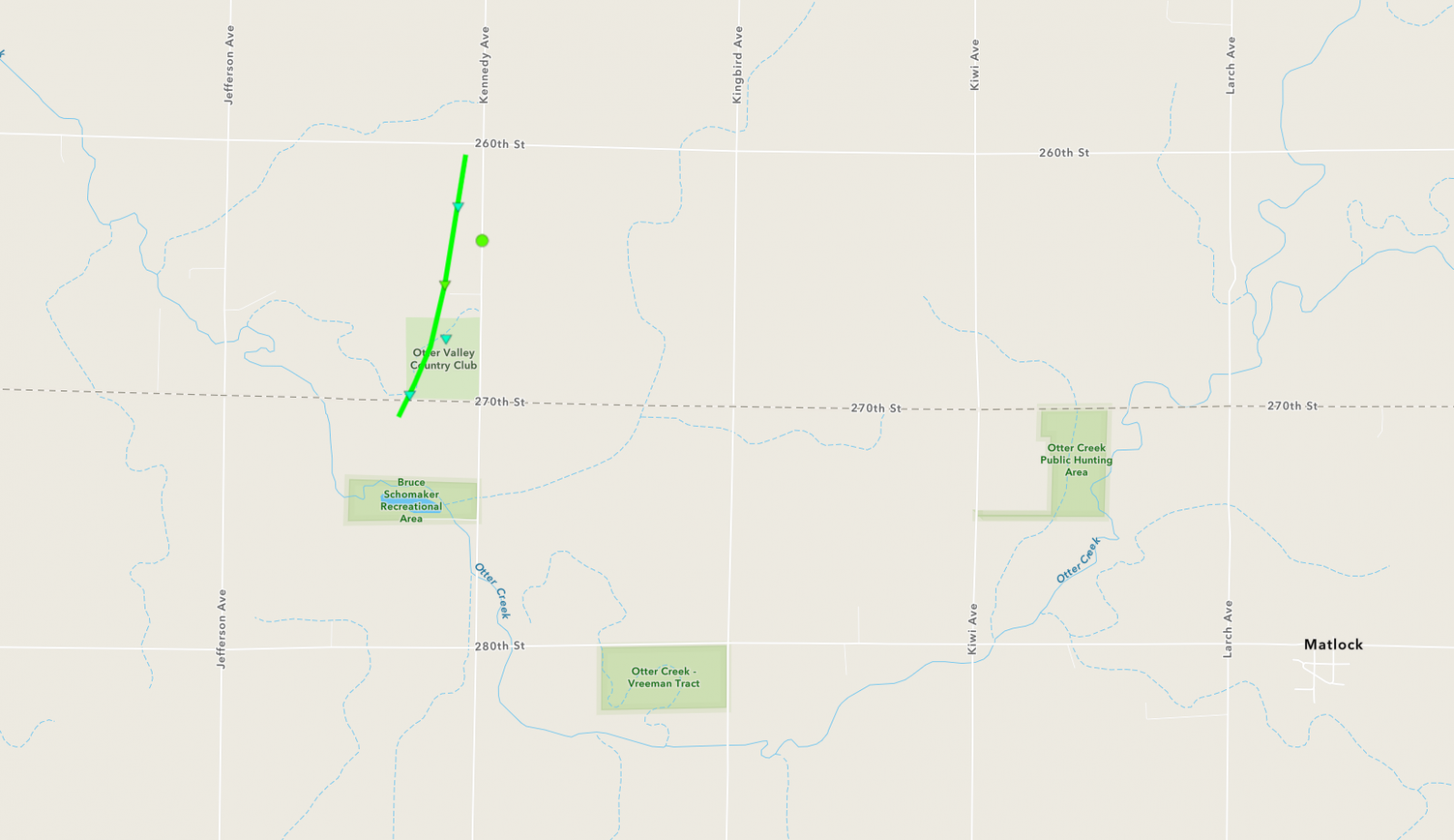
Downloadable KMZ File |
||||||||||||||||
|
||||||||||||||||
The Enhanced Fujita (EF) Scale classifies tornadoes into the following categories:
| EF0 Weak 65-85 mph |
EF1 Moderate 86-110 mph |
EF2 Significant 111-135 mph |
EF3 Severe 136-165 mph |
EF4 Extreme 166-200 mph |
EF5 Catastrophic 200+ mph |
 |
|||||
Photos & Video
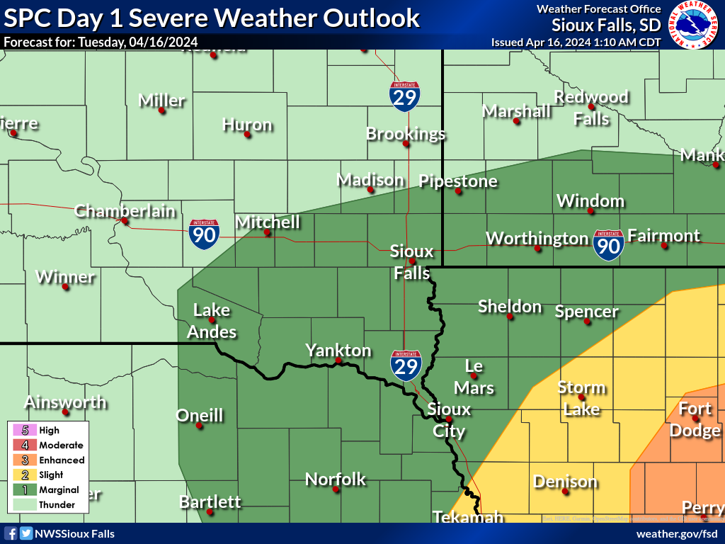
Storm Prediction Center Day 1 Outlooks
 |
 |
 |
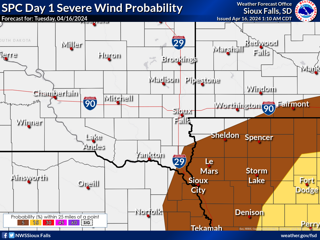 |
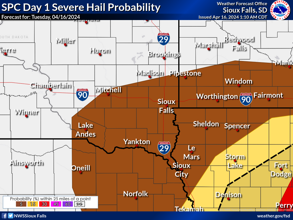
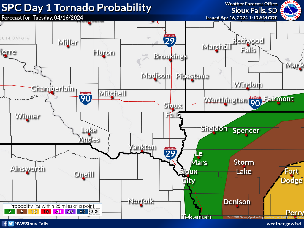
| SPC Day 1 Severe Weather Outlook | SPC Day 1 Severe Hail Probability | SPC Day 1 Severe Tornado Probability | SPC Day 1 Severe Wind Probability |
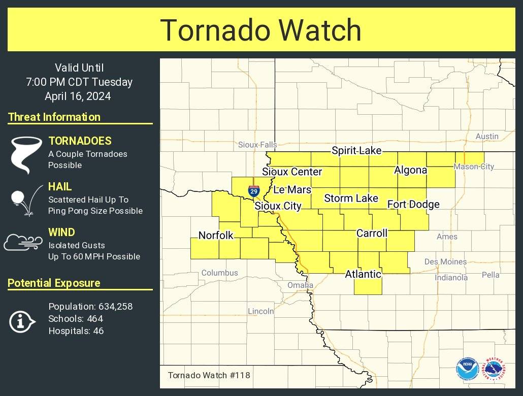
Radar, Headlines, and Tornado Locations
 |
 |
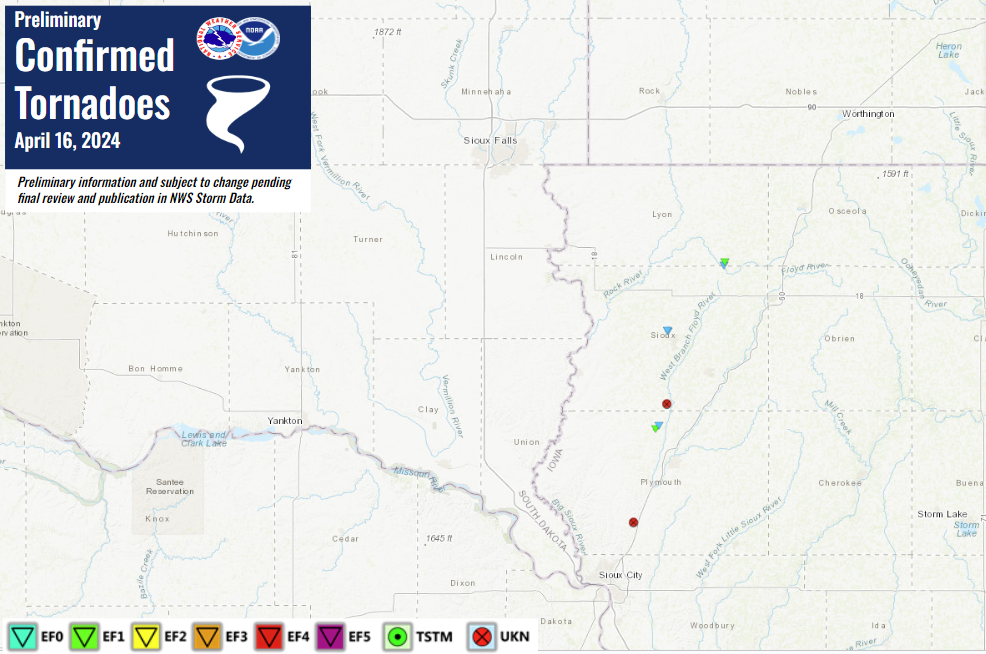 |
| MRMS Reflectivity Loop (12 PM - 6 PM Tuesday April 16, 2024) | Tornado Watch issued on April 16, 2024 | Preliminary Confirmed Tornadoes on April 16, 2024 |
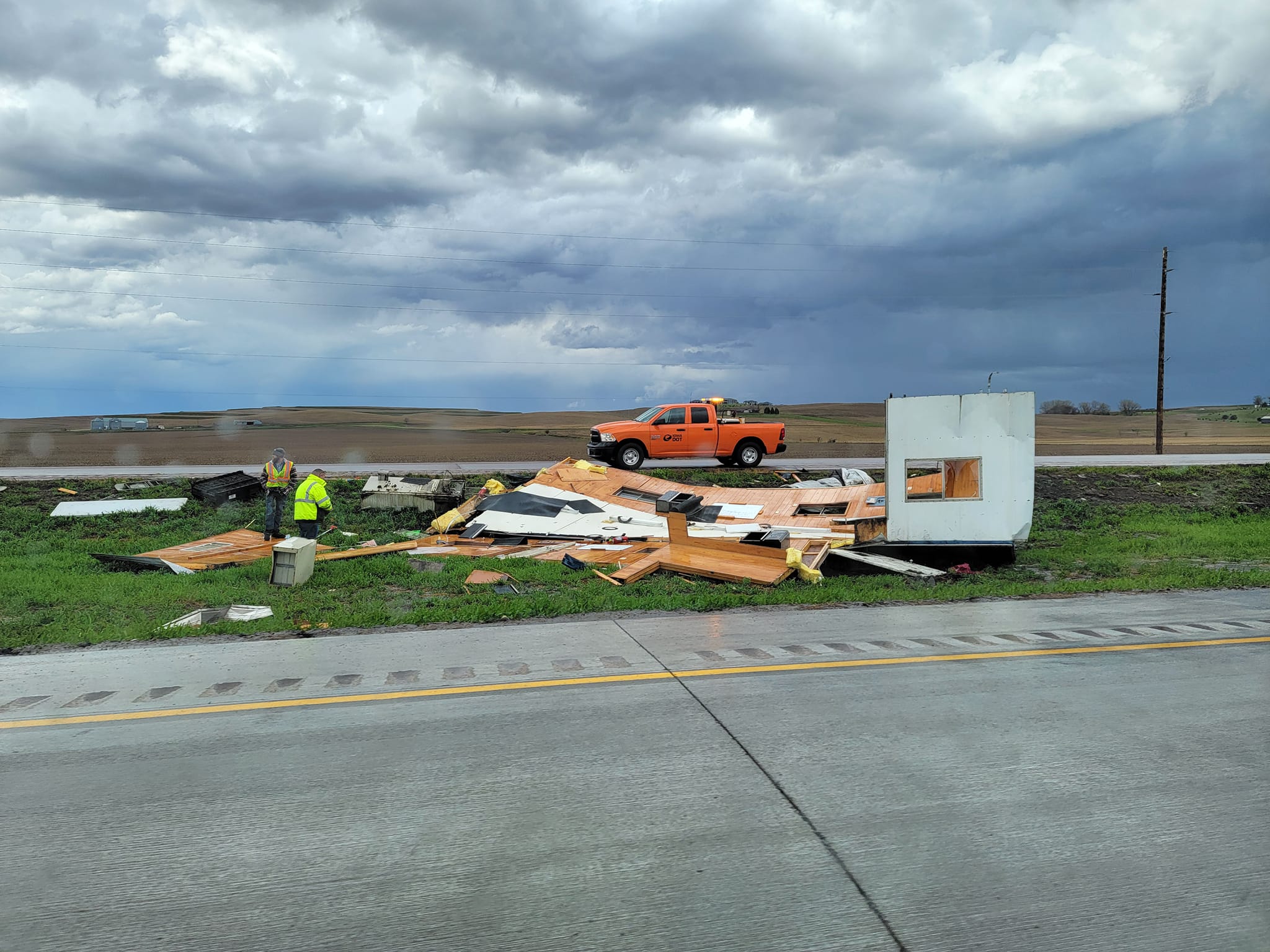
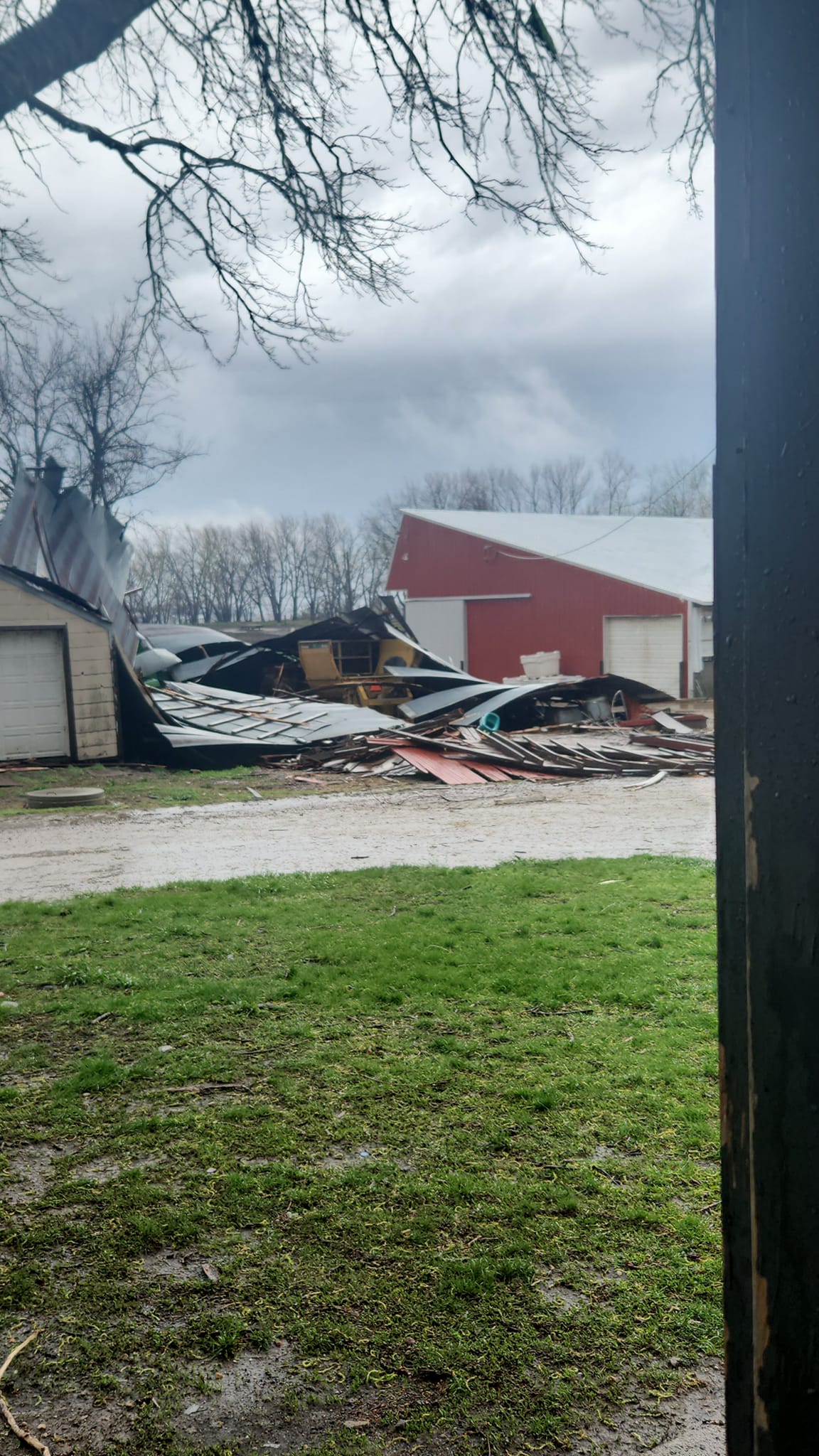
Photos
 |
 |
 |
 |
| Pea to Quarter Size Hail north of Sioux City, IA (Maria Curtis) |
Trailer home destroyed and blown into ditch along Highway 75 near Merrill, IA (Quincy Kolker) |
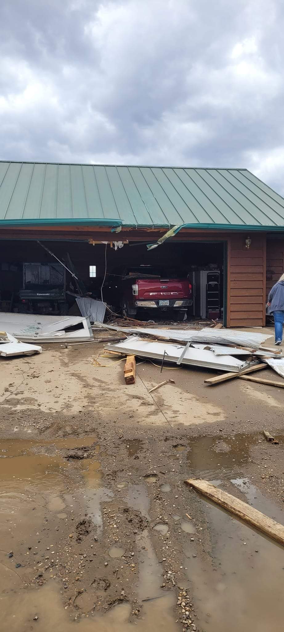
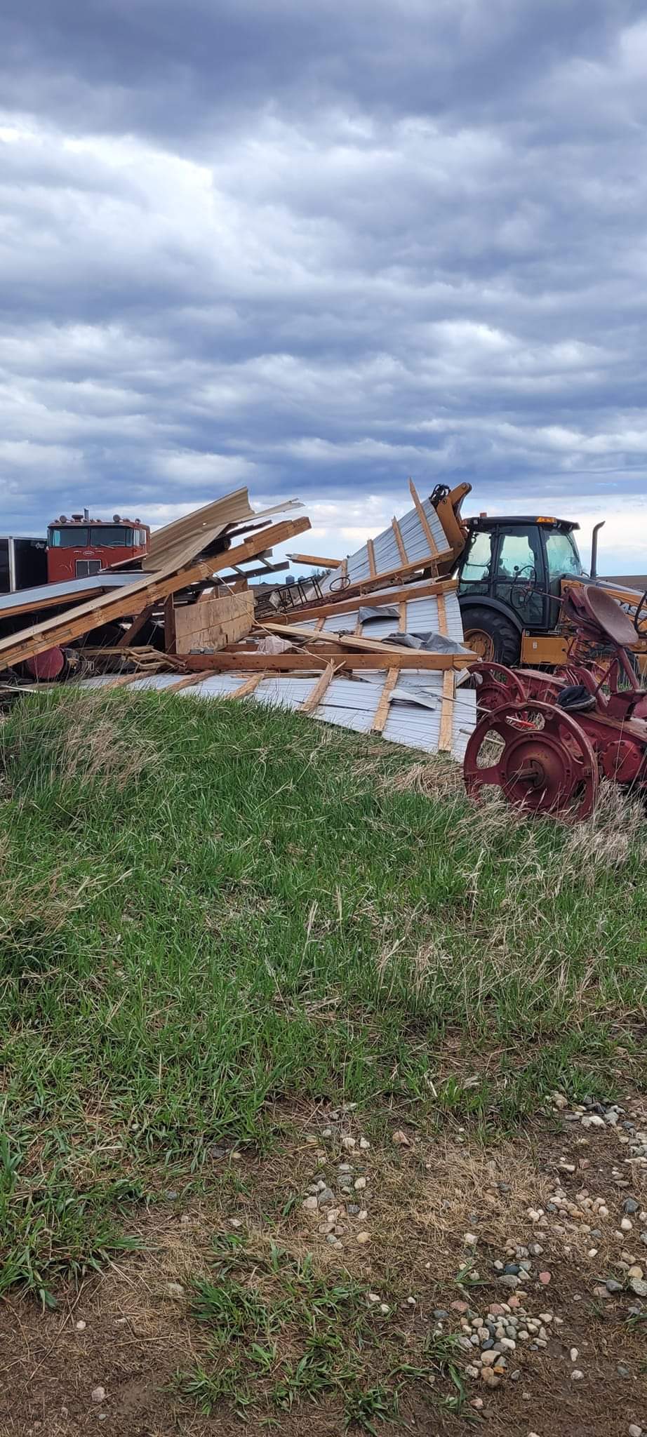
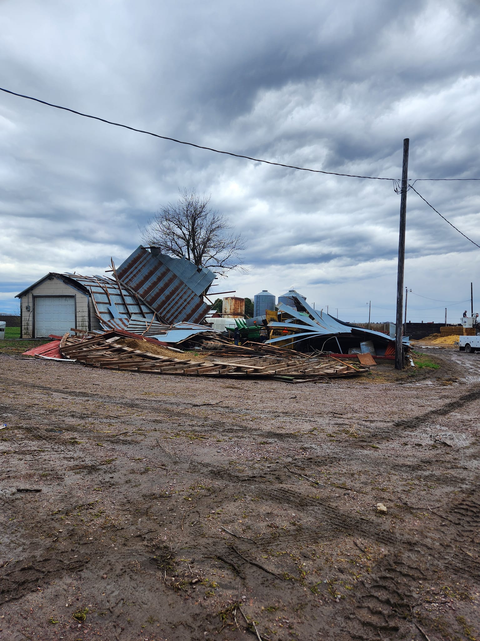
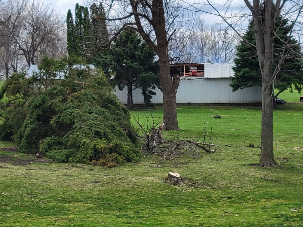
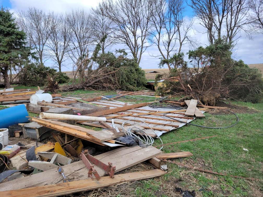
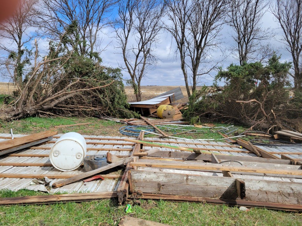
Farmstead damage NW of Sioux Center. IA (Kim Bleyenberg) |
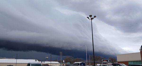
Shelf Cloud in Windom, MN (Johanna Shearer) |
Rain Reports
 |
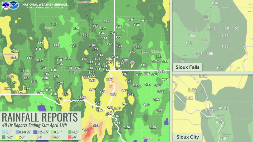 |
| Record Daily Rainfall broken in Sioux Falls | 48 Hour Rainfall Reports Ending at 7 AM April 17, 2024 |
Public Information Statement
National Weather Service Sioux Falls SD
1223 PM CDT Wed Apr 17 2024

...48 HOUR RAIN REPORTS ENDING MORNING OF APRIL 17TH...

Location                     Amount    Time/Date       Provider

...Iowa...

...Buena Vista County...
Storm Lake                   0.99 in   0800 AM 04/17   COOP
0.8 SW Linn Grove            0.61 in   1200 PM 04/17   COOP

...Cherokee County...
0.9 NE Cherokee              1.13 in   0800 AM 04/17   COOP

...Clay County...
Spencer 7.0 S                0.78 in   0751 AM 04/17   COCORAHS
Spencer Municipal Airport    0.62 in   1153 AM 04/17   ASOS

...Dickinson County...
Lake Park 0.2 N              0.85 in   0800 AM 04/17   COCORAHS
0.6 E Spirit Lake            0.84 in   0700 AM 04/17   COOP
Lake Park 3.2 SSE            0.69 in   0700 AM 04/17   COCORAHS
TERRIL                       0.65 in   1209 PM 04/17   CWOP

...Ida County...
Arthur 3.7 SSW               0.69 in   0502 AM 04/17   COCORAHS

...Lyon County...
Rock Rapids 7.7 WNW          1.93 in   0900 AM 04/17   COCORAHS
Rock Rapids                  1.74 in   0800 AM 04/17   COOP
5 SSW Ellsworth              1.44 in   1205 PM 04/17   AWS
4 SW George                  1.35 in   1205 PM 04/17   AWS

...OBrien County...
Sheldon                      1.23 in   0700 AM 04/17   COOP
Hartley                      0.72 in   1200 PM 04/17   CWOP

...Osceola County...
Sibley                       0.92 in   0800 AM 04/17   COOP
Ocheyedan                    0.86 in   0700 AM 04/17   COCORAHS

...Plymouth County...
Remsen                       2.82 in   0700 AM 04/17   COOP
Le Mars                      2.51 in   0700 AM 04/17   COOP
Loess Hills Tnc Broken       2.46 in   1111 AM 04/17   RAWS
Le Mars 1.0 E                2.42 in   0530 AM 04/17   COCORAHS
6 NNE Jefferson              2.08 in   0851 AM 04/17   COCORAHS
6.2 NW Hinton                2.08 in   1145 AM 04/17   UCOOP

...Sioux County...
Orange City 0.4 WNW          2.00 in   0800 AM 04/17   COCORAHS
Orange City 1.2 SSE          1.99 in   0809 AM 04/17   COCORAHS
Orange City                  1.87 in   0700 AM 04/17   COOP
Hawarden                     1.80 in   1205 PM 04/17   CWOP
Sioux Center                 1.68 in   1200 PM 04/17   CWOP

...Woodbury County...
1.4 SE North Sioux City      1.43 in   1130 AM 04/17   HADS
Sioux City                   1.01 in   0600 AM 04/17   COOP
1 ENE Dakota City            0.99 in   1208 PM 04/17   AWS
Sioux Gateway Airport        0.97 in   1152 AM 04/17   ASOS
SIOUX CITY                   0.93 in   1200 PM 04/17   CWOP
3.4 N Hornick                0.70 in   0700 AM 04/17   COOP

...Minnesota...

...Cottonwood County...
2.6 NW Windom                0.32 in   1115 AM 04/17   COOP

...Jackson County...
Lakefield 7.8 N              1.27 in   0700 AM 04/17   COCORAHS
Lakefield 0.9 NNE            1.20 in   0700 AM 04/17   COCORAHS
Jackson 4.6 NNW              0.93 in   0800 AM 04/17   COCORAHS
Okabena 3.2 S                0.70 in   0700 AM 04/17   COCORAHS

...Lincoln County...
Hendricks 8.0 SE             1.38 in   0700 AM 04/17   COCORAHS
Pipestone 14.3 N             1.20 in   0700 AM 04/17   COCORAHS
Ivanhoe                      0.77 in   1205 PM 04/17   CWOP

...Lyon County...
Ghent 2.8 ENE                2.18 in   0700 AM 04/17   COCORAHS
Marshall                     2.08 in   0800 AM 04/17   COOP
4 S Cottonwood               1.98 in   0800 AM 04/17   COCORAHS
Marshall 3.7 W               1.71 in   0700 AM 04/17   COCORAHS
Marshall Municipal Airport   1.58 in   1156 AM 04/17   AWOS
Minneota                     1.46 in   0900 AM 04/17   COCORAHS
Russell                      1.21 in   1130 AM 04/17   HADS

...Murray County...
Chandler 2.7 SSE             1.49 in   0700 AM 04/17   COCORAHS
Slayton 0.8 SSW              1.21 in   0700 AM 04/17   COCORAHS
Slayton Municipal Airport    1.08 in   1153 AM 04/17   AWOS
Fulda 0.3 NNE                1.01 in   0700 AM 04/17   COCORAHS

...Nobles County...
Adrian 1.5 NW                1.90 in   0700 AM 04/17   COCORAHS
Worthington 2 NNE            1.12 in   0700 AM 04/17   COOP
Worthington 1.9 SW           1.03 in   0654 AM 04/17   COCORAHS
Worthington 4.0 S            0.89 in   0700 AM 04/17   COCORAHS
Brewster 0.1 SW              0.78 in   0700 AM 04/17   COCORAHS

...Pipestone County...
Pipestone                    1.50 in   1130 AM 04/17   COOP
Redstone RAWS                1.38 in   1121 AM 04/17   RAWS

...Rock County...
Hills 0.2 NW                 1.72 in   0700 AM 04/17   COCORAHS
Beaver Creek 5.8 NW          1.66 in   0700 AM 04/17   COCORAHS
Luverne 0.6 NNE              1.47 in   0900 AM 04/17   COCORAHS
0.9 NE Luverne               1.17 in   1030 AM 04/17   COOP

...Nebraska...

...Dakota County...
1.4 N South Sioux City       0.90 in   1200 PM 04/17   HADS
South Sioux City             0.85 in   1200 PM 04/17   CWOP

...Dixon County...
Concord 4.23 S               3.02 in   0700 AM 04/17   COCORAHS
Newcastle                    3.02 in   0600 AM 04/17   COOP
Ponca 2.5 NW                 2.42 in   0800 AM 04/17   COCORAHS

...South Dakota...

...Aurora County...
Plankinton 3.8 W             1.35 in   0700 AM 04/17   COCORAHS
Stickney 3.8 SW              1.23 in   0700 AM 04/17   COCORAHS
SD RWIS Plankinton           0.82 in   1202 PM 04/17   SDDOT

...Beadle County...
Huron 6.8 NNE                1.13 in   0700 AM 04/17   COCORAHS
Huron Regional Airport       1.03 in   1155 AM 04/17   ASOS

...Bon Homme County...
Springfield 7.6 WNW          1.70 in   0700 AM 04/17   COCORAHS
Tyndall                      1.65 in   0800 AM 04/17   COOP
Avon 2.1 W                   1.33 in   0700 AM 04/17   COCORAHS

...Brookings County...
Bruce 0.2 SSW                2.00 in   0700 AM 04/17   COCORAHS
Bruce 4.1 NE                 1.88 in   0700 AM 04/17   COCORAHS
Aurora 7.5 N                 1.84 in   0700 AM 04/17   COCORAHS
Brookings 6.5 NNW            1.79 in   0700 AM 04/17   COCORAHS
Brookings 1.6 S              1.74 in   0700 AM 04/17   COCORAHS
Brookings 2.8 SSW            1.72 in   0748 AM 04/17   COCORAHS
Brookings 0.2 SSW            1.72 in   0700 AM 04/17   COCORAHS
Astoria 2.2 SSE              1.69 in   0700 AM 04/17   COCORAHS
Aurora 0.3 NE                1.66 in   0700 AM 04/17   COCORAHS
White 0.4 WNW                1.65 in   0800 AM 04/17   COCORAHS
Brookings 1.0 S              1.65 in   0700 AM 04/17   COCORAHS
Volga 0.5 WSW                1.65 in   0700 AM 04/17   COCORAHS
Bruce 5.3 W                  1.58 in   0800 AM 04/17   COCORAHS
Brookings Municipal Airport  1.58 in   1156 AM 04/17   AWOS
Elkton                       1.56 in   1205 PM 04/17   CWOP
Brookings 1.4 SW             1.56 in   0800 AM 04/17   COCORAHS
Brookings 2 NE               1.54 in   0800 AM 04/17   COOP
Brookings 1.4 NW             1.53 in   0600 AM 04/17   COCORAHS
Brookings 5.3 N              1.52 in   0700 AM 04/17   COCORAHS
Aurora 0.3 NNE               1.44 in   0718 AM 04/17   COCORAHS
Toronto 3.9 SW               1.42 in   0700 AM 04/17   COCORAHS
Elkton                       1.17 in   1200 PM 04/17   CWOP

...Brule County...
Chamberlain                  2.62 in   0700 AM 04/17   COCORAHS
Chamberlain 7.5 NNE          2.61 in   0700 AM 04/17   COCORAHS
Chamberlain Municipal Airpor 2.45 in   1155 AM 04/17   ASOS
SD RWIS Kimball              1.82 in   1202 PM 04/17   SDDOT
Kimball 3.9 ENE              1.58 in   0700 AM 04/17   COCORAHS

...Charles Mix County...
Academy 2 NE                 1.85 in   0900 AM 04/17   COOP
Lake Andes RAWS              1.31 in   1141 AM 04/17   RAWS
SD RWIS WAGNER               1.21 in   1201 PM 04/17   SDDOT
Dante 3.1 S                  1.18 in   0700 AM 04/17   COCORAHS
7.6 SW Platte                1.17 in   1115 AM 04/17   HADS
Wagner 0.8 NW                0.98 in   0700 AM 04/17   COCORAHS
SD RWIS Platte-Winner Bridge 0.90 in   1201 PM 04/17   SDDOT

...Clay County...
Vermillion 1.4 SE            2.83 in   0600 AM 04/17   COCORAHS
Vermillion 1.9 N             2.25 in   0800 AM 04/17   COCORAHS
5.9 SE Centerville           1.65 in   0800 AM 04/17   COOP

...Davison County...
Mitchell 1.0 SE              1.36 in   0700 AM 04/17   COCORAHS
Mitchell 7.3 S               1.26 in   0700 AM 04/17   COCORAHS
Mitchell                     1.12 in   0700 AM 04/17   COCORAHS
Mitchell Municipal Airport   0.81 in   1153 AM 04/17   ASOS

...Douglas County...
Dimock 10.2 W                1.48 in   0700 AM 04/17   COCORAHS
Corsica 0.1 SSE              1.15 in   0800 AM 04/17   COCORAHS
Armour 4.6 W                 1.08 in   0700 AM 04/17   COCORAHS
Corsica 4.3 W                0.98 in   0800 AM 04/17   COCORAHS

...Gregory County...
Dallas 8.8 S                 2.99 in   0700 AM 04/17   COCORAHS
SD RWIS Dixon                2.62 in   1201 PM 04/17   SDDOT
Gregory 8.7 N                2.10 in   0700 AM 04/17   COCORAHS
Bonesteel 0.1 S              1.94 in   0800 AM 04/17   COCORAHS
2 N Bonesteel                1.54 in   1205 PM 04/17   AWS
Gregory                      1.50 in   0700 AM 04/17   HADS
Gregory 4.3 E                1.40 in   0700 AM 04/17   COCORAHS
Burke 10.5 SSE               1.14 in   0700 AM 04/17   COCORAHS
Herrick 8.2 SSW              1.05 in   0700 AM 04/17   COCORAHS
Pickstown 4 SSW              0.90 in   0700 AM 04/17   COOP

...Hanson County...
SD RWIS Alexandria           1.87 in   1201 PM 04/17   SDDOT
Alexandria 7.5 SSE           1.38 in   0931 AM 04/17   COCORAHS
Alexandria 6.4 N             1.15 in   0700 AM 04/17   COCORAHS

...Hutchinson County...
Parkston 6.6 S               1.82 in   0700 AM 04/17   COCORAHS
Parkston 6.5 WSW             1.31 in   0700 AM 04/17   COCORAHS
Emery 10.8 S                 1.11 in   0600 AM 04/17   COCORAHS
SD RWIS Tripp                0.67 in   1200 PM 04/17   SDDOT
4.3 SE Olivet                0.60 in   1130 AM 04/17   COOP

...Jerauld County...
Wessington Springs           1.98 in   0700 AM 04/17   COOP
Wessington Springs 9.3 SSW   1.46 in   0630 AM 04/17   COCORAHS

...Kingsbury County...
Oldham 0.9 E                 2.55 in   0700 AM 04/17   COCORAHS
De Smet 0.2 SSE              1.06 in   0700 AM 04/17   COCORAHS

...Lake County...
Madison 2SE                  1.37 in   0900 AM 04/17   COOP
Wentworth 4.7 SSW            1.33 in   0700 AM 04/17   COCORAHS
Madison 0.8 NE               1.26 in   0725 AM 04/17   COCORAHS

...Lincoln County...
Canton                       2.67 in   0615 AM 04/17   COOP
Harrisburg 0.7 NNE           1.79 in   0700 AM 04/17   COCORAHS
Harrisburg 0.8 NNE           1.66 in   0700 AM 04/17   COCORAHS
Sioux Falls 4.6 SSW          1.48 in   0700 AM 04/17   COCORAHS
Tea 1.1 NNW                  1.47 in   0700 AM 04/17   COCORAHS
Sioux Falls 3.6 SSE          1.41 in   0700 AM 04/17   COCORAHS
Sioux Falls 3.6 S            1.33 in   0700 AM 04/17   COCORAHS
Sioux Falls 4.5 SSW          1.17 in   0600 AM 04/17   COCORAHS
Sioux Falls 4.0 SSE          1.14 in   0700 AM 04/17   COCORAHS

...McCook County...
Montrose 3.1 SW              1.70 in   0800 AM 04/17   COCORAHS
Bridgewater                  1.67 in   0800 AM 04/17   COOP
Montrose 5.8 NW              1.66 in   0700 AM 04/17   COCORAHS
SD RWIS Montrose             1.61 in   1201 PM 04/17   SDDOT
Montrose 2.4 E               1.53 in   0700 AM 04/17   COCORAHS
Montrose                     1.50 in   0900 AM 04/17   COOP
Parker 7.2 N                 1.46 in   0700 AM 04/17   COCORAHS
Parker 9.7 N                 1.40 in   0700 AM 04/17   COCORAHS
Salem 5NE                    1.40 in   0700 AM 04/17   COOP
Canova                       1.27 in   1210 PM 04/17   CWOP

...Miner County...
Howard                       1.69 in   0756 AM 04/17   COOP
Howard 0.7 SSW               1.69 in   0800 AM 04/17   COCORAHS
Howard 5.3 W                 1.25 in   0700 AM 04/17   COCORAHS

...Minnehaha County...
EROS DATA CNTR SIOUX FALLS 1 1.98 in   1200 PM 04/17   HADS
4 ESE Sioux Falls            1.96 in   0800 AM 04/17   UCOOP
Sioux Falls 3.4 ESE          1.96 in   0700 AM 04/17   COCORAHS
5 W Garretson                1.93 in   0700 AM 04/17   COCORAHS
Sioux Falls 5.2 E            1.92 in   0700 AM 04/17   COCORAHS
Sioux Falls 5.0 SE ARPT      1.83 in   0700 AM 04/17   COCORAHS
Sioux Falls 3.3 E            1.81 in   0700 AM 04/17   COCORAHS
Garretson 5.8 WNW            1.65 in   0700 AM 04/17   COCORAHS
Sioux Falls 4.0 SE           1.65 in   0700 AM 04/17   COCORAHS
Dell Rapids 0.9 WNW          1.55 in   0600 AM 04/17   COCORAHS
Sioux Falls 4.9 WSW          1.52 in   0800 AM 04/17   COCORAHS
Sioux Falls 3.3 E            1.51 in   0630 AM 04/17   COCORAHS
Renner 4.1 NW                1.51 in   0700 AM 04/17   COCORAHS
Sioux Falls 1.6 SW           1.50 in   0700 AM 04/17   COCORAHS
Sioux Falls 3.7 WSW          1.50 in   1000 AM 04/17   COCORAHS
Colton 3.8 S                 1.49 in   0500 AM 04/17   COCORAHS
5 SSE Baltic                 1.45 in   1205 PM 04/17   AWS
Sioux Falls 1.9 SSW          1.43 in   0830 AM 04/17   COCORAHS
Sioux Falls 0.7 NE           1.42 in   0700 AM 04/17   COCORAHS
Garretson 7.3 WSW            1.42 in   0650 AM 04/17   COCORAHS
Sioux Falls 5.5 N            1.38 in   0700 AM 04/17   COCORAHS
Sioux Falls Airport          1.37 in   0600 AM 04/17   COOP
Hartford 0.5 N               1.34 in   0600 AM 04/17   COCORAHS
Hartford 6.4 S               1.31 in   0700 AM 04/17   COCORAHS
Sioux Falls 4.1 WSW          1.23 in   0700 AM 04/17   COCORAHS
Dell Rapids 7.6 W            1.13 in   0700 AM 04/17   COCORAHS

...Moody County...
Brookings 8.1 S              1.56 in   0730 AM 04/17   COCORAHS
Colman 10.6 N                1.47 in   0700 AM 04/17   COCORAHS
Flandreau                    1.40 in   0630 AM 04/17   COOP

...Sanborn County...
Forestburg 0.1 NE            1.08 in   0700 AM 04/17   COCORAHS
3.8 SE Forestburg            0.61 in   1115 AM 04/17   COOP

...Turner County...
SD RWIS IRENE                3.83 in   1200 PM 04/17   SDDOT
Hurley 0.2 S                 2.55 in   0600 AM 04/17   COCORAHS
Parker 6.8 WSW               1.81 in   0700 AM 04/17   COCORAHS
Marion 4.8 NNW               1.63 in   0800 AM 04/17   COCORAHS
3.7 NE Parker                0.96 in   1115 AM 04/17   UCOOP

...Union County...
Jefferson 2.1 WNW            2.62 in   0700 AM 04/17   COCORAHS
SD RWIS North Sioux City     2.60 in   1201 PM 04/17   SDDOT
Jefferson 2.9 SW             2.30 in   0700 AM 04/17   COCORAHS

...Yankton County...
Yankton 2 E                  2.24 in   0900 AM 04/17   COOP
Yankton 0.3 ENE              1.92 in   0700 AM 04/17   COCORAHS
Yankton Municipal Airport    1.76 in   1156 AM 04/17   AWOS
Yankton 9.1 W                1.51 in   0700 AM 04/17   COCORAHS
Yankton 8.1 W                1.30 in   0800 AM 04/17   COCORAHS
Yankton 4.1 SW               1.29 in   0640 AM 04/17   COCORAHS

Observations are collected from a variety of sources with varying
equipment and exposures. We thank all volunteer weather observers
for their dedication. Not all data listed are considered official.
 |
Media use of NWS Web News Stories is encouraged! Please acknowledge the NWS as the source of any news information accessed from this site. |
|


 Weather Story
 Weather Map
 Local Radar