Overview
|
A potent spring storm system moved through the Central and Northern Plains on Friday March 14 to Saturday March 15, 2025. On the warm side of the system, severe thunderstorms tracked through northwestern Iowa on the evening of Friday March 14. These storms produced thunderstorm wind gusts up to 60 mph. Moderate, to at times heavy, rain then overspread the area Thursday night. As colder air swept into the region, rain changed to snow or wintry mix from west to east into the early morning hours of Saturday March 15. The snow then continued into early Saturday afternoon, with heaviest snowfall occurring over southwestern Minnesota. In addition to the snow and light icing, northerly winds increased across the region, with gusts as high as 59 mph being reported. These winds in combination with falling snow resulted in significantly reduced visibility across portions of southwestern Minnesota on Saturday morning. |
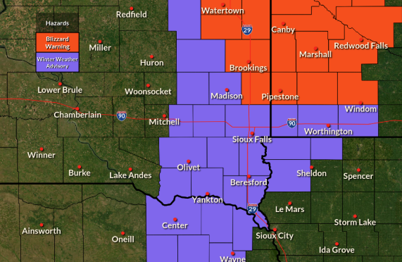 Winter Headlines in effect on March 15, 2025 |
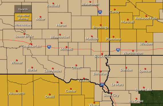
Wind:
Strong northwest winds developed on the back side of the system, making for a windy Saturday March 15th. Many sites received peak wind gusts of 50+ mph.
 |
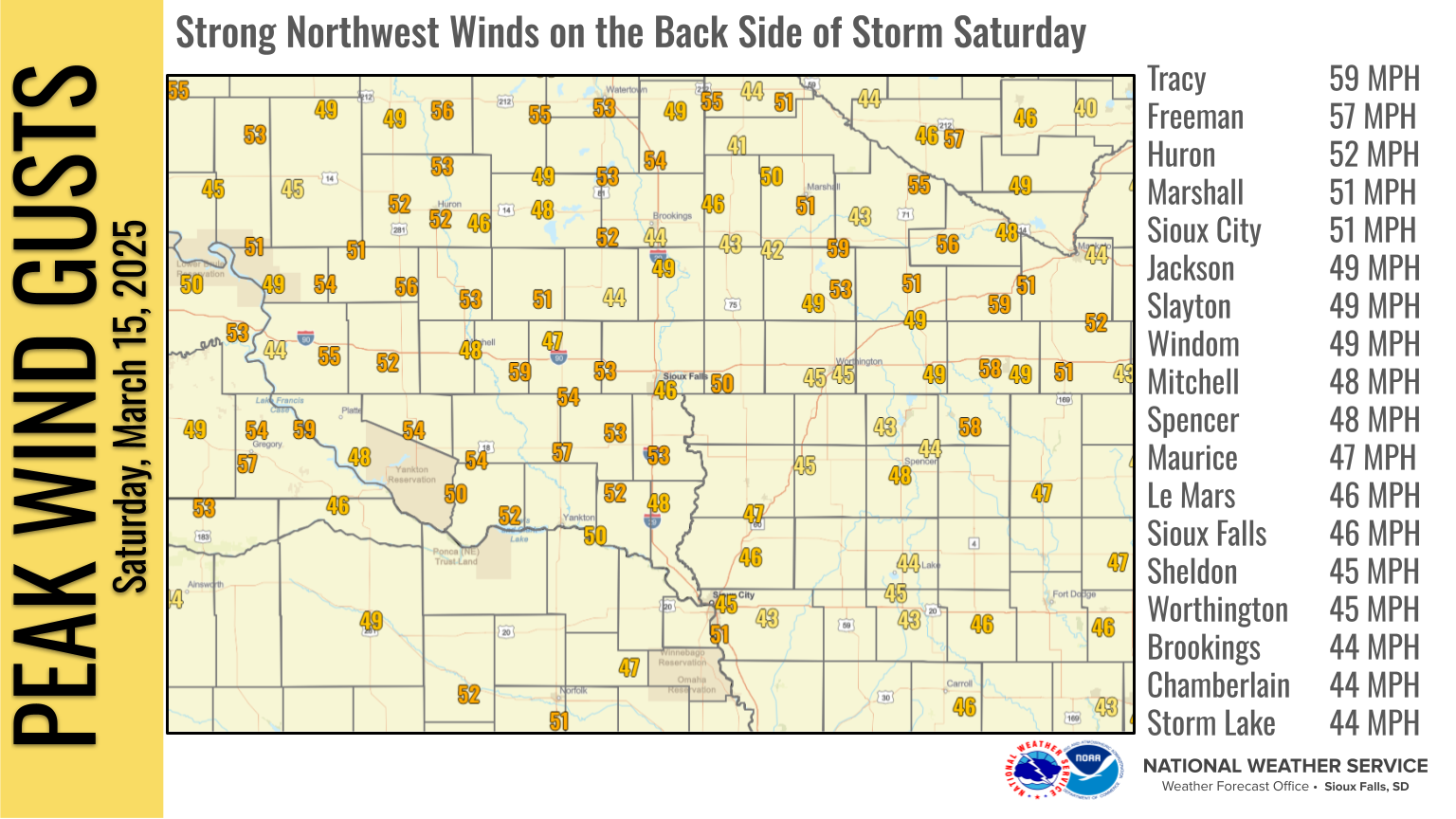 |
| Wind Headlines in effect on March 15, 2025 | Peak Wind Gusts from Saturday March 15th, 2025 |
Snow/Ice
Here's a look at snowfall amounts for the event. Most of the area saw less than two inches of snow.
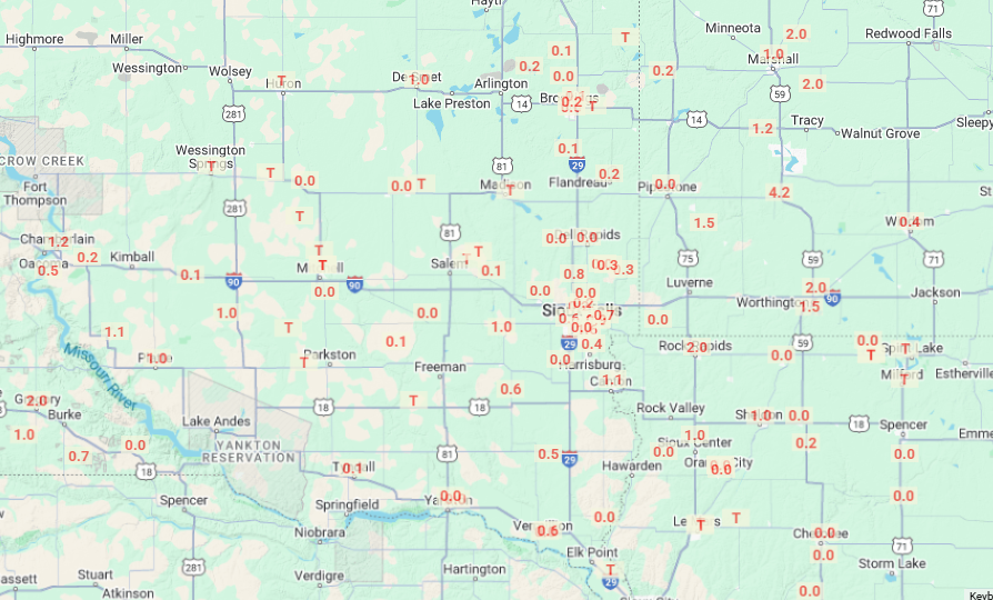 |
| Snowfall Totals for March 14th and 15th |
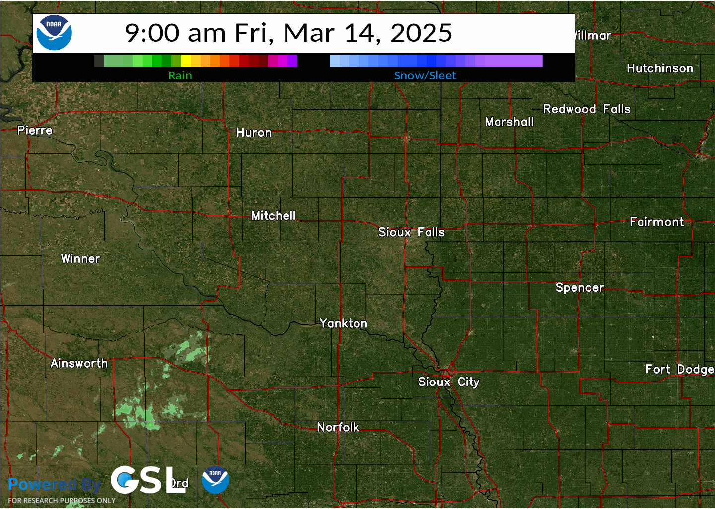
Radar
Here's a look at the radar through the event. Although not depicted well by the later loop (on the right), wintry mix including sleet was mixing in during the transition from rain to snow.
 |
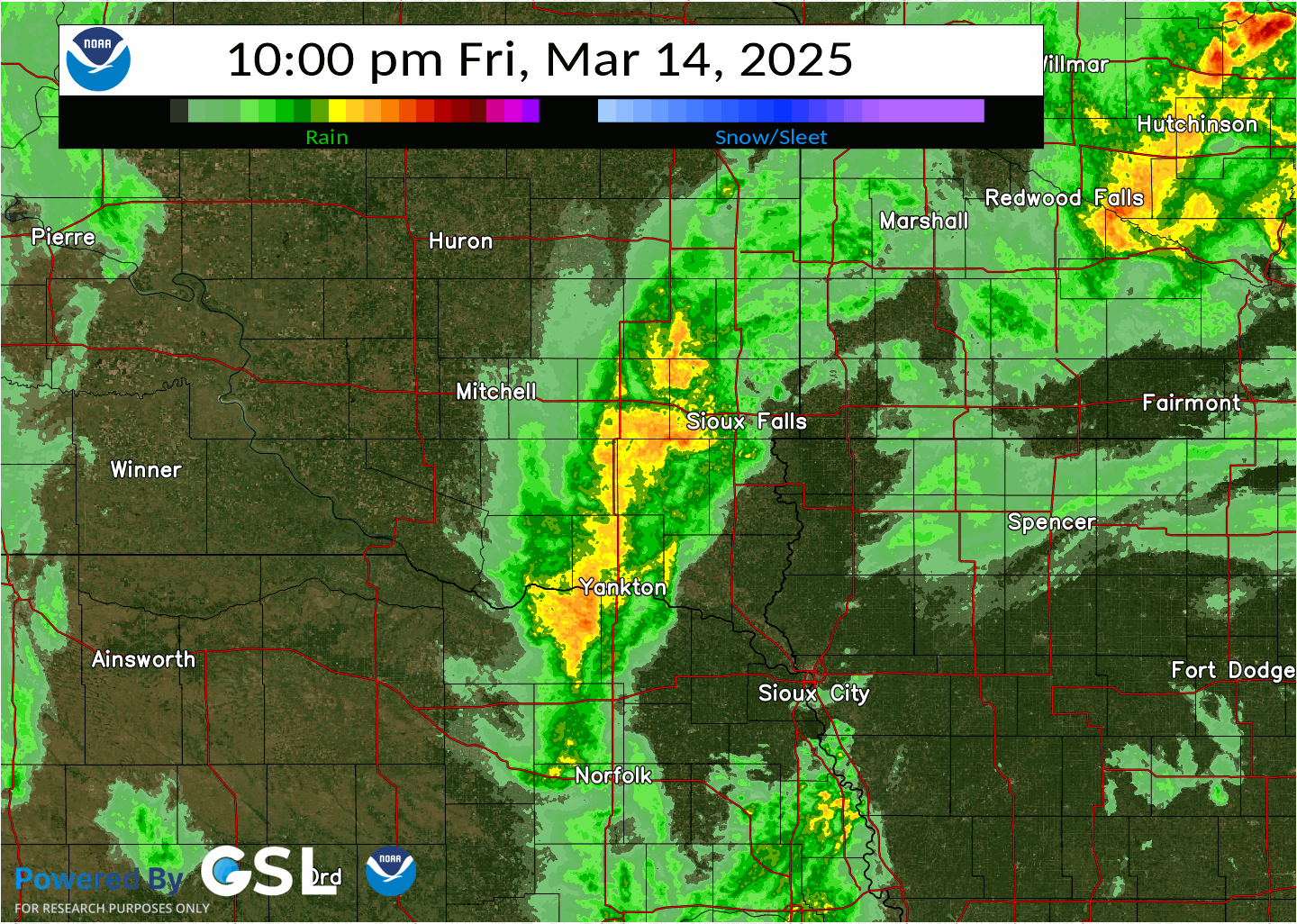 |
| Radar Loop Mar. 14 from 9 AM - 10 PM | Radar Loop from Mar. 14 10 PM to 11 AM Mar. 15 |
Storm Reports
..TIME...   ...EVENT...      ...CITY LOCATION...     ...LAT.LON...
..DATE...   ....MAG....      ..COUNTY LOCATION..ST.. ...SOURCE....
            ..REMARKS..

0705 PM     Tstm Wnd Gst     6 N Cleghorn            42.89N 95.70W
03/14/2025  M63 MPH          Cherokee           IA   Mesonet

            Via personal weather station.

0740 PM     Tstm Wnd Gst     2 WSW Gayville          42.88N 97.22W
03/14/2025  M62 MPH          Yankton            SD   Mesonet

            Mesonet station 197 SD RWIS Gayville.

0642 PM     Tstm Wnd Gst     4 E Truesdale           42.73N 95.11W
03/14/2025  M61 MPH          Buena Vista        IA   Mesonet

            Via personal weather station.

0624 PM     Tstm Wnd Gst     Arthur                  42.34N 95.34W
03/14/2025  M59 MPH          Ida                IA   Mesonet

            Via personal weather station.

0626 PM     Tstm Wnd Gst     6 SSE Galva             42.42N 95.38W
03/14/2025  M58 MPH          Ida                IA   Mesonet

            Via personal weather station.

0639 PM     Tstm Wnd Gst     3 SSE Lakeside          42.58N 95.15W
03/14/2025  M58 MPH          Buena Vista        IA   Mesonet

            Via personal weather station.

0646 PM     Tstm Wnd Gst     2 NE Truesdale          42.75N 95.15W
03/14/2025  M58 MPH          Buena Vista        IA   Mesonet

            Mesonet station RSLI4 Storm Lake.
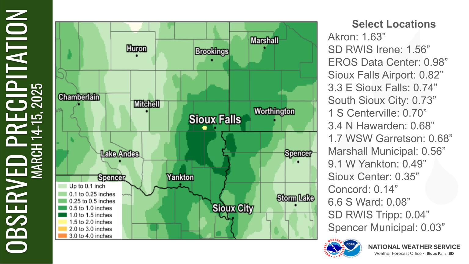
Rain Reports
The heaviest rainfall amounts with the system occurred through southeast South, extreme western Iowa, and southwestern Minnesota.
 |
Media use of NWS Web News Stories is encouraged! Please acknowledge the NWS as the source of any news information accessed from this site. |
|


 Weather Story
 Weather Map
 Local Radar