Overview
|
During the late afternoon and evening hours of Tuesday, July 15, 2025 scattered thunderstorms quickly developed across central South Dakota into eastern South Dakota. As these storms developed, brief hail was observed, along with strong wind gusts. Near the city of Chamberlain, a brief tornado touched down in the Missouri River and traveled on the western side of the river. |
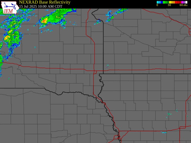 Radar Loop - July 15, 2025 |
Storm Reports
Here's a look at local storm reports from the evening of July 15th into the early overnight hours of July 16th. While there were some reports of large hail, most of the storm reports were related to strong wind gusts and associated damage as they moved through the region.
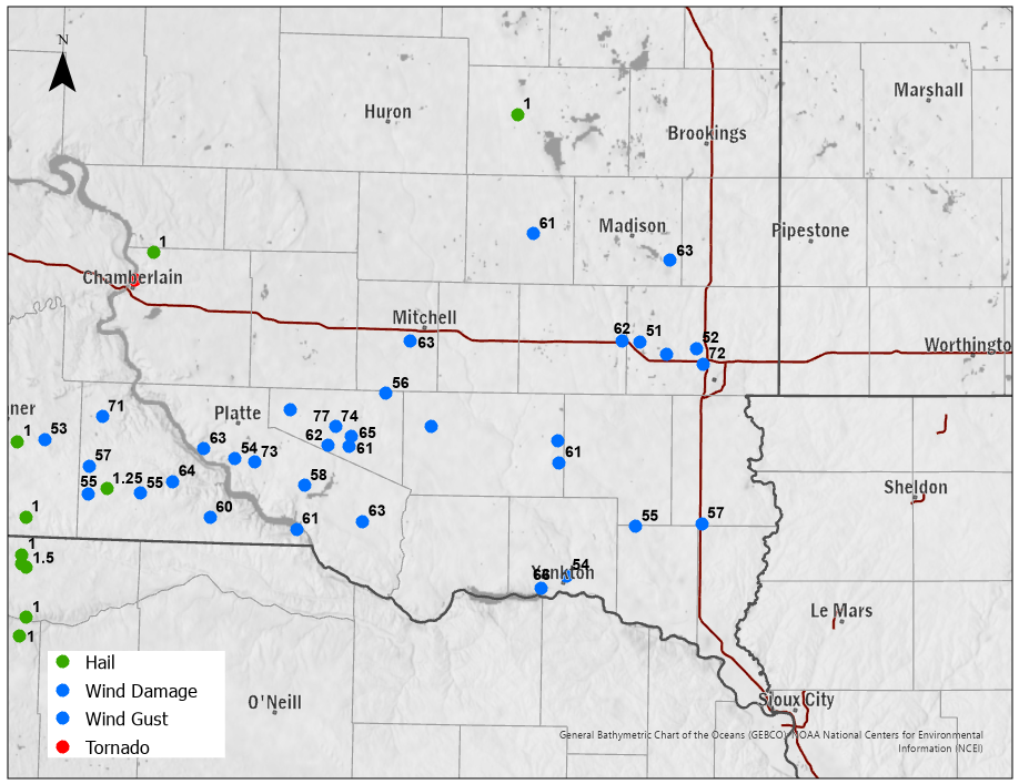 |
| Preliminary Local Storm Reports - July 15, 2025 |
Preliminary Local Storm Report...Summary National Weather Service Sioux Falls SD 1201 PM CDT Wed Jul 16 2025 ..TIME... ...EVENT... ...CITY LOCATION... ...LAT.LON... ..DATE... ....MAG.... ..COUNTY LOCATION..ST.. ...SOURCE.... ..REMARKS.. 0736 PM Tstm Wnd Gst 5 W Yankton 42.88N 97.49W 07/15/2025 M66 MPH Yankton SD Public Measured by personal weather station. First severe gust at 736 pm at 61 mph, and 66 mph at 741 pm. 0628 PM Tstm Wnd Gst 1 E Wagner 43.08N 98.28W 07/15/2025 M63 MPH Charles Mix SD Public Personal weather station. 0435 PM Hail 9 NNE Chamberlain 43.92N 99.24W 07/15/2025 E1.00 Inch Brule SD Public In addition to a few quarter sized hail stones, rainfall was about 0.30 to 0.40 inch. 0740 PM Tstm Wnd Gst 2 NNE Yankton 42.92N 97.38W 07/15/2025 M54 MPH Yankton SD AWOS 0757 PM Tstm Wnd Gst 4 E Irene 43.08N 97.08W 07/15/2025 M55 MPH Turner SD Dept of Highways Mesonet station 320 SD RWIS IRENE. 0825 PM Tstm Wnd Gst 1 N Humboldt 43.67N 97.07W 07/15/2025 M51 MPH Minnehaha SD Public Personal weather station. 0835 PM Tstm Wnd Dmg Hartford 43.63N 96.95W 07/15/2025 Minnehaha SD Trained Spotter Wind gusts estimated at 60-65 mph knocked a couple trees down. Heavy rain followed, reducing visibility to about 100 feet . 0848 PM Tstm Wnd Gst 4 S Crooks 43.60N 96.79W 07/15/2025 M72 MPH Minnehaha SD Mesonet Personal weather station. 0849 PM Tstm Wnd Gst 1 SW Crooks 43.65N 96.82W 07/15/2025 M52 MPH Minnehaha SD Public Personal weather station. 0725 PM Tstm Wnd Gst 1 W Howard 44.01N 97.55W 07/15/2025 M61 MPH Miner SD Dept of Highways Mesonet station 297 SD RWIS Howard. 0822 PM Tstm Wnd Gst 3 SE Montrose 43.67N 97.15W 07/15/2025 M62 MPH McCook SD Dept of Highways Mesonet station 18 SD RWIS Montrose. 0851 PM Tstm Wnd Gst 1 NW Beresford 43.09N 96.79W 07/15/2025 M57 MPH Lincoln SD Public Via personal weather station. 0845 PM Tstm Wnd Gst 2 NNW Chester 43.93N 96.94W 07/15/2025 M63 MPH Lake SD Public Via personal weather station. 0608 PM Hail 4 W De Smet 44.39N 97.63W 07/15/2025 E1.00 Inch Kingsbury SD Trained Spotter 0707 PM Tstm Wnd Dmg Parkston 43.39N 97.99W 07/15/2025 Hutchinson SD Emergency Mngr Strong wind gusts pushed through town, breaking many tree branches, blowing out a grain bin, and registering about 53 mph at the airport. 0738 PM Tstm Wnd Dmg Freeman 43.35N 97.43W 07/15/2025 Hutchinson SD Public Tree down blocking the road near 3rd and Cherry. Via social media. 0742 PM Tstm Wnd Gst 5 S Freeman 43.28N 97.42W 07/15/2025 M61 MPH Hutchinson SD Dept of Highways Mesonet station 163 SD RWIS Freeman. Initial severe gust at 742 pm with a peak gust of 61 mph at 744 pm. 0439 PM Tstm Wnd Gst 1 ESE Dallas 43.23N 99.49W 07/15/2025 M57 MPH Gregory SD Mesonet Mesonet station 307 SD RWIS Dallas. 0442 PM Tstm Wnd Gst 7 SSE Dallas 43.14N 99.49W 07/15/2025 M55 MPH Gregory SD Mesonet Mesonet station GGMS2 Gregory 7SSW. 0442 PM Tstm Wnd Gst 2 E Dixon 43.39N 99.44W 07/15/2025 M71 MPH Gregory SD Dept of Highways Mesonet station 283 SD RWIS Dixon. 0501 PM Hail 5 S Gregory 43.16N 99.41W 07/15/2025 E1.25 Inch Gregory SD Trained Spotter In addition to hail up to half dollar size, heavy rain and 40-50 mph wind gusts stripped some leaves from trees. 0504 PM Tstm Wnd Gst 3 SE Burke 43.15N 99.26W 07/15/2025 E55 MPH Gregory SD Public Measured by personal weather station. 0517 PM Tstm Wnd Gst 6 NNE Herrick 43.19N 99.12W 07/15/2025 M64 MPH Gregory SD Public Personal weather station. 0555 PM Tstm Wnd Gst Bonesteel 43.08N 98.95W 07/15/2025 E60 MPH Gregory SD Trained Spotter 0608 PM Tstm Wnd Gst 2 WSW Pickstown 43.05N 98.57W 07/15/2025 M61 MPH Gregory SD Dept of Highways Mesonet station 244 SD RWIS Ft. Randall Dam. 0611 PM Tstm Wnd Dmg 4 WSW Harrison 43.43N 98.61W 07/15/2025 Douglas SD Emergency Mngr Damage across town included uprooted tree, roof and siding damage from flying debris, damage to metal barn and a bent street sign. 0620 PM Tstm Wnd Gst 5 W Armour 43.32N 98.44W 07/15/2025 M62 MPH Douglas SD Public Personal weather station. 0620 PM Tstm Wnd Gst 3 S Corsica 43.38N 98.41W 07/15/2025 M74 MPH Douglas SD Dept of Highways Mesonet station 304 SD RWIS Corsica. 0625 PM Tstm Wnd Gst Armour 43.32N 98.35W 07/15/2025 E61 MPH Douglas SD Public Personal weather station. 0625 PM Tstm Wnd Gst 2 N Armour 43.35N 98.34W 07/15/2025 M65 MPH Douglas SD Public Personal weather station. 0625 PM Tstm Wnd Gst 3 S Corsica 43.38N 98.41W 07/15/2025 M77 MPH Douglas SD Mesonet Mesonet station 304 SD RWIS Corsica. 0640 PM Tstm Wnd Gst 10 W Dimock 43.49N 98.19W 07/15/2025 M56 MPH Douglas SD Public personal weather station. 0706 PM Tstm Wnd Gst 6 SSW Mitchell 43.66N 98.09W 07/15/2025 M63 MPH Davison SD Public personal weather station. 0532 PM Tstm Wnd Gst 9 SW Platte 43.30N 98.99W 07/15/2025 M63 MPH Charles Mix SD Public Personal weather station. 0535 PM Tstm Wnd Gst 7 W Geddes 43.27N 98.85W 07/15/2025 M54 MPH Charles Mix SD Public Personal weather station. 0546 PM Tstm Wnd Gst 3 W Geddes 43.26N 98.76W 07/15/2025 M73 MPH Charles Mix SD Mesonet Mesonet station RLAS2 Lake Andes RAWS. 0605 PM Tstm Wnd Gst 3 N Lake Andes 43.19N 98.54W 07/15/2025 M58 MPH Charles Mix SD Public Personal weather station. |
Rain Reports
Here's a closer look at rainfall totals across the region.
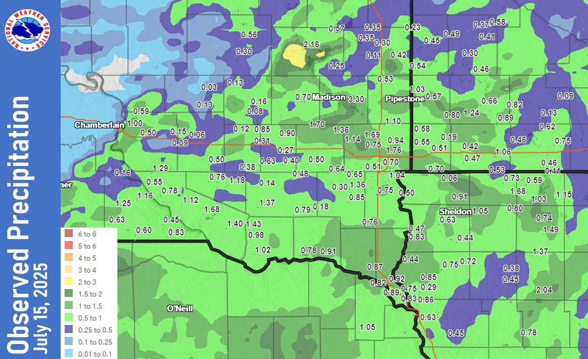 |
| Observed Precipitation - July 15, 2025 |
...PRECIPITATION REPORTS FROM JULY 15, 2025... Location Amount ...Iowa... ...Buena Vista County... Storm Lake 3.1 S 2.04 in ...Cherokee County... Cherokee 5.1 S 0.45 in Cherokee 4.5 NNW 0.39 in 0.9 NE Cherokee 0.38 in ...Clay County... Spencer Municipal Airport 2.32 in Spencer 7.0 S 1.49 in ...Dickinson County... Milford 1.4 NNE 1.51 in Spirit Lake 1.37 in Milford 1.0 SSE 1.34 in TERRIL 1.15 in Wahpeton 1.07 in Milford 1.03 in 0.6 E Spirit Lake 0.98 in Lake Park 0.2 N 0.89 in Lake Park 0.63 in Lake Park 3.2 SSE 0.59 in 2.1 NW Orleans 0.41 in ...Ida County... Arthur 3.7 SSW 0.78 in ...Lyon County... 5 SSW Ellsworth 1.65 in 4 SW George 0.91 in Larchwood 1.2 NNE 0.72 in Rock Rapids 7.7 WNW 0.70 in ...OBrien County... Sheldon 1.05 in Hartley 0.80 in ...Osceola County... MAY CITY 1.68 in Ocheyedan 0.73 in Sibley 6.1 NNE 0.53 in ...Plymouth County... 6 NNE Jefferson 1.11 in Loess Hills Tnc Broken 0.99 in 6.2 NW Hinton 0.85 in Le Mars 0.9 SE 0.83 in Le Mars 1.0 E 0.75 in Remsen 0.72 in Big Sioux River 0.44 in 4.0 W Hinton 0.29 in ...Sioux County... Hawarden 0.83 in Ireton 5.5 N 0.78 in Sioux Center 0.73 in Orange City 0.4 NNE 0.72 in Orange City 0.4 WNW 0.66 in Orange City 0.66 in Sioux Center 2.6 N 0.63 in Floyd River 0.44 in ...Woodbury County... SIOUX CITY 0.86 in 1 ENE Dakota City 0.83 in Sioux Gateway Airport 0.66 in 1.2 N Sioux City 0.65 in Sioux City 0.63 in 3.4 N Hornick 0.45 in ...Minnesota... ...Cottonwood County... 2.6 NW Windom 0.13 in PRINSBURG 0.10 in ...Jackson County... Lakefield 1.06 in Lakefield 0.9 NNE 1.03 in Jackson 4.6 NNW 0.75 in Jackson 7.8 SW 0.72 in Lakefield 7.8 N 0.62 in 6 NW Orleans 0.46 in ...Lincoln County... Pipestone 14.3 N 0.69 in Ivanhoe 5.7 E 0.49 in Hendricks 8.0 SE 0.45 in ...Lyon County... 4 S Cottonwood 0.58 in Marshall 0.48 in Balaton 2.1 SE 0.46 in Marshall 3.7 W 0.44 in Marshall Municipal Airport 0.41 in Marshall 0.41 in Ghent 0.2 NNE 0.40 in Ghent 2.8 ENE 0.37 in Russell 0.30 in ...Murray County... Chandler 2.8 WNW 1.90 in Chandler 2.7 SSE 1.24 in Fulda 0.9 SSE 0.89 in 7.5 S Dovray 0.82 in Slayton Municipal Airport 0.66 in Slayton 0.8 SSW 0.66 in ...Nobles County... Worthington 2 NNE 1.25 in Worthington Airport 1.11 in Worthington 1.9 SW 1.06 in Bigelow 1.8 NW 0.68 in Adrian 4.8 S 0.47 in Brewster 0.1 SW 0.46 in Adrian 1.5 NW 0.42 in Worthington 4.0 S 0.30 in ...Pipestone County... Pipestone 1.73 in Redstone RAWS 1.37 in Edgerton 0.2 WSW 0.80 in 6.0 NW Ihlen 0.61 in 2.1 N Pipestone 0.57 in ...Rock County... Hills 0.2 NW 1.11 in 2.3 NE Sherman 0.58 in Beaver Creek 5.8 NW 0.55 in Luverne 0.51 in ...Nebraska... ...Dakota County... South Sioux City 0.72 in ...Dixon County... Concord 4.23 S 1.05 in 1 WNW Ponca 0.89 in Newcastle 0.82 in ...South Dakota... ...Aurora County... Stickney 3.8 SW 0.50 in Plankinton 3.8 W 0.13 in White Lake (SD Mesonet) 0.06 in ...Beadle County... Huron 6.8 NNE 0.56 in Huron Regional Airport 0.31 in Huron 1.8 S 0.30 in Huron 2.0 S 0.30 in ...Bon Homme County... Springfield 7.6 WNW 1.02 in Avon 2.1 W 0.98 in ...Brookings County... Aurora 0.3 NE 1.74 in Aurora 0.3 NNE 1.57 in Aurora 7.5 N 1.27 in Elkton 0.55 in Astoria 2.2 SSE 0.55 in Elkton 0.54 in Brookings 2 NE 0.44 in Brookings 2.8 SSW 0.43 in Aurora 2NNE 0.42 in Toronto 3.9 SW 0.39 in Brookings 1.6 S 0.38 in Brookings 0.3 E 0.38 in Brookings 0.2 SSW 0.38 in Bruce 5.3 W 0.35 in Bruce 5.2 NNW 0.35 in Brookings 1.4 SW 0.31 in Brookings 5.3 N 0.31 in Brookings 6.5 NNW 0.30 in Volga 0.1 S 0.28 in Astoria 4 SSE (SD Mesonet) 0.23 in Brookings Municipal Airport 0.16 in Brookings 2NE 0.15 in ...Brule County... Chamberlain 0.3 W 1.14 in Chamberlain 0.6 N 1.00 in Chamberlain 0.5 W 0.73 in Chamberlain 7.5 NNE 0.59 in Pukwana 1.9 S 0.50 in SD RWIS Kimball 0.26 in Kimball 3.9 ENE 0.15 in Kimball 6.7 SE 0.09 in ...Charles Mix County... Lake Andes 2.4 N 1.68 in SD RWIS WAGNER 1.43 in Wagner 0.8 NW 1.40 in Platte 1.37 in Academy 2 NE 1.29 in Lake Andes RAWS 1.12 in Dante 3.1 S 1.01 in 7.6 SW Platte 0.78 in ...Clay County... Vermillion 1.4 SE 0.87 in ...Davison County... Mitchell Municipal Airport 0.85 in Ethan 0.63 in Mitchell 1.0 SE 0.58 in Mitchell 7.3 S 0.57 in Ethan 4.5 WSW 0.52 in ...Douglas County... SD RWIS Corsica 1.96 in Armour 6.3 NNE 1.18 in Corsica 0.1 SSE 0.95 in Corsica 4.3 W 0.76 in Dimock 10.2 W 0.38 in ...Gregory County... Gregory 1.25 in Herrick 8.2 SSW 1.16 in Burke 8.6 NNE 1.16 in Butte 8NNW 0.83 in Dallas 8.8 S 0.63 in Burke 10.5 SSE 0.60 in Bonesteel 0.1 S 0.52 in 2 N Bonesteel 0.45 in SD RWIS Dixon 0.39 in SD RWIS Dallas 0.39 in Gregory 7SSW 0.35 in Burke 6.7 S 0.24 in ...Hanson County... SD RWIS Alexandria 1.46 in Spencer 5.6 NW 1.30 in Alexandria 6.4 N 0.90 in Alexandria 7.5 SSE 0.40 in Alexandria 3.4 SE 0.30 in Alexandria 2.6 SSW 0.27 in ...Hutchinson County... SD RWIS Tripp 1.37 in Parkston 6.5 WSW 0.73 in Emery 10.8 S 0.48 in Menno 7ESE 0.18 in Parkston (SD Mesonet) 0.14 in ...Jerauld County... SD RWIS Lane 0.46 in Wessington Springs 9.3 SSW 0.13 in ...Kingsbury County... De Smet 0.2 SSE 2.16 in Lake Preston 10.5 NNE 0.57 in SD RWIS Arlington 0.52 in Oldham 0.9 E 0.25 in ...Lake County... Madison 2SE 3.30 in Wentworth 4.7 SSW 1.83 in Madison 6S 0.53 in ...Lincoln County... Harrisburg 1.1 WSW 1.20 in HARRISBURG 1.07 in Harrisburg 0.8 NNE 1.07 in Harrisburg 0.7 NNE 1.04 in Sioux Falls 4.0 SSE 0.98 in Lennox 3.3 NE 0.87 in Tea 1.1 NNW 0.87 in Sioux Falls 4.5 SSW 0.81 in Sioux Falls 4.2 S 0.79 in Sioux Falls 3.6 S 0.78 in Worthing 2.0 W 0.75 in Sioux Falls 3.6 SSE 0.72 in Canton 0.50 in ...McCook County... Canova 1.70 in Salem 5NE 1.43 in Montrose 5.8 NW 1.36 in SD RWIS Montrose 1.25 in Montrose 3.1 SW 1.18 in SD RWIS STANLEY CORNER 1.15 in Montrose 2.4 E 1.14 in Parker 7.2 N 0.79 in Parker 9.7 N 0.79 in Bridgewater 0.50 in ...Miner County... SD RWIS Howard 1.69 in Howard 0.90 in Howard 0.7 SSW 0.90 in Howard 5.3 W 0.70 in ...Minnehaha County... Crooks 0.7 WSW 2.56 in Crooks 0.2 S 2.20 in Sioux Falls 5.5 N 1.76 in EROS DATA CNTR SIOUX FALLS 1 1.74 in Colton 3.8 S 1.69 in SIOUX FALLS 1.50 in Montrose 3.7 E 1.50 in Hartford 0.7 ENE 1.34 in Renner 4.1 NW 1.17 in Dell Rapids 7.6 W 1.14 in Sioux Falls 5.1 ENE 1.10 in Hartford 0.5 N 1.10 in Dell Rapids 0.9 WNW 1.10 in 4 ESE Sioux Falls 1.09 in Sioux Falls 3.6 ESE 1.09 in Sioux Falls 3.4 ESE 1.09 in Sioux Falls 3.3 E 1.08 in Sioux Falls 2.6 ESE 1.07 in Sioux Falls 3.3 E 1.02 in 5 W Garretson 1.01 in Sioux Falls Airport 0.98 in Sioux Falls 0.95 in Sioux Falls 3.3 E 0.95 in Sioux Falls 5.2 E 0.95 in 5 SSE Baltic 0.94 in Sioux Falls 0.94 in Sioux Falls 5.0 SE ARPT 0.94 in SIOUX FALLS 0.93 in Sioux Falls 4.0 SE 0.91 in Sioux Falls 3.7 NW 0.90 in Sioux Falls 4.9 WSW 0.88 in Sioux Falls 4.2 WSW 0.88 in Sioux Falls 3.3 W 0.85 in Sioux Falls 3.7 WSW 0.85 in Sioux Falls 3.0 S 0.84 in Sioux Falls 1.9 SSW 0.84 in Garretson 1.7 WSW 0.83 in Sioux Falls 4.9 ESE 0.82 in Sioux Falls 4.1 WSW 0.82 in Sioux Falls 1.6 SW 0.78 in 2.7 NE Hartford 0.75 in Garretson 4.2 SSE 0.74 in Sioux Falls 3.0 S 0.73 in Sioux Falls 1.2 WSW 0.70 in ...Moody County... SD RWIS Ward 2.19 in Flandreau 2.05 in Brookings 8.1 S 0.69 in Colman 10.6 N 0.53 in ...Sanborn County... SD RWIS Forestburg 0.81 in Woonsocket 0.2 WSW 0.68 in 3.8 SE Forestburg 0.26 in Letcher 0.5 E 0.23 in Woonsocket 4NNW 0.13 in ...Turner County... SD RWIS IRENE 2.03 in SD RWIS Parker 1.36 in Hurley 0.2 S 0.85 in Marion 0.81 in 1 S Centerville 0.76 in Marion 4.8 NNW 0.64 in Parker 6.8 WSW 0.30 in Parker 7NNE 0.23 in ...Union County... SD RWIS North Sioux City 1.92 in Elk Point 0.3 WSW 0.92 in Jefferson 1.1 E 0.86 in 1 WNW Jefferson 0.84 in Jefferson 4.9 S 0.83 in Jefferson 2.1 WNW 0.82 in Jefferson 2.9 SW 0.78 in Jefferson 0.75 in ...Yankton County... Mission Hill 0.1 NNW 1.15 in Yankton Municipal Airport 1.02 in Yankton 0.3 ENE 0.93 in Yankton 1.0 ESE 0.91 in Yankton 4.1 SW 0.80 in Yankton 9.1 W 0.78 in Observations are collected from a variety of sources with varying equipment and exposures. We thank all volunteer weather observers for their dedication. Not all data listed are considered official. |
 |
Media use of NWS Web News Stories is encouraged! Please acknowledge the NWS as the source of any news information accessed from this site. |
|


 Weather Story
 Weather Map
 Local Radar