Overview
|
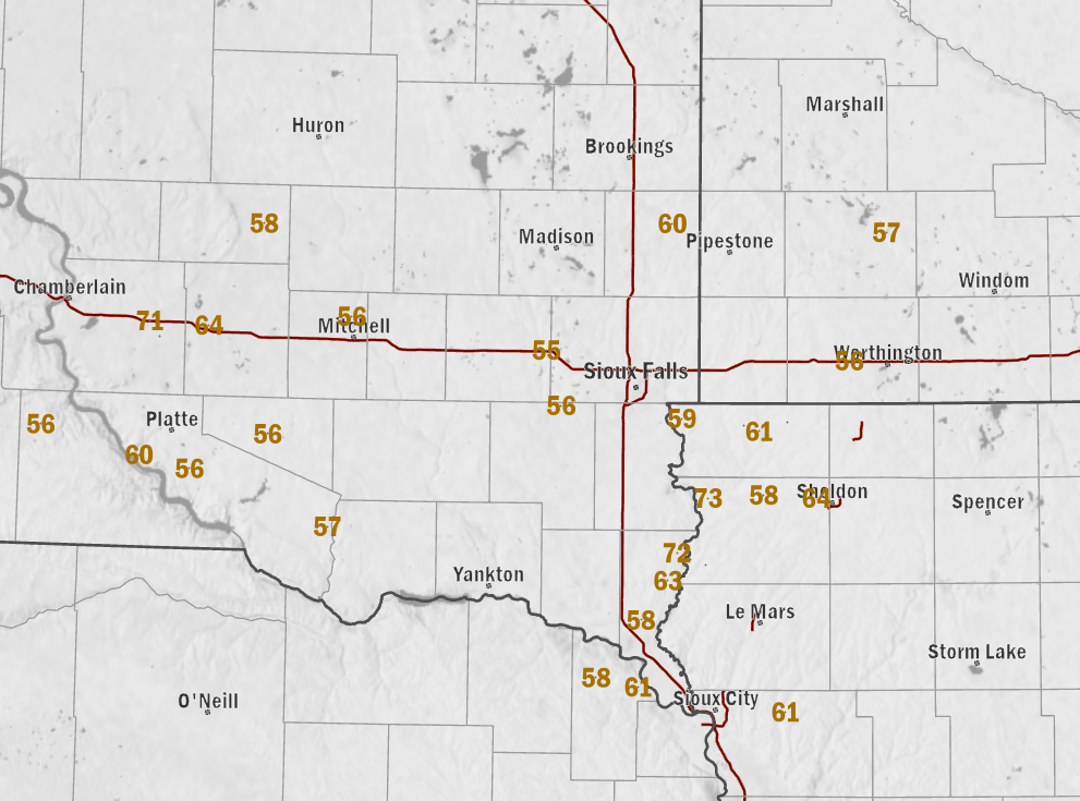
Two separate wake low events occurred within the span of 24 to 36 hours, bringing widespread 50 to 70+ mph wind gusts and associated tree and roof damage. |
Wind
 |
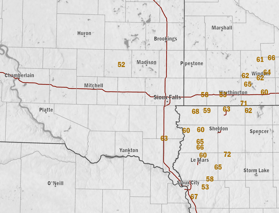 |
| Peak Wind Gusts (mph) From First Wake Low - Morning of May 19th | Peak Wind Gusts (mph) from Second Wake Low - Evening of May 19th |
-------------------------- FIRST WAKE LOW --------------------------------------------------
..TIME...   ...EVENT...      ...CITY LOCATION...     ...LAT.LON...
..DATE...   ....MAG....      ..COUNTY LOCATION..ST.. ...SOURCE....
            ..REMARKS..

0526 AM     Non-Tstm Wnd Gst 8 N Elk Point           42.79N 96.71W
05/19/2025  M58 MPH          Union              SD   Public

            Via personal weather station.

0544 AM     Non-Tstm Wnd Gst 8 SSE Alcester          42.92N 96.59W
05/19/2025  M63 MPH          Union              SD   Public

            Via personal weather station.

0553 AM     Non-Tstm Wnd Gst 7 SE Alcester           42.97N 96.52W
05/19/2025  M62 MPH          Union              SD   Public

            Via personal weather station.

0606 AM     Non-Tstm Wnd Gst 4 E Alcester            43.01N 96.55W
05/19/2025  M72 MPH          Union              SD   Public

            Via personal weather station.

0530 AM     Non-Tstm Wnd Gst 7 WSW Wall Lake         43.49N 97.08W
05/19/2025  M56 MPH          Turner             SD   Mesonet

            Mesonet station PKMS2 Parker 7NNE.

0630 AM     Non-Tstm Wnd Gst 3 NNE Flandreau         44.09N 96.58W
05/19/2025  M60 MPH          Moody              SD   Mesonet

            Mesonet station FLNS2 Flandreau 3 NNE (SD
            Mesonet).

0542 AM     Non-Tstm Wnd Gst 3 SE Montrose           43.67N 97.15W
05/19/2025  M55 MPH          McCook             SD   Mesonet

            Mesonet station 18 SD RWIS Montrose.

0526 AM     Non-Tstm Wnd Gst 1 W Lane                44.07N 98.45W
05/19/2025  M58 MPH          Jerauld            SD   Mesonet

            Mesonet station 305 SD RWIS Lane.

0329 AM     Non-Tstm Wnd Gst 2 E Dixon               43.39N 99.44W
05/19/2025  M56 MPH          Gregory            SD   Mesonet

            Mesonet station 283 SD RWIS Dixon.

0437 AM     Non-Tstm Wnd Gst 3 S Corsica             43.38N 98.41W
05/19/2025  M56 MPH          Douglas            SD   Mesonet

            Mesonet station 304 SD RWIS Corsica.

0509 AM     Non-Tstm Wnd Gst 3 N Mitchell            43.77N 98.04W
05/19/2025  M56 MPH          Davison            SD   ASOS

            ASOS station KMHE Mitchell Municipal
            Airport.

0417 AM     Non-Tstm Wnd Gst 4 NE Dante              43.08N 98.13W
05/19/2025  M57 MPH          Charles Mix        SD   Mesonet

            Mesonet station 324 SD RWIS WAGNER.

0441 AM     Non-Tstm Wnd Gst 3 W Geddes              43.26N 98.76W
05/19/2025  M56 MPH          Charles Mix        SD   Mesonet

            Mesonet station RLAS2 Lake Andes RAWS.

0445 AM     Non-Tstm Wnd Gst 9 SW Platte             43.30N 98.99W
05/19/2025  M60 MPH          Charles Mix        SD   Public

            Via personal weather station.

0414 AM     Non-Tstm Wnd Gst 1 S Kimball             43.74N 98.96W
05/19/2025  M71 MPH          Brule              SD   Mesonet

            Mesonet station 25 SD RWIS Kimball.

0425 AM     Non-Tstm Wnd Gst 4 SSE Kimball           43.69N 98.91W
05/19/2025  E58 MPH          Brule              SD   Public

            Via personal weather station.

0430 AM     Non-Tstm Wnd Gst 1 ENE White Lake        43.73N 98.69W
05/19/2025  M64 MPH          Aurora             SD   Mesonet

            Mesonet station WTES2 White Lake (SD
            Mesonet).

0508 AM     Non-Tstm Wnd Gst 4 SSW Newcastle         42.60N 96.91W
05/19/2025  M58 MPH          Dixon              NE   Public

            Via personal weather station.

0611 AM     Non-Tstm Wnd Gst Ponca                   42.57N 96.72W
05/19/2025  M61 MPH          Dixon              NE   Public

            Via personal weather station.

0612 AM     Non-Tstm Wnd Gst 2 NW Ponca              42.59N 96.75W
05/19/2025  M60 MPH          Dixon              NE   Public

            Via personal weather station.

0755 AM     Non-Tstm Wnd Gst 2 NE Rushmore           43.64N 95.77W
05/19/2025  M56 MPH          Nobles             MN   Mesonet

            Mesonet station MN007 I-90 - Rushmore - Mp
            35.

0815 AM     Non-Tstm Wnd Gst 3 W Dovray              44.06N 95.60W
05/19/2025  M57 MPH          Murray             MN   Mesonet

            Mesonet station MN038 T.h.30 - Dovray - Mp
            49.

0744 AM     Non-Tstm Wnd Gst Moville                 42.49N 96.06W
05/19/2025  M61 MPH          Woodbury           IA   Public

            Via personal weather station.

0505 AM     Non-Tstm Wnd Gst 4 W Sheldon             43.19N 95.92W
05/19/2025  M64 MPH          Sioux              IA   Public

            Via personal weather station.

0610 AM     Non-Tstm Wnd Gst 1 SSW Hawarden          42.99N 96.49W
05/19/2025  M57 MPH          Sioux              IA   Mesonet

            Mesonet station FW6302 Hawarden.

0610 AM     Non-Tstm Wnd Dmg Hawarden                43.00N 96.48W
05/19/2025                   Sioux              IA   Emergency Mngr

            Tree damage across town as well as tin
            peeled off of local business.

0625 AM     Non-Tstm Wnd Gst 6 W Rock Valley         43.19N 96.41W
05/19/2025  E73 MPH          Sioux              IA   Public

            Via personal weather station.

0630 AM     Non-Tstm Wnd Gst 4 SE Hawarden           42.97N 96.42W
05/19/2025  M64 MPH          Sioux              IA   Public

            Via personal weather station.

0635 AM     Non-Tstm Wnd Dmg Rock Valley             43.20N 96.30W
05/19/2025                   Sioux              IA   Trained Spotter

            Pictures via trained spotter as well as
            social media of tree damage across town.
            Time estimated.

0710 AM     Non-Tstm Wnd Gst 2 WNW Hull              43.20N 96.16W
05/19/2025  M58 MPH          Sioux              IA   Public

            Via personal weather station.

0546 AM     Non-Tstm Wnd Dmg Akron                   42.83N 96.56W
05/19/2025                   Plymouth           IA   Public

            Picture via social media of tree damage
            across town.

0640 AM     Non-Tstm Wnd Dmg Remsen                  42.81N 95.97W
05/19/2025                   Plymouth           IA   Broadcast Media

            Picture of large tree down. Time estimated.

0633 AM     Non-Tstm Wnd Gst 5 W Larchwood           43.45N 96.53W
05/19/2025  M59 MPH          Lyon               IA   Public

            Via personal weather station.

0643 AM     Non-Tstm Wnd Dmg Rock Rapids             43.43N 96.17W
05/19/2025                   Lyon               IA   Emergency Mngr

            Approximately 3 to 4 dozen trees down across
            town. Time estimated.

0643 AM     Non-Tstm Wnd Gst 1 SSW Rock Rapids       43.41N 96.18W
05/19/2025  M61 MPH          Lyon               IA   Public

            Via personal weather station.

0647 AM     Non-Tstm Wnd Gst 4 E Lester              43.43N 96.25W
05/19/2025  M72 MPH          Lyon               IA   Public

            Via personal weather station.

0730 AM     Non-Tstm Wnd Gst 6 E Rock Rapids         43.44N 96.05W
05/19/2025  M63 MPH          Lyon               IA   Public

            Via personal weather station.
--------------------SECOND WAKE LOW ---------------------------------------------------------
1055 PM     Non-Tstm Wnd Gst 6 N Cleghorn            42.89N 95.70W
05/19/2025  M72 MPH          Cherokee           IA   Public

            Report via personal weather station.

1028 PM     Non-Tstm Wnd Gst 3 ESE Round Lake        43.53N 95.41W
05/19/2025  M71 MPH          Jackson            MN   Public

            Report via personal weather station.

0821 PM     Non-Tstm Wnd Gst 4 E Lester              43.43N 96.25W
05/19/2025  M68 MPH          Lyon               IA   Public

            Report via personal weather station.

0756 PM     Non-Tstm Wnd Gst 3 N Salix               42.36N 96.27W
05/19/2025  M67 MPH          Woodbury           IA   Public

            Report via personal weather station.

1100 PM     Non-Tstm Wnd Gst 11 N Mountain Lake      44.10N 94.92W
05/19/2025  M66 MPH          Cottonwood         MN   Public

            Report via personal weather station.

0945 PM     Non-Tstm Wnd Gst 2 S Sioux Center        43.05N 96.17W
05/19/2025  M65 MPH          Sioux              IA   Public

            Report via personal weather station.

1112 PM     Non-Tstm Wnd Gst 2 SSW Heron Lake        43.77N 95.34W
05/19/2025  M65 MPH          Jackson            MN   Public

            Report via personal weather station.

1200 AM     Non-Tstm Wnd Gst 7 SSW Marcus            42.73N 95.86W
05/20/2025  M65 MPH          Plymouth           IA   Public

            Report via personal weather station.

1100 PM     Non-Tstm Wnd Gst 2 ENE Bingham Lake      43.92N 95.00W
05/19/2025  M64 MPH          Cottonwood         MN   Mesonet

            Mesonet station MN150 T.h.60 - Mountain Lake
            - Mp 48.

0655 PM     Non-Tstm Wnd Gst 1 NW Beresford          43.09N 96.79W
05/19/2025  M63 MPH          Lincoln            SD   Public

            Report via personal weather station.

1034 PM     Non-Tstm Wnd Gst Lake Park               43.44N 95.33W
05/19/2025  M62 MPH          Dickinson          IA   Public

            Report via personal weather station.

1055 PM     Non-Tstm Wnd Gst 2 S Windom              43.85N 95.12W
05/19/2025  M62 MPH          Jackson            MN   Public

            Report via personal weather station.

1151 PM     Non-Tstm Wnd Gst 5 ENE Dundee            43.88N 95.38W
05/19/2025  M62 MPH          Cottonwood         MN   Public

            Report via personal weather station.

1150 PM     Non-Tstm Wnd Gst 4 ENE Jeffers           44.08N 95.12W
05/19/2025  M61 MPH          Cottonwood         MN   Mesonet

            Mesonet station MN071 T.h.71 - Jeffers - Mp
            43.

0830 PM     Non-Tstm Wnd Gst 4 ESE Struble           42.88N 96.12W
05/19/2025  M60 MPH          Plymouth           IA   Public

            Report via personal weather station.

1018 PM     Non-Tstm Wnd Gst 5 NW Jackson            43.67N 95.05W
05/19/2025  M60 MPH          Jackson            MN   Public

            Report via personal weather station.

1020 PM     Non-Tstm Wnd Gst 2 S Mountain Lake       43.91N 94.92W
05/19/2025  M60 MPH          Cottonwood         MN   Public

            Report via personal weather station.

0631 PM     Non-Tstm Wnd Gst 3 SSW Beresford         43.04N 96.80W
05/19/2025  M59 MPH          Union              SD   Mesonet

            Mesonet station 16 SD RWIS Beresford.

0756 PM     Non-Tstm Wnd Gst 2 NE Rock Rapids        43.45N 96.13W
05/19/2025  M59 MPH          Lyon               IA   Public

            Report via personal weather station.

0819 PM     Non-Tstm Wnd Gst 6 W Rock Valley         43.19N 96.41W
05/19/2025  M59 MPH          Sioux              IA   Public

            Report via personal weather station.

1115 PM     Non-Tstm Wnd Gst 2 NNE Windom            43.90N 95.10W
05/19/2025  M58 MPH          Cottonwood         MN   AWOS

            AWOS station KMWM Windom Municipal Airport.

0800 PM     Non-Tstm Wnd Dmg 1 NE Sergeant Bluff     42.41N 96.35W
05/19/2025                   Woodbury           IA   Emergency Mngr

            4 foot diameter tree fell on a house. Time
            estimated.

0800 PM     Non-Tstm Wnd Dmg 3 E Salix               42.31N 96.22W
05/19/2025                   Woodbury           IA   Emergency Mngr

            Power lines down. Time estimated.

0800 PM     Non-Tstm Wnd Dmg 1 ESE Sergeant Bluff    42.39N 96.34W
05/19/2025                   Woodbury           IA   Emergency Mngr

            2 foot diameter tree fell into swimming
            pool.

0801 PM     Non-Tstm Wnd Dmg 2 WSW Bronson           42.40N 96.26W
05/19/2025                   Woodbury           IA   Emergency Mngr

            1 mile of power lines down from snapped
            poles, outbuildings damaged,, and roofs
            damaged. Time is estimated.

0802 PM     Non-Tstm Wnd Dmg 5 W Lawton              42.48N 96.28W
05/19/2025                   Woodbury           IA   Emergency Mngr

            Power lines down. Time estimated.

0802 PM     Non-Tstm Wnd Dmg 4 E Sioux City          42.50N 96.31W
05/19/2025                   Woodbury           IA   Emergency Mngr

            Outbuilding destroyed. Time estimated.
Photos & Video
Header
| Caption (source) |
Caption (source) |
Caption (source) |
Caption (source) |
What is a Wake Low?
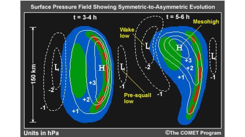
What is a wake low? As you can see in the picture above (courtesy of the Cooperative Program for Operational Meteorology, Education and Training (COMET)), it is a small area of low pressure that forms 30 to 50 miles (50 to 100 km) behind a line of showers or thunderstorms. Right behind the line of thunderstorms is a feature called a meso high. The mesohigh is the result of cold air being produced by evaporation of rain within the thunderstorms. The strength of the mesohigh is typically determined by how cold the air is behind the line of thunderstorms. Behind the mesohigh is the wake low. The presence of the wake low results in a large pressure gradient between the line of thunderstorms and the wake low. As a result, air will accelerate toward the wake from the storm, producing strong easterly winds which reach their peak as the pressure reaches its lowest values.
 |
Media use of NWS Web News Stories is encouraged! Please acknowledge the NWS as the source of any news information accessed from this site. |
|


 Weather Story
 Weather Map
 Local Radar