Numerous severe thunderstorms are expected across a broad region from the Ohio Valley to the Mid-Atlantic and Northeast States today into tonight. Swaths of damaging wind gusts are expected and some tornadoes are possible. Bertha is expected to bring tropical storm conditions to portions of the Gulf Coast from the Florida Panhandle westward to southeastern Louisiana later today and Wednesday. Read More >
Fort Worth/Dallas, TX
Weather Forecast Office
|
|
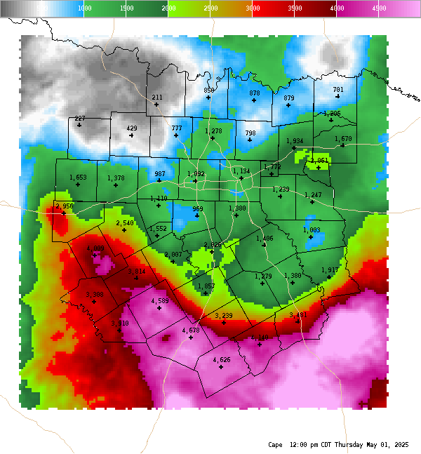
4 Panel Display | Animated Loop CAPE This is a surface based Convective Available Potential Energy (CAPE) measurement only. In the cool season, elevated instability may be much higher than surface based cape. On average, CAPE of 1000 J/Kg is usually sufficient for strong to severe storms. CAPE of 3,000 to 4,000 J/Kg or higher is usually a signal of a very volatile atmosphere that could produce severe storms if other environmental parameters are in place. Back to Convective Parameters Home
|
Current Hazards
National Outlooks
Tropical
Local Storm Reports
Storm Reports (Graphical)
Submit Storm Report
Tornado Warnings
Severe Thunderstorm Warnings
Flash Flood Warnings
Forecasts
Forecast Discussion
Graphical Forecast
Aviation Forecasts
Fire Weather
Hazard Planner
N. Texas Convective Parameters
US Dept of Commerce
National Oceanic and Atmospheric Administration
National Weather Service
Fort Worth/Dallas, TX
3401 Northern Cross Blvd.
Fort Worth, TX 76137
817.429.2631
Comments? Questions? Please Contact Us.