Dangerous heat will expand from the Gulf Coast into the Southern Plains and Desert Southwest through week's end. Additional extreme heat impacting the Pacific Northwest will shift to the northern Plains by the weekend. Tropical Storm Bertha is expected to continue to impact portions of the northwestern Gulf Coast from south central Louisiana to the upper Texas coast today. Read More >
Fort Worth/Dallas, TX
Weather Forecast Office
|
|
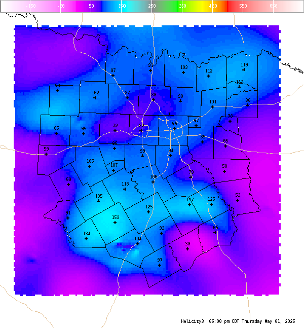
4 Panel Display | Animated Loop Helicity (0-3 Km) This is the 0-3 km (0-10,000 Ft. AGL) storm relative helicity which is a measure of the amount of wind shear available from the ground to roughly 700 MB. Values greater than 250 m**2/s**2 suggest an increased threat of tornadoes, but high values with this index do not necessarily suggest that the environment is supportive of supercell structures (look at 0-6 km shear). Larger values are generally better, but there are no clear "boundaries" between non-tornadic and significant tornadic supercells. Negative values suggest that anti-cylonic (left moving) supercells will dominate. |
Current Hazards
National Outlooks
Tropical
Local Storm Reports
Storm Reports (Graphical)
Submit Storm Report
Tornado Warnings
Severe Thunderstorm Warnings
Flash Flood Warnings
Forecasts
Forecast Discussion
Graphical Forecast
Aviation Forecasts
Fire Weather
Hazard Planner
N. Texas Convective Parameters
US Dept of Commerce
National Oceanic and Atmospheric Administration
National Weather Service
Fort Worth/Dallas, TX
3401 Northern Cross Blvd.
Fort Worth, TX 76137
817.429.2631
Comments? Questions? Please Contact Us.