A significant heat wave is underway for the Intermountain West, Northern Plains, and Upper Great Lakes, peaking in intensity through midweek and lingering across parts of the Northern Plains and Midwest until this weekend. In southwest Texas, excessive rainfall may bring a risk for potentially life-threatening flash and arroyo flooding through Thursday. Read More >
El Niño/La Niña Information

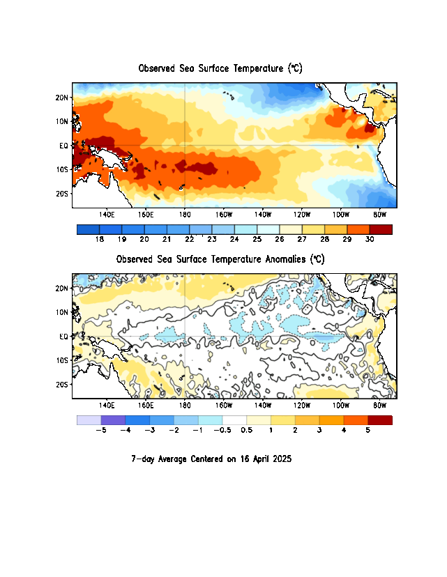
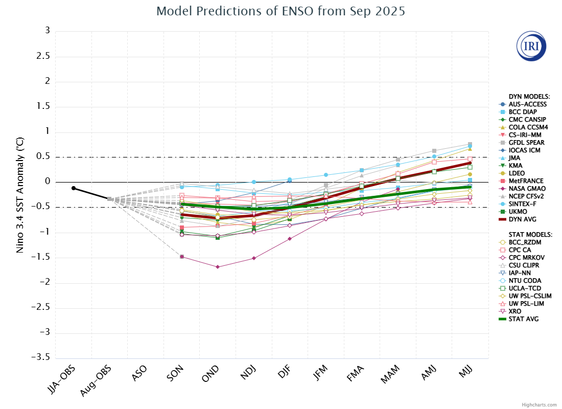
El Nino is all but certain through the end of the year and into next year as very warm ocean waters continue to build across the Equatorial Pacific. Current sea-surface temperature anomalies are running between 0 and 1 degree Celsius above average, with the exception of right along the coast of South America where it ranges from 1-2°C above normal. SST is expected to increase throughout the year as well above normal water temperatures below the surface migrates upwards across the eastern Equatorial Pacific.

The Climate Prediction Center is currently forecasting a moderate to strong El Nino by the end of the year, with a 55% chance of occurring. There is a 37% chance that the El Nino will become very strong with SST anomalies averaging >2°C.

Temperatures across the region will potentially be near or slightly below average for a given 3 month period this summer. This summer signal in ENSO isn’t guaranteed, as only about half of ENSO analog years exhibit this pattern. This signal is a lot less certain going into the fall when other global oscillations tend to have a much stronger impact on our weather here in North and Central Texas. This will have to be taken into account when considering other oscillations for the general expectation we have going forward this summer. However, with a strong or very strong El Nino likely heading into the winter, there is a historically significant trend to see cooler than normal temperatures, particularly the second half of the winter into the early Spring.
Precipitation anomalies are slightly more predictable during ENSO years here in North and Central Texas with a strong preference (70-90% chance) for above normal precipitation in the Spring giving way to drier than normal conditions during the summer months (particularly the second half of the summer). Once we get into the Fall, there is somewhat of a preference (50-60% chance) to see above normal precipitation. This signal weakens going into the winter, again with other aspects of the global circulation dictating precipitation anomalies in our part of the country during this time.
The MJO has now moved into Phase 7 as of 5/28, which is defined as negative OLR (Outgoing Longwave Radiation) anomalies across eastern portions of the West Pacific. This has manifested itself as negative OLR anomalies (increased convection) across much of the Equatorial Pacific and an eastward shift in a stronger than normal sub-tropical jet stream during the month of May.


Through the first half of June, the MJO will remain in either Phase 7 or 8 with a diminishing signal to near neutral for the second half of the month. As such, we will see the MJO’s contribution to the global circulation likely proceed as follows: continued increased equatorial convection will keep an active sub-tropical jet through the first half of June, diminishing to no strong influence on the global circulation by the latter half of the month.


Ensemble guidance is in general agreement of a near-neutral NAO giving way to a weakly positive phase for the first half of June before returning back to near neutral. When the NAO is in a positive phase, it slightly prefers troughing over the East Coast and northern Atlantic. As such, the NAO will have a component of preferring northwesterly flow/ridging over the southern Great Plains.

A slightly negative PNA is expected to remain so for the first half of June before models diverge in what will actually happen. While the PNA remains in this phase, there is not a strong signal for impacts on our weather patterns here in North and Central Texas. However, a slight preference for troughing over the West Coast may slightly favor above normal precipitation in our area. Heading into the summer and first part of the fall, it will be increasingly likely to see more positively phased PNA as this is strongly related to the ENSO cycle. However in the summer, there are not strong correlations to this phase and weather in the southern Great Plains and the Southeast.

A near neutral AO will result in no meaningful alterations to weather patterns in our region. Even during stronger positive/negative phases of AO during the summer, the polar jet stream is almost always too far north to bring any meaningful impacts to North and Central Texas.
Over the next couple of weeks, the primary drivers in the weather pattern across North and Central Texas will be due to the MJO and developing El Nino. With the AO being neutral and the weak signals in the PNA and NAO working against each other, these three oscillations will have little to no impact on the large-scale weather pattern in the southern Great Plains. Bringing all this together, the next couple of weeks should see regular chances for showers and thunderstorms across the region with near to slightly below normal temperatures. The temperature anomalies will depend on the exact extent of thunderstorm coverage on a given day with cooler days when storms are more widespread, and slightly above normal days during the less frequent but still possible drier stretches. By the second half of June, there will be an increasing preference to see near normal precipitation and near to slightly above normal temperatures.
By July and through the rest of the summer, the only oscillation that is predicted that far out is ENSO. Given what we know about teleconnection during summer El Nino, barring a strong signal in the other oscillations, this time period should be generally drier than normal with slightly above normal temperatures preferred. However, there is more confidence in the precipitation anomalies as opposed to the temperature anomalies at this time.
Last Updated: May 30, 2026
Weekly Update From CPC
The Climate Prediction Center (CPC) creates a weekly ENSO summary (with graphics), available in pdf or ppt formats.
Monthly Update - ENSO Diagnostic Discussion
This monthly summary from CPC is also available in pdf and Word formats.
All About ENSO
![]() An Introduction to the El Niño/Southern Oscillation
An Introduction to the El Niño/Southern Oscillation
The above link provides a basic overview of ENSO (El Niño/Southern Oscillation). Various links to other summaries and tutorials are also provided.
![]() An Explanation of ENSO Indices
An Explanation of ENSO Indices
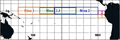
Descriptions of various ENSO indices are accompanied by an explanation of how the indices are used to detect/declare an El Niño or La Niña event.
El Niño and La Niña primarily affect the weather during the cold season. What effects does the ENSO phase have on North Texas? Click the Teleconnections link to find out!
Current Data
Various observations, including sea surface temperature animations.
Images of Current Data (from PSL)
Forecasts

Quick Links
![]() Climate Prediction Center (CPC) - El Niño/La Niña Home
Climate Prediction Center (CPC) - El Niño/La Niña Home
Weekly ENSO Update (available in pdf or ppt)
Monthly ENSO Diagnostic Discussion (available in pdf or Word)
![]() Physical Sciences Laboratory (PSL) - ENSO Information
Physical Sciences Laboratory (PSL) - ENSO Information
![]() Pacific Marine Environmental Laboratory (PMEL) - El Niño Theme Page
Pacific Marine Environmental Laboratory (PMEL) - El Niño Theme Page
![]() International Research Institute for Climate and Society (IRI) - ENSO Resources
International Research Institute for Climate and Society (IRI) - ENSO Resources