
A heat wave over the Southwest will intensify this week, peaking and expanding into the Intermountain West and northern High Plains this weekend. Critical to extremely critical fire weather conditions are forecast from the Northwest and the northern Great Basin this weekend. Particularly Dangerous Situation Red Flag Warnings have been issued. Read More >
|
The Mayfest Storm: May 5, 1995
Storms Affecting Tarrant and Dallas Counties During the late afternoon of May 5, 1995, a large cluster of severe storms approached the DFW Metroplex. These storms produced extremely large hail, damaging winds, and heavy rainfall as they passed over Tarrant County. The hail swath included the bank of the Trinity River where the outdoor festival, Mayfest, was in progress. The storms caused an estimated $2 billion in damages in Tarrant and Dallas counties. This event remains one of the costliest hail storms in history. The storms struck Mayfest at 7:10 pm, where over 10,000 people were caught in the open with little shelter. Hail up to the size of softballs fell, resulting in over 400 injuries. There were no fatalities at the festival, although 60 people suffered serious injuries requiring hospitalization. As the storms moved eastward, intense rainfall affected portions of Tarrant and Dallas counties. Rainfall rates approached 2.25 inches in 15 minutes over Dallas County and numerous reports of flash flooding were received. More than 350 cars sustained weather-related damage, including hail and water damage. Fatalities One person died in western Tarrant County when he drove into a swollen creek. Fifteen people died in Dallas County. Several of the victims drove into high water and were swept away by floodwaters. Two individuals fell into high water and drowned. Four other deaths were also reported in Dallas County, including two lightning-related fatalities and two others due to a heavy-rain induced roof collapse. Community Planning and Preparedness The Mayfest storms changed the way in which the local emergency management community and the National Weather Service communicate and collaborate to prepare for hazardous weather. As a result of these storms, the Tarrant County Radio Amateur Civil Emergency Service (R.A.C.E.S.) is now located on-site at outdoor events in and around Fort Worth to relay weather information and provide emergency support.
Springtime brings plentiful sunshine and outdoor activities ranging from festivals to sporting events and other recreational activities. However, mostly sunny skies can give way to rapidly developing thunderstorms in some situations. Thunderstorms producing tornadoes, damaging winds, and large hail can occur throughout the year, but are most common in the spring months. The National Weather Service works closely with the local media and emergency management community to plan and prepare for hazardous weather. However, you should take personal responsibility to keep your family safe. Pay close attention to weather forecasts. Be prepared to implement your safety action plan if watches or warnings are issued for your area. Flash flooding is the number one weather-related killer, followed closely by lightning. Never drive into a water covered roadway. Do not allow children to play near creeks or streams since rapidly flowing water can continue to rise for several hours after the rain has stopped. Lightning can strike many miles away from the heavy rain and hail. As a general rule, move indoors when you first hear thunder and allow 30 minutes after the last rumble of thunder before heading outside. Hailstones and gusty thunderstorm winds can also be deadly. If you are attending an outdoor festival or event, look for areas that can be accessed quickly if hazardous weather approaches. The best option is to seek shelter in a sturdy building, but vehicles can provide some safety from hail, winds, and lightning. You may also wish to look online for the event’s emergency action plan or ask event organizers.
Pictures and more information from Storm Chaser, Sam Barricklow, are available here.
NWS Storm Data – May 1995, Volume 37, Number 5 NWS Natural Disaster Survey Report: The Fort Worth-Dallas Hailstorm/Flash Flood of May 5, 1995. NWS Southern Region Headquarters. November 1995.
Special thanks to: Sam Barricklow, K5KJ Greg Patrick, NWS Southern Region Headquarters Gary Woodall, NWS Memphis
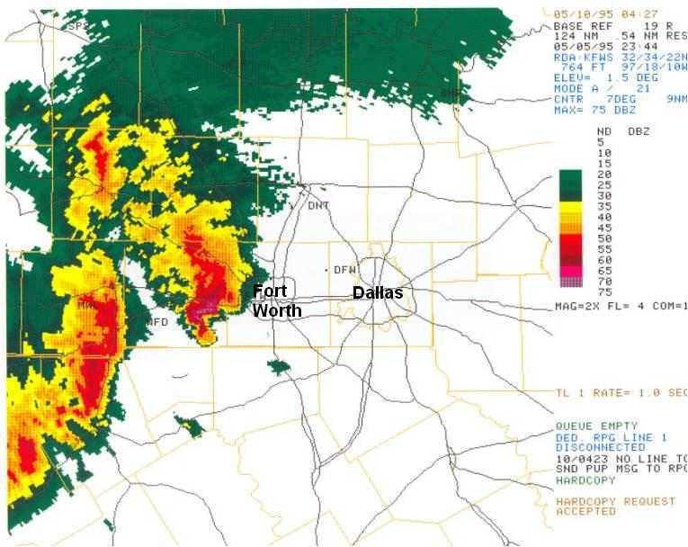
Above: Radar imagery from 6:44pm on May 5, 1995 shows the intense supercell west of Fort Worth moving east.
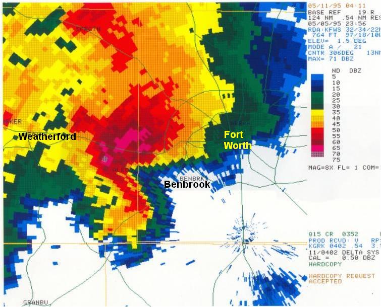
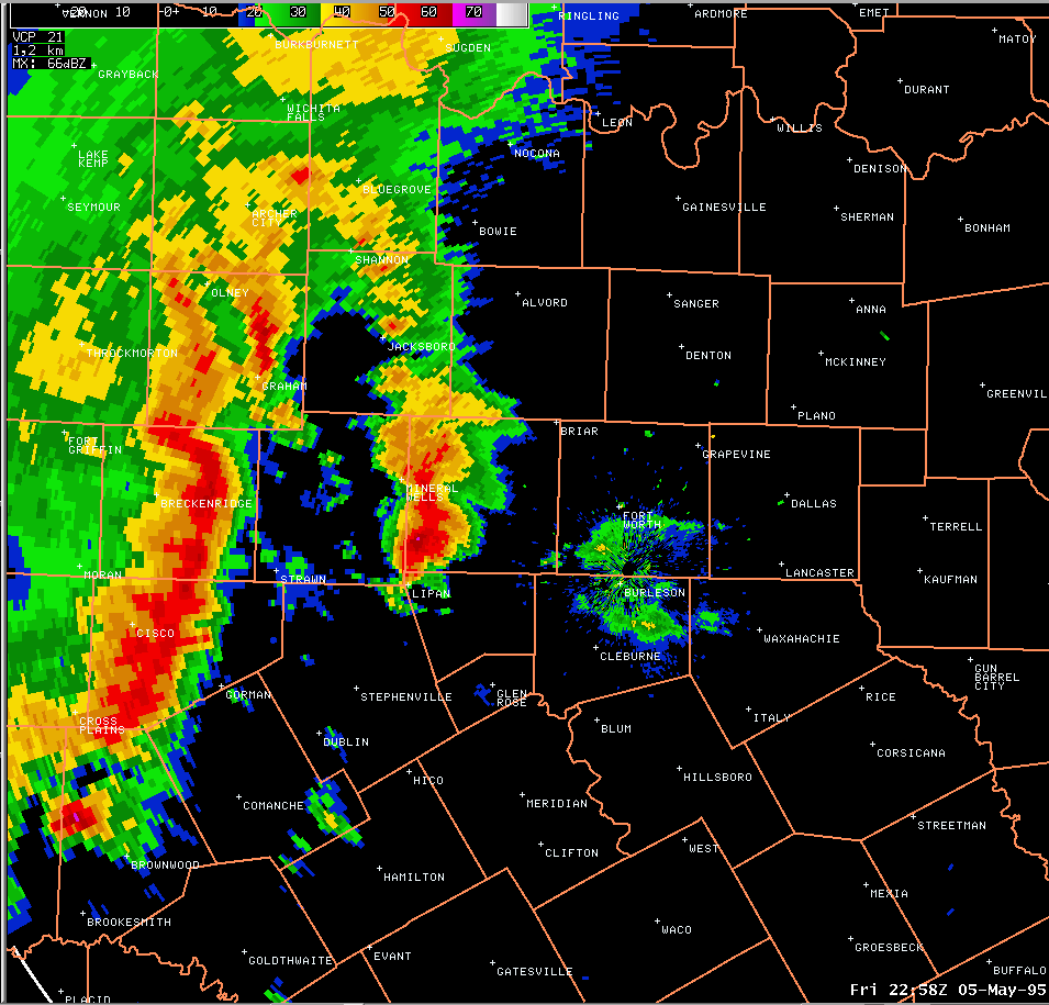
Above: Radar imagery from 6:56pm shows a close-up of the Mayfest supercell centered west of Benbrook. The pink and darkest red colors represent radar indications of large hail with this storm. The storm impacted the Mayfest festival at 7:10pm.
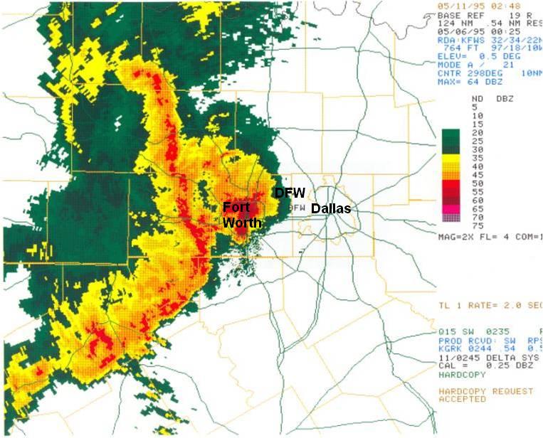
Above: At 7:25pm, the Mayfest supercell storm was affecting much of the city of Fort Worth. The squall line to the west of the supercell storm was moving rapidly east and would eventually merge with the supercell. The resulting cluster of severe storms would later move into Dallas County.
|

