
A significant heat wave is underway for the Intermountain West, Northern Plains, and Upper Great Lakes, peaking in intensity through midweek and lingering across parts of the Northern Plains and Midwest until this weekend. In southwest Texas, excessive rainfall may bring a risk for potentially life-threatening flash and arroyo flooding through Thursday. Read More >
Strong to severe thunderstorms erupted across parts of north central Kansas on Saturday afternoon, July 26, 2008. These storms formed in a very unstable airmass along a weak surface front as an upper level disturbance passed through the region. One storm in particular became quite a hail producer across Phillips County, Kansas, with reports of destructive hail up to baseball size in the community of Prairie View around 2:20 PM, breaking several windows out of homes in addition to other widespread hail damage.
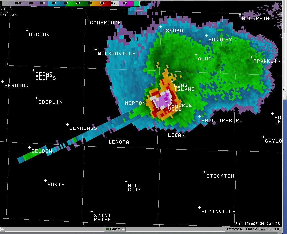
The radar reflectivity image below depicts the storm over western Phillips County at 2:09 PM. In this image we are actually looking into the storm at approximately 28,000 feet above ground level (AGL), with the radar itself located 69 miles northeast of Prairie View, near Blue Hill, Nebraska. The purple shading in the core of the storm shows very high levels of reflectivty around 70 decibels (dBZ), with values this high often a good indicator of hail within a storm.
More intriguing, however, is the long "spike" of reflectivity extending well to the southwest across parts of Norton and Sheridan counties. In fact, this "spike" is not a reflection of actual precipitation in the area, but instead is a classic example of a radar artifact known as a "Three-Body Scatter Spike", or TBSS. The presence of a TBSS almost always indicates that a storm contains large hail. In simple terms, a TBSS is caused by the radar beam hitting the hail aloft, scattering to the ground below, then scattering back upward, and finally being scattered once again by the hail aloft. The 3 scatterings illustrate the triple reflection, thus the term "three-body scatter spike".
Below the radar image is a brief list of PRELIMINARY LOCAL STORM REPORTS from various sources.
PRELIMINARY LOCAL STORM REPORT...SUMMARY
NATIONAL WEATHER SERVICE HASTINGS NE
515 PM CDT SAT JUL 26 2008
.TIME... ...EVENT... ...CITY LOCATION... ...LAT.LON
.DATE... ....MAG.... ..COUNTY LOCATION..ST.. ...SOURCE.
..REMARKS..
0223 PM HAIL PRAIRIE VIEW 39.83N 99.57W
07/26/2008 E2.75 INCH PHILLIPS KS LAW ENFORCEMENT
0228 PM HAIL 8 W PHILLIPSBURG 39.75N 99.47W
07/26/2008 E1.50 INCH PHILLIPS KS CO-OP OBSERVER
HAIL WAS REPORTED 8 MILES WEST OF PHILLIPSBURG ON HIGHWAY
36.
0238 PM HAIL 7 NW PHILLIPSBURG 39.82N 99.42W
07/26/2008 E1.75 INCH PHILLIPS KS PUBLIC
0338 PM HAIL 9 NE STOCKTON 39.53N 99.15W
07/26/2008 E1.00 INCH ROOKS KS LAW ENFORCEMENT
QUARTER SIZE HAIL
0427 PM HAIL SIMPSON 39.39N 97.93W
07/26/2008 E0.75 INCH MITCHELL KS LAW ENFORCEMENT

