
A significant heat wave is underway for the Intermountain West, Northern Plains, and Upper Great Lakes, peaking in intensity through midweek and lingering across parts of the Northern Plains and Midwest until this weekend. In southwest Texas, excessive rainfall may bring a risk for potentially life-threatening flash and arroyo flooding through Thursday. Read More >
Hastings, NE
Weather Forecast Office
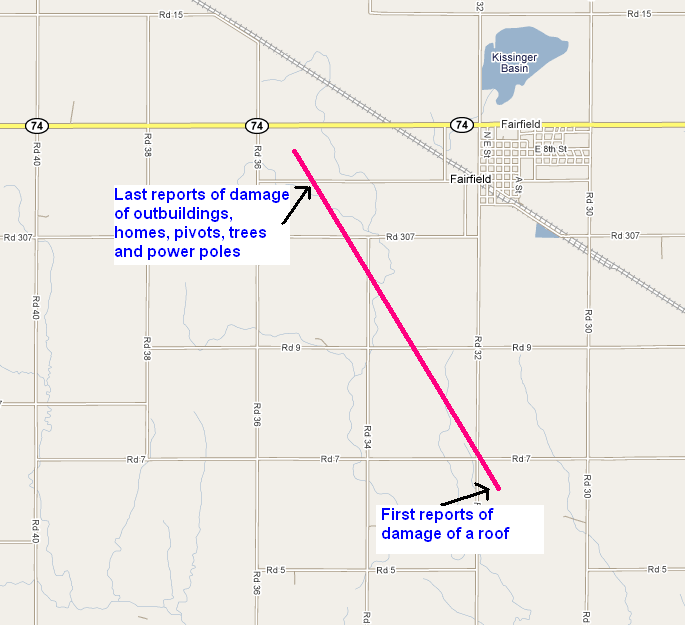
During the evening of April 4th, thunderstorms rumbled across south-central Nebraska. Most storms brought rains and some small hail. One storm did cause some damage near the community of Fairfield in Clay County. A tornado brief tornado touched down south of Fairfield and moved to the northwest. At the start, the twister took the roof off of a barn. Near the end of the tornado's path of distruction, it destroyed three outbuildings and caused damage to two homes. This tornado was rated EF0.
A little later, a second tornado touched down just east of Sutton in northeast Clay County. This tornado was also rated EF0. No damage was reported with the second tornado.
Hazardous Weather
Submit A Storm Report
Storm Prediction Center
Local Storm Reports
Experimental Graphical Hazardous Weather Outlook
Forecasts
Area Forecast Discussion
Fire Weather
Aviation Weather Center
Experimental Probabilistic Precip Amount Forecast
Winter Weather
Winter Storm Severity Index
Experimental Winter Storm Outlook
Wet Bulb Globe Temp
Activity Planner
Current Conditions
Current Area Observations
Text Products
Satellite
Rivers and Lakes
Local 24 Hour Precip Maps
Local Archived Precip Maps
NWPS Precipitation Analysis
Local Snowfall Maps
Snowfall Analysis
Snow Cover
Climate
Local Database (NOWData)
Local Climate Webpage
Hastings/G. Island Records
Local Historical Tornado Info
U.S. Drought Monitor
Grand Island - Daily
Grand Island - Monthly
Hastings - Daily
Hastings - Monthly
Kearney - Daily
Kearney - Monthly
Ord - Daily
Ord - Monthly
US Dept of Commerce
National Oceanic and Atmospheric Administration
National Weather Service
Hastings, NE
6365 North Osborne Drive West
Hastings, NE 68901-9163
402-462-4287
Comments? Questions? Please Contact Us.

