
A significant heat wave continues for the Rockies, Northern Plains, and Great Lakes into the Mid-Atlantic, peaking in intensity through midweek and lingering across parts of the Northern Plains and Midwest until this weekend. Excessive rainfall my bring life-threatening and locally catastrophic flash and urban flooding across portions of southwestern Texas through early Friday. Read More >
Hastings, NE
Weather Forecast Office
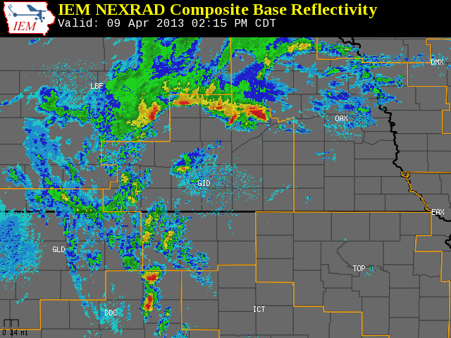
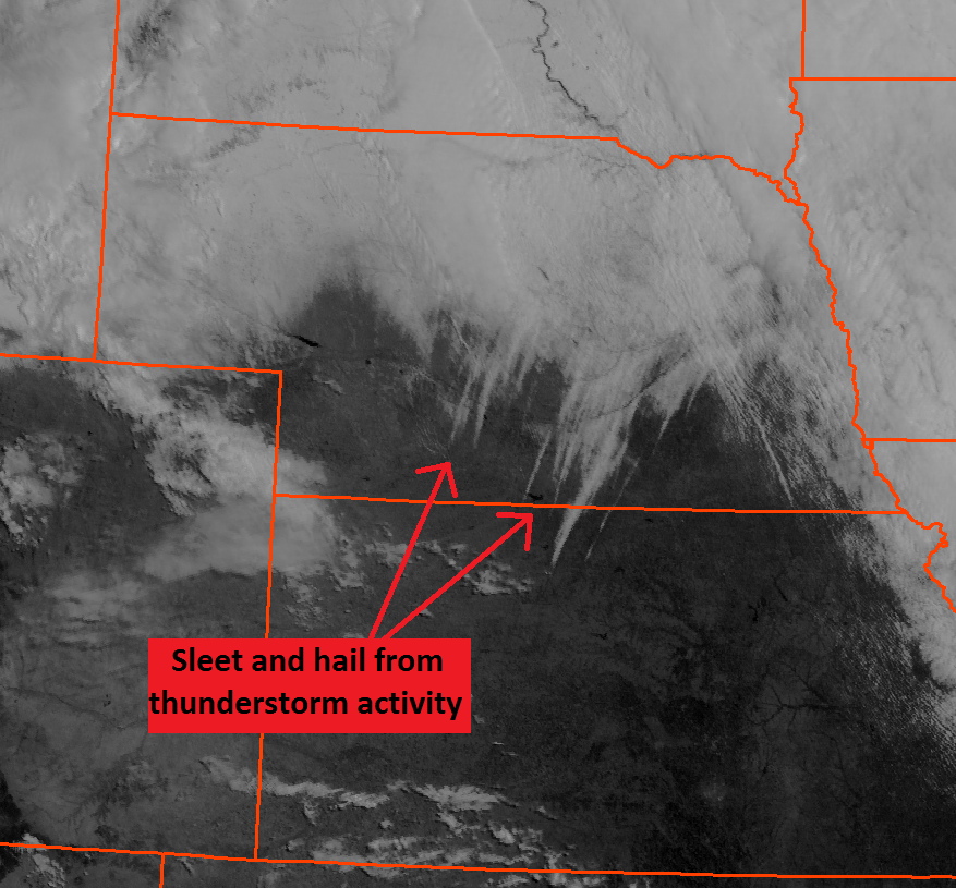
During the afternoon and evening hours of Tuesday, April 9, several thunderstorms developed and moved across portions of south central Nebraska and north central Kansas. Anybody across the area who observed these storms noticed a significant difference between these storms most other thunderstorms...instead of rainfall most locations observed an extended period sleet! Periods of hail were also observed with these thunderstorms, but sleet was the primary precipitation type with some locations reporting around a half inch of sleet accumulation. The first image below shows thunderstorm activity across the area Tuesday afternoon and evening on April 9. The second image below shows visible satellite imagery from the morning of Friday, April 12. Look closely at the satellite imagery...do you see the white streaks extending from southwest to northeast across south central Nebraska and north central Kansas? Those streaks are the sleet and hail which fell from the thunderstorm activity on Tuesday!
Hazardous Weather
Submit A Storm Report
Storm Prediction Center
Local Storm Reports
Experimental Graphical Hazardous Weather Outlook
Forecasts
Area Forecast Discussion
Fire Weather
Aviation Weather Center
Experimental Probabilistic Precip Amount Forecast
Winter Weather
Winter Storm Severity Index
Experimental Winter Storm Outlook
Wet Bulb Globe Temp
Activity Planner
Current Conditions
Current Area Observations
Text Products
Satellite
Rivers and Lakes
Local 24 Hour Precip Maps
Local Archived Precip Maps
NWPS Precipitation Analysis
Local Snowfall Maps
Snowfall Analysis
Snow Cover
Climate
Local Database (NOWData)
Local Climate Webpage
Hastings/G. Island Records
Local Historical Tornado Info
U.S. Drought Monitor
Grand Island - Daily
Grand Island - Monthly
Hastings - Daily
Hastings - Monthly
Kearney - Daily
Kearney - Monthly
Ord - Daily
Ord - Monthly
US Dept of Commerce
National Oceanic and Atmospheric Administration
National Weather Service
Hastings, NE
6365 North Osborne Drive West
Hastings, NE 68901-9163
402-462-4287
Comments? Questions? Please Contact Us.

