
Dangerous heat expands across the Desert Southwest, Plains, Mississippi Valley and Midwest. Critical fire weather for portions of the Intermountain West. Risk for severe thunderstorms and flash flooding across the Upper Midwest/Great Lakes, Ohio Valley, and portions of the mid-Atlantic. Active monsoonal moisture fuels thunderstorms over the Southwest. Hurricane Fausto in the Pacific, should weaken Read More >
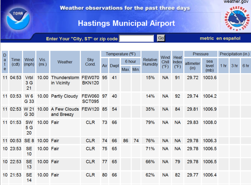
Heat bursts created rapid rises in temperature, rapid decreases in dewpoint and strong wind gusts of 50+ MPH across portions of south central Nebraska during the early morning hours of June 11th. Below are comparisons of temperature and dewpoint readings before and during the heat bursts:
| Site | Temp/Dewpoint Before Heat Burst |
Temp/Dewpoint After Heat Burst |
| Grand Island Airport ASOS | 73/67 (2:53 a.m.) | 99/41 (5:10 a.m.) |
| Hastings Airport ASOS | 73/66 (1:53 a.m.) | 97/39 (3:53 a.m.) |
| Holdrege Airport AWOS | 77/68 (12:35 a.m.) | 88/47 (2:35 a.m.) |
| Kearney Airport AWOS | 75/66 (12:55 a.m.) | 97/43 (3:15 a.m.) |
| Lexington Airport AWOS | 79/68 (11:55 p.m.) | 87/48 (2:15 a.m.) |
| Aurora Airport AWOS | 73/63 (5:37 a.m.) | 91/46 (6:38 a.m.) |
What is a heat burst?
A heat burst is caused when a shower or thunderstorm weakens over a layer of dry air. As the last of the precipitation from the weakening shower or thunderstorm falls through the layer of dry air, the precipitation begins evaporating thus causing the air to cool. As this air cools it will become more dense, eventually more dense when compared to the surrounding warmer air and as a result, begins descending to the surface at a high rate of speed. Eventually, all of the precipitation within the descending air evaporates. At this point the air is completely dry and because no more evaporation can occur, the air can no longer cool. The air however continues to descend toward the surface due to the momentum it has already acquired. As dry air descends through the atmosphere, compression due to increasing atmospheric pressure causes the the air to warm. It is important to note that the density of this air is now going to begin decreasing because of the increasing temperature. However, because the descending air already has a great deal of momentum carrying it to the surface, the increase in temperature and resultant decrease in density does little to slow the descending air. So, the dry air continues to descend, all the while warming more and more due to the aforementioned compressional heating. Eventually, this descending air reaches the surface and the momentum, which was moving downward towards the surface, is now moving horizontally along the surface in all different directions, thus resulting in a strong wind! In addition, the intrusion of the very warm and very dry airmass from aloft, will cause the temperature at the surface to increase very quickly, and the dewpoint at the surface to decrease very quickly. Acquiring all the needed ingredients for a heat burst can be difficult, thus making the development and observance of a heat burst rare.
 |
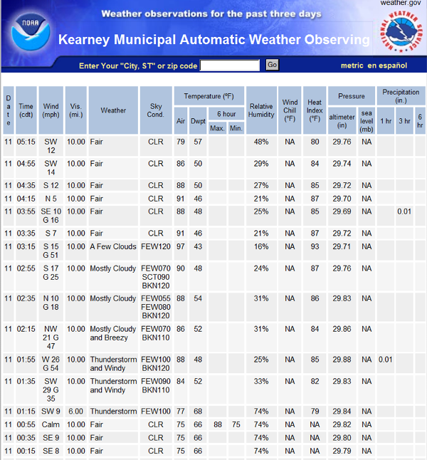 |
| Observations from the Hastings Airport ASOS. | Observations from the Kearney Airport AWOS. |

