|
Event Summary:
An upper level disturbance gradually making its way through the Rocky Mountains brought increased lift to the region during the evening and overnight hours of Saturday, December 7th and into the morning hours of Sunday, December 8th, resulting in accumulating snowfall. For a large chunk of the NWS Hastings coverage area, this was the first 1-2+ inch snowfall of the 2013-2014 winter season. This snow fell into a very cold airmass, making the snow unusually dry and fluffy, and with an overall lack of wind, the snow accumulated efficiently and evenly. The NWS Hastings coverage area ended up with a wide range of snowfall totals, with little if any accumulation noted in far western and northern counties such as Dawson and Valley, compared to a solid coverage of 4-7" across several counties mainly south of Interstate 80 in Nebraska and north of Highway 24 in North Central Kansas. In between these extremes, locations such as Grand Island, Kearney and Hastings reported official totals ranging from 2.1" to 4.4", with an unofficial total of 5.9" measured a few miles southeast of Hastings.
Below is a list of "official" storm total snowfall mainly from NWS Cooperative Observers, along with a few totals from the NeRAIN network Please note: although some unofficial estimated higher totals (not depicted here) were reported during the event, this story only focuses on official measured data. Because most NWS observers report snowfall in 24-hour periods ending around 8am, there are three columns presented to distinguish snowfall that fell over the first 24-hour period and the second 24-hour period, and finally the storm total. Please note that any sites with an asterisk next to their name may not necessarily be a "storm total" amount due to missing data.
| Location |
Snowfall as of approx.
8am on Dec 8th |
24-hour Snow as of
8am on Dec 9th |
Storm Total Accumulation |
| 3N York |
6.0" |
1.5" |
7.5" |
| 6 ESE Clay Center |
4.0" |
3.0" |
7.0" |
| Clay Center |
6.0" |
1.0" |
7.0" |
| Naponee |
6.0" |
1.0" |
7.0" |
| Burr Oak KS |
5.8" |
1.0" |
6.8" |
| Minden |
6.0" |
0.5" |
6.5" |
| Red Cloud * |
6.5" |
Missing |
6.5" * |
| Lebanon |
5.5" |
1.0" |
6.5" |
| Hebron |
4.2" |
2.3" |
6.5" |
| Mankato KS |
6.0" |
Trace |
6.0" |
| Bruning |
5.0" |
1.0" |
6.0" |
| Bradshaw |
5.0" |
1.0" |
6.0" |
| Wilsonville |
4.0" |
2.0" |
6.0" |
| Phillipsburg KS |
5.0" |
1.0" |
6.0" |
3 SE Hastings
(unoffical NeRAIN) |
5.5" |
0.4" |
5.9" |
| Franklin |
4.2" |
1.5" |
5.7" |
| 4E Superior |
4.0" |
1.2" |
5.2" |
| Ionia KS |
4.7" |
0.4" |
5.1" |
Alma
(unoffical NeRAIN) |
5.0" |
0.0" |
5.0" |
| Holdrege |
4.0" |
1.0" |
5.0" |
| Geneva |
5.0" (through 5 pm) |
0.0" |
5.0" |
| Blue Hill 4SW |
3.0" |
1.5" |
4.5" |
Hastings NWS
(official Hastings snow) |
2.5" (through midnight) |
1.9" |
4.4" |
| Edison |
4.0" |
0.3" |
4.3" |
| Smith Center KS |
4.0" |
0.2" |
4.2" |
| 4N Aurora |
2.5" |
1.5" |
4.0" |
| 2SW Alton KS |
2.0" |
2.0" |
4.0" |
| Natoma KS |
2.2" |
1.0" |
3.2" |
| Cambridge |
2.0" |
1.0" |
3.0" |
| 8 S Elwood |
1.5" |
1.5" |
3.0" |
| 4WNW Plainville KS |
1.5" |
1.5" |
3.0" |
| Kearney airport |
2.0" |
0.4" |
2.4" |
| Osceola |
1.7" |
0.5" |
2.2" |
Grand Island airport
(official G.I. snow) |
1.0" |
1.1" |
2.1" |
| Hunter KS |
1.0" |
1.0" |
2.0" |
| 3 NE Shelby |
1.4" |
0.6" |
2.0" |
| Miller |
1.0" |
0.5" |
1.5" |
| St. Paul |
1.0" |
0.2" |
1.2" |
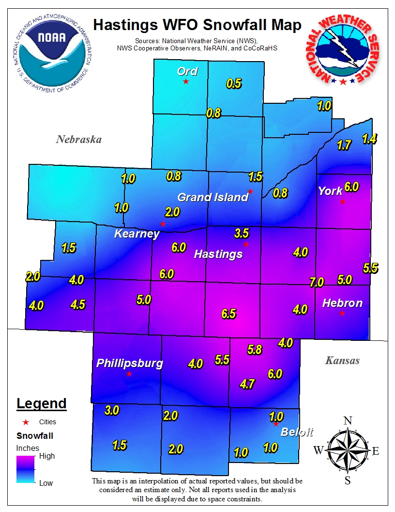
Here is a map showing snowfall totals ending at 8 a.m. Sunday, Dec 8th.
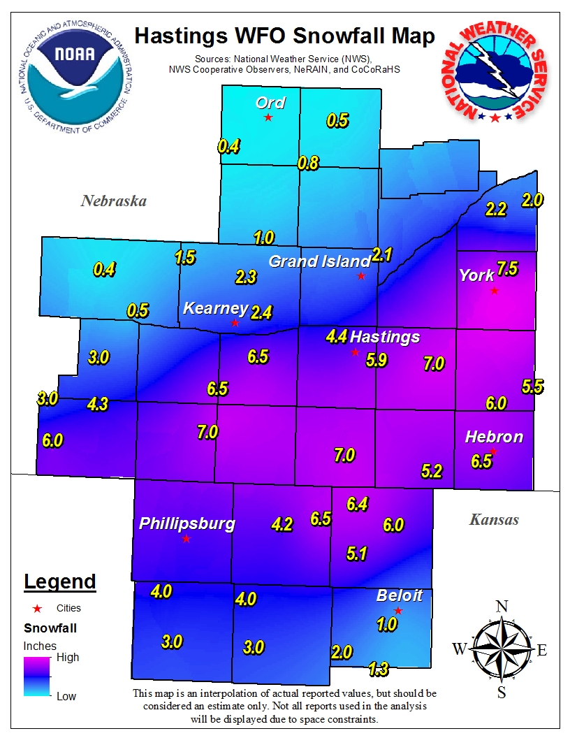
Here is a map showing storm total snowfall amounts across the Hastings forecast area.
Note: this map will only show those sites that reported on both days of this event.
|