April 16-18, 2016: Widespread, Much Needed Rainfall Across Most Of The Area
Event Summary
During the first half of April 2016, the NWS Hastings coverage area of South Central Nebraska/North Central Kansas (Click HERE for a map) fell deeper into a prolonged dry spell that had persisted for over 2 months since a significant early February winter storm/blizzard. In general, most of the area received no more than 10-30% of normal precipitation during the stretch from February 3 - April 15, promoting a favorable environment for early spring grass fires.
However, this all changed in a BIG way during a much needed stretch of wet, rainy weather centered from Saturday, April 16 through Monday the 18th. During this 3 day period, nearly all local counties along/west of Highway 281 corridor received widespread rainfall of 3-6" (and locally higher) as an expansive, slow-moving upper level low pressure system remained anchored over the Central Rockies. In fact, for many official weather stations this marked one of the biggest multi-day rain events on record for the month of April! During this same time, counties east of Highway 281 saw lesser rain totals of generally 1-2", but many of these places ended up receiving at least 0.50-1.00" a few days later between April 19-20 (please note: this story and associated images only focus on rainfall between the 16-18th).
Not only was this an extremely beneficial heavy rain event for replenishing soil moisture at the start of the growing season, but it also was somewhat unusual in that it featured little, if any, flooding. This was due to 2 primary factors:
- The soil profile was quite dry heading into the event and thus was primed to accept plenty of rain without excessive runoff.
- Unlike most heavy rain events where several inches fall in a 6-12 hour period, this rainfall was pretty evenly spaced out, gradually adding up over the course of 2-3 days.
As for specific rain totals, please refer to the table below for data from dozens of local NWS cooperative observers and CoCoRaHS observers. However, a few of the highest 3-day measurements included 5.86" near Sumner in Dawson County and 5.48" near Plainville, KS in Rooks County. Radar derived estimates suggest that a few places likely received at least 6-7" (especially in Rooks, Phillps and Howard Counties).
Focusing closer on timing, this multi-day event first got underway in far western portions of the local area (mainly west of the Highway 183 corridor) during the early morning hours of the 16th. Then, the daytime of the 16th into the morning of the 17th featured the overall heaviest rain of the event, as most counties along and west of Highway 281 tallied 2-4". Off-and-on rain then persisted through the 17th and into the morning of the 18th, while gradually shifting its focus farther east. Other than some lingering light drizzle, a brief stretch of dry weather finally returned on the afternoon and night of the 18th into the 19th, thus ending the "main event" outlined in this story.
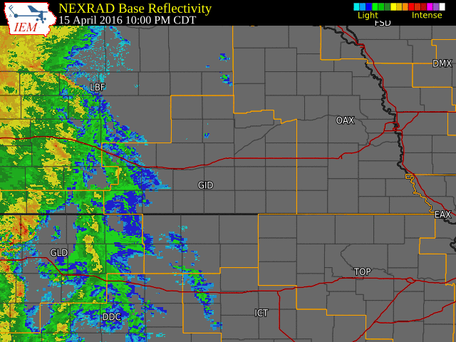
Radar Overview
The NWS radar loop below runs from 10:00 p.m. April 15th to 12:00 p.m. CDT April 18th.
The NWS Hastings coverage area is located within the orange outlined area labeled "GID".
Click on image larger version
Below is a table of storm total precipitation amounts from around the area. These reports come from NWS Cooperative Observers, NeRAIN/CoCoRaHS Obsevers and automated stations.
| Location |
April 16-18 Rainfall |
| 4 ESE Sumner |
5.86 |
| Cairo |
5.50 |
| 4 WNW Plainville, KS |
5.48 |
| Riverdale |
5.47 |
| Kearney Airport |
5.45 |
| 2 NW Rockville |
5.45 |
| 3 NE Boelus |
5.41 |
| Loomis |
5.31 |
| 4 S Cozad |
5.22 |
| Wood River |
5.21 |
| Ravenna |
5.13 |
| Dannebrog |
5.11 |
| 3 SSE Scotia |
5.10 |
| Hildreth |
5.09 |
| 6 SW Lexington |
5.07 |
| Orleans |
5.03 |
| 10 WNW Stockton, KS |
4.95 |
| Miller |
4.95 |
| Cambridge |
4.93 |
| Minden |
4.89 |
| Wilcox |
4.87 |
| Holdrege |
4.84 |
| 1 SE Kenesaw |
4.73 |
| Campbell |
4.70 |
| 2 SW Alton, KS |
4.70 |
| Logan, KS |
4.60 |
| Loup City |
4.48 |
| Phillipsburg, KS |
4.47 |
| Franklin |
4.38 |
| Ord |
4.35 |
| 6 NNW Oxford |
4.25 |
| Wilsonville |
4.25 |
| 6 ESE Lexington |
4.25 |
| Smith Center, KS |
4.25 |
| Natoma, KS |
4.25 |
| 4 SW Blue Hill |
3.98 |
| NWS Office (4 N Hastings) |
3.79 |
| Lawrence |
3.78 |
| 4 E Red Cloud |
3.73 |
| Arcadia |
3.69 |
| Lebanon, KS |
3.62 |
| Greeley |
3.58 |
| 8 S Elwood |
3.48 |
| Beaver City |
3.43 |
| Hastings Airport ASOS |
3.43 |
| Mankato, KS |
3.15 |
| Ionia, KS |
3.03 |
| Covert, KS |
3.03 |
| Grand Island Airport ASOS |
2.98 |
| Osborne, KS |
2.98 |
| Burr Oak, KS |
2.89 |
| Beloit, KS |
2.20 |
| Superior |
1.99 |
| Belgrade |
1.68 |
| Osceola |
1.41 |
| 3 N York |
1.23 |
| 4 N Aurora |
1.21 |
| Clay Center |
1.00 |
| Geneva |
0.93 |
| Hebron |
0.87 |
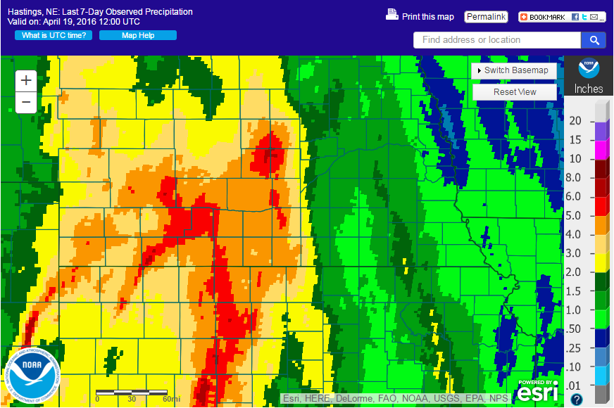 |
| April 16-18 Rainfall. Click for larger image. |
 |
This page was composed by the staff at the National Weather Service in Hastings, Nebraska. |
 |